Our entire family got the evil COVID as a Christmas present this year. We had to delay our trip to Canada because of it. I wasn’t happy especially because I think it could have been avoided if a certain unnamed person (not me) hadn’t gone out to see my wife when he was sick, although we probably would have gotten it somewhere else since it seems to be going rampant again.
Needless to say I was quite sick last weekend and did not hike. This weekend, however, I felt much better. I was definitely going hiking. The last hike of 2023. The last waterfall of 2023.
I tried this one a few years ago by going straight up the creek from the road. That did not work. I came fairly close and got a glimpse of the waterfall but there was no way to get up to it. My next try would be to attempt it from above, but in the meantime the Dixie Fire of 2021 raged through the area, destroying everything in its path, and in 2022 the entire canyon (along with nearby Murphy Creek) was washed out in a flood.
Now it is the end of 2023 and time to try again. On Google Earth everything looked burned out and desolate but I did not see that on my hike. In fact it didn’t really look like anything had burned. It has all grown back now, and that includes the poison oak. There was a lot of that.
I got to the creek and parked, got all my gear out, locked the car, and started my hike. Something was wrong. I could feel it. In my bones. What is wrong? I knew I forgot something. I had my water. I had my backpack. I had my hiking pole. I had my camera. Doh! I did not have my tripod! I forgot the darn tripod back at the house. Argh! The reason is because I took my wife’s car this time and did not transfer it. Normally I just leave the tripod in my car. I transferred my hiking pole but not the tripod. Darn it. What am I going to do now? Well I would figure it out once I got up to the waterfall. I probably wouldn’t make it anyway.
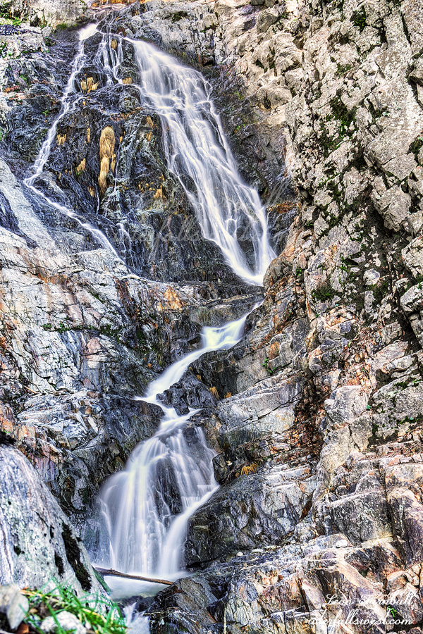
It was not too difficult climbing up the mountain or too brushy. The biggest problem was the poison oak. It was steep and there were a lot of loose rocks. I had to be very careful but as I approached the waterfall from near the top I could see a way down to it. It was not cliffy as I feared. I was not able to get all the way down to the creek but I made it to a fantastic viewpoint of the waterfall. Opapee Creek Falls is 103 ft. high and it is very lovely indeed. At high flows it will be spectacular. I am sure I will be back here some day. With a tripod. Thankfully there was a nice spot where I could put my backpack down and set my camera stably on it and this allowed me to take good photos of the waterfall with no tripod. Sweet.
Initially I had planned a second hike in the afternoon but decided to skip it for four reasons: (1) my trek to Opapee was so successful and also harder than I thought it would be. (2) no tripod. This was the biggest reason. I was lucky for a spot to set up the camera on my backpack but probably would not have such luck at additional spots. (3) poison oak. I needed to get home and wash up before it was too late. (4) still recovering from COVID. not really a big problem as I felt pretty good but still it was probably smart not to push it too much.
It was a great morning in Plumas National Forest with yet another new waterfall discovery.
As of Dec 1 the snow pack in California is about 26% of normal overall. It is a disappointing and pathetic start to the new season. All the rain is going into the Pacific Northwest thus far. This is not supposed to happen in an El Nino year, especially for a strong El Nino. But … obviously it is still early. Winter doesn’t really even begin until December so hopefully it will turn around soon. I would like to see us at least get an average winter. That is not too much to ask, right?
Anyway, I did not feel like doing much this past weekend but I wanted to at least go out with Journey somewhere. Our church service was not until the afternoon on Sunday so we got up early in the morning to go to Auburn. It has been 16 years since I have been to Lake Clementine Falls. It would be nice to go back there with Journey. However, I forgot it was the day of the marathon. The road to Auburn was closed. Ugh. Now what? Journey will be mad at me if I just go back home now (after waking her up so early!). I decided to go the long way around to Auburn. We had lots of time.
I parked at the Foresthill Bridge. The parking is free. If I park at the Confluence it is not free. I know I could get a free pass at the library but it is inconvenient. On the downside, there is a 700 ft. descent from the bridge down to the river, but this would be a good hike for the two of us and not too difficult.
I have not ever walked across the Foresthill Bridge before but I was really pleased I did so and not because of the views (though they are good). It is the highest bridge in California and I guess people have committed suicide jumping off it, though I do not think I have heard of anyone doing so on this bridge. I was stricken, however, as I read all the notes that someone left on the bridge every ten feet all the way across. Positive notes for people who might be thinking of jumping: bible verses, and other notes saying God loves you, don’t give up, etc. I just thought that whoever did this is a very awesome person. It made my day.
When I arrived there was a lot of fog in the valley and the bridge was enveloped in it. I came to a spot that would make a great photo so I stopped but by the time I got the camera out the fog was mostly all gone. Ugh. Maybe the waterfall would have fog? Likely story. By the time I made it all the way up there it had long since dissipated. Oh well.
It was a lovely hike along the river. Except for all the garbage. Why are people such a-holes? I picked up more than my fair share including some yucky stuff but there was plenty more to be seen. We arrived at the waterfall. It is a little bit steep on slick rock getting down to this viewpoint but Journey did great and made it down. I took some photos and we hiked back along the river and then up the steep hill back to the bridge and car. She was quite tired after that big 700 ft. climb. It was a lovely morning in Auburn State Recreation Area.
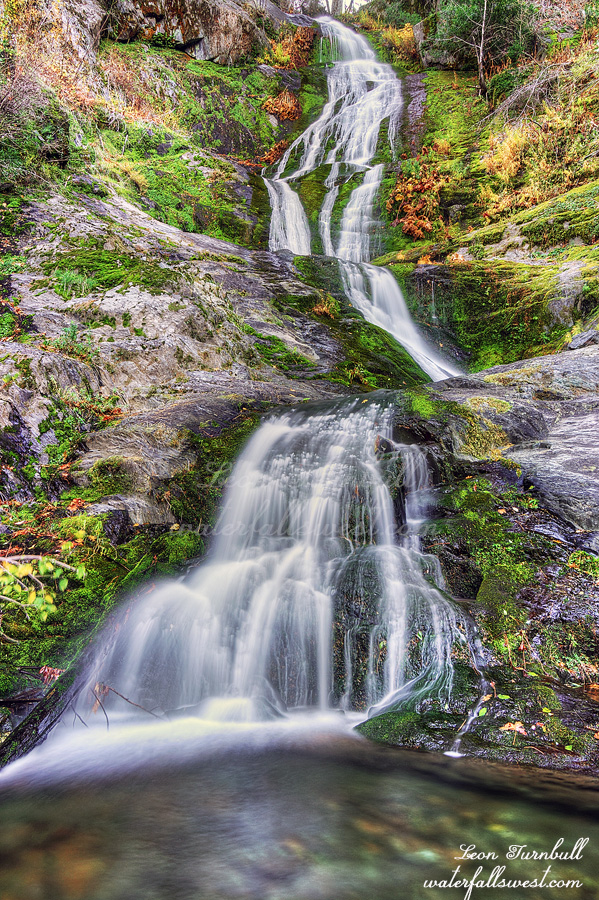
Meet Upper Bear Ranch Creek Falls, 112 ft. high. It took me four tries to get here and I was absolutely ecstatic that I finally made it.
I was in the area the prior week trying to get to this waterfall but it was an epic fail. After the Bear Fire in 2020 the brush has grown up tremendously. This route was now impassable. Before the fire I think this might have been a good route. Now, not a chance. Somehow while whacking through all the bushes I lost my Garmin Inreach. I was so mad at myself. I did not have it securely attached to my person and it fell off into the brush. I retraced my steps exactly but did not find it. Back at the top of the mountain, I had cell service so I called my wife and asked her to ping the device, which she did but there was no response. I figured it must be under some trees or logs and now is lost forever. Once I got back home I tried pinging it again. It was the same thing my wife did but this time I got a response! Now I had a location where it was and I could go back sometime and get it. But time was running out. Once it snowed I would not be able to go back until spring and snow was in the forecast for the next week. I literally had just one day to go back there, Sunday on my way home from visiting family up north for Thanksgiving weekend.
It would not be a difficult hike to go back. I figured just 6 miles round trip and 300 ft. of elevation gain. Thankfully it was not at the bottom of the canyon. I did not want to just go back to do this one hike, however. I decided to do a second hike first to another waterfall. I was not planning on Upper Bear Ranch Creek again, I was planning a different (easier) hike, but that also turned out to be far too brushy and impassable. Well …. what to do now?
I thought about taking a different route to Upper Bear Ranch Creek Falls. Perhaps it would not be as brushy. Heck, why not? I had all day. The new route was not so brushy, however, it was very steep and very cliffy. I had to be very careful in some spots. I got most of the way down the canyon and came to the top of a cliff. I thought I was done. I decided to just check out one more spot to see if it was passable and lo and behold, I was able to continue! Past the final cliff, I could forge on all the way down to the creek and to the waterfall. I was in shock that I actually made it down all the cliffs. I was in awe at the beauty of this majestic waterfall. I was so happy you have no idea. This one has been a long time in the making. I do not know of anyone else that has been here before.
I climbed back up the mountain 1700 ft. in elevation and back to my car. I was very tired but I still had a second hike to go retrieve my Garmin. Thankfully someone had cleared the fallen logs across the road and now I could drive much of it. Instead of a 6 mile hike it was more like 3 miles. I easily made it down to the area where the device was pinged. I could not see it. It was not in the exact location where it was supposed to be. I searched the area for about 20 minutes. I could not see it. Multiple passes. Praying fervently. I decided to make one last pass and then I saw it! I must have walked by it at least once without seeing the thing. I was so happy! Woo hoo! Thank you, Lord!
It was a fantastic day to see this amazing waterfall in Plumas National Forest.
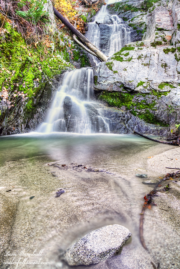
Black Friday. Best day of the year to go shopping. Not! Best day of the year to go hiking. Absolutely! Journey and I were up again very early. This time: Whiskeytown Lake. It has been a long time since I’ve been to Boulder Creek Falls (15 years). It was closed after the Carr Fire of 2018 but is open now finally. I thought a return trip with Journey would be perfect. I could not get to the traditional trailhead. According to the park website, South Shore Dr. is now open. It was not open. How was I supposed to get to Boulder Creek Falls now? I knew the trail was open. Did I have to go on S. Shore Dr. from the other side? Honestly, I am not sure. However, I saw a sign for Boulder Creek Falls trailhead on this side of the lake. Weird. This was not the traditional route. I looked at my map and it seemed like it was possible to get to the waterfall from this side, and it looked to be about the same amount of mileage and elevation gain. OK then. Let’s hike!
It was a relatively easy, straightforward hike. Perhaps not as nice because a lot of it was on a road. At the end, there was one big boulder that Journey could not jump up so I had to lift her. And then there was a very narrow, rocky section along the creek. She did great. We arrived at the falls. It was flowing fairly nice, just about what I expected. I took some photos. Journey again waited patiently. The path to the upper waterfalls looked to be very overgrown and steep, and I did not really feel like going up there. Neither did Journey. We skipped it and hiked back.
Boulder Creek Falls is somewhat interesting now. First, it is a lot more photogenic than it used to be. A lot of the branches and logs in the waterfall are gone. Two, there used to be a bench to sit on but it’s long gone (a Carr Fire tragedy?). Three, the trail to the upper Falls used to be very nice but now it is overgrown and difficult to even see. Four, the trail I went on is a new trail. It is much shorter and easier than the traditional route. That is, if the road is open (which it wasn’t for me although I think it is open in the summer).
As soon as I got Journey back in the car, she immediately laid down and closed her eyes. She was completely pooped out from the hike. I was surprised. It was about the same distance hike as the previous day with just a little more elevation gain. I got her a hamburger. She perked up a bit for that but then slept when we got back to the house. She had an awesome but very tiring day at Whiskeytown Lake.
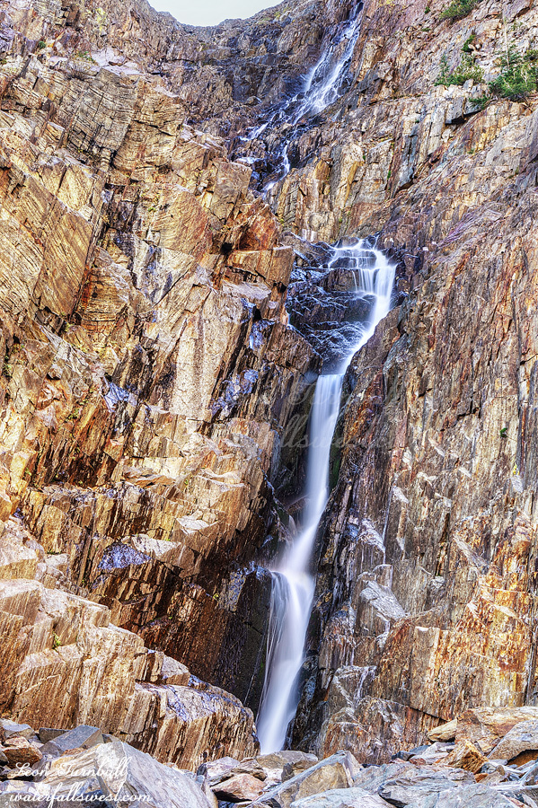
After photographing the lower Falls, I continued up the trail. I had only wanted to photograph waterfalls that had fall color, but I ended up photographing all of them anyway. Of course I knew the big waterfall would not have any fall color. The last section up to the big waterfall is very rocky, so I had to be extra careful because of my broken pinky toe. I made it up to the bottom of the falls and took photos. I did not go up on the steep and dangerous part to get a closer view of the waterfall. That probably would not have been a good idea. After photographing, I relaxed, had a snack, and then slowly walked back down the trail to the car. Taking my time, and enjoying the views. There were many people, as I mentioned earlier.
All in all, my toe was very good on the hike. It was a little bit achy, but there was no pain. I initially had thought about doing a second hike in the afternoon, but decided against it. I am sure I could’ve done it, but I thought I would just go home and relax for the rest of the weekend instead. After getting totally ripped off buying gas in Bridgeport, I arrived home in the afternoon, just in time to watch the hockey game. It was a glorious day in Lundy Canyon.