This is my recent 2 day solo backpacking trip to Lake Lois, Desolation Wilderness, Eldorado National Forest, California, near Wrights Lake / Lake Tahoe. It was Memorial Day weekend. There was still 5 feet of snow at Lake Lois, it was fantastic, and I found a couple beautiful waterfalls as well. Desolation Wilderness is one of my favorite areas to hike and backpack.
Grab some popcorn and watch my newest waterfall madman release. Please share and subscribe!
For my Black Friday, as I always do every year, long before REI ever came up with the idea, I go out hiking. My hike this year was going to be an epic one, but unfortunately did not quite turn out that way. It was a long one, however. I hiked 17 miles; I started my hike before sunrise, and it ended after sunset. Wow!
I started at the Salt Springs Reservoir hiking into the Mokelumne Wilderness. All access roads to the reservoir have been closed due to storm damage from last year. Two of the roads are still closed. I noticed on the Eldorado NF website, however, that Ellis Road is now open. It seemed like the perfect time to get back here. This road will be closed soon for winter, but it is not closed yet, and the river would be flowing strong as well. It was going to be awesome.
Surprisingly, I was not the only one out so early at Salt Springs Reservoir. There was a car parked at the trailhead where a fisherman was sleeping in his vehicle. I think I woke him up, but he did not seem to be upset about it, and we chatted briefly before I started my hike. Even though I started early, the hike to the end of the reservoir took longer than I thought it should. I do not really understand why. I also found a multitude of ticks. The first ticks I have seen this season, and there were a heckuva lot of them. It is only November, far too early for ticks. I was constantly swatting them off the brushes with my hiking pole as I hiked along the trail. By the end of it, the ticks had worn me out. Literally. And I think it cost me a bite. When you get to the end of the reservoir, there is something else to worry about too: poison oak. Somehow, I managed to get in the wrong place, right in the middle of the stuff. Fortunately, I somehow managed to avoid getting the big itch, which is a miracle, considering how late it was before I could get home and wash myself down.
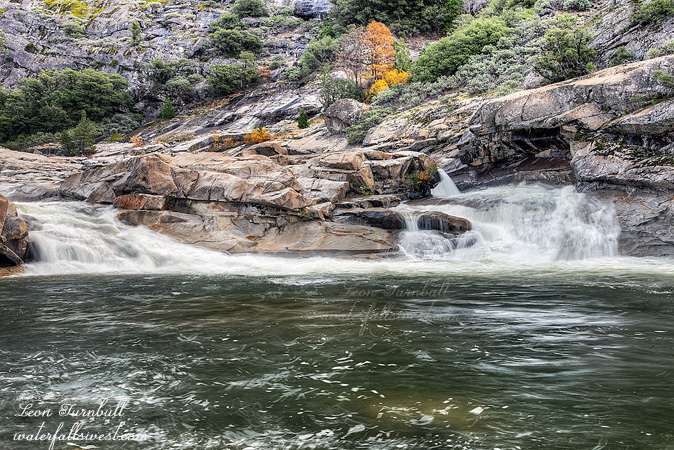
So I was already running late, tired from swatting ticks, and already in the poison oak. I took a long distance photo of the Blue Hole Falls which I have been to previously, then continued hiking up the river. There is no more trail, or not much of one anyway, but it is fairly easy going. I did not see any ticks in this area, thankfully.
I came to this 20 ft. high waterfall, which is called Island Slide Falls by the kayaking community. It is easy to see why it is called this, as the river splits around rocks at the top of the falls. It is a gorgeous slide. I debated about even going to this waterfall because it is out of the way, and delayed me even more. As it turned out, I am glad I did go here.
From here I retreated in order to climb up the mountain. I went the wrong way up and it took much longer than anticipated. More delays. Frankly, I thought I was going to get cliffed out and not be able to get all the way up, but I made it up successfully. I then started going down the other side. Now I did get cliffed out. There was a tremendous amount of brush, and major cliffs. I could not get back down to the river. I retreated back up the mountain, and ate my lunch at the top. The views of the Mokelumne Wilderness are stunning from here. However once again, I could not get to Fantasy Falls as I had hoped to do. Will I ever try it again? Yes, for sure I will. After I ate my lunch, I did find a possible route down. I don’t know if it will work or not, but I marked it with my GPS. I think next time, however, I will backpack in here. That will give me more time.
I went back down the mountain (the proper way). It was late, I was tired, I was out of water, and I still had 7 miles to hike back to the car. I filled my water reservoir in the river, then made the long hike back. I tried to hike at a fast pace on the downhill parts. I did not want to be hiking back in the dark. You cannot see ticks in the dark. I arrived back at the car just after it started getting dark. It was not until I got back home that I noticed I had a tick embedded in my backside. I had to get my daughter to get it out for me. It is odd that I did not notice it biting me beforehand. How long had it been embedded? Thankfully, it was not a bad bite. It was a long but beautiful day in the Mokelumne Wilderness.
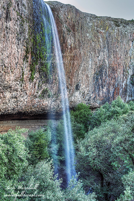
So here is photo proof that I went to the base of Phantom Falls. I do not really like the photo too much, but here it is anyway. Hopefully, I will get out and get a new waterfall this weekend.
And if you missed the video be sure to watch it (in HD). It is hilarious.
This is Hidden Falls, on North Table Mountain, Oroville. It is definitely quite hidden. It is also definitely quite a difficult waterfall to photograph, there are not many angles to photograph and no foreground to use. Only the bottom tier of the falls can even be seen. The top tier is “hidden” out of sight behind the rock.
The FINAL snow pack data is finally in (actually, I meant to write this on my last post). The results, as expected, are very piddly. Northern Sierra Nevada: 24 percent of average snowpack (last year 46%). Central Sierra Nevada: 40 percent (last year 55%). Southern Sierra Nevada: 31 percent (last year 38%). The reservoirs current levels: Folsom: 50 percent (last year at this time: 65%), Oroville: 51 percent (last year 86%), Shasta: 51 percent (last year 85%). As you can see, this latest storm did increase the snow pack a bit (from about 15 percent to 30 or 40 percent). However, that is still way below average, and the reservoirs are only at 50 percent, there is not enough snow in the mountains to fill them or supply our needs in the summer. I am still hoping and praying we get one more big storm this year. There is still plenty of time for that.
The snow has already started melting in the mountains as of this week. It has been very warm out this week. In fact, the river levels are pretty high this week, and the waterfalls, if you can get to them, will be flowing now in the mountains. I do not expect this to last more than 2 or 3 weeks this year. Now is the time to go see the waterfalls in the mountain, people. Do not wait long. There is not very much snow to melt this year. Peak snow melt is right now. Get out there!
Here is the video of our trek to the base of Phantom Falls that I made with my friend Mountain Goat Rob. It is hilarious, thanks to him, so you gotta check it out. Please watch in HD:
I was not intending to come to this particular waterfall, but sometimes that is just how things roll with me. I was hoping to drive up on Foresthill Rd and at least hoping to get to Beacroft if not further. As I drove through Foresthill, I found that it had snowed the previous night as far down as the town. That is about 3500 ft. elevation! I was pretty surprised about this. If there was snow this far down, then getting to Beacroft would certainly be impossible. I did not even try. I turned around and started thinking about Plan B. I seem to be going to Plan B a lot lately.
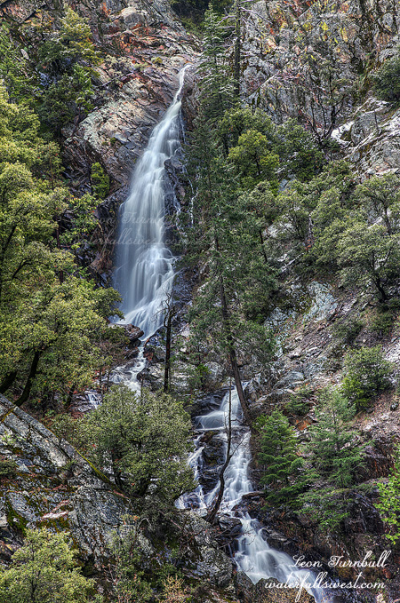
Plan B would be to go back to Big Mosquito Falls. I have been wanting to get back to this waterfall when it has good strong flow and try to get down to the bottom of it. It has been awhile since I was here last, but I wondered if I could even get to this waterfall. As I drove up Mosquito Ridge Rd I came once more into the snow. The turnoff is at about 4500 ft. elevation, and there was quite a bit of snow. The road goes downhill from there, but it is a steep downhill, and I was worried about getting into a jam way out here in the middle of nowhere. I am sure I could have done it, but I decided to walk. It was less than 2 miles, so it was not a problem to walk it. Besides, I needed the exercise anyway. That is what I told myself anyway.
Getting down to the bottom of the falls was an issue. It is steep enough anyway, but with the wet snow, the path was very slick, and a tad dangerous. I took it very slowly and very carefully, and I made it down to a great viewpoint of the waterfall. From the top of the ridge, there is no good view of this waterfall. But down at the bottom, the view is spectacular. I did not go all the way down to the bottom of the falls, as I was sure I would not get any better view.
I had wanted to go further downstream, but I decided against that as well. The sun was out, and the hike so far was longer and more difficult than initially anticipated, and there was a lot of poison oak, so I decided to leave that adventure for another day.
Nonetheless, on the drive back home, I did find one new waterfall for sure, perhaps even two. However, I could not get to them. I will have to try that another day as well. More adventures ahead for the Waterfall Madman.
See the latest video from Codfish Creek Falls, and please watch in HD: