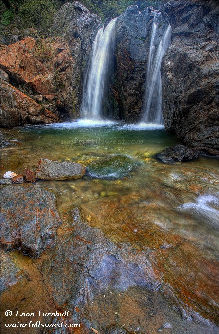
Thunderbird Falls (with mosquito topping)

I prefer my waterfalls without the mosquitoes on top, thank you very much. I also prefer my waterfalls without the hordes of other hikers, and I definitely prefer my waterfalls with a decent view.

Well, I am back from my week long vacation to Alaska, and my first posting is Thunderbird Falls in Chugach State Park near Anchorage. As you may have gathered, it is certainly not the best waterfall I saw on the trip, but it is the first, and that is the only reason I am posting it first. I took tons and tons of photos on this trip, and it will probably take a couple months to go through them all. I saw quite a few waterfalls and quite a bit of wildlife on the trip, though not as much as I had hoped, for either of the two. Still though, it was a fabulous vacation and coming back to 100+ degrees in California was not too pleasing. Alaska is an incredibly beautiful state, kind of a cross between British Columbia, Oregon, and Hawaii. You may think that is odd for me to say that, but the scenery reminded me a lot of BC (with the towering snow-capped mountains, oceans, and swift, clean flowing rivers), and a couple hikes I went on reminded me a lot of Oregon (with the lush greenery), and another hike we went on reminded me a lot of hiking in Hawaii (hot and humid, but with beautiful green vegetation).

I was not too impressed with Thunderbird Falls, for the three reasons I mentioned above in the first paragraph. I did go back to it a second time though, in order to seek out better views (to no avail). I arrived in Anchorage in the early afternoon, had lunch, checked into my hotel, and went to REI to buy bear spray. My wife and kids were already in Alaska, but they were up at Nome for a wedding. Although I would have liked to visit Nome, my work only allowed me to take a one week vacation, so we decided that week would be better spent down at Homer, rather than up at Nome. However, I was able to go a bit early and stay in Anchorage for a couple nights before meeting my family at the airport. My plan was to hit the local waterfalls, as many as I could, and try to find some wildlife as well. Anchorage is not a big city, but it is a very difficult city to drive around in. It is very confusing, the signs are a mess, and there are many 1 way streets. Getting to REI was particularly crazy; even though it is surrounded by 4 streets, there is no way to drive to it on any of them. I suppose the locals have it all figured out, but it took me all of 3 days to get the hang of driving around this city.

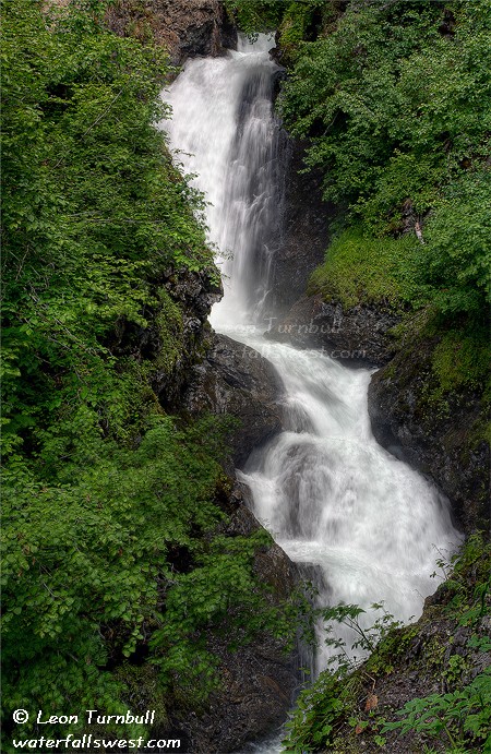
My first stop was the ever popular Thunderbird Falls. I was surprised at the number of people hiking this trail. In fact, I was quite surprised at the number of people out hiking all weekend, even on trails that seemed to be not very interesting. It seems the Alaskans like to hike. Or maybe they were mostly tourists. I’m not too sure. Thunderbird Falls is one of the trails that really is not that interesting. Don’t get me wrong. It is a really nice waterfall, dropping impressively about 70 ft. on the Eklutna River. But there are just no good views of this waterfall. There is an overlook which had a totally obscured view of the falls. Then there is a trail going to the base of the falls, but it does not have a view either. To get a decent view, I had to scramble up a particularly slippery rocky slope that had a steep drop-off down into the river. The first time, I went up the wrong way, and could not get up where I wanted to. When I turned to go back down, I found that I was pretty much trapped. I could not go up or down. I had to slide on my bum back down the slippery slope very carefully, and hoping I could get a solid enough grip on the slippery rocks with my boots so I would not fall. I made it back down with only a muddy bum to show for it. I was not happy with my photos, so I returned again the next day looking for a better viewpoint. This photo was the result. I still was not happy with the viewpoint but I felt I could not get any higher vantage point safely. At least I did not get a muddy bum this time, but I did get quite a few mosquito bites. They were swarming around this spot as I took this shot. They jokingly say that mosquitoes are the state bird in Alaska. I guess they were perhaps twice the size of Californian mosquitoes, but somehow with a statement like that I was expecting them to be a heckuva lot bigger than they were. Either way, I didn’t want to stick around at this viewpoint too long.

No Comments

Stuff

I have a couple tidbits of news to share. First up, is that this photo of Yuba River Falls in Nevada City made the cover of this year’s annual Nevada County Gold Magazine. I was pretty excited about this, being that it is on the cover of the magazine. This is a free magazine that you can pick up at various locations if you live (or visit) Nevada County, so check it out if you are in the area. You can see their website here, but they have not yet updated it yet for this year’s issue).

Also, three of my photos are featured in a new book by Tony Greenfield, called “Waterfalls of British Columbia” (Beaver Falls, Wilson Falls, Cascade Falls). Check it out here.

Thirdly, my photo of Lower Deer Creek Falls was featured on the back cover of the annual report from the Western Rivers Conservancy, a great organization aiming to protect our rivers in the western U.S.A. You can check out their website here.

9 Comments

Wabena Creek Falls

Many of my favourite trails into the North Fork American River canyon are closed right now (Mumford Bar, Beacroft, Sailor Canyon) due to the huge forest fire we had here last year. I wonder when these trails will be re-opened? The effects of the fire are very noticeable as you drive on Foresthill Divide Road from Sailor Canyon to Mumford Bar. It is huge and devastating; burnt trees as far as you can see. The fire came right up to Foresthill Road, but did not cross it. I wish it had crossed it, actually, because the forest on the other side of the road is completely overgrown. Fires are a good thing, they are part of the natural cycle of life that God created. Man often suppresses fire out of necessity, but that is not natural. It may look very ugly right now, but the forest will grow back again.

The forest fire did not affect Wabena Canyon. It is still incredibly beautiful. Stunningly beautiful. I just love the North Fork American River canyon. It is my favourite place on Earth; it is so amazing and pristine, it is so remote, and so difficult to get in to see it. The Wabena Trail is by far the most difficult access point in the entire canyon, and since so very few people hike this trail, it is completely overgrown with brush. It probably needs a fire to clean it out.

Halfway down the trail to the river, you come across Wabena Creek Falls. This is an exceptionally gorgeous waterfall, especially in the spring, and it is about 160 ft. high in total height. Only this top section of the falls can be easily seen, about 80 ft. high. Another huge section drops below this point, but the cliffs in this area are very steep, and the lower falls are not very visible. With more time and energy, I would like to see if I can find a good viewpoint of the lower falls, but it would require a lot of effort and scrambling. Maybe next time, I’ll come back just to Wabena Creek, and not continue on down to the river. By the way, four days after my hike, I am still stiff and sore.
This time around, I noticed quite a bit of poison oak growing even above Wabena Creek Falls. I am sure the oak was not as abundant when I was here 4 years ago, and there was none growing before you got down to Wabena Creek. I read somewhere that global warming is causing poison oak to grow at higher elevations and more abundantly. Whether that is true or not, I don’t know, but it sure seems to be the case in Wabena Canyon. It was completely impossible to avoid touching it on the hike down to the river, and I eventually gave up trying, and just went on through it. I most certainly had poison oak all over myself, and knowing that I will get a rash just by looking at the stuff (read my recent post from Hidden Falls), I was sure that I was in for what would most certainly be the worst poison oak rash I have yet experienced. But I prayed, “Lord, please keep me from getting a rash.” And believe it or not, I did not end up getting any rash at all this time. Sure, I rubbed myself from head to toe with Technu when I got home, but I’ve done that before and it often doesn’t make any difference for me. It must have been a miracle. At least, that’s what I think.

No Comments

The Hike To End All Hikes … Again

The Wabena Falls trail is the steepest and most difficult hike I have ever done. It is steeper than hiking to the top of Yosemite Falls, 2600 ft. elevation loss in only 2 miles. When I first did this hike 4 years ago, while hiking back up I said to myself that I would never hike again after that. That was obviously not true, but I definitely was sure I would never hike the Wabena Trail again. Four years later, I did it again. If you thought I was insane before, now you have proof.

I had been pondering the idea of going back to Wabena Falls all year. Why?? Well, for one thing I wanted to get better photos of it. For another, the Wabena Canyon and North Fork American River is incredibly beautiful. But the primary reason was that I wanted to measure the height of the falls. When I first visited Wabena Falls 4 years ago, I did not own a laser rangefinder, and I roughly estimated its height at about 40 ft. But people in the kayaking community (yes, Wabena Falls has been run in a kayak before) had said they thought it was 80 or 90 ft. high. I found that hard to believe, but certainly my estimate of 40 ft. could have been on the low side. I wanted to find out for sure. When I returned here and eyeballed it, it still did not look all that high to me, maybe 50 ft. or 60 ft. max. Well, the official measurement is now in: Wabena Falls is 65 ft. high.

Once I had made my decision to go back to Wabena Falls this past weekend, I was very excited and looking forward to the trip. But I wasn’t sure if I’d be able to make it there due to lingering snow on the road. Indeed, the Tahoe Natl. Forest website said there was 1.5 feet of snow at Robinson Flat, and that was apparently only a week ago. Man, they need to keep their website more up to date. There was no snow at all at Robinson Flat, and I was easily able to get out to the Wabena Falls trailhead. There was one snow patch still on the road, but I was easily able to plow through it in my SUV. At the end of the day when I got back to this snow patch, there were 5 jeeps sitting on the other side of the patch, with their owners debating whether they could get past it. I just plowed on through and waved to them. I did talk to one guy and told him that I had just finished hiking Wabena Canyon. He obviously had no idea where that was, or he would have said something like: “What? Are you completely insane?”. I think he was just more worried about getting across that snow patch, and if there were any more down the road.

Anyway, back to Wabena Canyon. I started on the trail at about 5:45AM. The weather was perfect, overcast and cool. It was raining when I arrived, but the rain stopped before I started going. The Wabena Trail is incredibly steep, rocky, overgrown with brush, and (on the lower sections) abundant with poison oak. It is very slow going. My memory may be fading in my old age, but I seem to recall it was much easier to negotiate 4 years ago. There was less brush and less poison oak. I got off the main trail a few times, and that made it even more difficult and made it take longer as well. In fact, I may very well be the only person who has hiked this trail in the past 4 years. Within 20 years, I think this trail may be completely impassable, and that would be a mighty shame. I was completely soaked pushing my way through the wet brush by the time I made it down to Wabena Creek and the waterfall there (I’ll post that photo next). Crossing the creek required getting my feet wet. Since my boots were already soaked, I debated whether to just keep my boots on or not, but there were three deep steps through the creek I would have to make, so I wisely took my boots off and went barefoot across. I was already quite tired and only a quarter of the way done. Not a good sign. I made a dumb mistake after crossing Wabena Creek, and that was going high over a talus slide when I should have known to stay low. I realized I had to go straight down to get back to the trail, and since I was quite tired, I was careless, and I took a spill. Thankfully, nothing more than a couple scrapes and bruises. I was not pleased with myself about that. Once back on the main trail, I continued on down to the river. By this time I was quite tired, and the poison oak was now very abundant, growing all over the trail. There was just no way whatsoever to avoid it, so I gave up trying and just pushed my way through it all. But did I get an awful rash? Stay tuned for my next post to find out.

I kinda figured that the North Fork American River would be flowing too fast and deep to cross, so I made the decision early to climb up above Wabena Falls on this side of the river. I probably could have crossed the river without too much trouble, although I’m not sure if I could have gotten right up to the falls on the other side. Anyway, I scrambled up the cliffs through more poison oak, and came to a fabulous overlook of Wabena Falls on the edge of a cliff. The sun had started to come out on my hike down, but God blessed me when I got up to the viewpoint, providing me with cloudy conditions so I was able to get some nice photos of the waterfall. I stayed here for quite some time, enjoying the outstanding view, and resting. I finally mustered up enough energy to start the hike back up the canyon.

2600 ft. is a long way up. Especially when it is essentially straight up the mountain. It took awhile, but I got back to Wabena Creek Falls at about noon, where I ate my lunch and took a long rest. At 1PM, I started up the rest of the way. Thunderclouds had rolled in, and I felt a few drops of rain. I thought I was gonna get dumped on, but again, God cleared away the rain for me. The first part right above Wabena Creek is quite steep, and when I got up that section, my legs all of a sudden were screaming with pain and cramping. Uh oh, I thought, so much for my long rest. The cramping is worse and I haven’t even begun the hardest part of the hike yet. But fortunately, after that initial cramping, my legs calmed down, and I slowly, methodically, made my way up the mountain.

Now you may be thinking that I was once again thinking that this would be the last hike I would ever do, and especially that I would never hike the Wabena Trail again. You would be wrong. I was thinking neither of those things. In fact, I felt quite good hiking up this last steep part of the mountain. Indeed, at one spot near the top, I sat and rested and looked down upon Wabena Creek Falls and the North Fork American River canyon, and I felt sad. I was sad because I realized it may very well be the last time I hike this trail (I’m not getting any younger), and it was just so darn beautiful. Here I was all alone, not a single other soul within miles of me, and I had this incredible view all to myself. The beauty of God’s creation was overwhelming to me. I do want to return here again, and to see this beauty again. Maybe I’ll be back again, someday.

No Comments

Pretty Flowers, Pretty Waterfall

I found these pretty purple (lupine) and orange flowers beside the road at Lower Foresta Falls at Yosemite. I decided to take a photo with the waterfall in the background. I didn’t quite get the focus on the flowers the way I wanted (flower photography is certainly not my specialty), but I think it works fairly well. I did intentionally have the waterfall in the background out of focus, and I accomplished this by using a small aperture setting (f/4) on my camera.

I found another waterfall at Lower Foresta Falls as well. You could see it down the road on a creek that I discovered later was Little Crane Creek (Foresta Falls is on Crane Creek). Little Crane Creek is host to a known waterfall called Little Nellie Falls, and that creek flows down from that waterfall where it joins up with Crane Creek. But it forms another waterfall unexpectedly in the vicinity of Lower Foresta Falls. It is not a big waterfall, but it was worth venturing down the road to see it. That’s when I discovered these flowers just down the road from the bridge at Lower Foresta Falls.

No Comments