Thanksgiving Day. Time: 3:30AM. Event: Alarm Rings. Action: Wake Up. Make coffee. Drive north to meet family for Thanksgiving Day. First stop off at Brandy Creek for a quick morning hike and exploration.
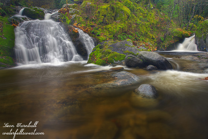
This was how my day shaped up for me. Getting a good solid hike in before eating a big meal is always a good thing. My first stop along Brandy Creek was Lower Brandy Creek Falls (Rich Gulch Falls), which I have not stopped at in a very long time. Though I have called it Lower Brandy Creek Falls in the past, the waterfall is not actually on Brandy Creek but on Rich Gulch. The small 10 ft falls on the right is Brandy Creek. The larger one on the left (which I measured as being 18 ft high) is Rich Gulch.
It is a steep descent from the trail down to creek level but is not really too difficult. I quickly decided the best viewpoint was from the other side of the creek and since the creek was flowing higher due to recent rain, that meant getting wet. I donned my water shoes and crossed the creek. It was cold. Fortunately, there was a nice large rock on the other side to stand on so I did not have to shoot from in the creek.
After spending quite a lot of time here shooting this lower falls I continued on up the trail as I still had some time before Thanksgiving lunch with family in Redding. Not to the upper falls though. I was in an exploring mood for searching out new waterfalls on Brandy Creek. Did I find any? Stay tuned.
Posted in Northern CA, Redding, Waterfalls by leapin26: November 28, 2011
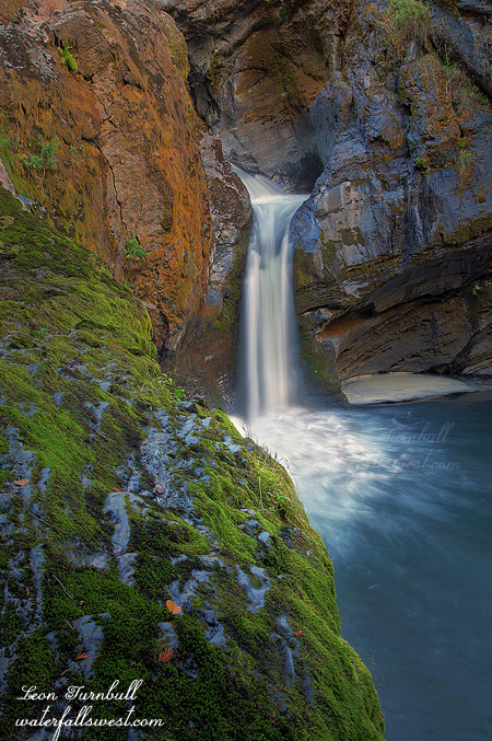
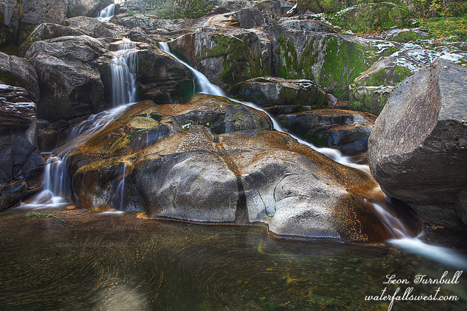
This is Upper Sheep Creek Falls in Northport Washington, 21 ft. high. It is tucked in a pretty little gorge, and certainly a very interesting little waterfall.
It is an easy hike up from the lower falls to the upper falls, but it was a bit too far for Nekoda to walk (though actually, she could have done it easily, I think). I tried to entice Jadon to come with me but he just did not want to come, and instead all 3 of them stayed back at the car, and I just took the dog, Kaya, with me. At the end of the road, I knew I was right beside the waterfall, but I could not see it. It was a very steep drop down to the creek, and I wondered how I could ever get down there. There was a path over to the edge, so I followed it, but it took me right to the cliff above the waterfall, and no descent was possible there. There was an old mining structure which looked rather unstable to walk upon, no dice. I could not even get a view of the falls. I retreated. It was Kaya who found the “proper” trail down on the way back, I would have missed it completely if not for her. She is such a smart dog. But also a strange one. She was whipping down the trail like nobody’s business, then she came to one spot which was particularly tricky (or so she determined), and she would not would not continue. I could not entice her down this one spot no matter what. So instead, I went back up to her, and found a different way down (which I thought was much worse), and she had no problems going down this different, steeper, route. Silly dog. We got to the bottom, but could not get all the way down to creek level. There was a ledge you could walk out close beside the waterfall, but it was slippery and I did not want Kaya to wander around too close to the edge while I was talking photos (she has almost fallen over waterfalls in the past), so I tied her up for my own peace of mind, while I took some photos of this little gem.
Posted in Washington, Waterfalls by leapin26: November 20, 2011
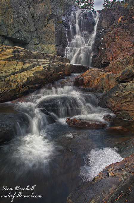
This is Upper Glen Alpine Falls, 32 ft. high. In the spring, it is a little spitfire, roaring down the canyon. But in the Fall, it is actually still quite a pretty little waterfall. Since it is pretty much a straight drop, it does not need a lot of water to look good, so even with very little flow in the creek, it is still lovely to visit. Compare that to Lower Glen Alpine Falls, which was not even worth seeing (on the same creek with the same amount of water flow). It is also quite easy in the Fall to get right down in front of the waterfall in the middle of the creek; I would not be able to shoot from here in the Spring, that is a certainty.
Posted in Lake Tahoe, Northern Sierra, Waterfalls by leapin26: November 16, 2011
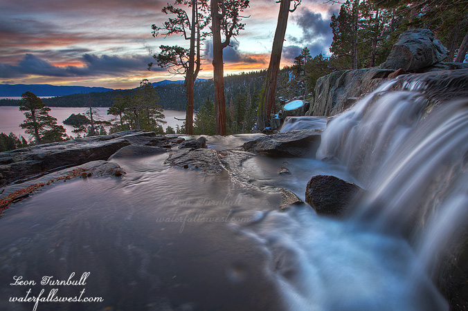
I have shot sunrise at Eagle Falls before. The well known location from the top of the waterfall overlooking beautiful Emerald Bay, made famous by the late Galen Rowell. Many others have photographed from this spot since Rowell, and many have taken fabulous photos from this location, but for me, I have not ever taken a photo that I really really liked. I am a lot closer to it now.
I drove up to Lake Tahoe early early Saturday morning. When I started out, I was not sure where I was going to end up. The forecast said overcast in the morning, and it sure looked that way as I drove up Hwy 50. When I got to the summit, I stopped. Got out of my car. Looked at the sky. I saw lots of clouds. I saw stars. It seemed that there was a possibility at least of a decent sunrise at Tahoe, so I made my decision. Eagle Falls. It was a good decision.
There was no one else at Eagle Falls as I drove up. I saw one other photographer shooting Emerald Bay, but he was on the wrong side of the bay for a sunrise shoot. I can’t imagine he got any decent shot from where he was. There was definitely a break in the overcastness on the other side of the lake. It looked like a sweet sunrise was definitely on the agenda. Thank you Lord.
When the water level is lower at this time of year, your composition choice here is extremely limited. If you want to include any part of the water or falls, this is essentially the only option. But it does work, and it works quite well. Nonetheless, I kind of want to come back in the spring and try again. For an even sweeter sunrise, and an even sweeter waterfall. Sounds like a plan.
Posted in Lake Tahoe, Northern Sierra, Waterfalls by leapin26: November 12, 2011
Now that is what I am talking about.
Well it was not Plan A. And it was not Plan B. But Plan C worked out pretty fine. I wanted to head on over to the Eastern Sierra on Saturday. The big waterfall at June Lake is flowing right now, and I had hoped to get up to the base of it. However, due to the most recent snow storm, the road over Monitor Pass is now closed. With luck, it will re-open this week and I can try again next weekend, but there is a good chance it will now be closed for the rest of the winter. Plan B was to head over to the Yosemite area, where I know of certain waterfalls that also are flowing well right now. But the weather forecast was calling for a sunny day on Saturday, and I did not want to drive all the way out there, and not be able to get good photos of them. I really need a cloudy day for that trip. As it turned out, it was a cloudy day on Saturday! What the hey? I could have done Plan B after all. Darn weather forecasters.
Plan C was to do an easy hike back up to Alder Creek Falls near Kyburz, hoping to get down to the bottom of it. It was a very cold morning, and there was some snow on the ground, though not too much. I got to the top of the waterfall easily enough. But it is very steep on the one side of the creek, and not possible to get down to the base of the falls. I was able to cross the creek, however, at the top of the waterfall, and work my way down on the other side. If the creek was flowing any higher, I would not have been able to do this. It was a bit sketchy in a couple places as it was. Nonetheless, I made it down, and I was happy to do so. This would be a fantastic place to be in the spring, but crossing the creek at the top of the falls will not be a possibility in any way, shape, or form. Hmmm, what to do, what to do.
Posted in Northern Sierra, Waterfalls by leapin26: November 5, 2011
