
MINI ME
The planning was perfect. The execution was perfect. The result not so much.
It’s been awhile since I’ve been out hiking and waterfallin’. I normally do not hike much in the summer. The heat and the bugs do not agree with me, and eating too much ice cream tends to mean I gain weight over the summer. It was 100 degrees on Friday, but dropping by over 10 degrees for Saturday. I thought it would be nice and cool in the mountains on Saturday morning. Yes waterfall madman, it is time to get back at it. This would be a perfect day to hike, and a perfect time to try to get to Mini Curtain Falls on the North Fork Stanislaus River.
Yes we are in a four year drought. Yes there is water flowing on the North Fork Stanislaus River. This river is a controlled river though, and it flows year round. Normally, however, it has about twice the flow at this time of year (give or take a little bit). So yes, the drought is affecting this river as well, but 110 cfs is still pretty good for waterfallin’.
I planned my route on Google Earth and I did an impeccable job of it (if I may say so). There is no trail down to the river. It is a 1300 ft. descent from the road, down through the forest, following bear trails and not much else. Lots of brush (but not too bad), and steep. Very very steep. This is my first waterfall hike in quite a while, and I guess I must be out of hiking shape. I almost did myself in on this one. I have been working out over the summer, but that is not the same as hiking up and down steep mountains. This one was a doozy.
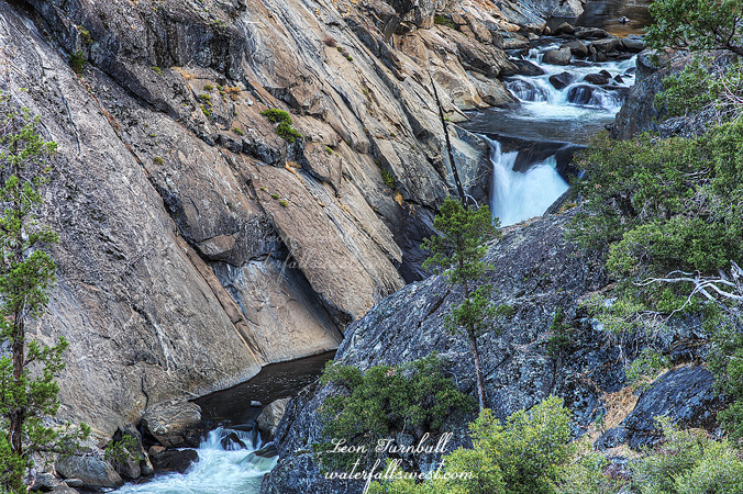
I was quite certain that I would not be able to get up to the falls from along the river, due to the sheer cliffs on each side. I did go all the way down to take a gander, and yes I was correct. There was no way to get up close to it. That meant I had to climb up the cliff to where I could get a long distance view of the falls from a ridge. Google Earth shows a clear view of the falls from here, so I was fairly certain that IF I could get up there, then I would have a grand view of the falls. Wrong. I climbed up on the ridge without much difficulty (though it was not easy by any stretch of the imagination), and I got to the exact point that I had planned. I was even able to go further than I had planned. However, there was a big huge rock in the way. This rock is not showing any blockage of the falls on GE. It is a clear viewpoint. I even checked again when I got home. Nonetheless, the rock was there. I could only see the top half of the waterfall. I tried to find other vantage points. I made my darnedest effort, and everything I could do, but there was nothing doing. This shot was the best view I could find. The height of the falls is about 20 ft. (I suspect even a bit more than that), but the entire thing is not to be seen.
By this time I was quite tired from all the scrambling around. I still had to climb 1300 ft. out of the canyon. I took a rest (many rests), and eventually I made it back up to my car (barely, perhaps). I hope my body behaves a bit better on future hikes this winter. I have a ton of big hikes planned, and hopefully next time with better results.