
LOST!
Who’s the madman? Yes, that is me. Who can find hidden waterfalls in the middle of nowhere that no one else has been to? Me, again. Well, I can’t quite take full credit on this one. It was waterfallswest friend Trailscout that found this on Google Earth, and told me about this falls on Lost Creek, though she has not been to it yet. How did I miss this one in my study? I scoured Google Earth and the USGS Topo Maps in this area, but somehow missed it, but it was there and it sure looked like a good one on GE. I had planned to go in the spring, but with the recent rain and before too much snow fell, it seemed like now would be as good a time as any.
It is a very long drive out here. Basically, you drive to the end of the world, then go a little further, and then get out of your car and hike another 4 miles. I probably could have driven some of those 4 miles, but there was a bit of snow and I felt like hiking anyway.
Thankfully, I fixed my GPS. I was going to order a cheap SD card just to see if that was the problem (before buying a new GPS), and when I looked at the picture of the SD card on-line, I saw a “lock” switch on it. I thought to myself, “no way”. I took out my old SD card and looked at it, and saw that it was in the lock position! This is why the GPS could not write any data to the card! I flicked the switch, and voila! The GPS and card are now working fine. It makes no sense, however, because I NEVER take the card out of the GPS, so how could the switch possibly have been changed?!?! Little gremlins ?
It is a good thing it is working now, otherwise I would have been completely lost. I started down the road and realized I needed to turn off down another drainage and road. Except there was no road! There was a very overgrown drainage that there is no way I could have navigated down. Looking at my map, I saw another possible road to take. It would add about 1.5 miles (1 way) to the hike, but I thought I had plenty of time so off I went. At first, this other road was very overgrown, with many fallen logs. I was about to turn back, then I noticed a light at the end of the tunnel, and the road opened up. From there on it was easy. Until, that is, I came to the end of the road, just above the waterfall.
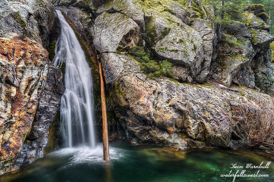
It is a steep descent from here, there is no trail, and a lot of brush (but no poison oak!). You are descending down to the creek beside a seasonal stream, which had a little bit of flow. Thankfully, not much flow because there was one little section where I had to go down right in the middle of the stream, because it was too steep on both sides of it. The only way to continue was to go right down the stream bed. It was very slippery and I had to be extremely careful. It was short, though, and once I got by the steep sections, I was able to get all the way down to the main creek. The waterfall was out of sight and around the corner. I could not even hear it yet. In order to see it, I had to cross the creek. I was able to rock hop across it, but it was difficult, and the rocks were very icy and slippery. I made it across, then I climbed up the icy rocks and logs on the other side, then across a sketchy talus slide, and there it was! An incredibly gorgeous 38 ft. high falls dropping into a magnificent emerald green pool. I was lost in another world. Such beauty. Such allure. Such grace. And who has ever seen this one or heard about this one before?
For more info on this waterfall, see my website:
https://www.waterfallswest.com/index.php#recent