|
|
Easy |

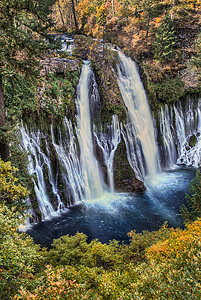
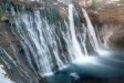
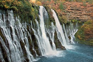
Image 1 of 6; Click arrow to scroll or click image to enlarge |
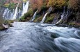
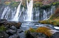
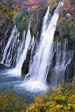
Location: Burney, McArthur Burney Falls Memorial State Park, Shasta County Stream: Burney Creek Alternate Names: Height: 129 ft. Access:     Distance: 1 mile (loop) or 2.4 miles (loop) Elevation: 2900 ft. (+/- 200 ft.) Season: year-round Form:  Lat/Long:41.01083, -121.65167 Directions:Along Hwy #89, at McArthur Burney Falls Memorial State Park, near Burney. From Hwy #299 junction 5 miles east of Burney, turn north on Hwy #89 and drive 5.9 miles to park entrance. There is a $8 parking fee. |


9 Miles N Burney CA (Elev. 3054 ft)
TodayA 50 percent chance of showers, mainly after 1pm. Mostly cloudy, with a high near 57. West southwest wind 8 to 15 mph, with gusts as high as 23 mph. New precipitation amounts of less than a tenth of an inch possible.
Tonight
A chance of showers before 11pm, then a slight chance of showers after 3am. Mostly cloudy, with a low around 42. West southwest wind 9 to 14 mph, with gusts as high as 21 mph. Chance of precipitation is 40%. New precipitation amounts of less than a tenth of an inch possible.
Friday
Showers likely, with thunderstorms also possible after 11am. Patchy fog between 8am and 9am. Otherwise, mostly cloudy, with a high near 56. West wind 7 to 9 mph. Chance of precipitation is 60%. New rainfall amounts between a tenth and quarter of an inch, except higher amounts possible in thunderstorms.
Friday Night
Areas of frost after 3am. Otherwise, partly cloudy, with a low around 34. West wind 5 to 10 mph becoming light and variable after midnight.
Saturday
Areas of frost before 8am. Otherwise, mostly sunny, with a high near 64. Calm wind becoming west 5 to 7 mph in the afternoon.
Saturday Night
Partly cloudy, with a low around 39.
Sunday
Sunny, with a high near 66.
Sunday Night
Mostly clear, with a low around 40.
Monday
Sunny, with a high near 67.
Monday Night
Clear, with a low around 37.
Tuesday
Sunny, with a high near 70.
Tuesday Night
Mostly clear, with a low around 40.
Wednesday
Mostly sunny, with a high near 66.
| Clark Creek Falls | 2.16 miles | |
| Rock Creek Falls | 3.43 miles | |
| Pit River Falls | 9.68 miles |
| Shasta Cascade | Waterfalls Home Page |