|
|
Strenuous |

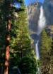
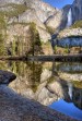
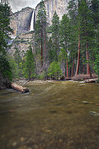
Image 1 of 6; Click arrow to scroll or click image to enlarge |
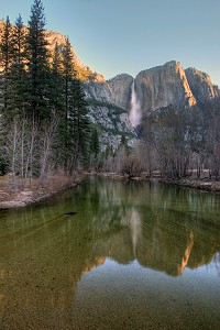
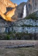
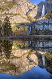
Location: Yosemite Village, Yosemite National Park, Mariposa County Stream: Yosemite Creek Alternate Names: Height: 1430 ft. Access:     Distance: 7 miles (RT) (hike) Elevation: 4000 ft. (+2700 ft.) (hike) Season: Mar-Jul Form:  Lat/Long:37.75632, -119.59683 Directions:The trailhead to Upper Yosemite Falls is at Sunnyside walk-in campground on Northside Drive, just a little west of Lower Yosemite Falls. If you can find one of the very few legal spaces, park at Yosemite Lodge (across from Lower Yosemite Falls) and walk up the road to the trailhead; otherwise you will need to take the shuttle from Yosemite Village. |


Yosemite Valley CA (Elev. 4760 ft)
This AfternoonA 10 percent chance of showers and thunderstorms. Mostly sunny, with a high near 71. West wind around 10 mph.
Tonight
Mostly clear, with a low around 46. North northwest wind around 5 mph becoming northeast after midnight.
Saturday
Partly sunny, then gradually becoming sunny, with a high near 73. Light and variable wind becoming west southwest 5 to 10 mph in the afternoon.
Saturday Night
Mostly clear, with a low around 49. East wind around 5 mph becoming north in the evening.
Sunday
Sunny, with a high near 78. Northeast wind around 5 mph becoming west southwest in the morning.
Sunday Night
Mostly clear, with a low around 51. West wind around 5 mph becoming calm in the evening.
Monday
Sunny, with a high near 77. East northeast wind 5 to 10 mph becoming west southwest in the afternoon.
Monday Night
Mostly clear, with a low around 48. West southwest wind 5 to 10 mph becoming east in the evening.
Tuesday
Sunny, with a high near 70. South southeast wind 5 to 10 mph becoming west southwest in the morning. Winds could gust as high as 15 mph.
Tuesday Night
Partly cloudy, with a low around 45. West wind 5 to 10 mph becoming east in the evening. Winds could gust as high as 15 mph.
Wednesday
A 20 percent chance of rain. Mostly sunny, with a high near 66. North wind 5 to 10 mph becoming west southwest in the morning.
Wednesday Night
A 20 percent chance of rain. Partly cloudy, with a low around 42. Northwest wind 5 to 10 mph, with gusts as high as 15 mph.
Thursday
Partly sunny, with a high near 61. West southwest wind 5 to 10 mph, with gusts as high as 15 mph.
| Lower Yosemite Falls | 0.35 miles | |
| Lehamite Falls | 0.99 miles | |
| Royal Arch Cascade | 1.46 miles | |
| Staircase Falls | 1.87 miles | |
| Sentinel Falls | 2.17 miles | |
| Horsetail Falls | 2.79 miles | |
| Ribbon Falls | 3.08 miles | |
| Snow Creek Falls | 3.34 miles | |
| Vernal Falls | 3.45 miles | |
| Illilouette Falls | 3.47 miles | |
| Tenaya Falls | 3.55 miles | |
| Silver Apron Falls | 3.56 miles | |
| Bridalveil Falls | 3.82 miles | |
| Nevada Falls | 4.05 miles | |
| Widows Tears | 5.06 miles | |
| Silver Strand Falls | 5.26 miles | |
| Lower Pywiack Cascade | 5.76 miles | |
| Pywiack Cascade | 6.15 miles | |
| Merced River Falls | 6.32 miles | |
| Tamarack Falls | 6.49 miles | |
| Cascades | 6.49 miles | |
| Tioga Pass Falls | 6.51 miles | |
| Wildcat Falls | 6.78 miles | |
| Bunnell Cascade | 6.79 miles | |
| South Fork Tuolumne Falls | 7.11 miles | |
| Clark Fork Falls | 7.33 miles | |
| Upper Tenaya Creek Falls | 7.63 miles | |
| Grouse Creek Falls | 8.29 miles | |
| Echo Creek Falls | 8.57 miles | |
| Avalanche Creek Falls | 8.92 miles | |
| Silverlace Falls | 9.06 miles | |
| Foresta Falls | 9.72 miles |
| High Sierra | Waterfalls Home Page |