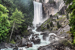
| Vernal Falls | Moderate |

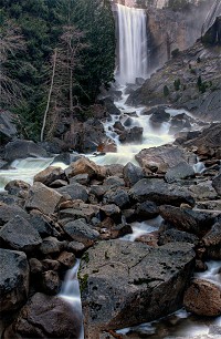
Image 1 of 5; Click arrow to scroll or click image to enlarge |
Location: Yosemite Village, Yosemite National Park, Mariposa County Stream: Merced River Alternate Names: Height: 317 ft. Access:   Distance: 4.4 miles (RT) Elevation: 4000 ft. (+1000 ft.) Season: Apr-Jul Form:  Lat/Long:37.72743, -119.54377 Directions:On Southside Drive, drive to Curry Village and park. Then take the free shuttle to Happy Isles, stop #16. Start walking up the paved trail to the Vernal Falls bridge. |


2 Miles SSW Yosemite CA (Elev. 6365 ft)
This AfternoonMostly sunny, with a high near 59. West wind 5 to 10 mph.
Tonight
Mostly cloudy, with a low around 42. Calm wind.
Friday
Mostly cloudy, then gradually becoming sunny, with a high near 58. Light and variable wind becoming west 5 to 10 mph in the afternoon.
Friday Night
Mostly clear, with a low around 42. Calm wind.
Saturday
Mostly sunny, with a high near 59. Light and variable wind becoming west 5 to 10 mph in the afternoon.
Saturday Night
Clear, with a low around 44. West wind 5 to 10 mph becoming light and variable in the evening.
Sunday
Sunny, with a high near 63. East northeast wind 5 to 10 mph becoming west southwest in the morning.
Sunday Night
Mostly clear, with a low around 45. West wind 5 to 10 mph becoming east northeast in the evening.
Monday
Sunny, with a high near 62. East northeast wind 5 to 10 mph becoming west southwest in the morning.
Monday Night
Mostly clear, with a low around 43. West southwest wind 5 to 10 mph becoming east after midnight.
Tuesday
Sunny, with a high near 56. East wind 5 to 10 mph becoming west southwest in the morning. Winds could gust as high as 15 mph.
Tuesday Night
Partly cloudy, with a low around 40. West southwest wind 5 to 10 mph, with gusts as high as 15 mph.
Wednesday
A 20 percent chance of rain. Mostly sunny, with a high near 50. West southwest wind 5 to 10 mph, with gusts as high as 15 mph.
| Silver Apron Falls | 0.12 miles | |
| Nevada Falls | 0.62 miles | |
| Illilouette Falls | 1.31 miles | |
| Staircase Falls | 1.74 miles | |
| Royal Arch Cascade | 2.10 miles | |
| Tenaya Falls | 2.36 miles | |
| Snow Creek Falls | 2.66 miles | |
| Sentinel Falls | 2.81 miles | |
| Lehamite Falls | 3.03 miles | |
| Lower Yosemite Falls | 3.25 miles | |
| Merced River Falls | 3.40 miles | |
| Upper Yosemite Falls | 3.45 miles | |
| Clark Fork Falls | 4.00 miles | |
| Bunnell Cascade | 4.12 miles | |
| Lower Pywiack Cascade | 4.78 miles | |
| Horsetail Falls | 4.94 miles | |
| Pywiack Cascade | 5.07 miles | |
| Bridalveil Falls | 5.52 miles | |
| Ribbon Falls | 5.58 miles | |
| Echo Creek Falls | 5.94 miles | |
| Silverlace Falls | 6.23 miles | |
| Widows Tears | 6.63 miles | |
| Upper Tenaya Creek Falls | 6.80 miles | |
| Silver Strand Falls | 6.86 miles | |
| Tioga Pass Falls | 8.48 miles | |
| Lower Washburn Lake Falls | 8.68 miles | |
| Cascades | 8.98 miles | |
| Tamarack Falls | 9.13 miles | |
| Wildcat Falls | 9.20 miles | |
| Upper Washburn Lake Falls | 9.53 miles | |
| Sacred Pool Falls | 9.97 miles |
| High Sierra | Waterfalls Home Page |