I was hoping my son would come along on my hike this weekend, but he was sick so he wimped out. I was sick too, but I am not one to wimp out so easily. I don’t blame him though. He was sicker than I was. In a way, it’s a good thing he didn’t come. The road to where I was planning to hike was blocked by a huge tree fallen across the road. Well that pretty much settled it. Plan A was out of the question. I could have still hiked to the waterfall, but it would have been 12 miles round trip, and I was not up for a long hike. Plan B it is then.
I drove into Lassen Volcanic NP. It was extremely windy and extremely cold. The thermometer was at 20 degrees. There was a large group of people getting ready to hike up Lassen Peak – at least I assume that is where they were going; it is somewhat popular in the winter to hike up there and ski down. But the snow was complete ice today, and with the awful cold and wind, it didn’t seem like a smart thing to do. Especially the skiing down part. That would be suicide.
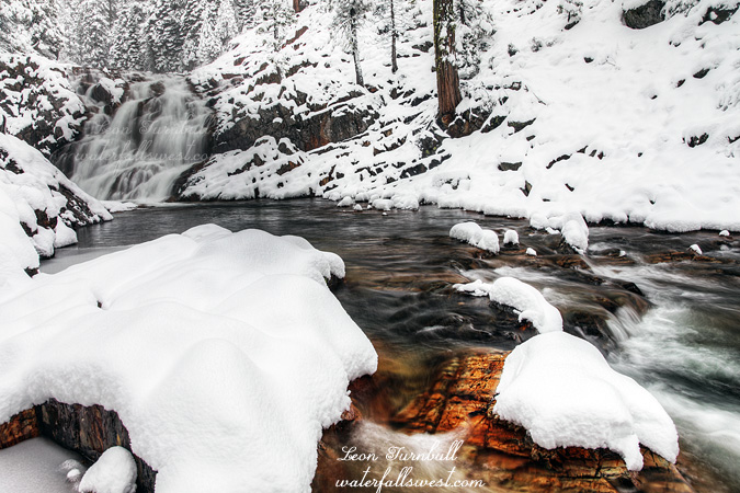
Well after using the facilities, I drove back out to the Brokeoff trailhead where I found another early morning riser, this crazy one was planning to hike up Mt Brokeoff. My destination, however, was down, not up. There was quite a lot of snow at this elevation (6500 ft.), and of course it was all ice. I got on my snowshoes and followed the stream downwards, and with the snowshoes on, it was easy enough. There was just one unmarked drainage I had to cross that gave me a lot of trouble. Firstly, the slopes along the creek were steep and icy, and I could not find an easy way down to the creekside. When I finally found a spot to get down, I couldn’t see any way across the creek without getting wet, and I did not want to get wet in this icy cold weather. I took off my snowshoes and with much difficulty, I rock hopped across successfully. On the way back up later, I tried to bypass this creek crossing by going straight up, but it led in a wrong direction, so I eventually had to cross it again anyway, and also with much difficulty. However I did not take my snowshoes off on the way back – crossing on a big log with my snowhoes still on. That was highly entertaining (for the squirrels watching me). That little unnamed creek sure gave me a lot of troubles … but I shouldn’t be too upset with it, because it added quite a lot of flow to my waterfall.
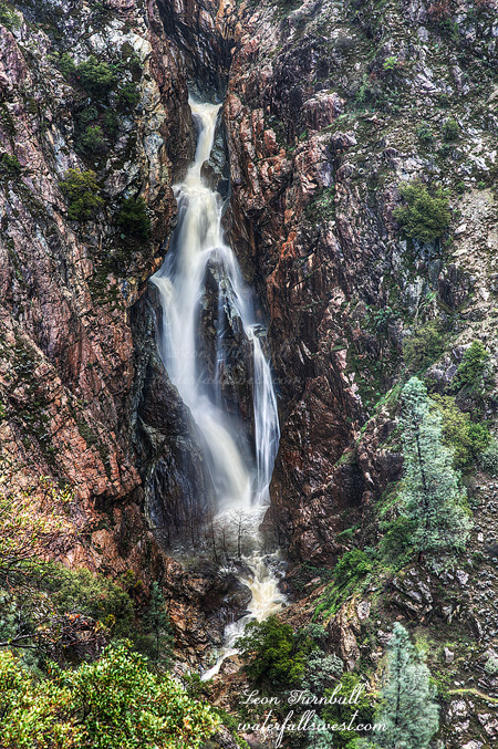
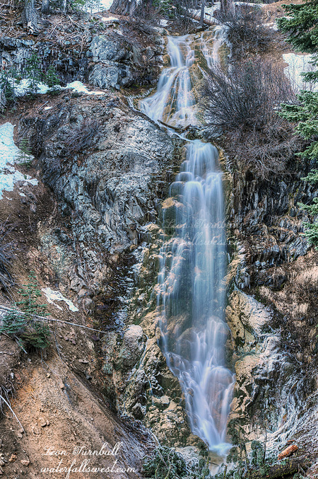
And downwards to the waterfall. When I came to the steep section near the falls, the snow disappeared. That was good because there is no way I could have descended that part on icy snow, period. But without snow, it was easy to do. Unfortunately, I had my winter boots on instead of my hiking boots, and they have worse tread (why didn’t I wear my hiking boots – that was stupid, Leon), but I made it down successfully, without going over the cliff, and that was tricky because the cliffs are crazy steep around here, and the ground crumbly. You sure don’t want to get too close to the edge, but fortunately, there is a fabulous viewpoint of this waterfall that does not require too many crazy cliff hugging maneuvers. And it was gorgeous! I was not expecting to find such a beautiful vertical drop, and to top it off the flow was quite decent (thanks partly to my unnamed creek nemesis). I measured the falls to be 103 ft. high, which makes it the highest vertical drop that I have yet found in Lassen Volcanic NP (Kings Creek Cascades is a bigger falls, but is not vertical). I have to say this is perhaps the most beautiful waterfall in Lassen I have seen, and yet this is another one that no one seems to know about, and I did not find any trace of path or human activity down here. It is an unnamed stream, but it does have good flow in the spring. Winner winner pumpkin eater.
After hiking back up to the snow line, I continued on across the ridge over to West Sulphur Creek. I wanted to see if I could see the upper falls from this side of the canyon. I was not planning to do this initially, but I realized I was pretty close and so I decided to go for it. It was easy enough hiking over to the cliffs above West Sulphur but there is no view of the falls from there, so once again I had to find a way down. I took off my snowshoes again and went down down down. Eventually, I did find a view of that waterfall, but the bottom of it was obscured. Perhaps if I went all the way to the bottom, I could find better views, but there was snow down there and it would have been dangerous, and both the upper and lower falls were already in the sun anyway. I will have to save that one for another time. It was a very marvelous and very cold day in Lassen.