When I was here at Bowman Lake Falls, it was pouring rain, and I got soaked just walking over to the waterfall. It is very difficult to photograph in the rain, and I did not have an umbrella or anything with me (my umbrella broke on a previous hike this spring), but I made do the best I could, using my hat to cover the camera in between shots. I was not able to use my polarizer for this shot because I could not get it dry enough, so this shot is somewhat “rougher” than my usual waterfall shots. Eh, it is not the greatest shot to my liking, but not too bad I guess, all things considered.
Posted in Northern Sierra, Waterfalls by leapin26: June 10, 2012

A little while ago, I took a day trip up on the bad road again. Yes I am talking about the Bowman Lake road, which most certainly has got to be the worst road around. My jaw still rattles for a week afterwards.
It was a rainy overcast day and there were five waterfalls there I was hoping to get to. The main reason I wanted to get to all five of them is because I never want to have to drive up here ever again. I hate this road! Well I only made it to three of them so that means I’m gonna have to go back there again someday. Doh!
It was almost a perfect day for going up to Bowman Lake. I arrived at Faucherie Lake first at sunrise, and I could sense the rain was about to begin. It was not “supposed” to start raining until 10am so I thought I’d have a lot more time. I donned my water shoes and crossed over the lake outlet stream and kept the shoes on for the short hike over to the waterfall at the inlet stream to Faucherie Lake. It was interesting because I could literally hear the waterfall from the parking area. The sound was bouncing off the rock wall at the far end of the lake and then across the lake again to me. It was weird because it made me think there was another waterfall on the far end of the lake. The inlet waterfall is not a big one, only 20 ft high, and the flow was ok, but not strong. It was difficult to find a good vantage point and I was not comfortable climbing around the rocks with only my water shoes on; I settled for a mediocre shot though I don’t really think I could have found a better vantage point anyway.
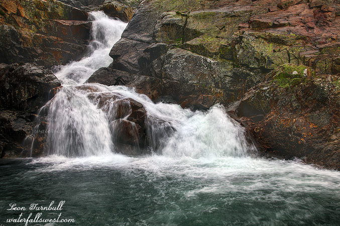
The photo you see here, however, is the second waterfall I went to, Jackson Creek Falls, also about 20 ft high (27 to be precise). This is more of a roadside waterfall, though it requires scrambling down a bit of a steep bank to get creek side. This one is definitely a very pretty waterfall. By the time I got here the rain had started off and on, soon to be just on, but at least the weather kept the mosquitoes away.
After this I went to Bowman Lake Falls which I have been to before but did not have any good photos of it. This requires crossing Jackson Creek which was difficult to just rock hop across. I did not want to get my feet wet so I tossed some big boulders into the stream so I could step across on them. This worked but ended up being pointless because by the time I reached the waterfall I was soaking wet anyway due to the rain, which by now was coming down in earnest. It is not easy taking photos in pouring rain but I tried. I climbed up through the wet bushes to the top of the falls as well to shoot that section and measure it (120 total height if you are interested). By the time I got back to Jackson Creek I had already decided my day of hiking was over so I just splashed through the creek and got back to the car. It was raining and I was already soaking wet and the other two waterfalls would both take a lot of effort to reach in the rain so I decided I would just leave them for another day. Such was my morning at Bowman Lake.
Posted in Northern Sierra, Waterfalls by leapin26: June 6, 2012
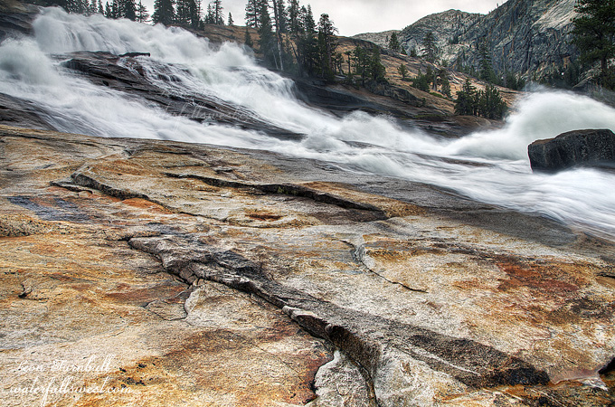
This is 229 ft. high Le Conte Falls on the Tuolumne River. It was not one of my favorites on this hike, but it certainly is impressive. You can see why it is often mistaken for Waterwheel Falls, with the big waterwheel it has of its own in the middle of it.
This waterfall is difficult to photograph, and I had a lot of trouble finding a good angle to shoot it. The waterfall is big and wide and has a fairly shallow angle, and also you cannot see the entire falls from one spot. This was about the best I could come up with.
Posted in Waterfalls, Yosemite by leapin26: June 5, 2012
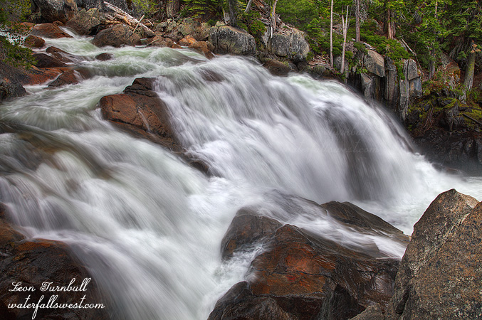
In addition to the five major waterfalls on the Tuolumne River, there are a number of smaller waterfalls, and some of them are significant and not to be overlooked. This is one such waterfall, Lower Waterwheel Falls, which is 32 ft. high. I think most people do overlook this one, and the reason being is that it is so far to hike to, even though it is a very short half mile from Waterwheel Falls. Most people I think just hike to the top of Waterwheel Falls and then turn around, but if you go to the bottom of that huge waterfall, it is very simple to continue down to this lower falls. This was by far the best of the smaller falls on this river. Nonetheless, it is a long 9.6 miles from the Tuolumne Meadows trailhead. It would have been possible to scramble down to the bottom of this falls for a better viewpoint, but I was well out of scrambling mode by the time I got down here. No extra energy was available to do anything requiring that sort of effort, so I just shot this one from the trail (well, slightly off trail).
Posted in Waterfalls, Yosemite by leapin26: June 2, 2012
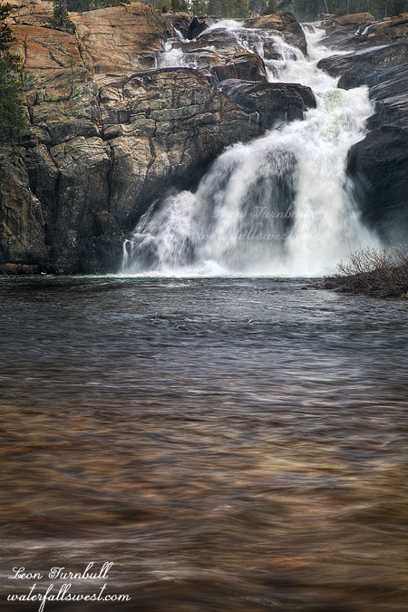
White Cascade was my favorite of all the waterfalls on the Tuolumne River. It is certainly not the biggest (82 ft. high), or the most powerful, but I found it to be the most interesting. I really liked the shape of it, the top half of it cascading steeply down, then the last half plunging off the ledge (losing contact with the bedrock), into a large and inviting pool. It is powerful yet pretty at the same time. It is interesting that it is called a Cascade, because it is not a cascade at all. It is a horsetail waterfall. (compare that to Waterwheel and Le Conte “Falls” which really are cascades – someone messed up on the naming of these waterfalls if you ask me). White Cascade is also called Glen Aulin “Falls”, but the former name is the official name of this waterfall.
My plan was to eat my lunch here at this waterfall on my hike back up, but I literally could not make it that far and had to stop before I got to it. I almost made it, but I came to the lower cascade just below this one, and realized that there was absolutely no way I could make the climb up to the top of the small cascade. I stopped at the bottom of it, and had to lay down for a good half hour to regain my energy so I could climb the little hill. In the meantime, it started to snow harder and it got a lot colder as well. I did not care about that because I could not move. After resting, I ate an apple and part of my sandwich, then decided I could hike up the rest of the way. I stopped, obviously, at White Cascade and took some photos, then continued on up the rest of the way to the top. I still had five miles to get back to the car, and the snow continued on.
Posted in Waterfalls, Yosemite by leapin26: May 30, 2012
