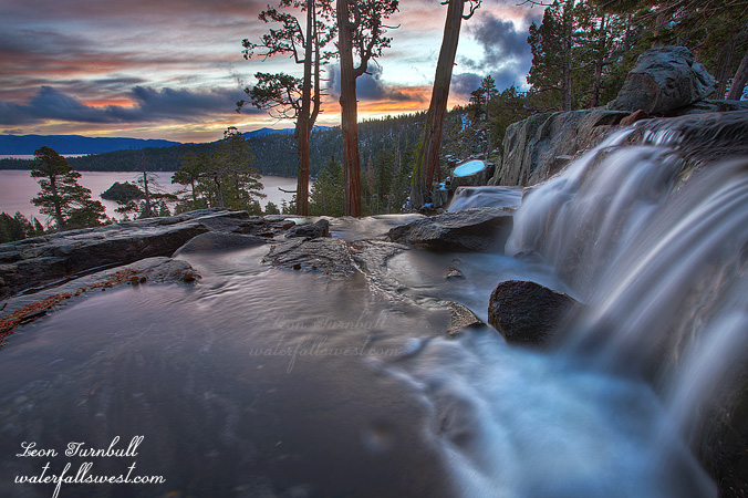
I have shot sunrise at Eagle Falls before. The well known location from the top of the waterfall overlooking beautiful Emerald Bay, made famous by the late Galen Rowell. Many others have photographed from this spot since Rowell, and many have taken fabulous photos from this location, but for me, I have not ever taken a photo that I really really liked. I am a lot closer to it now.
I drove up to Lake Tahoe early early Saturday morning. When I started out, I was not sure where I was going to end up. The forecast said overcast in the morning, and it sure looked that way as I drove up Hwy 50. When I got to the summit, I stopped. Got out of my car. Looked at the sky. I saw lots of clouds. I saw stars. It seemed that there was a possibility at least of a decent sunrise at Tahoe, so I made my decision. Eagle Falls. It was a good decision.
There was no one else at Eagle Falls as I drove up. I saw one other photographer shooting Emerald Bay, but he was on the wrong side of the bay for a sunrise shoot. I can’t imagine he got any decent shot from where he was. There was definitely a break in the overcastness on the other side of the lake. It looked like a sweet sunrise was definitely on the agenda. Thank you Lord.
When the water level is lower at this time of year, your composition choice here is extremely limited. If you want to include any part of the water or falls, this is essentially the only option. But it does work, and it works quite well. Nonetheless, I kind of want to come back in the spring and try again. For an even sweeter sunrise, and an even sweeter waterfall. Sounds like a plan.
Posted in Lake Tahoe, Northern Sierra, Waterfalls by leapin26: November 12, 2011
Now that is what I am talking about.
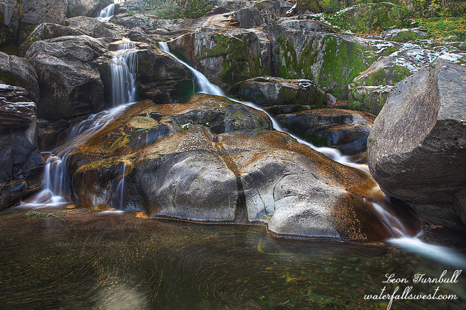
Well it was not Plan A. And it was not Plan B. But Plan C worked out pretty fine. I wanted to head on over to the Eastern Sierra on Saturday. The big waterfall at June Lake is flowing right now, and I had hoped to get up to the base of it. However, due to the most recent snow storm, the road over Monitor Pass is now closed. With luck, it will re-open this week and I can try again next weekend, but there is a good chance it will now be closed for the rest of the winter. Plan B was to head over to the Yosemite area, where I know of certain waterfalls that also are flowing well right now. But the weather forecast was calling for a sunny day on Saturday, and I did not want to drive all the way out there, and not be able to get good photos of them. I really need a cloudy day for that trip. As it turned out, it was a cloudy day on Saturday! What the hey? I could have done Plan B after all. Darn weather forecasters.
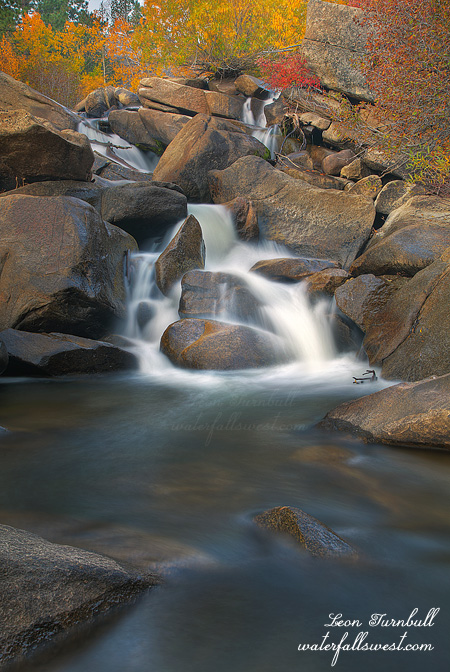
Plan C was to do an easy hike back up to Alder Creek Falls near Kyburz, hoping to get down to the bottom of it. It was a very cold morning, and there was some snow on the ground, though not too much. I got to the top of the waterfall easily enough. But it is very steep on the one side of the creek, and not possible to get down to the base of the falls. I was able to cross the creek, however, at the top of the waterfall, and work my way down on the other side. If the creek was flowing any higher, I would not have been able to do this. It was a bit sketchy in a couple places as it was. Nonetheless, I made it down, and I was happy to do so. This would be a fantastic place to be in the spring, but crossing the creek at the top of the falls will not be a possibility in any way, shape, or form. Hmmm, what to do, what to do.
Posted in Northern Sierra, Waterfalls by leapin26: November 5, 2011
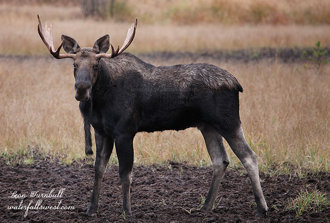
I grew up in Rossland, British Columbia. I never once saw a moose there. I never once even heard of moose being around here (though my memory is rapidly fading in my old age).
So here we are, my brother in law and I, driving out to Nancy Greene Lake one day to do some mtn biking. As we passed the lake I saw a big animal off in a marshy area which sure as heck looked like a moose. Impossible, I thought. He was driving pretty fast, however, and I did not get a good look. Yet I could not think of what else it possibly could have been. Both Lynal and my mom confirmed that there is moose in the area. What? Is this a recent development? Could this really be possible?
The next morning I pulled my wife out of bed and dragged her up to the same area. Sure enough the moose was there. Three big boys in fact were there. We walked as quietly as we could down to the marshy area (which was not too quiet on the loose gravel road) and managed to get very close to them, within a hundred feet or so. They were watching us very closely but they did not move off and we stayed there a long time watching them with me shooting tons of pics. It was a fantastic experience, one of the best moose experiences I’ve had (second only to the ones we paddled past very closely to on the Bowron Lakes). After quite awhile, we decided to finally leave them alone and went back to the car, pleased as punch.
So why are there moose in Rossland now? My unconfirmed theory is that moose (and grizzly bears as well) have moved back into this area now after a long absence. It makes sense. With moose there will be grizzly bears also. There are grizzly and moose now back in northern Oregon as well. I love it. Now if only these animals would move back into northern California I would be ecstatic. Maybe some day.
Posted in British Columbia, Wildlife by leapin26: October 27, 2011
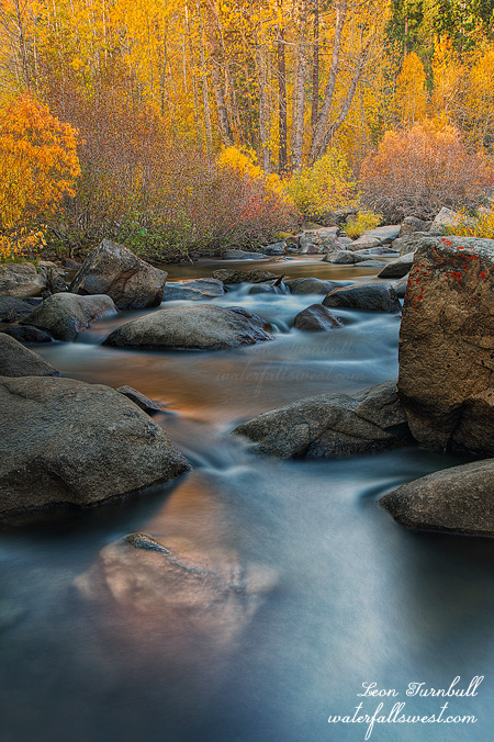
The sun came up quickly in Hope Valley as I was photographing the waterfall on the West Fork Carson River. I knew it would be and that I would not have much time to shoot.
I made my way downstream looking to get at least one more shot of the river and the fall color around it. I found this spot which looked promising and (again) I hopped out on boulders into the middle of the river. You sure couldn’t do that in the spring (but then, there is no fall color in the spring either – LOL).
This image is a blend of two shots. I wanted a super long exposure on the water to give it a real smooth look. But in that exposure the trees were blowing around too much and I did not like how it looked. Fortunately I had an exact image but with a shorter exposure, in which the leaves were not blowing as much. I combined the two in Photoshop … and voila!
Posted in Fall Color, Lake Tahoe, Northern Sierra by leapin26: October 27, 2011
Fall Color and Waterfalls. That is what I like. That is what I want. The only trouble is, gorgeous fall color around waterfalls is hard to come by in California. Usually by this time of year, most waterfalls are dry or just a trickle, and I do not know of too many waterfalls that have fall color around them anyway.
I had heard from certain unnamed sources that the color was at peak on the west side of the Sierra Nevada, so I called my friend Rob and off we went at 5:30AM to Hope Valley. It is very late in the year for Autumn colors here. Rob had figured he had already missed it by a few weeks. But not so. Indeed, we picked the perfect day to head up into the Sierra. Hope Valley was definitely at peak for color. Gorgeous Aspens in bright yellow and orange. It was perhaps the best I have ever seen it here.
I dropped Rob off at Sorensen’s Resort, as he did not want to shoot the waterfall. But I did. I was not sure if there was actually any color around this waterfall and along the river here, but when I arrived I could see that there was some. I have a lot of troubles shooting colorful Aspen trees if there is not any water. Finding a good, stellar composition of Aspen trees is extremely difficult (for me, anyway). But if there is water, I am good to go. Water is my thing. Colorful trees abounded along the West Fork Carson River, and with the recent storm of a couple weeks ago, we had a bonus. The waterfall was actually flowing. Sweetness! I made my way down to the base of the falls, hopping along rocks until I got into the middle of the river, and I found yellow Aspen goodness looking down on me from the top of the falls. I had my colorful waterfall shot after all.
The sun came up quickly but after shooting the waterfall I took a few more shots of the river further downstream, then I went back to find Rob. He was waiting patiently at the Resort for me, going stir crazy from the tempting smell of breakfast cooking. I told him we had to go on one quick hike before breakfast, which we did, though not finding anything worth mentioning on that hike, which meant I had to pay for breakfast since I dragged him on that semi-useless hike. But I was glad to pay. The food was good, though only lukewarm and the service was not so good.
Sorensens Resort has a lot of photo prints on display, many from a photographer named Tony Rowell, son of the late great Galen Rowell. The lady at the resort said his prints sell very well there, but I just kind of wonder about that. I was not too impressed with a lot of them, which were taken with boring cloudless skies. What is so great about that, I wonder? Is he just selling so many prints because of his name? And why do the ones that are so blah looking sell the best? Rob said that when he was at Elizabeth Carmel’s gallery in Truckee, and talking to one of the workers there, he was told the best selling of her prints he thought were just, again, blah and boring. Are we missing something here, Rob and I wondered? Why did the lady at Sorensens Resort look at us so strangely when we told her we were done photographing for the day as the light was now bad? Should we be photographing during the middle of the day when the light is so flat and harsh? Is that what people want to buy? Hmmm ….
Ah well, we sure did have a gorgeous and fantastic morning up at Hope Valley.
Posted in Lake Tahoe, Northern Sierra, Waterfalls by leapin26: October 23, 2011
