Nemesis

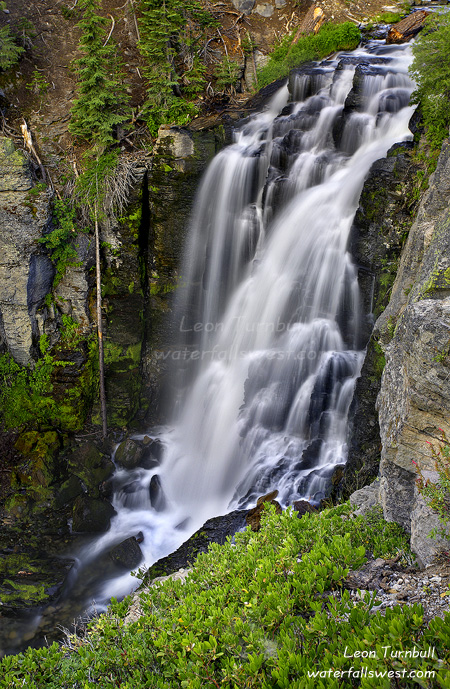
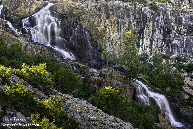
Finally. This one has been my nemesis for a couple years now. And after a couple tries, I was finally able to get to it. This is Eagle Lake Falls at Lake Tahoe. It is 174 ft. high, and it is extreme spectacular-ness.

Now … I suspect that most people have never heard of this waterfall before at Lake Tahoe. Eagle Lake Falls? What the heck? Everyone (and I mean everyone) knows about Eagle Falls at Emerald Bay. It is one of the most photographed waterfalls in California. Most people would also know about Upper Eagle Falls as well. But there is another waterfall on the same stream, and this one is actually bigger than Lower Eagle Falls (which is 140 ft. high).  I want to even say that this waterfall is better than Lower Eagle Falls, but I will refrain from saying that for now.

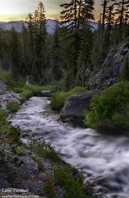
I would say that the vast majority of visitors to Eagle Falls, only visit the Lower Eagle Falls, and perhaps the Upper Eagle Falls. Only a fraction venture above the bridge at Upper Eagle Falls, and visit Eagle Lake. And only a fraction of that fraction venture further than Eagle Lake. But there is a whole world of exploring to be done in the Desolation Wilderness. The Desolation Wilderness is actually a fairly popular backpacking area, so a fraction of a fraction is still quite a lot of people. Nonetheless, it is a beautiful place that not too many people will see. And if you hike above Eagle Lake, and if you are looking for it, you can see this waterfall above Eagle Lake from the trail. But it is a long way off, and an extremely steep descent, and there are no trails venturing down to it. That is where I come in. Waterfall Hunter.

I saw this waterfall first a couple years ago when I was hiking up in the Desolation Wilderness. From a distance it did not look like a huge waterfall. In fact, after studying Google Earth and my topo maps, I kinda figured it was maybe 50 ft. or so high. Nonetheless, I still wanted to add it to my collection of course. I tried accessing it first from Eagle Lake, by hiking over the rocks and talus slides along Eagle Lake to the end, then going upstream from there. I made it to the end of Eagle Lake, but then ran into a dead end, with steep cliffs and very thick brush. There is a lot of thick brush at the end of Eagle Lake. I did not make it to the falls.

Hmmm … how could I possibly make it to this remote and seemingly inaccessible waterfall? I studied my maps and GE some more, and came up with a new route. My new route was to access it from above, venturing off the main trail above Eagle Lake, and coming down to the falls from above. GE showed a lot of probable brush in the area, but it looked like the cliff beside the falls was not too steep from GE, and I could access it from there. Yeah, right.

So off I went up to Lake Tahoe on a Tuesday afternoon in late July. When I arrived at Eagle Falls, there was a lot of people around. I was lucky to get a parking spot at the trailhead. I could see that Eagle Falls was still running quite well. And I could also see there was still snow on some of the mountains. Shocker. Usually, by this time of year, Eagle Falls is reduced to a trickle. Thank you, 140 percent of normal snow pack. This was definitely a good sign.

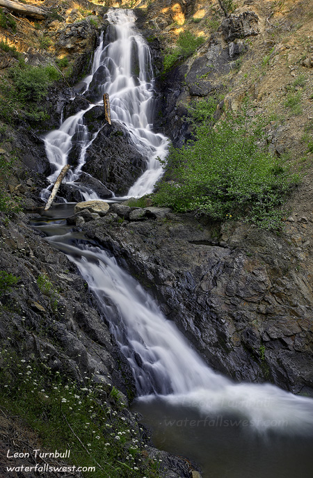
It was quite a warm day (80 degrees) for a hike up into the Desolation Wilderness, but up up up I went. When I got up above Eagle Lake, I left the crowds behind me, and I came into view of the waterfall for the first time. I could see that the cliff beside the waterfall was definitely far too steep to make a descent. It seemed so much tamer on GE. There was no way I would be descending down that. Nonetheless, I continued on, hoping to find another route down once I got there. I came to another dilemma once I reached the spot where I was to break off trail and head down to the falls. It was steep! It did not look too promising, and I was considering giving up my quest for the day. But … I had come all this way up here, so I decided to try it. As I descended, I actually found a path. People had obviously been down here before. It was a good path in spots, and in others, it was hard to follow. But I was following it. It was not my original planned route, but it was leading me down to the falls. As I descended, I could see the waterfall, and I could easily see that it was definitely a lot bigger than I had anticipated. It was certainly no 50 footer. This was very cool. I was feeling very good.

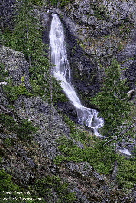
Then … as I crossed a brushy ravine and headed up onto a ridge, I could see the waterfall in plain view ahead of me. It looked like I was going to make it. Then all of a sudden … I came to a dead end. A big cliff dropoff right in front of me. Crikey! I had almost made it all the way to the falls, and now I was stopped. Well, I could still take my pictures from this spot. The view of the falls was excellent from here. But I was definitely bummed that I did not make it all the way to the waterfall. After taking my pictures, I did find a possible descent down the cliff. But I could not tell if I would be able to continue all the way or not. Maybe it was possible. But it was now getting very late. I had run out of time. If I went down now, I would be hiking back in the dark. So I decided to not try it this time, and come back another day.

I started heading back up to the main trail. It was a very steep and slow ascent. The high elevation was definitely getting to me, and I was even feeling a bit dizzy as I ascended. Finally, I got back to the main trail. Now it was all downhill back to the car. I was quite bagged though from this very strenuous hike, and I drank all the water in my camelbak before I made it back down, and I arrived just after sunset. Some light clouds had rolled in surprisingly over the Bay, and I was actually hoping for a nice sunset at Eagle Falls. But I arrived there a bit too late (but the clouds did not really color up too nicely anyway, so I didn’t miss very much). I was totally bagged from the hike. I stopped at McDonald’s to refuel myself with a couple chicken sandwiches and ice cream before making the long drive home.

2 Comments

Faucherie Lake Falls

    This is Faucherie Lake Falls below Faucherie Lake (18 ft. high). I arrived here at about sunset time after my hike to the waterfalls above Faucherie Lake. The mosquitoes were coming out just as I got here. Darn buggers. I put some dope over myself to keep them away from me while I took my photos. It worked.

      It is a pretty little waterfall for sure. The only way to get a view of it is from the other side of the creek, which could be difficult to cross if the flow is too high in the creek. Fortunately, I was able to wade across easily when I was here. I actually kept my hiking boots on as I waded back across the creek to my vehicle. I had forgotten my water shoes and I had already sliced my foot open on the sharp rocks crossing the first time. I figured I should just keep my boots on going back so as to not slice the other foot open. Good call.

        No Comments

        New Site

        Hi Folks.

        In case you are wondering where everything is on my blog, I have switched over to a new web host and I am still in the process of trying to move over all my blog posts. Hopefully that will not take too long!

        Update: I was able to import all my old posts but could not import the comments or categories. So if you have commented on a past post, sorry about that. But you can start adding new comments any time! 🙂

          No Comments

          Rattle and Hum

          Rattle and Hum … to put it lightly, that is the extent of what my brain was doing the entire drive up to Faucherie Lake the other evening. Not to mention my poor vehicle. The road up to Bowman Lake and Faucherie Lake has got to be the roughest, craziest, wickedest, bumpiest road in the greater Sacramento area bar none. It takes a full hour or more to drive the 12 miles on the dirt road. That is 12 miles per hour. And the last 7 miles or so from the west end of Bowman Lake up to Faucherie Lake is the worst. I was doing less than 5 miles per hour much of the time. The thing that totally boggled my mind, however, is that I saw two low clearance cars driving this road. You would have to be absolutely nuts of the highest order to drive this road in your car. I was going bonkers in my high clearance SUV.

          Anyway … needless to say, I don’t like driving up to Bowman Lake or Faucherie Lake very often. This was actually my second trip up there this year (which is one more than any sane person would do in a year). The first time I just drove to Bowman Lake. This time I drove all the way to Faucherie Lake. And as I said, the last part is much rougher.

          I was looking for new waterfalls of course. I have been to the waterfall below Faucherie Lake before. But there are some more falls above Faucherie Lake, along Canyon Creek coming down from French Lake. I checked dreamflows.com and it indicated the flow on Canyon Creek below French Lake was a paltry 6 cubic feet per second (cfs). That did not bode well for me. In fact, it seems that it is extremely rare that they let out more water from the dam at French Lake. Yet, I had heard that the waterfalls above Faucherie Lake were quite good ones in the summer. So I wanted to go check out this 6 cfs flow and see what these falls were really like.

          I arrived at the trailhead later than I anticipated (because the drive took a lot longer than anticipated). I had hoped to hike all the way up to French Lake, but I didn’t think I would have time now. Anyway, the first order of business is to cross the dam at Faucherie Lake. Stupidly, I forgot my water shoes at home. Thus, I had to wade across in my bare feet. As I was crossing, I noticed a lot of little fish in the stream below the dam. Then I noticed a snake in the water ahead of me! It was not a rattle snake. It was just swimming in the water, probably trying to catch the little fishies. Well I don’t like snakes, rattlers or not, and this one was in my direct path. So I went wide around it on the rocks. That is when I noticed a second snake, also not a rattler. Now I was pretty wary, cuz there certainly could be rattlers around here. When I got to the other side of the creek, I noticed that I had slashed my foot open on the sharp rocks. Serves me right for forgetting my water shoes. But I blame it all on the snakes. It was a pretty deep cut, but it was not bleeding too badly and it did not hurt. So I put my socks and hiking boots back on and continued on the hike (the foot did not start hurting me until after I got back home, and then I was in quite some pain).

          As I approached the inlet to Faucherie Lake on Canyon Creek, I could hear the creek rushing quite strongly. It sure seemed a lot more than 6 cfs. How could this be, I wondered? I did not know, but I was definitely pleased about it. There is a trail leading up the west side of Canyon Creek, and it was fairly easy to follow, though a bit faint in places. I reached the waterfalls in short order. I found a series of four separate drops all in a row. None of them are individually very high or spectacular (the highest is 20 ft.), but taken together, it is definitely a beautiful location and an excellent series of waterfalls. It was a bit cliffy (as per usual with my hikes), and difficult to get down to the creek side to get a closer look and photograph, but I carefully made my way down to one section where I could get a nicer view.

          I then continued up the trail to Weir Lake to its outlet. I suspect that a lot of the flow in Canyon Creek was coming from Weir Lake where there is no dam, but I did not go far enough to see what the flow into Weir Lake was like. I was out of time and could not continue up to French Lake, so back down the trail I went. I stopped at the waterfall below Faucherie Lake as well, and got there just as the sun was setting and the mosquitoes were coming out. But I didn’t see any of the little buggers until I got there, so I did have quite a pleasant evening.

          No Comments

          Horsetail

          Well I really hadn’t been out hiking in a long while and I was anxious to get out and see something. It’s been awfully hot, it is mosquito season, and the waterfalls are well past their peak by now.

          I knew 790 ft. high Horsetail Falls would be flowing well, however. And since it was 100+ degrees in Folsom, I figured it was time to escape the heat and head into the mountains for a breath of cooler air. I watched the temperature gage in my car decline from 100 as I drove up the hill. When I arrived at the trailhead, it was at 83. Well that is not too bad. Any higher and it would have been a bit too warm for hiking, so I was pleased, and it would get cooler as the evening went on.

          There were lots of people and cars parked at the trailhead on this Sunday evening. It is a very popular trail, but when I have been here before, the people are usually all exiting by sunset time. This was what I expected again. I would see a lot of people on the trail while I was hiking up to the falls, but once I got there I would be all alone. That was almost but not quite the way it worked out. I did see a lot of people exiting as I hiked up to the falls. When I arrived at the waterfall, there was no one else in the vicinity where I was photographing the falls, so I did have it to myself mostly. But there were still quite a lot of people descending from the top of the falls surprisingly, so I was not the only one in the area, and I was not the last one to leave the area either (when I went back down). The best thing though was that there were ZERO mosquitoes! I’ve never really encountered a lot of mosquitoes here before, but when I was here at the same time a couple years ago, there were a lot more. But zero is very good! I wonder if mosquito season is about over now. Perhaps it is time to head out more into the high country.

          Anyway, Horsetail Falls was flowing quite well, but not quite what I was expecting. Considering the large snow pack we had this year, I was expecting this waterfall to be amazing, but it was clearly past its peak. It had about the same flow as it did when I visited here in July two years ago (and that was a drought year). Nonetheless, it is still an awesome waterfall. I think though that I arrived a bit too late in the evening for best light. The waterfall was all in shadow and the nice warm light on the rocks was all gone. I probably should have been there an hour earlier in the day.

          As I was photographing the falls, I was approached by a family coming down from the top. The very friendly guy asked me if I could photograph them by the waterfall, and he would pay me. I said sure, and that he didn’t have to pay me. But he insisted on giving me $10. Well that was enough to pay for my parking and a hamburger later. Sweet. Anyway, I photographed them by the falls. We talked for awhile and then they went on back down while I took a couple more shots of the falls before I headed back down myself. It was a lovely evening.

          Please sign up for one of the new Waterfall Photography workshops I am offering this Fall. Sign up by July 31, and receive a free 20-30 print of your choice.

          No Comments