Epic of all Epic-ness

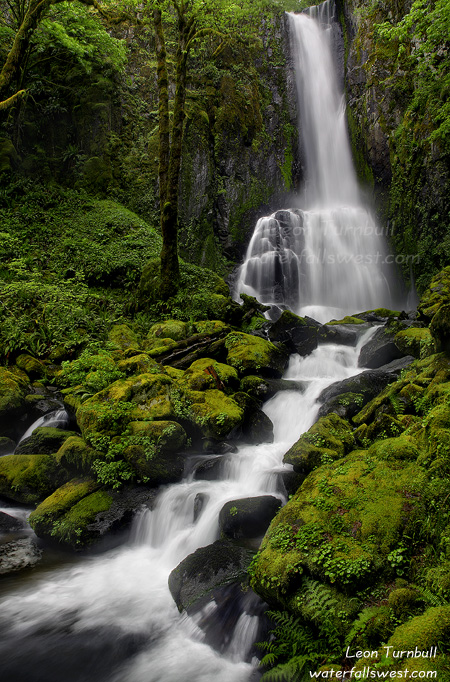
New York Canyon Falls …a 500 ft. high towering monster in the North Fork American River Canyon. Rugged beauty unparalleled. Remoteness to the highest degree. No trails. Sheer cliff drop-offs. Heavy thick brush. Where so very few have gone before.

I have been here once before with my brother-in-law a few years ago. We did it in a two day backpacking trip starting at Mumford Bar and hiking up the North Fork American River to New York Creek. From there we had to scramble up New York Canyon to get a view of the waterfall. There are no trails up New York Canyon and it was very difficult. But it was an awesome trip.

Now to return once again. But can the trip be made as a day hike? I learned about this possibility from the late Russell Towle, a true adventurer, explorer, and first class advocate for the North Fork American River Canyon, certainly one of the most beautiful canyons on Earth. I mapped out the probable route on my GPS, called my good friend Rob Macklin to come along on the journey, and set off from home at 3:15AM.

The idea for a day hike is to hike in from the top, off of the Sailor Canyon Trail. The road to Sailor Canyon is not open until much later, after most of the snow has already melted. By this time, the waterfall’s flow will be much less. This is why my brother-in-law and I went in from Mumford Bar. But you can’t do a day hike from Mumford Bar. From reading Russell’s notes, I anticipated three very major obstacles on this hike. But there were actually four: brush, cliff, creek crossing, and cliff.

We arrived at the Sailor Canyon trailhead well before sunrise and started hiking down the trail. At some point along the trail, we had to cut off and head cross country over to New York Canyon. There are no trails, signs, or markers. Only my GPS based off of Russell’s notes. At the specified point, we headed over through the brush. The going was pretty good. A huge forest fire whipped through this region a couple years ago, and fortunately for us, cleared out a lot of the brush. I can’t imagine what this hike was like before the fire, but I heard about a wall of practically impassable manzanita brush along this section, in particular as you cross a small ravine along the way. The brush, however, was hardly noticeable as we crossed the ravine. Obstacle #1 surpassed.

The next section was the one I was most concerned with. After the ravine, you need to find a way to scale a cliff wall. There is supposedly one and only one route from the ravine to top of the ridge. I had no idea where this route was or how to find it. But my mapping with my GPS was spot on. It led me right up the cliff wall, where we had a stupendous view of the canyon from the top. We even found the faint trail leading up the ridge. Obstacle #2 surpassed.

On the other side of the ridge, the “trail” leads back down to New York Creek, which we needed to cross above the waterfall. It is probable that much earlier in the spring, the creek would be raging far too high to cross. But now with the flow much reduced it was simple. We could easily rock hop across. Obstacle #3 surpassed.

On the other side of the creek, the “trail” leads up to the top of another ridge. More stupendous views. We were now close to the brink of the waterfall. We needed to work our way down the other side along the cliffs, and then down down down to a little knoll located to the side of the waterfall. The sun was coming up over the mountains, and beginning to light up that little knoll. Could we make it down there in time? This is where we came upon obstacle #4, which was the worst one of all. We could not find an easy route along the cliff edge and down to the knoll. Except … for one incredibly narrow rocky route with a huge drop-off. We had to crawl along this very carefully using the rocky handholds, and hoping they would not break as we held onto them. It totally freaked me out. I do not like scary heights, though Rob the Mountain Goat loved it. Obstacle #4 surpassed. (on the way back up, we were able to bypass this freaky ledge, thankfully).

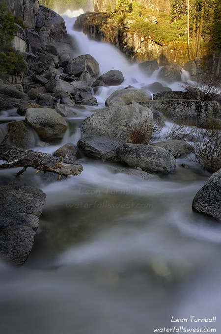
After the narrow ledge, we easily worked our way down to the knoll. And were rewarded with spectacular views of New York Canyon Falls. We raced the sun to take our photographs as it was rising up above the mountains now. We went further down, more into the shade, so we could take some decent shots. The waterfall was definitely on the low side of flow. If we had been here even 3 weeks earlier, it would have been roaring much more greatly. Still though, it is an unbelievably spectacular location and waterfall; I think it is the best waterfall in California outside of Yosemite. I measured it officially to be 462 ft. high.

After shooting New York Canyon, we went over to the West Fork where there is another waterfall. Then we had some food and rest before heading back up the canyon. On the way back up, we came to the ridge with the hidden route through it and decided to take a different path. Instead of going back across the ravine and brushy area, Rob wanted to go straight up the ridge, which would essentially lead us straight back to our vehicle. It is just that it was quite a steep climb up that ridge. I don’t know how I let him talk me into doing this. The ridge is not named, so I am officially naming it “Macklin Ridge”, since it was Rob’s idea to go up there. It actually turned out to be a very good plan. The views of the canyon from Macklin Ridge are incredible, and we found a couple other waterfalls as well. I will definitely need to return here and try to get up close to these other waterfalls. The fire had cleared out most of the brush on Macklin Ridge, so it was relatively easy going. Just a steep climb up to the top. Surprisingly, there was even a trail going up the ridge. Obviously, other people had been up there, and I wonder if much of the trail was made from the fire fighters.

After our epic hike, we needed an epic lunch. And the Ore Cart Steakhouse in Foresthill was definitely up to the task. This building was built in the 1850’s and is complete with underground tunnels and a 3 layer brick roof (to keep out the injuns). The food is pretty amazing as well. Rob had been here before and knew they made this monster burger which is enough for two people. I was pretty hungry though and had my doubts. Will this really feed two hungry men? The menu just said “biggest burger in Placer county”, but didn’t say anything about it being for two people. Anyway, we ordered it. The service in the restaurant was slow as molasses but we were in no hurry. When the burger finally arrived, I couldn’t believe how huge it was. It was certainly the biggest burger I have ever laid my eyes on, and it was easily enough for two people. I was starving and wolfed down my half of the burger and fries very quickly, but was full and satisfied afterwards. Rob finished his burger, but just barely. I told him he must not have worked hard enough on the hike that morning if he had troubles finishing that burger.

It was definitely a glorious day in the North Fork American River Canyon.

5 Comments

Wrong Way Bonehead!

Does this look like Lemolo Falls to you? If you have been to Lemolo Falls and know what it looks like, I am sure you are thinking something is not right with this photo!

The last two waterfalls I wanted to visit in the Diamond Lake area were Warm Springs Falls and Lemolo Falls. On the drive out to Warm Springs, we found that the road was closed due to construction. That was a bit of a bummer, and I’m not sure if there was another way to get around to that waterfall, but I turned around and decided to just head on over to Lemolo Falls. Now … I do know the proper way to hike to Lemolo Falls. However, I saw a sign along the road that said “Lemolo Falls, 1.5 miles”. This was a secondary trail that I had not heard about before, and since it was about the same distance as the “proper” hike, and since it was right here and meant I did not have to drive all the way around to the other trailhead, I decided to try this hike. Big mistake. I figured, however, that this trail either joined up with the other trail, or it would give me a good view of the falls from the other side of the canyon, perhaps even a better view.

Well … the hike itself was very lovely and probably much better than the other hike, as it followed the river the whole way down to the falls. There were plenty of small cascades along the river in the 5 to 10 ft. high range. It was certainly a beautiful hike. Eventually, the trail approached the top of the falls and I realized that I would not be getting a very good view point of the waterfall. The trail continued on down the river but did not go to the bottom of the falls, and the viewpoints on this side of the creek were mostly unmentionable. I scrambled down to this (dangerous) spot right near the top of the falls. This was the best view I could find. It was definitely a bit on the freaky side with steep dropoffs and questionable footing. I tied up my dog because she was making me nervous walking around close to the cliff edge, and I sure didn’t want her to fall. It is really a pretty nice and quite different view of this waterfall, so I’m not complaining too much. I still think, though, I would have been better off going the proper route.

2 Comments

Whitehorse Falls

Getting back to Oregon now … After visiting the tallest waterfall in the Diamond Lake area (Watson Falls), we immediately went to the smallest (Whitehorse Falls). This little guy is only about 15 ft. tall. For some reason, I couldn’t get an accurate reading on my laser rangefinder, so I’m only guessing at the height. ha ha. But it’s definitely not higher than 15 feet. Still though, it’s a pretty little thing.

No Comments

The Crazy Things I Do

One evening last week, I went on a wild adventure to Wentworth Springs up on Ice House Rd. This was the 3rd time this year I have tried to get to a waterfall up there. Would the 3rd time be a charm?

The first time, I got stopped by too much snow on the road. The second time, there was still too much snow on the road, but I tried snowshoeing in from Loon Lake instead. I did not get very far that way. The only option was to wait until the snow had melted on the road. Would it be melted now?

Wentworth Springs is about 9 miles from the turnoff to Loon Lake, so I started counting down the miles the closer I got. 9, 8, 7, 6, 5, 4 … now there was snow on the road. I was thinking “uh oh”, but it wasn’t too much to stop me yet. 3, 2 … and then I came to a dead end.

There was a sign on the road for the Rubicon Trail, followed by a huge puddle and a fast rushing creek flowing over the road. I did not realize that the road to Wentworth Springs was actually part of the Rubicon Trail. Easily passable if you have a high clearance jeep, but not so much with a low clearance SUV. There was no way to continue further in my vehicle. But not too hard to continue on foot … or bike … and I was only two miles from the waterfall. I just happened to have my bike with me, for this very reason. And it would be a lot faster on bike than foot, so I thought.

So I put on my water shoes, packed my camera gear into my bike pannier bag, strapped my tripod onto the bike rack with bungy cords, and set off on the wild adventure. The first item of business was crossing the creek, so I just had to lift my bike above the rushing waters and wade across. It was not too difficult. Soon after, I came to a second fast rushing creek. Would this be a frequent theme? I crossed again, and continued biking. There were no more rushing creeks to cross after this, but there were a heckuva lot of huge puddles, very deep, and stretching right across the entire road. I had to frequently get off my bike, walk through the huge puddles carrying my bike over them as best I could, then get back on the bike on the other side. It was slow going.

Finally I came to a crossing of Jerrett Creek (where fortunately, there was a bridge). According to my GPS, this was where the waterfall that I was looking for should be. There was a small waterfall on Jerrett Creek just up from the bridge which looked like a pretty nice cascade, but this was not what I was looking for. I was looking for a waterfall on Gerle Creek, but I did not see Gerle Creek anywhere. According to my GPS, Jerrett Creek dumped into Gerle Creek downstream from here, and that is where the waterfall should be. So I ditched the bike, and started scrambling down the creek. But it was very difficult. Firstly, there was a heckuva lot of brush. Secondly, Jerrett Creek was going every which way but loose. The entire area was flooded and it was very swampy, so I essentially had to splash my way through the swampy area and try to follow the main branch of the creek downstream. The creek was ice cold, and my feet were starting to get numb. I knew that I could not continue like this for very much longer and considered turning back. Finally I reached Gerle Creek, but there was no waterfall there as my GPS was telling me there should be. So I had to turn back. When I got back close to the road, that is when I saw the waterfall. There it was, on Gerle Creek, and right beside the road! If I had just continued biking up the road a short distance after passing Jerrett Creek, I would have seen it! Well, talk about wasted effort (but good exercise at least, I guess). Anyway, I retrieved my bike and walked up to the waterfall.

By now it was getting quite late, very close to sunset (and I still had to bike all the way back to my vehicle). I scrambled down to the creek as quick as possible and took my pictures. Then I went back to the waterfall I saw on Jerrett Creek and scrambled up there to shoot that waterfall as well. When I was all done, the sun had already set. I did not even take the time to measure the height of the waterfalls. I had a 30 minute bike ride back to the car, and I knew it would be dark by the time I got back. So off I went back down the road as fast my legs could peddle. It was actually much faster going back. I biked right through some of those puddles instead of walking through them (for the big ones though, I still had to walk). Along the way, I met up with some folks parked on the side of the road with their jeeps. They were trying to drive the Rubicon Trail. They probably thought it very strange to see a bike rider coming along in the near darkness. I talked to them for a couple minutes, but I had to get going quickly. I got back to my car just as it was getting quite dark. An excellent evening, and I was very glad to have found these two waterfalls. But I think there is a lot more in this area, and I will have to get back there to do more exploring some day.

No Comments

Oregon. Day 4

I was very ecstatic when I learned that the trail to Toketee Falls was open. This trail has been closed since the spring of 2008 when a huge storm pounded this area and caused heavy damage to the trail and viewing platform at Toketee Falls. I had heard that the trail was not supposed to open until next year, but I also knew of people who had gone in there earlier this year (at risk of a $5000 fine), and they had indicated that the trail had been completely re-built. I wondered about this. Toketee Falls was one of the main waterfalls that I wanted to see on my trip to Oregon. I’ve been wanting to see this one for years now. Would I risk a huge fine by going in there even though it was still closed? I don’t know if I would or not. With my luck, I would get caught and a $5000 fine is something I sure could not afford. Nonetheless, we stopped at the trailhead on our way past and lo and behold, the trail was open! Hoo yah! I was so excited and happy to see this! This trail now being open made the whole trip to Oregon worthwhile for me. It must have opened on Memorial Day. I was ecstatic. We would be one of the very first people in to see Toketee Falls (legally) in 3 years and this is probably one of the very first photos taken of this falls (legally) in 3 years.

Toketee Falls was flowing very heavily as well, due to all the recent rain. The river was just pounding down this gorge, an amazing sight. Toketee Falls certainly lives up to its name (“graceful”), but it was also very powerful with all the water flow.

No Comments