For my second trip of the week I would take Journey with me. This hike was a little higher elevation so I hoped rattlesnakes would not be an issue. Yes I know rattlesnakes exist at higher elevations but they are much more common at lower elevation. I figured above 4500 feet the risk is OK. This hike starts at 4000 and goes up to 6000. Crossing fingers.
The Trinity Alps seems to have more deer than anywhere else in California. On the drive to the trailhead I saw over 10 deer along the road. I wondered what would happen if the deer came into our camp when Journey was there? Will the deer just not even come close to us? Or would Journey chase them off into the woods? I hoped it would be the former.
We started hiking at about 8AM. It is a 5 mile hike with 2000 feet elevation gain. It started out overcast so I thought maybe we could get to the first waterfall with good lighting. However, just before we got there I realized I lost my GoPro. What the heck? How far back was it? I had no idea. We dropped our packs and went back down the trail. Thank the Lord I found it. We got back to our dropped packs and now it was sunny. Ah well. We took a good break and Journey rested. We made it to Granite Lake at about noon and had our lunch. There was another group here and they had taken the best campsite, the only one that has a good view of the lake. It is very brushy around the lake so it is not possible to get down to the lake shore (at least not easily). Well that was a bummer but I found a nice large open area opposite them. At least I was able to take photos of the big waterfall dropping into the lake. Journey barked at the other campers a bit even though we were over 200 feet away from them. I think that when they went to get their water they had to come closer towards us and Journey did not like that. Ha ha. It is quite strange for her to bark when mom is not around. Usually she is absolutely perfect with me.
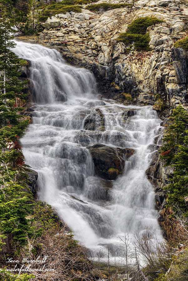
In the afternoon, the clouds rolled in. The weather forecast said there was a 30% chance of thunderstorms. I figured we should go see the waterfalls before that happened. There are multiple waterfalls here. There’s a big huge one dropping into the lake as I mentioned. The upper falls is a gorgeous 60 ft. drop (pictured here). The middle falls is about 25 ft. and the lower falls about 20 ft. A couple others were just too difficult to get to. Too brushy. Much too difficult, especially for Journey. She does not like the brush and this brush was very bad. We were eating the brush it was so bad. Even this upper falls had some that we had to crash through. At least we got to some of the waterfalls though.
I heated up a nice dehydrated dinner for her (thanks to my wife for making it) and we went to bed early. She was pooped out and went right to sleep when we got in the tent. Day one is over. Day two is about to begin.
After I got in my tent at Emerald Lake, more deer came into my camp. One of them slept all night right outside my tent. I could hear it making noises in the night.
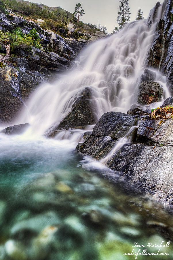
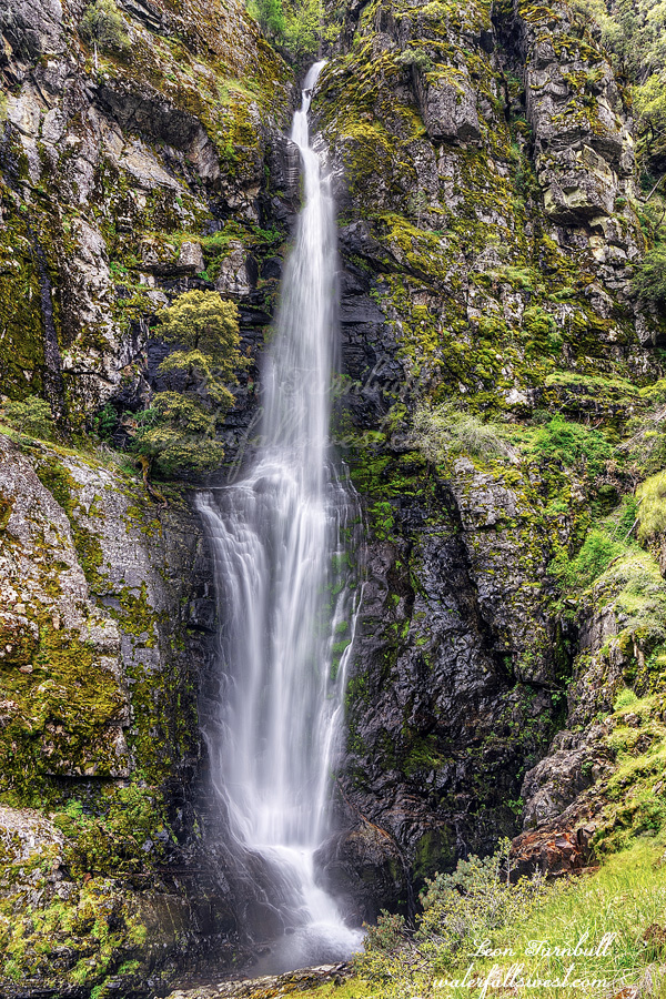
In the morning I went down to Stuart Fork Falls first thing. There is no good view of this waterfall. I suppose this is the reason I have never seen a good picture of it before. You can only see the lower tier, the main upper section is mostly hidden. I had hoped to find a better viewpoint. Bummer. However … I pondered the situation. Hmmmm …. Could I climb up the lower tier to reach the main drop? It looked possible. Was it stupid? No. It was a bit sketchy but I made it up and over to the bottom of the waterfall.
Stuart Fork Falls is much better than I expected it to be. It is a beautiful 30 ft. drop (not including the lower 16 ft. section). No one has ever done this before? It is completely worthwhile to get up close to it. Three awesome waterfalls on this trip. I was so happy.
I returned to camp to find more deer. However, they all ran away when I approached. This is what deer are supposed to do! Much unlike those thieves at Morris Meadow.
It is a long 13 mile hike from Emerald Lake back to my car but mostly downhill, thankfully. I started at 8AM and finished at 2:30PM. It was a stupendous backpacking trip into the Trinity Alps Wilderness. Trip number one is over. Trip number two is about to begin.
The deer returned in the morning. Not just a couple this time, there were more than seven now. The same one from the previous evening was there and was the first into my camp. She liked to lick my pee. Others came into my camp as well, but some stayed in the meadow. A more aggressive one kicked out my most friendly girl from licking my pee. When another deer came up to get a lick, it kicked her in the face. What a mean deer! They were now all over my camp while I was trying to get ready to leave. They tried to get in my food but of course I did not allow that. One of them was licking my camera which I had set up on my tripod. I did not want them to “accidentally” knock it down so I laid down the camera and tripod on top of my tripod case (note: the heavy camera on top of the case) I went to get my water which was about 20 feet away. This was the opportunity they had been waiting for. I heard a big noise, looked up and saw my camera and tripod now a couple feet away flipped over, and a deer taking off like lightning into the forest. It took me a few seconds to understand what happened. My tripod case was gone! The thief stole my tripod case! I am pretty sure it was the mean one, I cannot prove it, but I would bet on it. I went into the woods to look for it, hoping that the deer dropped it. I could not find it. When I returned to camp, another deer was trying to make off with my camera case! I yelled at it, and thankfully it dropped the camera case. These are not innocent little deer here. They are a band of thieves! I am sure the mean deer has a stash of campers’ items hidden away somewhere in the forest. Look what I got today, honey? Stupid humans. I don’t think I will ever trust a deer again. For the rest of this trip I made sure I had everything stashed away in my tent whenever I left camp. Of all the things they could have taken, the tripod case was a minor item. However, I had to be careful because my tripod legs unscrew easily and I have lost one or two of them before which is why I always keep the tripod in the case. If they had gotten off with the camera case that would’ve been bad because I had some important items in it including my expensive filter. Or what if they took one of my hiking shoes? How awful would that be!
I left camp early because I had enough of the deer. They were still in camp when I left. It is a 4 mile hike to Emerald Lake. I arrived about noon, set up camp and made my lunch. I relaxed in the afternoon, trying to find what little shade there was.
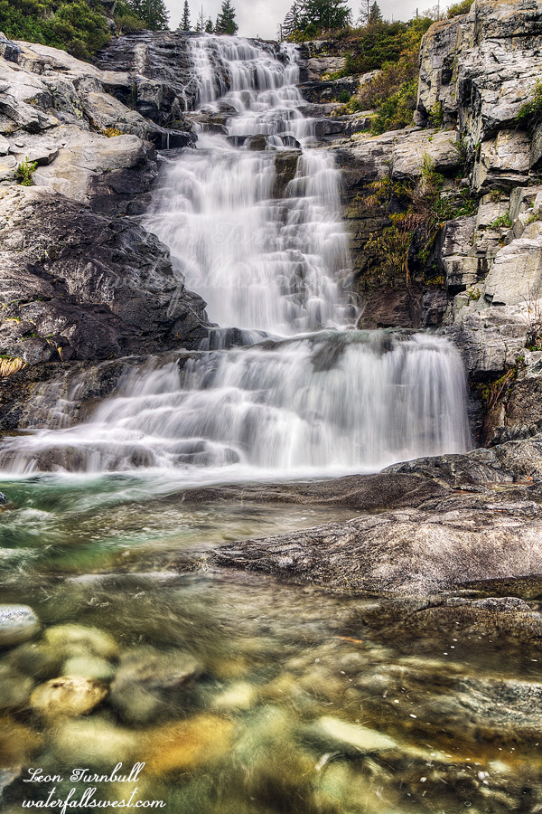
At 3PM I started my afternoon hike. I wanted to hike to Sapphire Lake and beyond. I thought there would be some waterfalls at Sapphire Lake but it turned out there was nothing significant. There was a big one, however, at the end of Sapphire Lake but snow lingers well into late spring. The last satellite image I saw was before the last snow storm and there was still a lot of snow. The route would be impossible if there was snow. There are too many dangerous drop-offs along the lake. However, the route was free of snow! I was surprised. I was not expecting to make it at all. The trail is not official or on any maps but it is a good one (overgrown though). At the end of the lake I got off the trail and headed over to the waterfalls. It became extremely brushy as I approached the waterfall but I made it. I was ecstatic!
The lower section of Mirror Lake Falls is 51 ft. high (shown here). It is absolutely gorgeous. There is a middle and upper tier as well but it seemed too brushy and I was out of time as well. At least I got a decent photo of the middle tier. This waterfall made my entire trip. I returned to camp at sunset, completely exhausted. Day two is over. Day three is about to begin.
The Stuart Fork Trinity River. This hike was on my list but not at the top of my list. Nonetheless, I think I smashed it. Three awesome waterfalls. I took my vacation earlier than usual, in April this year because of the lack of snow. I was planning to go to Yosemite but the April storms changed all that. Lingering snow showers in Yosemite were in the forecast. For the north, however, the weather looked a lot better. And it worked out well because my wife and Journey would be up north as well.
I did not take Journey for this first trip (I had a second one planned for which I did take her). The reason is because this is a low elevation hike and I had read there are many rattlesnakes in this area. I am freaked out about taking Journey to places where there is a high possibility of rattlesnakes. I did not see any, however. Only one little garter snake. It would’ve been a hard hike for her anyway.
I arrived at the Stuart Fork trailhead and started my hike. I would be hiking 8 miles to Morris Meadow on the first day. I only saw one other couple the entire trip. They were on their way back down from Morris Meadow. The lady did give me one good tip about the bridge at Deer Creek which is a little bit hard to see, and I noticed that they also picked up some trash (which I was planning to get on the way back). So kudos to them whoever they are.
I found a beautiful spot by the river for camp. I made my dinner and hung out for a while. In the evening I started getting ready to go to the waterfall. A couple deer came into my camp. They were very friendly and not afraid of me whatsoever. One of them came right up to within 2 feet of me. Not joking. These were not just some random friendly deer. They were a scouting party. Send in your two nicest and friendliest members to scout the location before the invasion. But more on that later. I left them to wander around my camp and started for the waterfall.
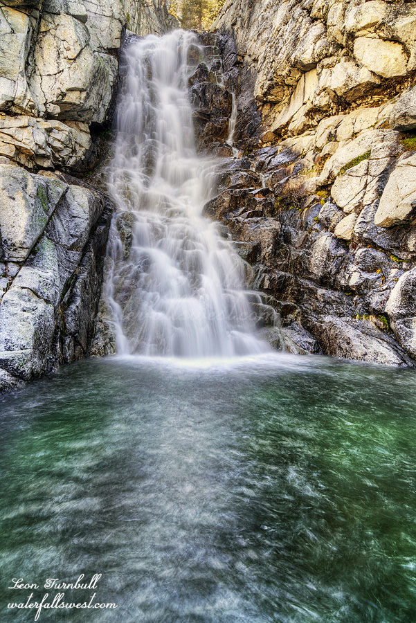
Initially, I had absolutely no intention about getting to this waterfall. Up close that is. I was just going to find a place to photograph it from a long distance away because I was certain that the Stuart Fork would be uncrossable. In most places it was but there was one spot near my camp that was easily crossable. What the heck, I may as well try this one after all. At first, the going was very easy. I was optimistic. However, the closer I got to the creek the more brushy it became. It was now a full on bushwhack. I was worried about snakes. This is the exact type of terrain they love to be in. I thought I should turn back but now I could see the waterfall up ahead through the trees. It was still a long way away. But I had to keep going. Finally, I made it to the bottom of the waterfall. Absolutely spectacular!
Bear Gulch Falls is 139 feet high. A stunning cascade. I spent some time here at the bottom of the falls, enjoying the view and taking photographs. It is a perfect viewpoint, nice and open and beautiful. I was so happy. There are upper waterfalls but they are far up the mountain and it is impossible to reach them. I went back down, hoping not to step on any snakes. The deer were gone when I got back to camp (for now). I went to bed. Day one is over. Day two is about to begin.
I did not really want to hike this weekend. I had too much stuff to do around the house and to get ready for my big hikes coming up next week. However, my wife was out of town for the day and I had Journey all to myself. She needed to get some exercise no matter what. I decided to head up to Ice House for a quick and easy hike. Jaybird Canyon Falls should be flowing very well.
The weather people said it was supposed to be cloudy by around noon with rain coming in later in the afternoon. That did not happen.
We arrived at the waterfall at about noon. There were clouds but they were very light clouds so the sun was shining through and it was quite bright. We ate our lunch at the falls and waited around for quite a while. Journey was very patient and laid down in the grass while I waited for the clouds. I managed to get one decent photo of the waterfall I think. On the drive home the heavier clouds did seem to roll in so I think it would have been much better if I had gone a couple hours later than I did. C’est la vie, right?
It is not a difficult hike but Journey seemed to be lagging and quite tired on the climb back up to the car. Was it too hot for her? I don’t think so. Was she still tired from playing too much fetch with mom the day before? Probably. Anyway, we had fun. It was a lovely afternoon in Eldorado National Forest.