Okay so I had heard there was a waterfall on Iowa Canyon Creek near Slab Creek Reservoir on the South Fork American River. Truth is, I did not remember much about it. Where was it exactly? What was it like? I don’t know. I had never been down to Slab Creek Reservoir before, so it seemed like as good a time as any to try it.
My son’s birthday party was at 1PM, so I only had the morning to go out and to make sure I was back in time. I considered going up to Tahoe for sunrise, but the weather forecast turned me off. It was supposed to be mostly sunny. If I had gone, there probably wouldn’t have been any clouds at all for sunrise (but considering that I didn’t go, it was probably perfect!). Anyway, so I decided to go to Placerville instead. It would be easier and quicker.
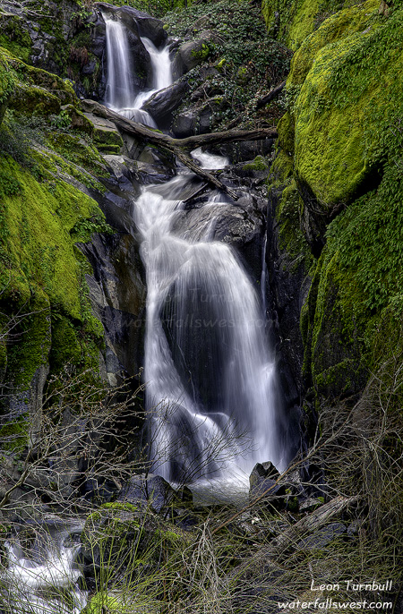
From studying my topo maps, I had mapped out the spot where I thought the waterfall on Iowa Canyon Creek would be, which was I thought a ways up the road from the dam. I arrived there around sunrise, and parked in a turnout, then got out of my car to take a look. I wasn’t expecting much, and I didn’t get much. What I found along the road was a pretty-ish little triple falls. It would be worth photographing perhaps, but it was clearly impossible to get down to it. The canyon walls there were a sheer steep drop down to the creek. Down the creek a bit, the terrain looked a bit better, and I thought maybe I could get down there, then scramble back up the creek to the triple falls. Not likely, but perhaps worth a try. I decided to first go on down to the dam and see what I could see down there, then come back to this spot later.
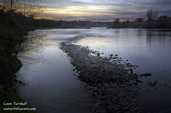
Once down at the dam, I could see a different waterfall off in the distance, dropping down into the river (not on Iowa Canyon). It was a nice one (on an unnamed creek), and it looked like it would be worth trying to get to. I made my way down to the river, and determined that the best way to access this waterfall would be on the other side of the river. I crossed the river on a footbridge, and started making my way down river. A lot of rock scrambling was involved in this process, but the going was good at first. Then I came to a dead end with a sheer cliff dropping right into the river’s edge. No way to go forward except to swim. I actually did find a spot where I might be able to rock hop across the river and then continue on the other side. But … I was in a danger zone, downriver from the dam. If I had crossed the river and they made a release from the dam, I would be trapped on the other side with no exit route. You may think that the risk was very minimal, but it was exactly one week prior I was hiking back from Dutch Creek in Coloma, and I saw that the flow in the river was double from when I started hiking that morning. If they released water from the dam last week, it was certainly possible they might release again this week. A double amount of flow in the river would make it uncrossable. So what could I do? Well, I decided to try to climb up above the steep cliff. I started making my way up through yucky prickly brush, and poison oak (but I didn’t get the “itch” this time). I found an old trail, which may have been human or bear, and followed it up. I went up, way up above the river, and I wasn’t making any progress getting around this cliff. I eventually gave up, and made my way back down to the river. Strike out.
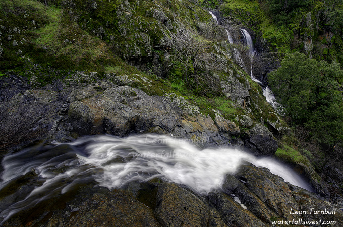
Back at the dam, I decided to make my way down to Iowa Canyon Creek to take a look see. I am glad I did! There was the waterfall I was looking for! Right near where the creek enters the river. It was a pretty one, 50 ft. high. But … getting up to it was a bugger! There is a ton of prickly brush along the creek here. I made my way through it with great difficulty, crossed the creek, and made my way up through more of the brush to the waterfall. But once there, I could not get in a decent position to see the falls. There was just far too much of that prickly brush to get up close to the falls. I found that the best view was from up on the cliff above, quite a distance from the falls, and that is where I took this photo from. I think I will need to return here with my water shoes and just splash my way straight up the middle of the creek. Maybe I can get up closer to the falls that way, but I just don’t know.