Beauty Found in Novato

This weekend I decided to head on over to Marin County to find some new waterfalls. With all the recent rain we’ve had, I figured this was the best time to seek out waterfalls in the Bay area. The vast majority of waterfalls in that area only flow well right after heavy rains. We did have heavy rains. But the thing is, the last rain was about a week ago. Would I be too late? The answer is yes and no.

My goal for this day: Novato.

I had heard about some new waterfalls in this area, and I figured this was a good time to check them out. Sometimes I like going to waterfalls that I have visited in the past. Sometimes I like going to new waterfalls that I have not visited before. This weekend I wanted to see some new ones.

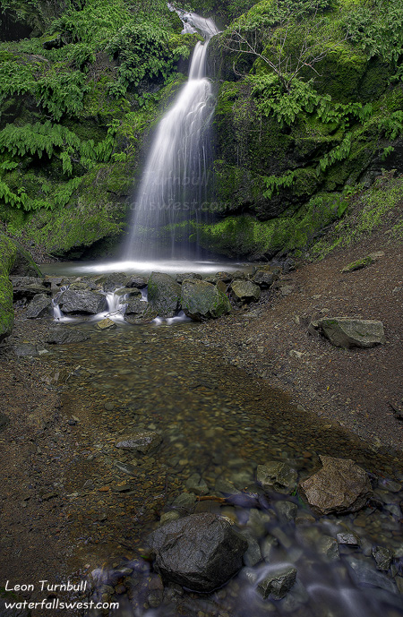
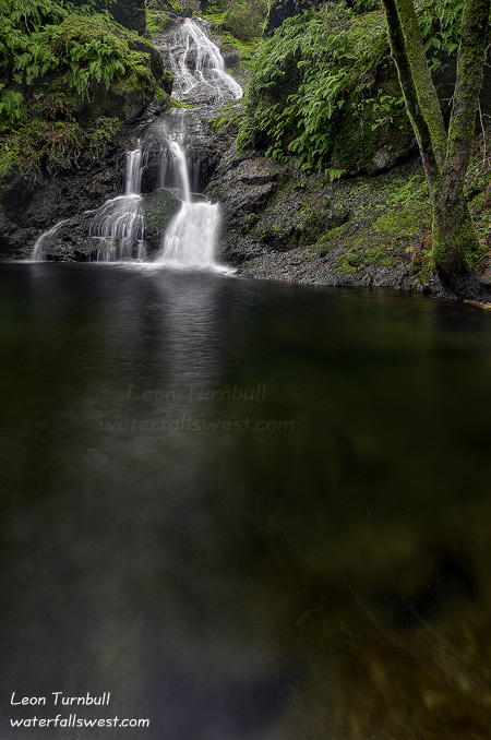
The name of the first set of waterfalls I found was Arroyo San Jose Falls. I cannot pronounce it (just ask my wife), but I can tell you that this creek holds some gorgeous waterfalls. There are actually four separate waterfalls on this creek, all in the range of about 25 to 60 feet high. The one pictured here is the first waterfall you come to (37 ft. high), a very short easy hike up the creek from the trailhead.

In order to get to the upper ones, however, requires a bit of work. The trail continues up above this first waterfall. It is steep, it is slippery, it is narrow in places, and it has dangerous drop-offs. After last week at Canyon Creek, I was not really in the mind of doing any difficult or dangerous scrambling. But I have come to realize that virtually all waterfalls can be quite dangerous. Even if it is an easy and safe hike to the waterfall (like this first one here), if you do any scrambling around the waterfall (like trying to get to the top of it, for instance), then all of a sudden you are in a danger zone and need to be extremely careful. So … I was very careful of course, as I scrambled up to waterfalls two, three, and four. Number two was the smallest one, and it was fairly easy to get to. Number three was the most difficult, requiring a steep, dangerous, descent down to the creek. I almost didn’t go down to it, but finally found some branches to hang onto, to guide my descent. Number four was the biggest one, 55+ ft. high. All of them were quite pretty, though not all easy to photograph. And the creek was flowing fairly well too, a week after the rains, but it was not “rushing”, and I was hoping that it would be flowing a little better than it was. That is the trouble with most of these Bay area waterfalls. You really need to get to them the next day after a storm. Still though, this one was sure pretty nice.

11 Comments
Deschutes Sunrise

It is a long two day drive from Rossland to Folsom. On the way back, we always stop overnight at Bend Oregon, about half way. Usually, I like to get up in the morning for sunrise photography in the Bend area, if I can.

This time … I got my family up as well. My idea was to drive up to Sparks Lake for sunrise. I did not realize, however, that the road to Sparks Lake is closed in the winter. This idea was just a last minute whim, and I did not do any research prior, so that is my excuse. I did know and have seen many beautiful photos from this lake, so I knew it was a place I wanted to shoot and I thought this would be a great time to do it. I got the family up very early, and we headed out, all the way up to Mt. Bachelor ski area. Then the road disappeared! What happened to it? I finally realized that the road that continued on to the lake was closed. Dang! So much for that great idea.

It was a bummer too because it was looking like a pretty wicked sunrise was coming on. Off in the distance to the east, I could see some amazing color starting to happen. But no place to shoot from. We turned around and instead of going back to Bend, we took the turnoff down to Sun River, which would be a short cut for us on our way back to California.

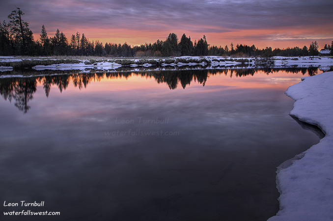
All the way down that road I looked for an opening through the trees where I could shoot sunrise. Nothing. Finally, at the bottom we came to a crossing of the Deschutes River, and I said “this is the spot”, slamming on the brakes and stopping the car on the side of the road, and then scrambling down to the edge of the river, just in time to get the last of the really nice sunrise color. Not too bad at all.

6 Comments

Lower American Canyon Creek

This shot is from a couple weeks ago, before the big rains we had here. It probably looks a lot different these days.

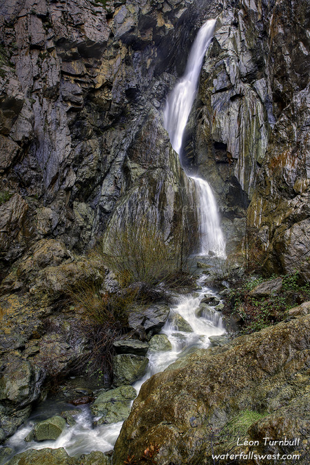
Lower American Canyon Creek Falls … that’s quite a mouthful. This is a relatively unknown and obscure 37 ft. high falls on American Canyon Creek, and it’s another pretty one.

The first time I was at this falls, last year, I did not get a photo of the falls that I was happy with, so I was definitely wanting to get back here.

I had a tough time finding the trail down to the falls this time around. I knew about where it was, but it seemed that the trail was easier to find last time. It also seemed steeper this time.

I was also hoping to get a better vantage point of the falls this time because I knew the water flow would be much less. No dice there. There is one and only one spot to photograph this waterfall. Even with less water, that pool at the bottom of the falls is very deep. And I didn’t feel like swimming on this day.

No Comments

The Big Waterfall

As promised here is my photo of the Big Waterfall on Canyon Creek. At 134 ft. high, it is the biggest of the many waterfalls on Canyon Creek. It was not at crazy flow, but it was flowing pretty darn nice. Canyon Creek is definitely one of my favorite hikes in this area. Lots of waterfalls, lots of beauty.

This was taken just after my mud bath, and if you haven’t heard about that yet, you’ll want to read my last post. Thus, I am not at all too happy with how this photo turned out, as I was struggling to get the shot taken with my camera soaked in mud, and my entire body muddy and dirty, and not too mention that it was still raining, and I could not (or would not) risk another fall trying to get a better viewpoint. At least my camera still works fine. Whew.

2 Comments

Executive Decision

So with all the rain we had here in northern CA this past week, you know the waterfalls would be roaring this weekend. Or so I thought. I was watching the flow of the North Fork Dam at Lake Clementine closely all week long, as that is a very good indicator on how the waterfalls in the area are flowing. But it never got much above 1500 cubic feet per second (cfs) all week, which is a heckuva lot lower than I was expecting with all the rain. So what did that mean? I figured it out by the end of the week, namely that most of the precipitation we had was coming down as snow in the mountains, so it was not contributing to the flow in the rivers. All the waterfalls at the lower elevations would be flowing great, and that is where I needed to go.

But where? I did not have much time this weekend to go very far, so it had to be close. I decided on my old favorite Canyon Creek Falls at Gold Run, which should be flowing very well as it is at a lower elevation in the foothills. Or so I thought.

With the weather breaking on Saturday, I decided to try a different spot on Canyon Creek, one that I had not been to before. This new spot would also possibly give me a great sunrise view overlooking the North Fork Canyon, if I was fortunate enough. Or so I thought.

On Saturday morning, I woke up bright and early, and it was raining in Folsom. What? I checked my cool new little weather app for my phone, and saw that it was raining up in the Gold Run area too. Actually, it looked like Gold Run was on the edge of the snow line. Hmmm. But the app also told me that there would be a break in the rain around 8AM. Or so I thought. Off I went, giving up on the sunrise option because of the rain, and just decided to find that new waterfall viewpoint, planning to arrive there right around the upcoming break in the weather.
I arrived in Gold Run … and it was snowing! There was about 4-6 inches of snow on the ground. Gold Run rarely gets any snow, so this was a bit unexpected. And with the snow on the ground, I was worried about being able to find this new trail at all, not to mention that parking would be a big issue.

So I made the Executive Decision.

I decided to change plans and take the regular route down to Canyon Creek Falls. With the snow falling, I thought it would be really beautiful down by the falls. This would be a rare opportunity to see these waterfalls with snow. Or so I thought.

It just so happened that when I was here last year with my friend, Rob, there was snow at the trailhead as well. Rob and I got very wet hiking through that snow, but since you lose a lot of elevation on the hike, there was none by the time we got down to the falls. I got very wet again today. There was snow all the way down to the first waterfall on Canyon Creek. Crossing the bridge over Canyon Creek was a bit crazy. It is a very narrow little thing (two 2×4 boards), over a raging creek, and there was 4 inches of snow on it. I slowly trudged across the bridge, clearing the snow on the way, in order to prevent slippage. On the other side, you have to crawl up a rock face, that was in full slick mode on this wet day. I made it safely, and continued on the the first waterfall on Canyon Creek.

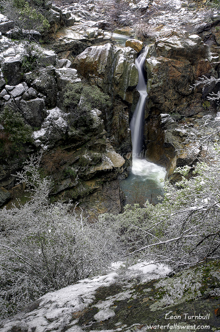
It was snowing hard, and as you can see in this photo, it was incredibly beautiful with the snow on the trees and rocks around the waterfall. The flow in Canyon Creek was pretty good, about the same as when I was here last year. But it was not crazy flow, as I was hoping. This again is due to the snow at the lower elevations the past couple days. I still need to come back here when it is going overboard. I did not go to the bottom of the falls this time, as I did with Rob last year. That would have been crazy today, with the snow and steep slippery slope.

I did, however, continue on down to the Big Waterfall. I will post that shot later. By the time I got down to the Big Waterfall, the snow had turned to rain, and there wasn’t much snow down there, unfortunately. It is definitely rather difficult to get down to the Big Waterfall in the rain when the ground is so slick. There is one particular spot right before you get to the waterfall that has a steep and deadly drop-off. I took one look at it and said no way would I try that. I wondered if I would have to turn around after getting so close, but I was able to get around that spot by a different and much safer route and made it to over to the waterfall. I did, however, take a tumble in the mud, getting myself completely drenched in mud, including my tripod and my camera! The camera still worked, fortunately, and I was able to take a couple shots of the falls. I’m still hoping that my lens is not ruined. I then made the long, slow trek back up the trail. The snow was melting now, and was mostly all gone back when I got back to the first waterfall. By the time I got back to the car I was wet, cold, tired, and very muddy.

5 Comments