When I was here a couple weeks ago there was a new waterfall I found that I could see from Sailor Flat Road. I’ve seen it in the past but never had a chance to go there. I was hoping to get to it on the morning after I camped at NYC Falls but by the time I got there it was already in the sun. It looked like a big waterfall and it was flowing well. It was time for a return trip. It should only take a minute.
I was definitely not going to hike all the way from Ford Point again. Thanks to a friend of mine that is in the know, I knew that Foresthill Road had been closed because the county was still plowing. I also knew from him that they had finally finished plowing the road to Robinsons Flat and so now the road was open for the summer. I would be able to drive all the way to Sailor Flat without any issues.
I headed out one evening after work. It was the middle of the week and I saw no one on the road at all. Except … I passed one vehicle that was “parked” just off the road near Tadpole. It was 5PM. There was a lady and a couple kids. It looked to me that they were up there playing in the snow. Hmmm … I continued driving to Sailor Flat. It had only been about 1.5 weeks since I had been up there. Most of the snow on Canada Hill was now gone! In just 1.5 weeks! That is some crazy snow melt.
I got to Sailor Flat, parked, and donned my snow shoes. Snow shoes were needed. There was still plenty of snow. I would not be hiking all the way down Sailor Flat Road. That route would be too difficult to get to this waterfall. I had a different idea. In short order I came across my second bear of the year. This was a small brown colored one and it ran away when it saw me. Just like it is supposed to do. (unlike the earlier one I saw this year). I think I did get some video as it was running away.
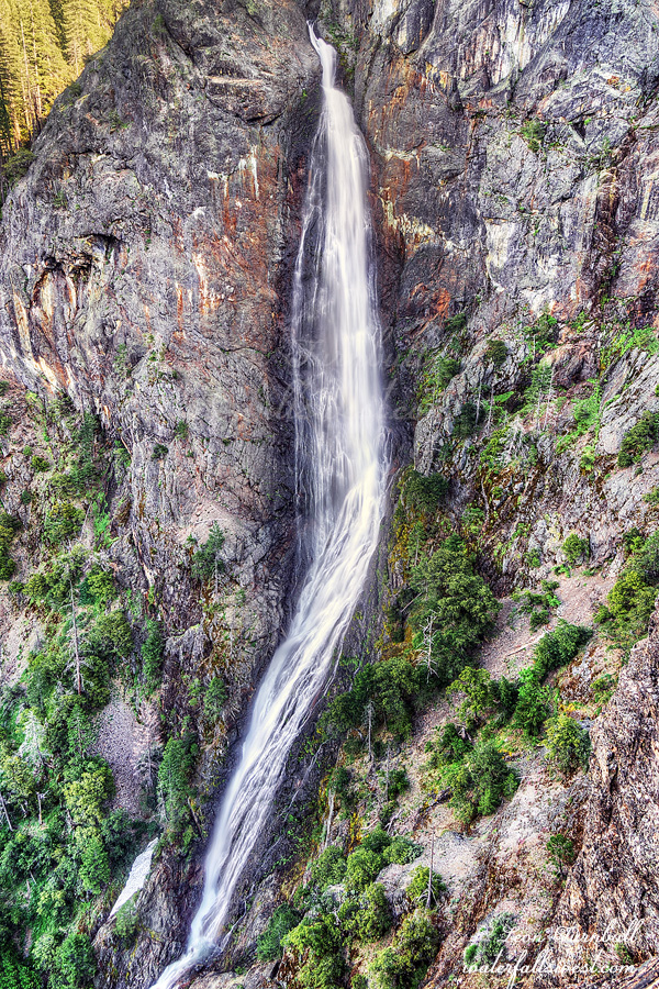
It was not difficult to get down to the waterfall. The snow had disappeared and I had taken off the snowshoes. It was not cliffy. However … getting a view of the falls was a lot more difficult than I anticipated or hoped it would be. It was extremely brushy beside the creek. I had to clamber through very thick brush on a steep slope to get to the creekside. I crawled out on a log in the middle of the creek and I finally had a good view, but at this spot it was very misty so it was a huge challenge taking a photo. I managed to get something.
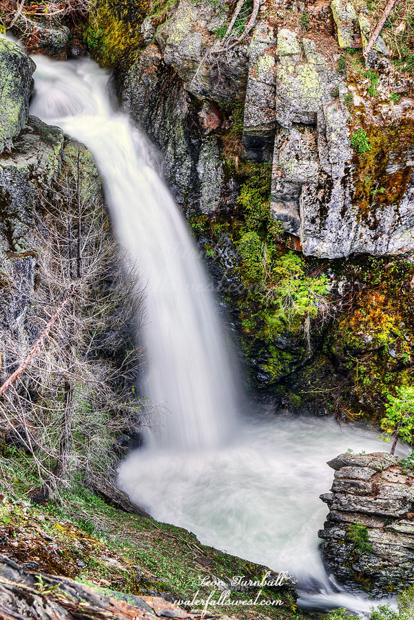
I’m not so sure it was worth the effort. This waterfall I am calling Upper New York Canyon Falls East. It is 53 ft. high. It looked a lot bigger from a distance on Sailor Flat Road. Anyhow, it is an interesting one. I climbed back up the hill and to my car.
On the way home as I got back to Tadpole I saw that the lady and her kids were still there. It was 3 hours later. I almost passed them by again without stopping. It did not occur to me that they could have been stuck. They were parked just two feet off the main road. As it turned out they were indeed stuck and there was no possibility of pushing the car out of it. Thankfully she said there was someone on the way to help and it would not be very much longer, so I said goodbye and left. It kind of boggles my mind why she thought she could drive up this road with so much snow on it. She literally drove two feet and was completely stuck. Sigh.
So remember a couple weeks ago I said I was really bummed because on the day I was planning to go to this waterfall they turned off the tap? Well they turned the tap back on this week. I figured this would be my one and only chance this year to see this waterfall. It was Memorial Day weekend.
What the hell was I thinking!!! I never go anywhere on Memorial Day weekend. There are too many people. I hate crowds. I hate horrendous traffic. Driving down to Shaver Lake the traffic was absolutely horrific! I was stuck going 5mph for about 50 minutes. I had enough. I was ready to go home. Once I finally got past this section I exited the freeway. I needed a break. I needed a bathroom break. I needed a dinner break. I needed a reset. Well after checking my map I figured it would be a two hour drive back home. And it was two hours to Shaver Lake. Going back the traffic would definitely be bad. Continuing on it did not seem there were too many more slow spots. I felt recharged a bit after dinner. I decided to continue.
When I arrived at Shaver Lake I needed to find a place where I could sleep in my car. Off the beaten path. With no one else around. On Memorial Day weekend. I drove to the place where I would be starting my hike in the morning. It was a good spot to park and sleep. No one else was around. Indeed I saw no one at all out in this area the entire weekend. I was shocked. It is Memorial Day weekend! I definitely expected to see some people out camping or hiking somewhere the next day. Nada.
I got up at 4AM to start my hike in the dark. I had until 7:30AM to get to the waterfall and I figured it would take 2-3 hours to get there. I had to make sure I had enough time. So off I went in the dark.
In very short order I came across a massive road block. Actually, it was a road massacre. There was no road! A flood had completely wiped it out. There was a small stream running down the middle of the road with 30 ft. canyon walls on each side. I am not exaggerating. This new canyon was probably created in just 2 or 3 days. I had the understanding that this road was closed due to damage from the Creek Fire and that may have been the case but now it has been destroyed by a flood. I suppose it could have been from 2017 floods but I suspect it was from this year considering all the other damage that has occurred this year, especially in Sierra National Forest (where this is). It is incredible what a small flood lasting just a couple days can do. I wonder what a massive flood of 40 days and 40 nights could create? Oh yeah, we can see the result of such a flood now, can’t we? It’s in Arizona.
Anyway, I was really wondering if I could even get by this little canyon, in the dark. Fortunately I was able to. After this, however, the road did not get any better. Every small stream coming down the side of the mountain (whether it was still flowing or dry) had taken out a massive chunk of the road. The damage to the road overall is unbelievable. I was able to get by all these sections, however, there was one spot that was very narrow and I had to crawl on my hands and knees. Coming back across this section later was a lot sketchier than I thought it would be, with a big drop-off to the side of it. Crawling would not work so I had to jump across the drop-off. Do you think I am a Madman now???
As the sun came up I could now see across the canyon to my left and hear the river roaring. Oh wait, that is not the river. That is Stevenson Creek! The views along here were spectacular. I had no idea Stevenson Creek flowed through such a beautiful canyon. It would be a great place to camp. The upper falls was looking very impressive from a long distance but I would not be going there today. I continued down the battered and beaten road.
I had to exit off the road now and descend about 500 ft. to my viewpoint. I could see the waterfall from near the top and could have taken pictures from there but I could not see the bottom of the waterfall so I wanted to make the effort to get all the way down as planned. It was not cliffy or brushy but the foxtails were horrendous. I should have been wearing gaiters. I was not wearing gaiters. Ugh. I made it down to the viewpoint. It was 6:30AM. (an hour ahead of schedule).
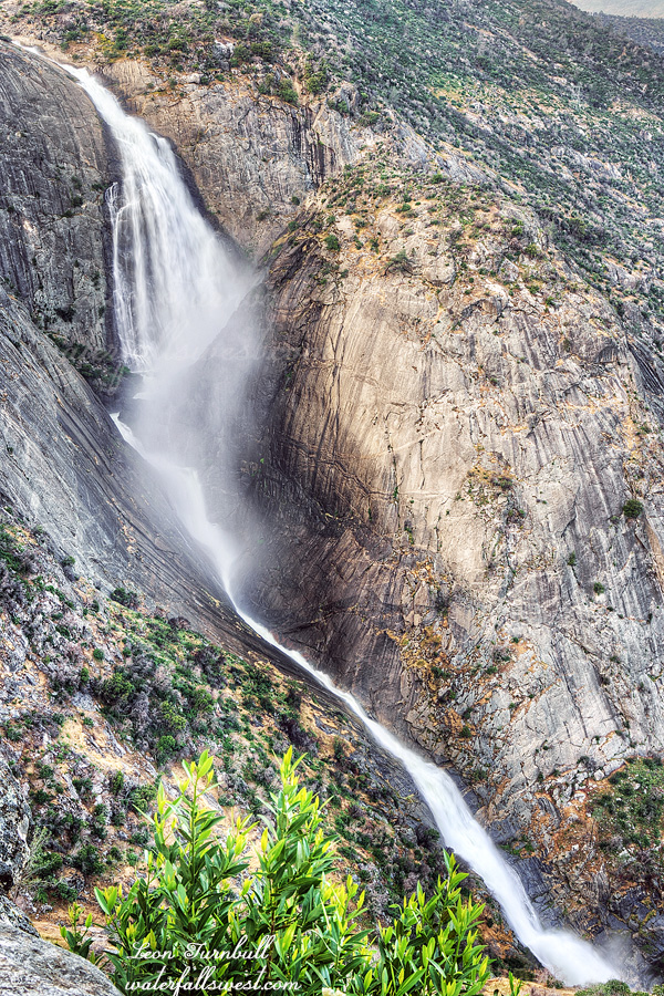
Stevenson Creek Falls was massive! Wow! What a view! What a waterfall! The flow in the creek was 500 cfs coming out of Shaver Lake. This upper drop I measured to be 518 ft. high. I could also see the lower falls dropping onto the bridge from here. I could see the entire 1175 ft. waterfall from here. I took many photos. This is the first one, just showing the upper massive drop. I could see the waterfall overflowing onto the bridge below. I did not see any people down there (I wondered if there would be any but I guess not at 6:30AM). I have seen recent posts from people going to the lower falls and then not being able to cross the bridge because of all the water overflowing onto it. I have done that before myself. It is funny to me. Everyone hikes to the lower falls but you cannot see the upper waterfall from there (even if you can cross the bridge). No one hikes to the upper falls as I did on this day. Indeed, I expected there to be a good path down to the viewpoint but there was none. I’m sure someone must have done this before but I have not seen any photos from anyone. This is the only place to see Stevenson Creek Falls. I win!
I spent an hour at the viewpoint and ate my breakfast here. Afterwards, I felt I should have stayed longer. An hour did not seem to be enough to enjoy this spectacular waterfall. I climbed out of the canyon. Once back on the road I spent a good 30 minutes removing all the foxtails from my socks and boots. I hiked back on the massacred road to my car. I drove to Pizza Factory for lunch. I drove home. (the traffic coming in to Sacramento was horrible – ARGH). It was an absolutely spectacular morning visiting Stevenson Creek Falls in Sierra National Forest.
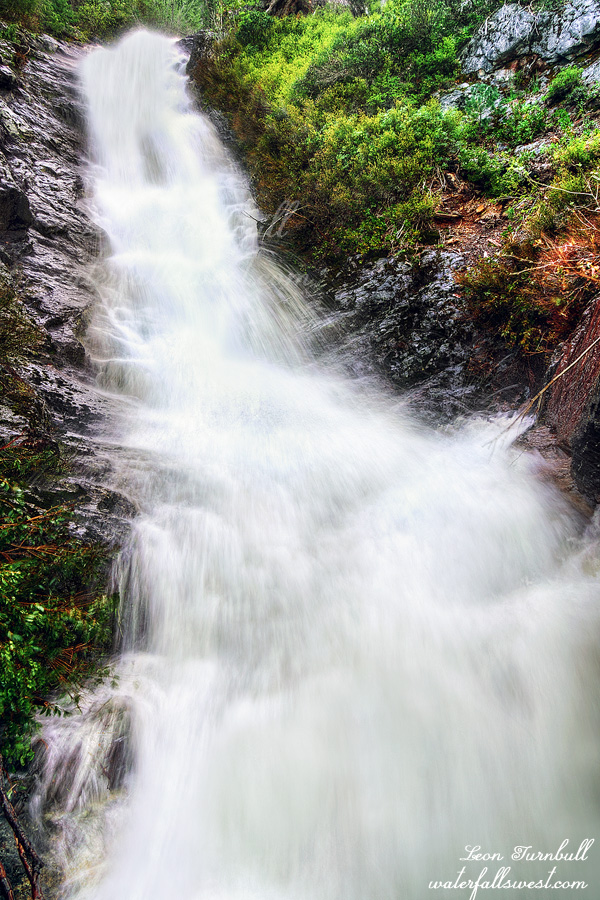
This is Little New York Canyon Falls, 33 ft. high.
I did not sleep very well. My guess is because my back was hurting too much and I could not get comfortable.
I woke up very early. I wanted to try to get to a new waterfall that I saw on the way down and had not been to before. I thought I made great time climbing 1100 ft. back up the mountain but when I reached the waterfall it was already in full sun. It was only 7AM. Darn it! Well I guess I’m going to have to come back here sometime in the evening before this one dries up for the year.
I found my snowshoes that I left behind the previous day and started hiking back up the Sailor Flat road. This section seemed to take a very long time even though it is only 1.5 miles. Maybe it was the snow. Maybe it was because I was already tired from climbing 1100 ft. out of the canyon. Maybe it was my back. Maybe all of the above. I finally got back to Foresthill Road and pavement. The 4.5 mile road walk back to Ford Point also took an excruciatingly and horribly long time. I sure hope they open this road back up. I’m not hiking from Ford Point again that is for certain. I arrived back at the car by about 10AM and drove home. It was an absolutely amazing overnight trip to see my favorite waterfall.
If you ask me what my favorite waterfall is I will likely say New York Canyon Falls. It is not necessarily clear cut but I love this one because it is so remote and so hard to get to. It is also magnificent. This would be my seventh time.
I have seen it at peak flow before but not from the closeup viewpoint at Chert Knoll. The last time I was there the flow in the North Fork American at the dam was about 2400 cfs. I said the next time I come will be when the flow is at least 4000 cfs. Six years passed. Enter 2023. Epic winter. Snow pack at 200% of average. I was watching the flow all week. It was hovering around 4000 cfs. On Saturday it was 5100 cfs! We have lift-off!
I figured I should be able to drive to Tadpole and hike from there, as I usually do. The road was closed at Ford Point. There was no snow anywhere. Why the heck is the road closed!?!?! Indeed they had plowed the road all the way to Sailor Flat. I could have easily driven all the way to my trailhead. Instead I had to walk 4.5 miles along the road. Of course the road closure did not stop people from driving up there. I saw many cars go by me. The rules do not apply to these people, you understand. On the way back I saw a ranger drive up the road. I was going to stop him and ask why the road is closed but I never saw him come back down. I did see one car drive back in shame shortly after. Whether he had a ticket or not I do not know.
At Sailor Flat there was a ton of snow. Probably about 5 feet. I was expecting this of course and I had my snowshoes with me. Snowshoes were an absolute necessity. It is actually the first time I’ve used my snowshoes this year, in this epic year. It won’t likely be the last. There is still a lot of snow out there. The snow disappeared by the time I got onto Macklin Ridge, which I named after my friend Rob who discovered this great route down to New York Canyon Falls. I dumped the snowshoes and continued down the ridge.
It is a 1000 ft. descent to the creek crossing and my camp. This is when things got really interesting. In order to see New York Canyon Falls you must cross the creek above the waterfall. Above the 500 ft. high waterfall. When the flow was at 2400 cfs it was very easy to cross the creek but now the flow was more than double. Would it still be safe to cross? Above the 500 ft. waterfall. The creek was flowing very strong. It did not look too promising. HOWEVER … there were logs across the creek. I went to check them out and tested the crossing. Easy peasy. No problem. I went back and set up camp and relaxed for the afternoon, knowing I would easily be able to get across the creek in the evening and get down to the waterfall. Huh. But nothing is ever easy for the Madman, is it.
After dinner I started my journey down to the waterfall. I crossed on the logs. Easy. After crossing, as is my custom, I set up my camera for the video and went back to do it a second time. That is when I see a huge rattlesnake. On the logs! I literally must have stepped right over it and not seen it. Now it was woken up and it was starting to slither towards me. I retreated quickly. I continued my hike into the brush and only two seconds later I hear a loud rattling sound. There was a second one! I did not see where it was. Where the heck is it? I backed up very quickly and then I saw it. Now I was in between the two snakes and the first one was probably still coming towards me. I went wide around the second one, looking very carefully for any more. I am certain these two snakes lived right here and there were probably babies around as well. Holy crap! Now I am wondering how the heck I am going to get back across the creek!
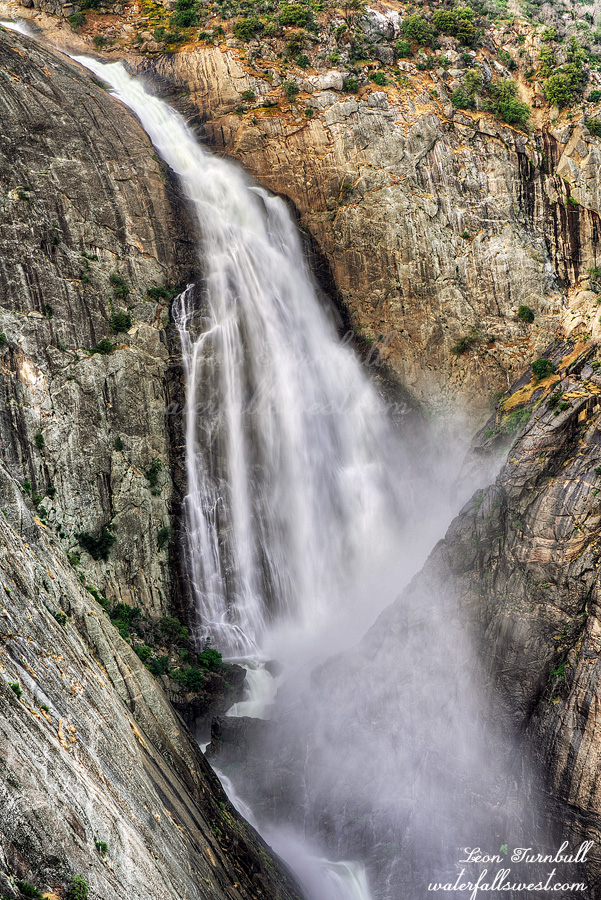
Well I tabled that thought and continued down to the waterfall viewpoint on Chert Knoll. New York Canyon Falls was absolutely magnificent! This was certainly the best I have ever seen this waterfall. It is 540 ft. high (new more accurate measurement). Going off crazy at peak flow with the NFAR at 5100 cfs. It was a stunning sight. I had to wait a couple hours for the sun to go down so I laid down to rest my back. Initially I was going to see another falls in this area but my back was hurting too much so I just went down to see NYC only.
After taking my photos I made the climb back up the mountain. I had decided there is no way in hell I was going back into the snake zone. That left me with one option: Wading across the raging creek. Death by snake? or Death by waterfall? What would you choose? I chose waterfall (of course). The creek crossing was definitely on the sketchy side. There was a strong pull but really it was not too bad. I made it across without any trouble. I returned to camp and went to bed.