
I woke up in the middle of the night to use the facilities. Outside my tent I saw a huge spider on the ground. I did not think anything of it. It looked harmless. I took a step away from my tent and towards it to go find a place to pee. All of a sudden the spider went into attack mode and came towards my feet at lightning pace. I stepped back just as quickly. Holy freaking mother of all things evil! What the heck was that? It was right near my tent door so I closed off my tent so it could not get inside while I went in a different direction, never taking my eyes off where it went to. Needless to say, I also checked my shoes in the morning that were left outside my tent.
It was a short hike up from Lone Pine Creek Falls to Tamarack Lake but a lot of elevation gain (1600 ft.). The trail to Tamarack Lake is quite overgrown. I am not impressed with the park service. This is an official trail in the park but seems to be completely neglected and unmaintained.
When I arrived at Tamarack Lake I was greeted by a million angry customers that are named mosquito. They were absolutely horrible. This was the first problem I have had with the little monsters all trip. I had some but not many at Nine Mile Creek, very few at Hamilton Lake, none at Nine Lake Basin, none at Lone Pine Creek, and now this nightmare at Tamarack Lake. Why?? I was not expecting to find any at Tamarack Lake because it is higher elevation than the other locations. Afterwards, from reading other hiker’s reports, I came to a realization of what I think happened: ALL the mosquitoes hatched on this one day (at least in this area of the HST – but it seems in other areas of the Sierra Nevada also) and now they are out in total invasion force. Someone said that it seemed to him that in one day the mosquitoes finally downloaded the full mosquito instruction manual and finished reading it. That seems an appropriate description to me.
I had to hide out in my tent all afternoon to get away from the buggers (and I was not the only one there that had to resort to the tent retreat). Fires are not allowed at Tamarack Lake so that was not an option. It was another hot day. I set up my tent beside some trees, thinking they would give me some shade and relief but I guess I miscalculated where the sun would go in the afternoon because it missed the trees and was shining directly on my tent. I propped up my tent pad so it would block the sun and that gave me some shade in the tent. There was also some breeze which helped. I was able to nap in the afternoon.
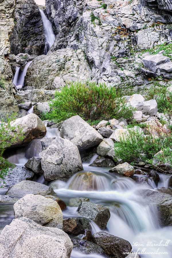
In the evening I went up to see the waterfall at the inlet to Tamarack Lake. It was not an easy adventure. I first had to wade across the outlet stream. This was not difficult but I did have to wear my water shoes and then on the other side put my hiking boots back on. This allowed the mosquitoes enough time to gather their forces for a full out attack. Beaten but not deterred, I continued on to the waterfall. There is a huge rock slide that you need to climb up. The boulders are enormous and it is difficult and potentially dangerous to climb them but I managed to find a safe way through (I was not expecting that I would be able to do it). When I got close to the waterfall I came to a wall of thick brush that was impassable. There was no way through. I decided to cross the creek and try the other side. I climbed up to a ledge that I thought was going to give me a glorious view of the waterfall but instead there was a rock wall that blocked off half the falls from view. Dang. This was no good. I went back across the creek and tried the brush again. This time I found a way through (it was not easy), and finally came up to the waterfall. Magnificent Tamarack Lake Falls, 80 ft. high. Here also was the only place at Tamarack Lake where I found little or no mosquitoes. Relief! How do you spell relief? (side note: who is old enough to remember that commercial and can tell me what it was for without looking it up?)
Alas, I had to get back down to my tent before dark. I hurried back through the brush and past the boulder field and crossed the outlet stream to my tent. Now it was dusk. There were five million mosquitoes at my tent waiting for me. As quickly as possible I got ready for bed and crawled into my tent, trying to keep all the monsters out. A few got in but I fought back with my machine guns and shored up my defenses. Then I realized I left my phone and Inreach outside. Ugh. I had to go back out to retrieve them. I barely survived the second assault. Good night day 5.
Posted in Southern Sierra, Waterfalls by leapin26: June 19, 2021
My plan for this day was to hike back over Kaweah Gap Pass and on to Tamarack Lake. Not quite.
I arrived back at Precipice Lake at 9AM. I was shocked to see backpackers up here already from Hamilton Lake. They seemed to be hiking very fast (which is impossible on this steep rocky terrain) but they must have started hiking extremely early. I think it took me 3 hours to get up to Precipice the previous day, though I’m not the fastest hiker in the book. Even going back down to Hamilton Lake took a very long time.
It was a very hot day. I got to Lower Hamilton Lake Falls at around noon and had my lunch. There was just a tiny bit of shade to sit down and rest. I was very tired already and I still had 2000 ft. to climb to get up to Tamarack Lake. It was not going to happen. I decided to change the plan. I could have made it to Tamarack Lake if I really had to but I thought of a much better plan which was to camp at Lone Pine Creek Falls. The first problem: it is very rocky at Lone Pine Creek Falls and there is no place to setup the tent. I searched all around. I did not want to continue hiking any further. Finally I found one small space that would have to make do. It was going to be a bit of a rough night in the tent (not too bad though).
The second problem: there was no shade whatsoever at this campsite. I was burning up! I found a rock to hide behind and got into a semi-comfortable position to sit down all afternoon. The occasional ant would climb up on me and bite me (I hate that!) but I managed to relax for the afternoon.
In the evening I crossed the creek and went up to the waterfall. Lone Pine Creek Falls is a gorgeous tiered waterfall 100 ft. high. You can see it from the HST but it is off the beaten path and no one would want to take the time to go see it up close (it is not a good camping spot as I said, plus everyone wants to get up to Hamilton Lake). I had a very relaxing time at this waterfall. I could really take my time and enjoy it and took many photos. I was all alone at Lone Pine Creek. Good night day 4.
Posted in Southern Sierra, Waterfalls by leapin26: June 16, 2021
I did not sleep well on night 2. My legs were sore and uncomfortable all night long. This is what happens when you get old (for all you young ones out there). Usually I take electrolytes to help but I did not do that on this night. Lesson learned. I slept fairly well on every other night.
I was up early as were the other groups at the lake. It was a beautiful morning at Hamilton Lake. No clouds in sight (yet). I made my breakfast and drank my coffee. Then I used the facilities. There is a pit toilet at the lake. It is a funny one because it is open with no sides. I guess it is like this so you can see the bears coming for you as you sit on the pot. This does bring up another irritating point though. I noticed that some backpackers just left their toilet paper out in the open, hidden under a rock (as if that helps), and in one case just left beside the trail out in the open. Argh! Why do people do this? There is a pit toilet right here. Why can’t you just put your toilet paper in it? That is why it is here! Leave no trace, people. Please. It is so easy to pack out all your garbage, including your toilet paper. (if there is no pit toilet).
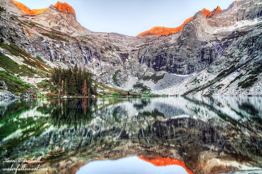
It is a tough climb to the top of Kaweah Gap Pass. It is a 2500 ft. elevation gain. It took a very long time, mostly because the trail is so darn rocky. I hate climbing up and over rocks built as steps on the trail. It is about 5 times the effort to lift your leg over a rock, as opposed to just climbing up a dirt path. You also cannot go very fast; probably I was going about 1 mph. Along the way you pass stunning Precipice Lake. At 10,300 ft. elevation the lake still had ice in it. The top of the pass is at 10,700 ft. elevation. When you look across to the other side the view is absolutely magnificent. You can see down to the lake in Nine Lake Basin, the big waterfall in Nine Lake Basin, and down into Big Arroyo. And of course there are the magnificent mountains including Black Kaweah and Kaweah Queen.
My plan was to camp in Nine Lake Basin and go up to the big waterfall in the evening. Initially I wanted to camp beside the gorgeous lake. However … I “knew” another thunderstorm was coming in the afternoon. I could already see the thunder clouds building up in the distance. They would make their move in the afternoon just like the previous day. There is zero shelter at the lake. No trees at all. It is completely exposed. I needed to find something that was somewhat sheltered. This was not an easy task but I found a decent spot by a small waterfall (never a bad thing to camp beside a waterfall). OF COURSE … that storm never did come in the afternoon. The clouds just hovered off in the distance, slowly building up strength all afternoon. They were just about to make their move and in fact did start to move towards me … and then they just all went away. Stranger things!
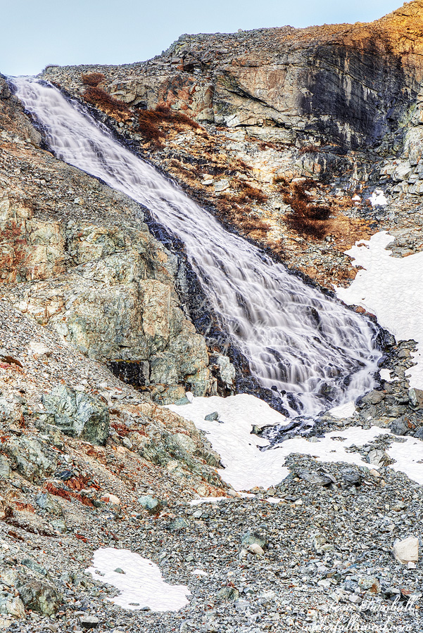
In the evening I hiked up to Nine Lake Basin Falls which is at 11,300 ft. elevation. (my camp was at 10,500 ft.). It is a beautiful 100 ft. high waterfall in a gorgeous high elevation setting with snow still around it. Once the sun went behind the mountains it became very chilly and of course I left my warm jacket back at camp. I took my photos then hurried back down, arriving back at my tent just before dark. Good night day 3.
Posted in Southern Sierra, Waterfalls by leapin26: June 12, 2021
I slept well the first night. I got up early and made my breakfast. The other backpacker (who was going back towards the trailhead) had already left but the one going in my direction was still sleeping.
As I was about to put on my backpack and hit the trail a couple deer came right up to me, within 6 or 7 feet of me. They had no worries about me being there whatsoever and began to lick my pee. Yes, you read that correctly. It was so hilarious. I watched them and talked to them for about 10 minutes. They were still licking it after I put on my backpack and left.
I was the first to arrive at Hamilton Lake at around noon and snagged the best campsite at the lake. Am I greedy? You can call me that if you wish, and I suppose I am, but there are only two or three really good spots at this lake and it is a very popular place to camp (there are a few other spots that are not as nice). Speaking of which … there is a one night limit for camping at Hamilton Lake because it is such a popular spot. I saw at least a couple people going up from Hamilton to Precipice Lake for a day hike and then were staying at Hamilton Lake for two nights which is against the rules. This is NOT OK, folks. There will be more hikers coming up the next day and if you have taken one of the better campsite locations then they will have no place to camp (or have to camp in one of the crappier locations). If you are going to do this you should at least have the courtesy of taking one of the crappier spots. The rules apply to everyone and are there for good reasons.
The solo backpacker doing the entire HST and the girls came up to the lake in the afternoon. The other couple never showed up so I guess they ended up going somewhere else but another guy came up later, so there were three other groups at the lake. On the other side of the pass I could see storm clouds slowly but surely building. At 3PM they made their move and started moving in towards us. Something wicked this way comes. I decided to make my dinner quickly before the rain started. Thunder started to boom as I ate and the rain started just as I finished eating. I quickly cleaned up and got everything and myself into the tent just in the nick of time. This storm was absolutely intense! For 30 minutes the wind was howling against the tent and the rain was pelting down. It was the craziest thunderstorm I have ever experienced while camping (there was one we had while family camping in Oregon that may have been worse). I was certain the wind was going to tear my tent apart but the Zpacks held up incredibly well. Everything was dry and held together.
The storm finally abated and I stuck my head out of the tent. Blue sky! Were the girls ok? I thought I should be nice and check on them. They did not even have their tents setup yet when the storm started and it was such an intense storm and came on quickly. Afterwards, I remembered reading something recently that was talking about backpacking girls not needing any help from men. I think that is bull crap. Everyone needs help sometimes, both men and women. Can’t a man be kind anymore? All I did is ask if they were ok. I’m not sure if they thinking about that article, I don’t think so, but who knows maybe they were thinking it.
After the storm I went exploring for a bit and when I got back I saw the girls in my campsite taking photos of something. It was a marmot, apparently trying to get into my bear canister. I must have seen about 1000 marmots on this trip (give or take). They were absolutely everywhere and some of them were fearless. Crazy little things. I remember when my daughter was a baby and one tried to kill her (I’m joking but interestingly that was also in Sequoia NP).
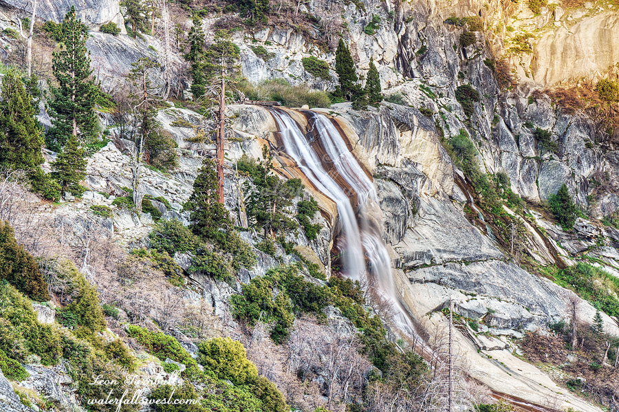
In the evening I photographed four waterfalls, the two lower falls, the middle falls, and this one at upper Hamilton Lake at sunset. I was really happy with how these waterfalls were flowing. It sure made up for the previous day. Good night day 2.
Posted in Southern Sierra, Waterfalls by leapin26: June 10, 2021
This was my fifth and last and biggest backpacking trip of the spring. I had hoped to get in six trips but that was a bit over zealous of me, especially with my injured feet. Five trips is a huge success in my view.
This would be a 6 day backpacking trip on the High Sierra Trail in Sequoia National Park. Six days is the longest backpacking I have ever done thus far (my previous longest was 5 days). I would not be hiking the entire High Sierra Trail. I have no interest in doing that (at least not right now). My interest is in doing a section of the trail to see ALL the waterfalls in that section. I would not be able to see all these waterfalls if I was hiking the entire trail. I saw 11 waterfalls in the 6 days.
I arrived at the Giant Forest Museum in Sequoia National Park to get my permit at a good early time. There were three people ahead of me. One of them had an invalid permit (due to his own mistake). The ranger was a nice guy and was trying to get him a valid permit but it took 45 minutes! I appreciate him being nice but he should have made the guy wait until the others behind him in line could get their permits (there were 2 others behind me also). This basically delayed me an hour in starting my hike.
Well, it was not really a big deal because I was only planning to hike about 6 miles to Mehrten Creek. I arrived at Mehrten Creek about noon and ate my lunch. My plan was to camp here and see the two waterfalls in the evening. However, Mehrten Creek was essentially dry. I was surprised and disappointed. I know we are in a drought this year but it is only early June. I was not expecting much but the creek should have still had decent flow. How is this going to fare for the rest of the waterfalls on my trip? It was not worth photographing the Mehrten Creek waterfalls at all so I decided to push on to Nine Mile Creek. This would make my hike for the second day a bit shorter. Nine Mile Creek is actually at the 10 mile mark, not the 9 mile mark. I found that the park trail signs were always off the actual mileage. They said it was only 5.2 miles to Mehrten (one example) but according to my GPS it was 6.6 miles.
Along the way to “Nine Mile Creek” I came across a rattlesnake right on the trail. I almost stepped on it. Unfortunately, that was too close for the snake’s comfort and it started rattling at me in earnest. Step back! Step back! Ok! Ok! Thankfully, it moved off the trail and into the bushes.
I arrived at Nine Mile and set up camp. It was a big buggy with gnats and mosquitoes so I made a fire to keep them away. Camp fires are allowed here (but not above 9000 ft.). The mosquitoes were not “horrible” (we will have more discussion about mosquitoes later), but even a few is bad so a fire works well to keep them all away. A couple other hikers arrived at the camp a bit later, one going back to the trailhead and one going the same direction as me (he was doing the entire HST). Also, a group of girls passed on by and another couple as well. So that means I expected to see about 3 other groups at Hamilton Lake the next day. There are not a lot of great camping spots there so my plan was to get up early and hike the remaining 7 miles to the lake, beating the other groups there and obtaining the best spot at the lake. That was the plan.
I got in my tent early and watched a movie. At dusk a large group of deer passed through my campsite. I could see them from inside my tent. They could see me as well. The look on their faces was funny when they saw me peering at them through the tent mesh: “Why is he looking at us?”.
I did not see any waterfalls on the first day so this photograph is from the second day: Lower Hamilton Lake Falls. I really really really wanted to get down to the bottom of this falls. I tried about 3 different ways but it was a NO GO. It was just way too cliffy and steep and brushy. No wonder I have never seen any photo of this waterfall from the bottom before. Nevertheless, it is not a bad view from the trail. Good night day 1.
Posted in Southern Sierra, Waterfalls by leapin26: June 8, 2021
