Wake up 3:30am. Drive to Feather Falls trailhead. Arrive in dark. Start heading out to the waterfall.
Sound crazy? Nuts? Insane? Wait til you hear the rest of the story.
First off, this may be TMI but when I arrived at the trailhead I had to use the outhouse facilities there. I noticed a rat crawling around down in the hole. I’m not kidding you. Needless to say I went very quickly.
That was the freakiest thing I saw this day. Which is probably good because I was biking in the dark. Not hiking. I was hoping to be at the falls by sunrise and since it is about 5 miles one way, biking is the quickest option. It is actually a very nice trail to bike, going out is mostly downhill, but fairly gentle, so coming back afterwards is tough but not killer. It is easier to hike out and back but much quicker to bike.
I was also trying out the new camera I just bought. A GoPro Hero head cam. Why would I get such a thing? Well, I have a grand idea of documenting my hikes for the public to view and follow me along. This one is going to be really good I think and definitely not boring, so be watching for it soon.
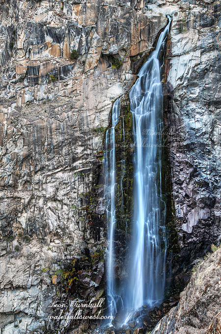
I arrived at Feather Falls a bit later than I wanted. I first went down to the viewpoint. The falls was flowing really quite well, much better than I expected. This late in the year and after two years of drought I thought it would be as low as I have ever seen it. Not so. It was exquisite.
After photographing from the viewpoint it was time for part two of my adventure: crossing the river above the waterfall and try to find a spot on the other side to photograph it. I have never seen a photo of Feather Falls from the other side. Now I know why. (actually I lied – I have seen one very very old photo, but that is it).
I figured the worst part by far would be crossing the river and with the falls flowing higher than I expected, I thought it might be impossible. People have died here including one last year. It is kinda freaky crossing a river above a 410 ft high waterfall but actually it was very easy (don’t try it in the spring though).
Next up was to climb the ridge on the other side and make my way down to a point where I could see the falls. After studying Google Earth I really expected this to be a piece of cake. It looked so open and non brushy. Not quite. It was extremely brushy. I found a trail going in the right direction and thought I would be in luck. At first I thought it was a human trail but after awhile (and after passing a number of bear droppings) I realized it must be a bear trail. Eventually I was stopped by the brush. I could go no farther but I did get to a point where I could see the waterfall. It was too obscured to take a picture but you will see it in the video. So it was not a huge success but at least I got a view of the waterfall (albeit somewhat obscured).
The bike ride back to my car was quite tiring (it didn’t help that I did all that scrambling on the other side of the river). All uphill and 5 miles, but I made it all the way. It is a good thing I am in shape right now from biking to work every day. Otherwise I might still be out there on the trail somewhere.
Posted in Northern Sierra, Waterfalls by leapin26: October 27, 2013
Here you go folks: A brand spanking new waterfall just found in Lassen Volcanic National Park. It is a nice one and a significant drop too at 50 ft. high. Thank you very much, Mr. Amazing and Crazy Waterfall Hunter at waterfallswest.com!
I say that last sentence in jest because of a recent high profile news article in which a certain canoeist in Canada found a previously unknown waterfall while canoeing down a remote river. He claimed it was 40 ft. high but from the picture I saw, it was clearly only around 20 ft. high, and likely less than this! Now he is getting paid money by the Royal Canadian Geographical Society to find waterfalls in Canada. I did not say anything about this previously, but I really thought the whole thing was very lame. I mean, heck, I find new “uncharted” waterfalls all the time. Last waterfall season, for instance, I found Upper West New York Canyon Falls (and it is 150 ft., not 20 ft.), not to mention quite a few others as well (oh I could mention some of them: SF Rubicon River Falls, Upper Clipper Crk Falls, Upper Iowa Cyn Falls, Upper Devils Falls, Iowa Hill Ditch Falls). And I am not the only waterfall hunter that finds new waterfalls. It is not difficult if you know where to look, and have a lot of determination. So it kind of bugs me that he finds a 20 ft waterfall and now gets paid for doing it. One thing I guess I can say about him is that he is a lot smarter than me if he can scam RCGS into paying him to find 20 ft. high waterfalls.
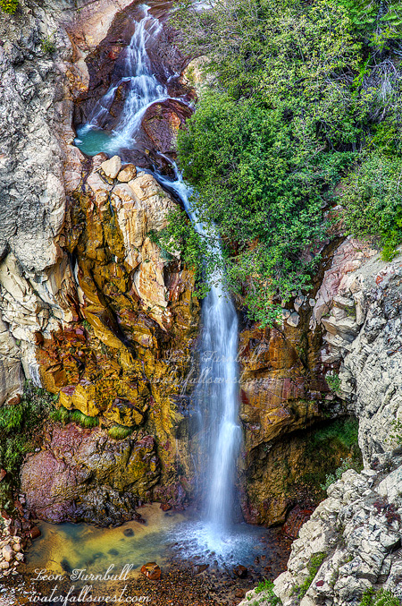
This season (which has only just begun) I now add yet another one to my list, which I am naming West Sulphur Creek Falls. Although not far from a main trail, it is hidden and rather remote. I am quite certain that no one currently in the park service has been to this waterfall or even knows of its existence. I saw no evidence that anyone had been down there in the recent past. Of course I am not foolhardy enough to believe that I am the first person to ever lay eyes on it (I am only slightly foolhardy). In fact, I saw what seemed like a very old road down there but it was so old I am not sure if it even was a road, and certainly has not been used in over 100 years. And if anyone did see it in the past, it was probably just swished away, discounted, ignored, snubbed – even though it is a significant drop at 50 ft. high. That is because it is hidden in an extremely steep canyon, surrounded by cliffs on both sides. The cliffs seem even steeper than those at Mill Creek Falls – and we all know what those are like (see my previous post). It was very difficult to get any view of this waterfall at all, I was standing on a hairy scary precipice, and even then, the top part of the falls is obscured by tree branches, so from this viewpoint it is not very photogenic, but it would be sweet if you could get down to it. It may or may not be possible to do that; I would like to come back and try someday, but I did not have time on this day as I had to get to Chester to meet up with my family for lunch. Oh and by the way … there are more “uncharted” waterfalls in Lassen NP, and some of them may even be a lot bigger than this one.
It is of course rather a huge shame and disappointment that Lassen NP is now closed because of the government shutdown (as well as all other national parks). So now you can’t even go to this waterfall (at least for awhile). It is very irksome for sure. Even the trails are closed. I just don’t understand that. I could understand closing the facilities, but why the trails? Why can’t we still go in there and hike? This is our land, people. Not the government’s.
Posted in Lassen, Northern CA, Waterfalls by leapin26: October 1, 2013

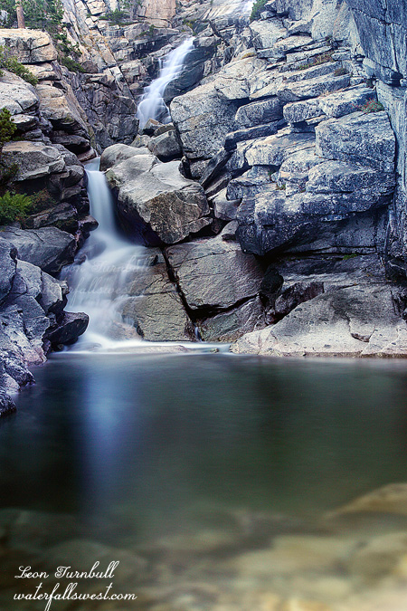
Five years ago I went to Mill Creek Falls in Lassen Volcanic Natl Park with my friend, Brian Rueb. At that time, we both wanted (badly) to try to get down to the bottom of the waterfall. At that time, we both determined that it was foolhardy to do so, nuts, crazy, whacko, you name it. The terrain from the viewpoint on the trail is incredibly steep down to the bottom. As Brian put it, “things would not go well for you if you tried it”. However … shortly afterwards another friend of mine, Rob The Mountain Goat Macklin went to Mill Creek Falls, and he DID get to the bottom of the waterfall. Both Brian and I thought this was unbelievable craziness. But I know Rob well, and I know how he got to the bottom. No ropes. Just straight down the cliff. He is part mountain goat, you know – I am not kidding.
So five years pass, and I figure it is time to do this. In my mind I determined it could not really be as steep as I thought it was five years ago. The terrain is probably much tamer now. Five years of geology will have made the descent much shallower. There WILL be a way to get down. Well, not so much. I did come armed with a rope this time. When I arrived at the viewpoint, I quickly realized I would certainly need it too. The terrain was not any shallower, that was for sure. With the rope, I made it about halfway down to the bottom or perhaps a bit more than that. But the last section is much worse. There is nothing to hang onto, nothing to tie my rope to, and the descent is incredibly sketchy. It would be a long fall into nothingness if I slipped. I hummed and hawed for awhile, and decided to stop while I was still able to. I took this photo from halfway down the cliff, so the view angle from here is a little different and a little better than from up top along the trail. But darn I wanted to get to the bottom. Will I try again? In another five years? Yes I will. Next time … I will be bringing a much longer rope, one that will reach all the way to the bottom. Will that be enough?
The trail to Mill Creek Falls is not an easy one. It is 2 miles one way (though the sign says it is only 1.6 miles – it is not), and there are a lot of ups and downs on the hike (up 300 ft, down 200 ft, up 50 ft, down 100 ft – you get the idea). It is a huffer. But while as five years ago I remembered the hike practically killing me, this time around I found it to be a walk in the park. It may have something to do with the fact that last time I had climbed up Mt Brokeoff the night before, but I think it is mostly because I am in much better shape. I have lost 20 pounds in the past 6 months, and I feel great, I am in the best shape I have been in the last 14 years. It is so awesome to be able to bike to work every day now. It is such a big difference.
Another thing I noticed that was different from last time was the trailhead sign. This time around, there was no warning sign about mountain lions. It looked like someone had scratched it completely blank. Did the resident mountain lion move on to another part of the park to prey on unsuspecting hikers? Or more likely, perhaps it was the mountain lion himself that scratched off the warning sign – in order to make the hikers along the Mill Creek trail more unwary of being attacked? I joke about that but I did see some mountain lion tracks on the hike this time around. I am not kidding – I am pretty sure they were cat tracks. Hmmm.
Stay tuned folks because my next post from Lassen Volcanic Natl Park is going to be a shocker.
Posted in Lassen, Northern CA, Waterfalls by leapin26: September 29, 2013

This is yet another of the many marvelous waterfalls in the Rainbow Pool area that was recently ravaged by the Rim Fire. This is the third waterfall on the South Fork Tuolumne River, plus the one on the Middle Fork makes four waterfalls in this one location. Such an amazing place. And hopefully it still will be. I measured this falls to be 26 ft high, though it seems a bit smaller to the eye when you look at it. The first time I was here last year, I missed this one because the road was blocked by a huge landslide. The landslide was happily cleared away this year and I could get down to this little dude. Sweetness.
Posted in Northern Sierra, Waterfalls by leapin26: September 3, 2013
If you know this location and if you are looking closely you may be wondering how this image was taken. You should be wondering. It is an impossibility. Well, not really. I guess that is obvious. But in reality, for most of the year it *is* an impossibility.
My goal was singular. Cross Pyramid Creek at the bottom of Horsetail Falls and photograph the waterfall from the other side. I have been thinking about doing this for a long time now. For such a long time, that my brain began to hurt. As far as I know, no one has done this before. At least, I have never seen any images from the other side before. For most of the year, Pyramid Creek is rushing too swiftly. It is simply impossible to cross the creek here. If you want to live, that is. When I was here three weeks ago, the creek was still just a tad too swift to cross. I think I could have done it, however I decided to wait just a tad longer. I should have done it earlier.
Fast forward three weeks, and I decided to try it again. The difference was astounding. During those three weeks, Pyramid Creek lost more than 50 percent of its flow. No exaggeration. What happened? How could it have dropped so much flow in such a short time? I was shocked. Indeed, as I hiked up to the waterfall, I anticipated that I might not even need to get my feet wet crossing the creek. And as it turned out, I did not need to. I arrived at the base of the falls and saw that I could rock hop across to the other side. There is no way I could even come close to doing this three weeks ago, but today it was easy. The waterfall flow clearly was not very exciting, so I decided to do more experimenting with another really long exposure – this one is 120 seconds. If I had been able to cross three weeks ago, the waterfall image would have been much more impressive. I just waited a bit too long to try this but now, I will have to wait until next year to try it again. I will not be back to Horsetail Falls this year.
Speaking of next year, the early reports are not looking too promising. It seems we might be looking at another weak El Nino, the same as last year. That could mean another dry winter for us. It is too early to know of course, so let us hope this is not the case. Start praying now.
Posted in Northern Sierra, Sacramento, Waterfalls by leapin26: September 1, 2013
