ONE MORE

Here is one more view of North Fork Falls in the snow. Which do you like better?

We are getting a huge storm this weekend here in northern California. Up to 8 feet of snow over the weekend in the Tahoe area, up to 14 feet in the Shasta area. This storm will bombard us right through almost to Christmas Day. It is going to be crazy crazy!

2 Comments

SNOW

This past weekend I headed up into the mountains arriving in Emigrant Gap early in the morning. There was fresh snow on the road but only a few inches, so the road was still fine to drive. My plan was not to return to North Fork Falls. However, I just could not resist. I said a couple weeks ago that I would love to shoot this waterfall in the snow. Indeed, I have been wanting to shoot this waterfall in the snow for a couple years now. The timing this weekend was just perfect. With another storm coming on Sunday, the road to North Fork Falls will be snowed in now until spring. There will be no more opportunities this year. I had to go to North Fork Falls, and it was absolutely stunning.

I parked along the road and hiked the short half mile through the snow to the waterfall. Once at the falls, there is a very steep descent down to the river. It is difficult to do this when the ground is dry, but when there is snow on the ground, it is certainly a bit dangerous. I did not intend to go all the way down to the river (like I did last time), I just wanted to go down to a certain viewpoint, which is easier to do, but still potentially treacherous with snow on the ground. I used my rope again to make the descent to be certain of no difficulties. This was actually the third time this month I had to use my rope (twice at this waterfall). Once down at the overlook, I was totally inspired by the beauty of the scene. Fresh snow all around me. It was incredible. Unfortunately, my cable release decided to stop working so I had to use my camera timer to take my photos. It worked out all right, but a cable release is so much better to use.

I was a bit longer at North Fork Falls than I intended, but figured I still had time to do the other hike. I wanted to try to get to East Fork Falls, a waterfall that is hidden in a remote canyon on the East Fork of the North Fork of the American River. I am not sure the best way to get to this waterfall, but I definitely picked the wrong route. I hiked two miles up a dirt logging road (which was not dirt because it was covered with fresh snow). It was a gorgeous hike through the snow. There were plenty of fresh animal tracks all around: deer, bobcat, coyote, squirrel, rabbit and probably some others too. These all must have been from that same morning, because it had snowed the previous day, yet I did not see any of these animals (except one squirrel). After hiking two miles, things get difficult. Somehow you need to scramble down the cliff to the river. It is about 1000 ft. straight down, very cliffy, and with the snow on the ground, potentially very dangerous. I was thinking that I would not even try it. However, I came to a clear cut area, and I could hear what may have been a waterfall or the waterfall down at the river. I thought I was too far downstream to be close enough to “the” waterfall, but there may have been “a” waterfall down there. I decided to go down through the clear cut area. It was steep, and very difficult, and I had to be extra careful because I did not want to twist my ankle again, which would have been very easy to do with all the mess from the clear cut. I made it down successfully, but I did not see any waterfall. I decided to go upstream some more, however the route got too cliffy. I realized I was still very far downstream from the waterfall, and there was no way I could make it by the cliffs. So I retreated and found a different route back up. The loggers must have cut a path down the mountain for some purpose (perhaps to get down or their equipment down more easily). It was not a trail, but it was a path that just went straight down the mountain, no messing around at all. I thought it would be easier to go back up this path. But 1000 ft. straight up in less than half a mile is brutal to say the least. By the time I finally got back to the road, I was completely wiped out. I rested on the road for quite a while before hiking back to the car (thankfully, the hike back on the road was mostly downhill, so that part was easy at least). It was a gorgeous day and I was very pleased I finally saw North Fork Falls in the snow.

5 Comments

The Madman Strikes Again

My friend Rob likes to call me the waterfall madman, for some reason or other. I don’t know why. Well I suppose I am a bit crazy sometimes. Like this weekend, for instance.

My adventure today took me back to Clipper Creek in Auburn, and this time was indeed crazier than the last time I was here, about 2 years ago. My goal was Upper Clipper Creek Falls, oh humbala, is it even possible? I was about to find out.

I started hiking in the dark from the Confluence (by the way, what is up with the $10 paid parking here now? Ugh!). The first mile is easy smeasy, climbing up on a wide dirt road, under the Foresthill Bridge, the tallest bridge in California (hoping nothing drops on my head as they do construction up there), then to the first crossing at Clarks Pool. I kinda thought this creek would be very difficult to cross because of all the recent rain, but the creek was actually really low, so it was easy to rock hop across it.

After Clarks Pool, things get rather interesting. The “trail” continues for another mile all the way to Clipper Creek. The trail is quite overgrown, with a ton of poison oak, and of course, ticks. If you wait too late to come here, say February or March, you may as well just jump off that Foresthill Bridge instead. Your fate will be much the same. The trail will be infested with ticks and seriously deadly (or deadly serious – or both). By coming in December, I thought to avoid such deathliness. The ticks should NOT be out yet in December … Well, the ticks WERE out already in December. I saw probably a couple thousand of them along the trail, hanging off the branches (well, maybe not that many). I was constantly brushing them off the branches with my hiking pole so they wouldn’t leap onto me and crawl up my private parts or who knows where. I only picked up 3 or 4 on my body, and got them off before they were able to bite me, so I managed all right, but another month and you can just forget it. Write your last will before you come. And as for the poison oak? Well, that is just not avoidable at all, though I did try, especially to not touch it with my hands. I scrubbed myself raw with Tecnu when I got back home, and I can only hope it is enough to keep me from getting the itch.

I took a different route than the last time I was here. There seem to be quite a few “trails” along the ridge over to Clipper Creek. This in itself is weird, because I just can’t imagine anyone (except for crazies like myself) who would do this hike. In fact, I have serious doubts that anyone else went over to Clipper Creek in the last 2 years since I was there last. Yet there are these old trails. The one I went on followed a much lower contour than the one I took the last time. I don’t know that it was any better. There was still a lot of oak. And there were also quite a few scary drop-offs which I did not like one bit. It took quite a while. Finally I got to Clipper Creek.

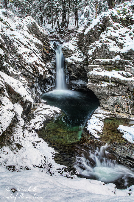
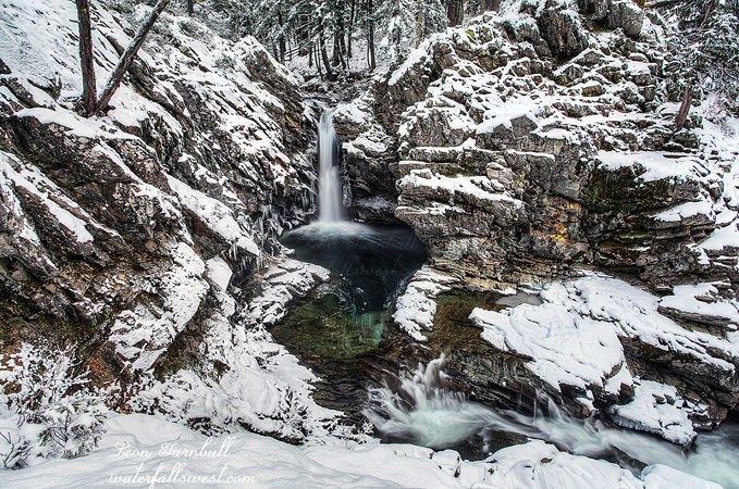
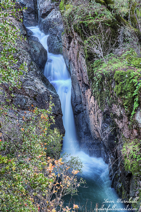
It is only about a quarter mile to the upper falls, but it is much brushier from this point. More brush. More oak. More ticks. I was not sure I would be able to make it at all. And yet … there was a trail to follow. Of course it was overgrown. I worked my way up to a side stream coming down from the left which I had to cross. It looked like there was a waterfall on this creek as well, but I did not stop to investigate. I crossed and continued up Clipper Creek. I made it. The upper falls was exactly where I predicted it would be. The slope was very steep so I could not get down to creek level and I had to photograph it from the side of the hill very carefully, hoping the ground would not give way and send me tumbling off the cliff (to my wife if she is reading this: I am kidding!). But it was a steep slope. The upper falls is only 22 ft. high. I expected around 40 or 50 ft. I am not sure but my gut tells me that it may continue around the corner but I could not get past the cliff to see it.

I was really hoping to photograph the lower falls afterwards, but it took a lot longer to get to the upper falls than I thought it would. By the time I got back down, the lower falls was in sun, so I just skipped it (I have photographed it before so it was no biggie). On the hike back out, I tried to take the higher contour that I took last time. Somehow, however, I got on another “trail”, this one leading on a contour much much higher. It seemed to just keep climbing higher and higher, trying to pass above the cliffs. I just kept following it because the trail was not hard to follow, but it was a tougher route. Finally it seemed to just come to a dead end, when I was almost back to Clarks Pool. It was fine all the way, and now it is going to end? What the hey? I decided to just go straight down hill to the main trail, hoping it was not too brushy to get down. I made it. It was definitely a crazy day, but I am sure happy I found the upper falls on Clipper Creek.

2 Comments

TORRENT MODE

With all this rain lately, I wanted to get out a few more times to enjoy the waterfalls (before they all dry up), so I headed out one evening to Traverse Creek Falls. It has been awhile since I have been to this one, but usually I go at least once a year.

I arrived at the trailhead late in the day and started the short hike into the falls. I knew it was going to be interesting at the very first small stream crossing, at which I had to make a significant effort to jump across. Hmmm, I never had to do that before. At this point already I knew the creek was in full torrent mode, higher than I have ever seen it before. Traverse Creek Falls has four modes: Dry, Single, Double, and Torrent Mode. I may need to add a fifth mode: Super Torrent.

Along the way, I came across some people carrying kayaks back up the trail. They were out for the afternoon enjoying themselves on the waterfall. When the creek is high like this, kayakers like going over this 30 ft. high waterfall – crazy people if you ask me, but they seemed to be very happy on the walk back (happy that they didn’t break anything, perhaps?). It is too bad I did not arrive 30 minutes or so earlier, or I could have seen and photographed them going over the falls.

The trail descends steeply to Traverse Creek, at which point you need to walk along the creek bed to the brink of the waterfall, then climb past the waterfall and descend on ropes to the bottom. With the creek very high, it was quite a challenge to walk along the creek bed. There were some spots that the water was practically right up against the bank, making it difficult to continue without getting wet feet. Again, I have never seen it like this before. Hmmm. Much higher and I would not have made it at all (and I suspect it was a lot higher last weekend). I climbed up past the waterfall and began the descent to the bottom. This part was also very tricky because the ground was wet and slick. There are ropes, but there is one spot that is especially difficult when the ground is wet, and instead of risking it, I got out my own rope to help me down this part (the rope that is there is not in the correct position for this section).

Once down at the bottom, I set up shop to photograph the falls, before it got too dark. The waterfall was absolutely incredible, and there was a lot of mist making it very difficult to get in close to the falls to photograph. I had to move back a bit and shoot more of a wide angle shot of the waterfall. This worked quite all right. There was a bit of fog above the falls, and on the drive back home the fog was extremely thick on the road. I kinda wished there was more fog down by the waterfall. Oh well. On the plus side, I did not see any garbage this time down by the falls. Usually, I have to truck out a big bag every year cuz certain idiots like to come here in the summer and leave their crap behind. I am very happy to see that this place is not a trash heap anymore.

2 Comments

FOGGY THUNDER

This is a shot taken just as the fog moved in over Canyon Creek Falls. Seconds later, you could not see a thing. I like this one much better than the last because of the atmosphere. What do you think?

The results from last weekend’s rain storm are in. Sacramento received 4.5 inches of rain, the foothills received 13.5 inches. The Folsom Lake reservoir rose from 37% to 53% capacity. Shasta and Oroville went from about 50 to 60 percent capacity. I actually expected the reservoirs to increase a lot more than this, but they are still increasing quickly. At our house in the Sacramento area, I measured 7 inches of rain at our house. It is interesting that I measured a lot more than the official numbers. The North Fork American River got up to 30,000 cubic feet per second on Sunday afternoon, incredible, and I wish I had gone out to see it on Sunday. Unfortunately, now we have one more storm tonight, and then things are going to dry out for at least a couple weeks. All the creeks will be back down to normal or below normal fairly soon.

No Comments