Jawbone

I slept in my vehicle in a campground in the area. If sleeping in my vehicle, I could sleep anywhere, but I prefer the safety of a campground. If I were out on some remote road, I would not get any sleep at all, as I would be worried about crazy people coming by, bears, cougars, sasquatches, that sort of thing. In a campground, I do not need to worry about anything, and thus I can sleep much easier, but after paying the $20 for the campsite, if I had known that all they had for services was a simple outhouse, then I think I would have braved the sasquatches. Geepers, $20 for a parking spot and an outhouse!

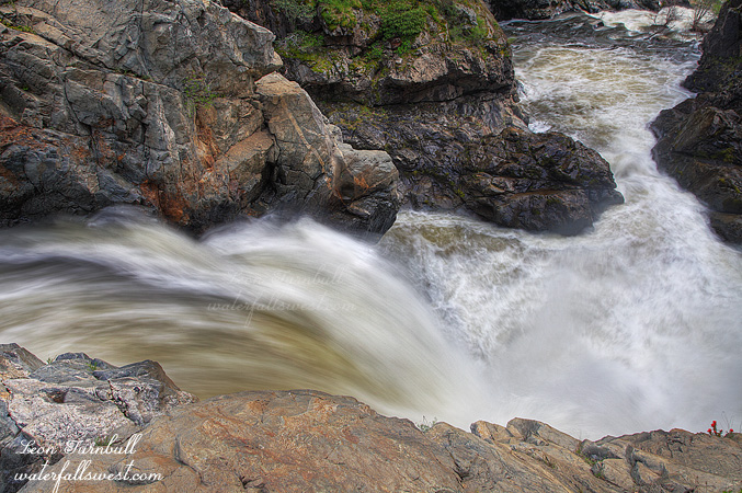
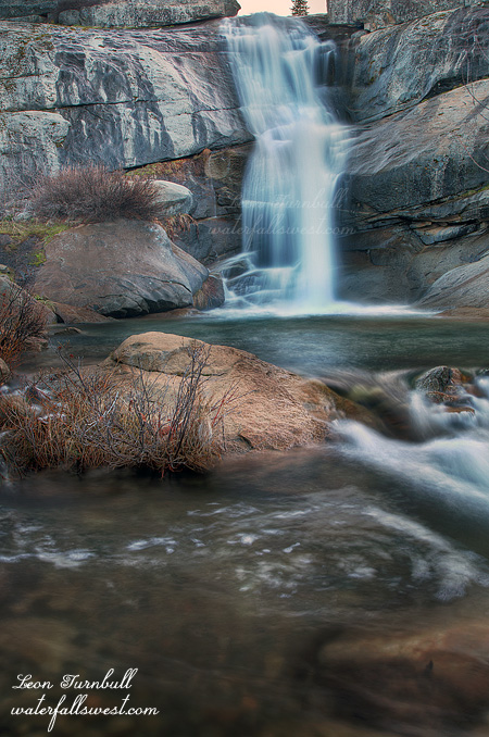
I got up super early in the morning and drove up Cherry Lake Road to my first destination. I was surprised to learn that all the Forest Roads up here were paved, I was definitely expecting a much rougher route to Jawbone Falls. That made the trip much faster and I arrived at Jawbone Falls a bit before sunrise. In Danielsson’s Northern California Waterfalls book, he describes this waterfall as “just a small cascade”. Yeah, I do not think so. He obviously did not even visit this waterfall before writing his guide book! Jawbone Falls is a large horsetail waterfall, 52 ft. high. This is not a “small cascade” in any shape or manner. It is not a huge one by any means, nor a spectacular waterfall, but it is certainly a good one. You do need to be here early in the spring though, as Jawbone Creek has a small drainage, so once the snow is all melted, it will reduce to a trickle.

Speaking of snow, I did find some on the road past here, as I continued past Jawbone Falls to attempt to find another waterfall. At about 5500 ft., I had to turn around as there was too much snow on the road to continue. Strike one. This was the beginning of my bad day after visiting Jawbone Falls (Jawbone made my day start out very nice, but it would not continue that way).

For my second hike of the day I was in a bit of a dilemma where to go. It was a sunny day but I was really hoping to get to a second waterfall location before the light got bad. There are other falls on Jawbone Creek but they all get early sun so I had no chance for them. There were some on Granite Creek that got later sun or one on Cherry Creek. I chose Cherry Creek because that was first on my way back down the road. Bad choice. The hike started out very well, following a nice trail along Cherry Creek canyon. Apparently I was not the only one who thought so because I was following some fresh tracks all the way down the trail. At first I thought they were bear tracks (I am not very good at identifying animal tracks!) and when I got down the trail further into a clearing I could see bear poop (fresh and old) everywhere. Okay then it must be a bear I was following. The poop was definitely bear but when I looked at my animal tracks app later I realized that the tracks resembled much more like a mountain lion! If I had realized that at first, would I have continued hiking down that trail??? Well I did not make it far down the trail anyway. The trail ended quicker then it should have as it was supposed to descend much further down the canyon, but it ended up being much too brushy and overgrown with manzanita. I was forced to go back. Strike two. I am not sure where the bears and cougars went either.

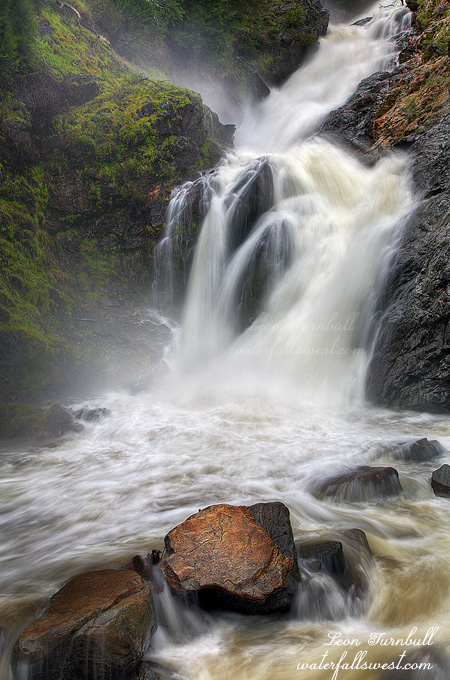
The sun was up by the time I got back to my car, disappointed that I did not get to a second waterfall location. I made my way down to Granite Creek and I was surprised to find a steep trail descending from the road down into the canyon. I had never seen photos of this waterfall so I figured it was impossible and much too steep to get to. Should I go down? I decided to try it. It was incredibly steep but not exactly dangerous though there were a few tricky sections for sure. The trail continued down so I did as well. There was a lot of poison oak and I ended up getting the itch quite bad from this hike, as well as a tick bite (though that was probably from a later hike). It got more cliffy as I got down closer to creek level, and as I was scrambling down my hat came off and tumbled down the hill just stopping at the edge of the cliff. Oh gee, how would I get that? I went down as close as I dared but was still too far away to reach it so I grabbed a long stick and reached out to drag the hat back up to me. Whew. After this I made it around the cliff and down to a long sliding cascade; the sun was already on the falls but I took a quick shot. I realized that I was still too far downstream from the actual waterfall so I made my way upstream through the poison oak and finally came to the waterfall which was a big one but really impossible to shoot as it was hidden up in the canyon and only the lowest and smallest drop could be viewed. Strike three (sort of) for Granite Creek. I took some shots and this is when I realized my 24-105 lens was not working. Why? I did not drop it or anything, it just stopped working. I sent it in for repair when I got home. $300 to fix. Ugh.

1 Comment

Paradise III

The third waterfall at this location is on the South Fork Tuolumne River just below the confluence with the Middle Fork. I walked down the road towards the falls from the bridge, rounded a corner, and came upon a huge landslide blocking the road. Giant boulders had crashed down onto the road. If the landslide was not there it would have been easy to continue around in front of the falls to get a top notch vantage point of the waterfall. As it was, however, I could only view the falls from the brink, it was too dangerous to try to get around the landslide. Could it have been done? Perhaps but in my view it is the same thing as wading into a raging river at the top of a 400 ft high waterfall. You are just tempting fate. Stupidity kills and we all know about the recent deaths in the last couple years at California waterfalls. This is a similar thing. What if the rocks had given way while trying to cross the slide? Off the cliff and into the river would I go. Not fun. Anyway, I do hope the forest service is able to clean up this slide. It looks like it will be a lot of work to do so.

No Comments

Paradise Part II

As you make your way down to the confluence of the South and Middle Forks Tuolumne River, the first waterfall you encounter is this one on the South Fork. It is an utterly spectacular 25 ft. plunge. From the bridge you can see both of these falls (the other one being on the Middle Fork), though not in a single camera view, and the mist from them both is great, making them both very difficult to photograph. I took this photo from a bit up the road (away from the Middle Fork), where the mist was much less.

I am naming this waterfall “Lower Rainbow Pool Falls” due to its close proximity to Rainbow Pool Falls, just upstream on the South Fork. When I came down here on Friday evening, there was no one at Rainbow Pools (and obviously no one at the lower falls here either). But when I went back on Saturday evening, there was a ton of people at the Rainbow Pools. Geepers. Yet, not very likely was there anyone down at these falls on Saturday either. Perhaps once this is up on my site, this location will get more traffic now. The Lower Rainbow Pool Falls is almost twice as high as the upper falls, and about 100 times more spectacular.

No Comments

Paradise Found

What do you think folks, does this place really exist? Three spectacular waterfalls, all within a couple hundred feet of each other? All unmarked and unnamed? (until now). Within a few miles of one of the most popular parks in the country? Very easy to get to, yet a virtually unknown location? Within minutes walking distance from an extremely popular picnic area and another (much smaller) but very well known waterfall? What do you think, not possible? Oh, and did I mention that one of the waterfalls was an incredible 182 ft. high?

Oh yes, it is possible. The location is Rainbow Pools, just outside of Yosemite National Park. Most people familiar with California waterfalls and with the Yosemite area have likely heard of Rainbow Pools, and many people have been there as it is very popular. But 99.99 percent of the people who go there do not know about these other three waterfalls, just a very short distance away. Indeed, I did not until recently when the kayaking community alerted me to this location. But even so, I had no idea what exactly I would find there.

There is a road leading from Rainbow Pools downriver, and I was thinking I would be able to drive down it. But the road was closed due to an apparent landslide. It was getting late in the day, but I still had plenty of time and it was only a half mile walk. The road follows the raging South Fork Tuolumne River downstream, alongst plenty of small rapids and cascades, and at least one other significant cascade (which could not easily be seen due to the steep cliffs). I saw no landslide as I made my way down the road, but I am glad the road was closed, because I would not have wanted to drive down it. It is very steep and very narrow. I hate steep, narrow roads.

In fairly short order, I came to the confluence of the South and Middle Forks of the Tuolumne River, and there I was treated to paradise. Two waterfalls coming together at the confluence, a 25 footer on the South Fork and a whopping 182 footer on the Middle Fork. A bridge crossed over the middle fork and the road continues downstream. There was so much mist from the falls it was very difficult to photograph this monster, but I found a semi dry spot in the middle of the bridge, and took a few shots; compositions were extremely limited because of the mist, but it sure was a beauty, and most definitely the best waterfall I saw on the weekend. How could no one know about this place or this waterfall? Just downstream, I could see a horizon line and I knew there was another waterfall there. I continued down the road, and as I turned the corner, I found the landslide, at the top of the third waterfall. Humungous rocks had fallen on the road, and it looked to be very dangerous to continue past them. I was only able to view this third waterfall (51 ft. high) from the side and top of it, but it was certainly another spectacular plunge, and if the landslide was not there you could get around right in front of it very easily. Wow, it was an amazing evening, and a remarkable location. It was getting dark as I reluctantly made my way back up the hill to my car. Very satisfied.

3 Comments

Diana

I had big plans all made this weekend, but sometimes plan do not work out as expected. I wanted to go to Hetch Hetchy and stay overnight in the backpacker’s parking area, then hike to Rancheria Falls first thing in the morning in order to get there with good lighting conditions for photography. It was a great plan. All I needed was a permit. But the bloody darn Yosemite rangers would not give me one. According to them, I was not a backpacker, I was just a day hiker. What? Sometimes it sucks to tell the truth, but I really had no idea this would be any sort of issue for them. It was a perfectly reasonable plan, and I am sure I read that people have done this sort of thing before at Hetch Hetchy. With the park not opening until well after sunrise and closing well before sunset it is absolutely impossible to do any good photography in this area of the park unless you stay overnight. Why would they not give me a permit? I don’t understand, and it really irked me.

Anyway, this totally threw a wrench into my entire weekend plan, and it put a huge damper on an already bad  day. I did see four waterfalls on Saturday. The first one I saw was really nice but all the others were not so great, and the light was really bad for them, and some other waterfalls I was trying to see did not pan out either, and I got a tick bite, and my camera lens broke (for an unknown reason), and I got poison oak, and I lost my pack rain cover, and I almost lost my hat off a cliff. None of all those other things would have bothered me much, however, if the Hetch Hetchy plan had come to fruition.

Friday was different though. Friday was a great day, and I saw four waterfalls on that day as well, and they were all great ones. The first one was Diana Falls, pictured here, just a small 21 ft. high falls, and very easy to get to, but I had never been to this one before. When you are going to Yosemite, you don’t stop off at small baby waterfalls along the way usually, and that is why I had never been here before. But this time, I was planning to spend a lot of time out of the park before going into it at the end of the day on Saturday, so Diana Falls was first on my list.

It is a long drive down there from Sacramento, and I left work early. Still traffic was bad leaving the city. When I finally arrived at the trailhead, I saw 3 other cars there. Not good, as I was hoping to have the falls all to myself, but all the others I met on the hike in, so I was alone once I got to the falls. It is a bit of a steep descent down to the waterfall, slippery, and laced with poison oak (but this is not where I picked up the oak, I am certain). Those rocks you see on the right side were incredibly slippery. I scrambled up there close to the falls, and I had to be extremely careful or I would have slipped right into the creek. That would have been quite bad. Anyway, it is a very pretty little area and waterfall. I took my time here taking photos, then afterwards, hurried back to the car, to get in one more location before dark, which was triple decker awesomeness. Stay tuned for that.

5 Comments