It is coming. Maybe. I hope. Perhaps. I’m talking about snow of course. We are still waiting for winter to start here in northern California. The last report I heard is that it is on its way. Mid January things will start to look up. I hope.
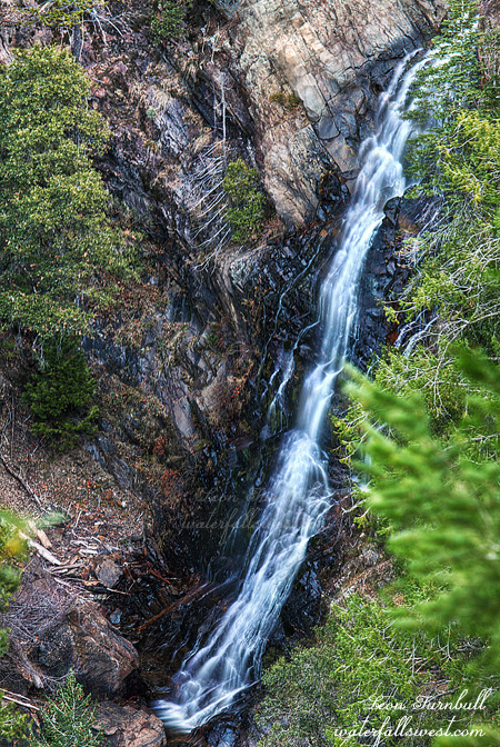
In the meantime, I ventured out to Foresthill looking for a new waterfall on Big Mosquito Creek. With an ominous name like this, I don’t think I would want to come here in the summer. I did not think it would be flowing greatly, but it was more of a scouting trip to return to in the spring (before mosquito season, hopefully). I found the waterfall pretty easily, the viewpoint is just off the main road. Getting down to it is another matter entirely. I did not try this time due to sore ankle and lack of water flow, but I think it is possible, and when I return back in the spring I will definitely give it a go. Another reason I must return is that I am not very happy with this photo. I did not get it in good focus for some reason. Was my I.S. switched on unawares? I did not think so. Ugh. Well, if we do get some snow, then this creek should have great flow in the spring, and the waterfall will be rockin.
Waterfalls, actually. Yes, there is almost certainly a second, much larger waterfall on this same creek downstream. Unfortunately, I think it might not be possible to get down to it. It is about 2 or 3 miles downstream from the upper falls, and after taking a gander at this upper falls, I ventured downstream seeing how close I could get to it. With my ankle still being sore, I did not really want to go too far. Indeed, I went further than I should have, but the going was actually pretty easy and the forest was pretty open, as I think there was a fire that went through here many many years ago. But further down it starts to get very cliffy and that is where I turned around, still a good two miles from the waterfall. From where I turned around, it would have still been possible to continue. But for how long, I do not know. On the way back up, I came to a strange open, flat area. It seemed there was a lot of old bear poop scattered throughout the area, and bear trails going off in different directions. Was this where all the bears in the area hung out? Or slept? Then I heard a strange sound, like a horse. (but obviously, it was not a horse). I do not know what it was, if anything. Maybe a bird. But maybe it was a bear turning over in its sleep. I did not see anything. But I sure did not want to wake up a sleeping bear, so I scooted back up the hill as fast as my sore ankle could take me.
Posted in Northern Sierra, Waterfalls by leapin26: January 8, 2012
The weather is all twisted. Winter is supposedly well under way but definitely not for us here in northern CA. After a decent November we had nuthin in December, one of the driest Decembers ever. Initial reports indicated the wet weather would begin in January but now I’m still not seeing too much of anything in the long range forecasts, except for an occasional shower or two. We are probably looking at more dry weather through mid January. Of course we need the rain and snow for more than just the waterfalls. It is our lifeblood in California.
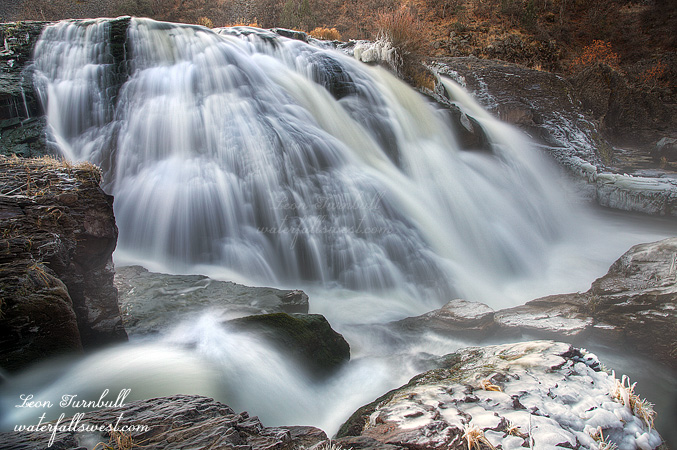
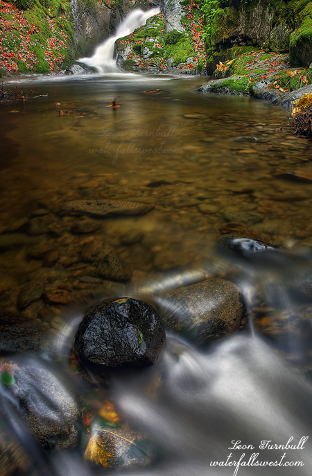
Well, not to be outdone by the dry weather I still wanted to go waterfallin on Christmas Eve on the way up north to visit family. The original plan was to hit Feather Falls, but I just happened to see on dreamflows that PG&E was releasing huge amounts of water in the Pit River and that meant that Pit River Falls would be flowing. Indeed it should be utterly spectacular. Even though it is a four hour drive from my house it would be well worth it and I was going north for Christmas anyway. So up I got at 2:30am and started driving north. I arrived at the Pit River overlook at 7am. Pit River Falls was NOT utterly spectacular. What the hey? This was all twisted, it made no sense. At 5am the gage above Pit 1 Powerhouse was at above 20,000 cubic ft per second. That is mega water flow! But now at 7am it looked to be only at 500 or 600 cfs. What happened? Did they only bring the water level up for a short few minutes? Or was it some sort of error in the gage reading? I do not know. Neither one makes much sense. Well even at 500 cfs the river still has good flow, albeit not spectacular, and I had never been down to the bottom before (not to mention the very long drive out there), so I decided to continue the plan of hiking down to the falls.
If there was an actual well defined trail to the bottom then it would have been easy. There is no trail. There is a path that people have gone down before, but it is very overgrown, there are a lot of branches and twigs you need to walk over, the ground is very rocky and crumbly, and the slope is steep. About 2/3 of the way down I slipped on that crumbly slope and fell, severely twisting my ankle. I heard a pop sound as I fell. Oh oh. It was definitely not broken but it was not good. What should I do? I sat down and recovered myself for five minutes then I decided it was not (and would not be) a show stopper. I continued down to the falls, slowly and gingerly. It was not that bad but I was limping and not putting much weight on the ankle. Coming back up the mountain afterwards was harder but I still made it without too much difficulty. The worst part was the next day, when I was in quite a lot more pain and hobbling around the house worse than my mother in law’s 16 year old cat.
But I made it down successfully to Pit River Falls. The waterfall was nice and with less flow it was easy to climb around on the rocks beside the falls. There were a lot of photo opportunities and I took plenty of photos. Without knowing what the heck was going on with the gage reading I was a bit worried about this, wondering how safe it was down there, and what would happen if they suddenly released a truckload of water over the falls. I watched the river carefully always making sure I had a quick escape route. All in all, it was an enjoyable morning despite the pain, and if you are wondering how my ankle is now, it recovered quite well enough to get back out on the trails on Tuesday.
Posted in Northern CA, Waterfalls by leapin26: December 28, 2011
Emerald Pools Take Three.
This weekend they were still releasing water from Lake Spaulding into the South Yuba River so I took one last trip up to see the Emerald Pools on Sunday afternoon after church. (and as it turned out, on Monday morning the faucet was turned off; I got to see it on the last day the river was still running).
I wanted to get down to the lower Emerald Pools on the north side of the river this time and try to get a decent shot of the falls from there.
Along the way I stopped off at the Upper Emerald Pools to attempt to locate my sunglasses where I think I must have dropped them. Could not find them. Bummer.
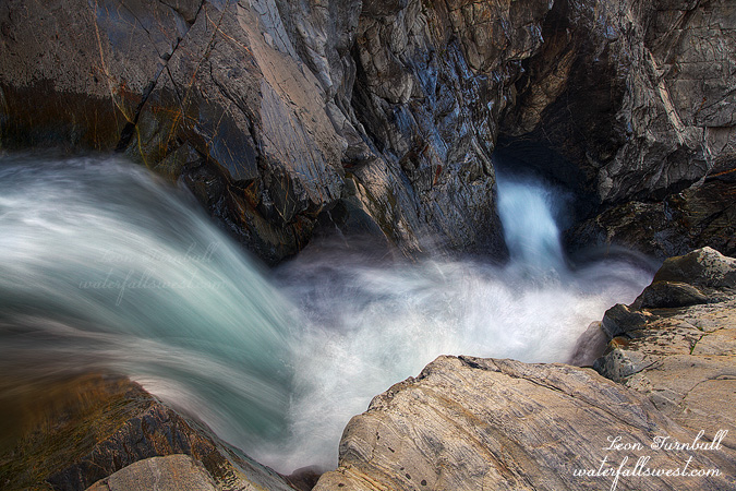
Continuing on, I made it down to the brink of the lower falls in short order. My goal was to photograph the lower tier of the falls from the north side cliffs (which I did) but what I found much more intriguing was the view looking down the falls from the brink of the upper tier. Incredibly cool. It was actually easy to get right down beside the falls. I got over as close to the edge as I dared (which was pretty close), sat down on the rock, and setup my tripod. The biggest thing I was worried about was dropping my tripod/camera over the brink, but I kept a very tight rein on them. It was quite an exciting location. After this I went along the cliffs to get a good view of the lower tier, then took a shortcut back to my car on Bowman Rd., making it back home by dinner time. It was a great Sunday afternoon.
Posted in Northern Sierra, Waterfalls by leapin26: December 19, 2011
I took a lot longer photographing the lunar eclipse than I anticipated or wanted. My plan was to leave by 6:30AM and drive on up I-80 right afterwards to Yuba Gap, and back to the Emerald Pools. I ended up leaving 30 minutes later than that, and that was after stopping at Starbucks to refuel. I thought about just going back to bed, but according to my calculations, the sun would not be hitting the Emerald Pools until 9AM or 9:30AM, and so I figured that would still give me plenty of time to get there. And it did.
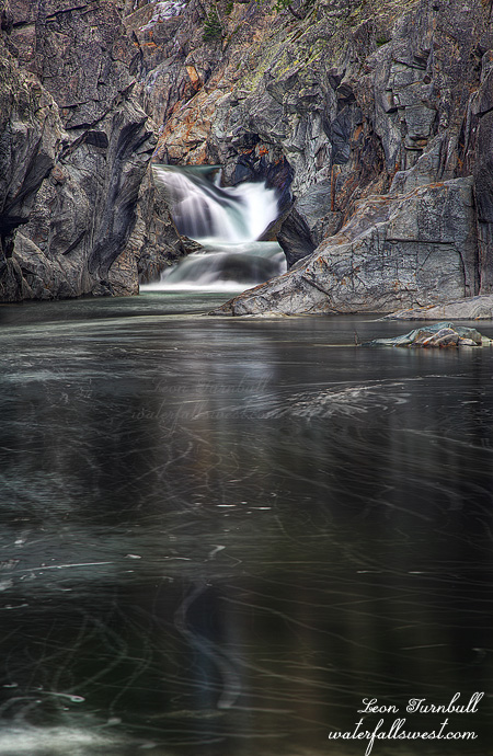
If you remember my last photo of Emerald Pools, you will recall I could not in any way get down to the bottom to photograph the waterfall from below. My intent this time was to approach the falls from the other side of the river. It looked quite steep from the other side, but do-able. As it turned out, it was actually fairly easy to get down, though it did take longer than I expected. I ended up following what appeared to be a mountain biking trail in recluse, abandoned to the elements, or at least to only the occasional summer hiker. It followed the river downstream for awhile, then turned away from it, and seemed to end along Bowman Rd. At that point I went cross country, making my way back to the river, and then down the steep hillside to the river. I ended up exactly where I wanted to, at the bottom of the Emerald Pools, with a great view of the two tiered waterfall that I could not get from the other side. I got two super nice photos of this place, and I could not decide which one I liked better. I’ll probably share the other one later, but this one is more of a closeup of the falls. It perhaps looks a bit bigger than it really is, but it is precisely 20 ft. high, the upper tier 15 ft, and the lower 5 ft.
After shooting Emerald Pools, I went down river a ways more and found a really interesting 30 ft. high waterfall, but with too much sun, and no way to get in position to photograph the waterfall in any respect, due to the cliffy terrain. I know there are even more waterfalls on the river below this one, but the gorge gets crazy steep in very short order. Only kayakers can get down there. Or maybe not.
Posted in Northern Sierra, Waterfalls by leapin26: December 11, 2011
I love studying topo maps to try to find new waterfalls. I suspected there might be other waterfalls on Brandy Creek and my goal on Thanksgiving Day was to find them.
I cut down off the main trail and descended the steep terrain to creek level to the spot on my map where I figured there should be a waterfall. Nothing. But not giving up yet, I then traversed downstream. I found something. Two somethings. Unfortunately though, they were small somethings. The upper and prettier something shown here is about 11 ft high. I could not get any closer to the falls than this as that pool is quite deep. The lower falls is about 15 ft high though from certain angles above it looks much higher. It was very cliffy and too difficult to get down to it. If it was bigger I would have attempted it but instead I just took photos of the upper and more photogenic falls. I was bummed these falls were not bigger as I do not think they warrant inclusion on my website. Oh well. I ran out of time to explore as I needed to get to Redding.
On the way back down I passed another group of hikers and then saw more as I drove back down the road. I was surprised. I did not think I’d see anyone out and about on this day. I guess they had the same idea as I did to get a good hike in before eating their big meals.
Posted in Northern CA, Redding, Waterfalls by leapin26: December 6, 2011
