Occupy Waterfall

Now that is what I am talking about.

Well it was not Plan A. And it was not Plan B. But Plan C worked out pretty fine. I wanted to head on over to the Eastern Sierra on Saturday. The big waterfall at June Lake is flowing right now, and I had hoped to get up to the base of it. However, due to the most recent snow storm, the road over Monitor Pass is now closed. With luck, it will re-open this week and I can try again next weekend, but there is a good chance it will now be closed for the rest of the winter. Plan B was to head over to the Yosemite area, where I know of certain waterfalls that also are flowing well right now. But the weather forecast was calling for a sunny day on Saturday, and I did not want to drive all the way out there, and not be able to get good photos of them. I really need a cloudy day for that trip. As it turned out, it was a cloudy day on Saturday! What the hey? I could have done Plan B after all. Darn weather forecasters.

Plan C was to do an easy hike back up to Alder Creek Falls near Kyburz, hoping to get down to the bottom of it. It was a very cold morning, and there was some snow on the ground, though not too much. I got to the top of the waterfall easily enough. But it is very steep on the one side of the creek, and not possible to get down to the base of the falls. I was able to cross the creek, however, at the top of the waterfall, and work my way down on the other side. If the creek was flowing any higher, I would not have been able to do this. It was a bit sketchy in a couple places as it was. Nonetheless, I made it down, and I was happy to do so. This would be a fantastic place to be in the spring, but crossing the creek at the top of the falls will not be a possibility in any way, shape, or form. Hmmm, what to do, what to do.

No Comments

Waterfall Color!

Fall Color and Waterfalls. That is what I like. That is what I want. The only trouble is, gorgeous fall color around waterfalls is hard to come by in California. Usually by this time of year, most waterfalls are dry or just a trickle, and I do not know of too many waterfalls that have fall color around them anyway.

I had heard from certain unnamed sources that the color was at peak on the west side of the Sierra Nevada, so I called my friend Rob and off we went at 5:30AM to Hope Valley. It is very late in theĀ  year for Autumn colors here. Rob had figured he had already missed it by a few weeks. But not so. Indeed, we picked the perfect day to head up into the Sierra. Hope Valley was definitely at peak for color. Gorgeous Aspens in bright yellow and orange. It was perhaps the best I have ever seen it here.

I dropped Rob off at Sorensen’s Resort, as he did not want to shoot the waterfall. But I did. I was not sure if there was actually any color around this waterfall and along the river here, but when I arrived I could see that there was some. I have a lot of troubles shooting colorful Aspen trees if there is not any water. Finding a good, stellar composition of Aspen trees is extremely difficult (for me, anyway). But if there is water, I am good to go. Water is my thing. Colorful trees abounded along the West Fork Carson River, and with the recent storm of a couple weeks ago, we had a bonus. The waterfall was actually flowing. Sweetness! I made my way down to the base of the falls, hopping along rocks until I got into the middle of the river, and I found yellow Aspen goodness looking down on me from the top of the falls. I had my colorful waterfall shot after all.

The sun came up quickly but after shooting the waterfall I took a few more shots of the river further downstream, then I went back to find Rob. He was waiting patiently at the Resort for me, going stir crazy from the tempting smell of breakfast cooking. I told him we had to go on one quick hike before breakfast, which we did, though not finding anything worth mentioning on that hike, which meant I had to pay for breakfast since I dragged him on that semi-useless hike. But I was glad to pay. The food was good, though only lukewarm and the service was not so good.

Sorensens Resort has a lot of photo prints on display, many from a photographer named Tony Rowell, son of the late great Galen Rowell. The lady at the resort said his prints sell very well there, but I just kind of wonder about that. I was not too impressed with a lot of them, which were taken with boring cloudless skies. What is so great about that, I wonder? Is he just selling so many prints because of his name? And why do the ones that are so blah looking sell the best? Rob said that when he was at Elizabeth Carmel’s gallery in Truckee, and talking to one of the workers there, he was told the best selling of her prints he thought were just, again, blah and boring. Are we missing something here, Rob and I wondered? Why did the lady at Sorensens Resort look at us so strangely when we told her we were done photographing for the day as the light was now bad? Should we be photographing during the middle of the day when the light is so flat and harsh? Is that what people want to buy? Hmmm ….

Ah well, we sure did have a gorgeous and fantastic morning up at Hope Valley.

4 Comments

Sheep Creek

On the way up to Rossland, we stopped off at Northport, WA. I’ve been meaning to try to get to this certain waterfall on Sheep Creek. It is on private property and there is a powerhouse right beside it, but the owner allows people to come here. I previously was not sure exactly how to get here, but Gregory Plumb (Waterfall Lovers Guide to the Pacific Northwest) provided me with fresh off the press directions and I was eager to try them out. His directions were pretty good, but I did miss the turnoff from the highway, as there is no indication you are on the right road (except for no trespassing signs). But I knew it was ok to trespass here from others who have told me. There was no one around anyway.

It is a fairly easy descent down to the base of the falls, and the whole family made the journey. We had an enjoyable time down at the falls, playing in the water. Jadon of course had to try out his new rain boots, and went splashing across the creek, but it was deeper than he thought, however. I measured the waterfall as being 149 ft. high, but it sure did not seem that high. It seemed more like 80 ft. or so to my wife and I both, but I will stick with the official measurement of 149 ft.

This was one of three waterfalls I went to on my vacation. I had planned to go to more. I even went on additional hikes. In Rossland, I was really hoping to find one particular waterfall, but unfortunately, I did not have good directions, or good hiking maps, and I did not know exactly where it was, though I had a vague idea. By looking at the map I did have, I estimated the hike down to it would be 12 miles round trip, 14 tops. That is well within my hiking range, so I decided to give it a go. Well, it was not 12 miles. It turned out to be 20 miles, and the worst part was the descent. You need to climb up a mountain, and then down the other side all the way down to the bottom. I had no idea before I started as to the topography of the area, but the trail just kept going down, and down, and down. By the time I got to the bottom, I had descended 2800 ft. And there was no waterfall in sight. By this time, I knew I was well past my hiking limit. I was not even sure I could get back up the mountain. I should never have gone down in the first place, but I just kept thinking the waterfall was not too much farther, and how much farther could I descend anyway? I had to turn around before I got to the waterfall, though I think now that I did not really need to go too much farther to get to it, but as I said, I was well past my hiking limit, and I could not have gone any further. 2800 ft. is definitely a long way up. I took it slowly, one step at a time, and eventually I made it. I did not really have too much trouble on the ascent, the worst part were the blisters on my feet, making it very painful to walk, especially the last few miles. I estimated the total elevation gain for me on this 20 mile hike (with all the ups and downs) was about 4300 ft, making it one of the worst hikes I have ever done (for elevation gain). But the good part was the entire hike was at low elevation, so this is why I was able to do it. On one of my recent hikes at Lake Tahoe, I had a lot more difficulty even though the distance and elevation gain was much less, and that was due to the high elevation of that hike. Anyway, as it was, I barely made it back to Rossland by dinner time. Fortunately, my mom had her famous lasagna in the oven and ready to eat when I got back. Thanks mom. That sure helped me recover some energy, but I was essentially out of commission for a couple days after this hike, thanks to blisters and bruises on my feet. I definitely overdid it this time.

2 Comments

Velma

The weather has turned finally. The summer heat is gone. I think Fall is my favorite time of year as far as hiking is concerned. Unfortunately, the waterfalls do not agree, as it is the worst time of year to see waterfalls. Nonetheless, Tahoe was beckoning to me this weekend with the cooler weather.

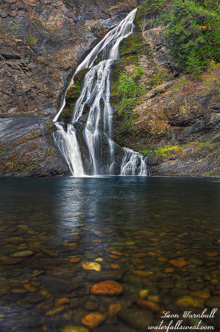
I drove up to Lake Tahoe in the afternoon, arriving at the Eagle Falls parking area about 1:30pm. There was one parking space left in the parking area. I took this as a good sign. God must have wanted me to go on this hike. I had my doubts. My hiking plan was ambitious and I was sure the waterfalls would not be flowing very well. I took a quick look at Lower Eagle Falls, and my suspicions were confirmed. Eagle Falls was barely trickling.

There were a ton of people on the trail. I thought that once I got above Eagle Lake, the hiking crowd would dissipate to nothing, but it seemed there was a constant stream of people descending the mountain on this Saturday afternoon.

I hate hate hate this trail. It is so incredibly rocky, which makes it very tough on the feet hiking, and so very hard. Descending the trail later, I am constantly telling myself how much I hate this trail. With perhaps one or two bad words thrown in as I come close to breaking my ankles mis-stepping on the rocky terrain. Every time I hike this trail I say the same thing. Yet I still hike this trail at least once a year. Why do I continue to put myself through such agony?

I suppose because it is so awesomely beautiful up in the Desolation Wilderness.

In addition to the rocky-ness, it is a very tough climb up into the mountains. From 6600 ft., you climb up to 8200 ft., then continue hiking at this high elevation, which is very difficult when you wake up in the morning at only 200 ft. elevation. My hike on this day was 12 miles round trip, and I was completely spent by the end of it. Even a small up hill was just killing my legs. Fortunately, it was all downhill on the return trip.

My plan was to go to Lower Velma Lake, which is a lake that is off the beaten trail. There is indeed no official trail to this lake. Once you get up to Upper Velma Lake, you need to get off the trail and essentially follow the outlet stream from the upper to the lower lake. It is actually fairly easy going and there is a path which others have taken. Once at Lower Velma Lake, the going gets a bit rough and quite brushy as you work your way around to the outlet stream at the end of the lake. It involved scaling along a cliff, and crashing through forest and brush, but there was a bit of a path to follow, and I made it to the waterfall at the end of the lake easily enough.

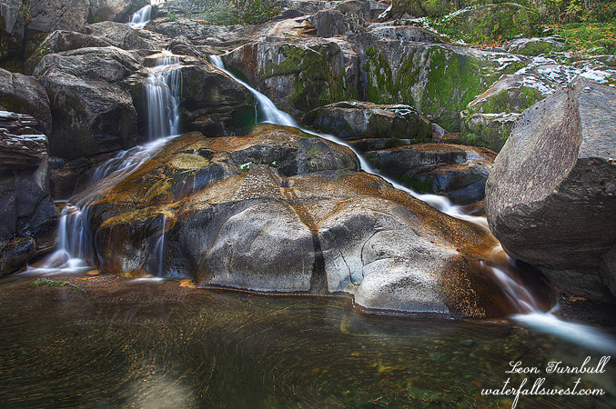
Lower Velma Lake Falls is a much smaller waterfall than I hoped to find, only 14 ft. high. I found it initially by studying Google Earth, and I must say I was hoping it would be a bit bigger. With theĀ  flow on the low side, it is certainly a pretty little thing, but it would be much nicer with higher flows in early summer. I will probably not ever come back here though, it is just too much effort. I did like the swirlies in the water foreground, though, and I purposely made a longer exposure in order to emphasize them.

I was not long here though, as I had run out of time. I started my hike a bit later than I wanted, and it took a lot longer to hike up than anticipated. 2.5 hours up to the falls, and it would take 2.5 hours back down. I left the waterfall at 5PM, and with sundown before 7pm, you do the math. It was dark by the time I got back to Eagle Lake, and from there down to the highway, it was complete darkness. Initially, I had hoped to get back down to shoot sunset at either Eagle Lake or Eagle Falls. When I started out, there were no clouds over Lake Tahoe. So no big deal I figured if I don’t make it back down in time. But as I left Lower Velma Lake at 5PM, I could see Lake Tahoe, and I could see potentially nice sunset clouds forming. Dang. Sure enough, as I descended the mountain, those clouds put out some pretty sweet color. But it was too late for me to get there. Oh well. Eagle Falls was just trickling anyway, I told myself. It would not be a very good shot. Yeah, right.

2 Comments

Brandy, please.

I needed to get out this weekend. And I did.

My wife Tara was being promoted to second degree black belt in Kenpo Karate. She had asked me a long time ago to go up there to see the promotion. At the time I said yes, of course I would. But things got a little too crazy at work, and with a deadline approaching this Tuesday, I was pretty sure I would be working all weekend. Well, as of Friday morning, I figured I was caught up enough at work that I would not have to stay home and work all weekend, so I hopped in the car and boogied on up I-5 to Red Bluff Friday evening. Actually, I did end up working a bit on the weekend, but fortunately I could do that up in Red Bluff.

One thing I wanted to do while up north was take my son Jadon out hiking in the Whiskeytown area. I decided on Brandy Creek Falls, which Jadon had not been to before. I woke him up super early. Knowing that the light hits the falls pretty early, I wanted to be up at the waterfall by sunrise or shortly afterward. Well, the hike is a tough one, even though it is only about a mile and a half. Jadon was struggling, and I was worried we would be too late to the waterfall, but as it turned out, we arrived in plenty of time. The creek was flowing a bit less than I was hoping for, but it is about normal for this time of year. I took my photos while Jadon waited around semi-impatiently. On this particular image, I was having Jadon hold back some branches in the way, while I set up my tripod at the edge of the creek. Well, the rocks were wet and slippery, and indeed I did slip, my feet sliding into the creek and into my tripod. My first instinct, of course, was a good one. Save the camera at all costs. And I did save it. My feet got a bit wet, but that was all. I tried to make it into a teachable lesson for Jadon. Be careful around creeks and waterfalls! It can be very treacherous. I’m not sure how well he got the point, however, as he scampered back along the rocks, splashing through the creek to cross to the other side. Sigh.

4 Comments