Trail Blazer

Well we were supposed to get snow Friday night in the Sacramento area. I was expecting (not really) to wake up to a winter wonderland Saturday morning in Folsom. It would have been nice. But I did anticipate that Auburn would have a nice dumping Friday night. It did snow there on Friday morning I guess, but they were supposed to get more Friday night and that did not happen. When I arrived in Auburn first thing Saturday morning, all the snow was gone. I was hoping to get some snowy shots down at the Confluence, of the No Hands Bridge along the river, and I was also planning to go to the Black Hole of Calcutta Falls, hoping for some snow there as well. With no snow, the No Hands Bridge was out of the question. I considered going to the waterfall, but I already have a good shot of that one, so I nixed that idea. Time to implement Plan B.

Plan B turned out to be an ideal choice. And a fantastic adventurous one as well. My idea was to try to get to a waterfall on Clipper Creek, about 1.5 miles upriver from the Confluence. I did not really think I would be able to make it. I was certain there was no trail, that it would be too brushy, too tick infested, too poison oak infested, and worst of all, much too cliffy to get up that far. But hey, I am always up for an adventure and a mad scramble through brush and poison oak. There certainly was a lot of poison oak. I knew that, and I anticipated that, but that was the least of my worries, so I thought. When I tried this route last year, I got turned back by ticks. In the spring, this whole area is infested with the buggers. I have said it many times, I can handle the poison oak, but I cannot handle the ticks. But I figured this was a good time to go, with the recent cold weather, perhaps they would not be lurking about. And I was right again about this. I only had to pluck a single one of the little beasts off me today.

As for the rest of it, I was pretty much completely wrong. And that made me ecstatic. What I mean is that there was indeed a trail to follow. And it went from the Confluence all the way up to Clipper Creek and beyond (likely, all the way to Lake Clementine). It was an old trail, and certainly overgrown, but hey, it was a trail. No bushwhacking through thick brush and along steep cliffs. That was my next worry, as I knew there were steep cliffs on this side of the river. But the trail seemed to bypass these cliffy sections quite perfectly. There were no dangerous sections along the trail at all. It was certainly not an easy hike, that is for sure. But it was definitely an adventurous one, and one that I will do again for certain.

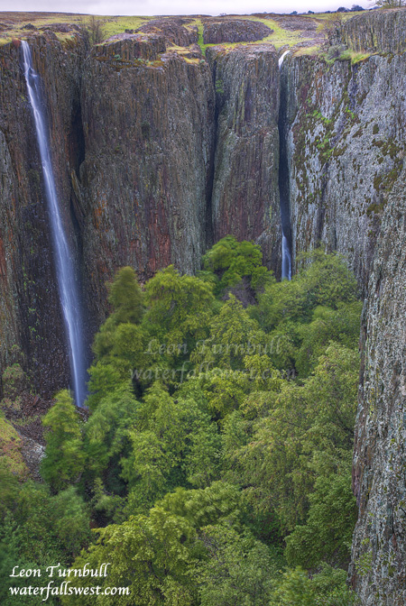
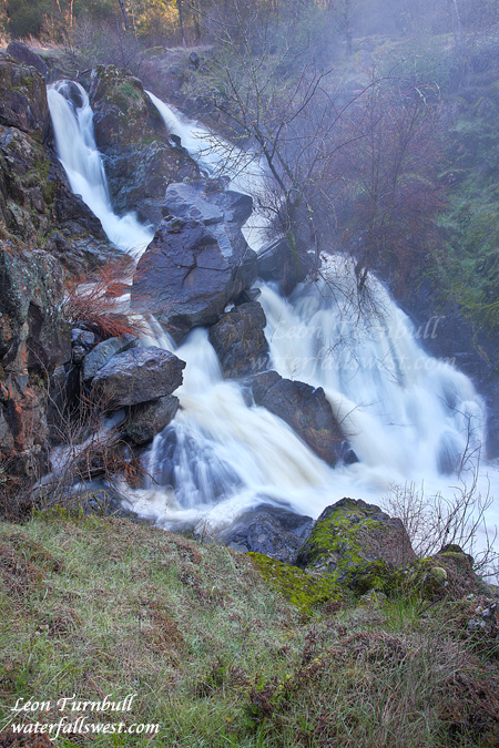
As for the waterfall, well it was a dandy. It was smaller than I expected. The topo maps seem to indicate a waterfall in the neighborhood of 60 ft. or so, and I measured this one to be 27 ft. high. I was a bit surprised at that, as it seemed quite a bit bigger than that, but hey, 27 ft. is not shabby, and it definitely was worth the effort to get to this one. As Arnold says, I’ll be back.

http://www.waterfallswest.com/waterfall.php?id=628

No Comments

Crevice

We have not had much rain here in northern CA lately. January and the first part of February was quite dry. This was not good news as we really need more rain this winter, and it meant the waterfalls had pretty much dried out. But last week we got a big dump, and that got the waterfalls flowing again (for now). After the big storm I decided to head back up to Oroville and Table Mountain. There are still a few waterfalls up there that I have not been to believe it or not, and I wanted to get some of them off the bucket list. I only had a few hours, so I chose three to visit: Coon, Ranch, and Crevice Falls; all of them are fairly close together and can be reached on an easy 5 mile round trip jaunt across Table Mountain.

I arrived at the trailhead (though there is of course no trail), and it was still dark, so I got out my head lamp and headed across the field, watching out of course for the many cow pies along the way. In addition to the cow pies, I had to watch out for the many puddles as well from the recent rain. I was trying to look down at my feet for the cow pies, and at the same time look up for the upcoming puddles. It was Saturday morning, and the rain was “just” beginning to stop, in fact, it was still lightly raining when I headed out. After scaring away some cows (I am sure they don’t see too many people walking out in the night with headlamps on them), I arrived at Coon Falls. It was still well before sunrise. Rather than wait for the light, I decided to head on to Ranch and Crevice and come back to this one. Coon was flowing fairly decent (it does not have very much drainage), so that was a good sign. When I got to the creek crossing for Ranch Falls, I had trouble crossing it. There was a lot of water flowing in that creek. I continued on to Crevice Falls and shortly reached the viewpoint. It is an interesting viewpoint to reach. I had been here last year with my friend Rob when Crevice Falls was dry. We found a somewhat scary viewpoint where you need to cross over a bit of a “crevice” (not the “crevice” that the waterfall is on), and you are somewhat unsure if the ground is going to be steady because there is a humongous dropoff just to the left of this “crevice”. But in fact the footing is secure, and after crossing it, you walk out on this ledge with incredible dropoffs to either side of you. At the end of it, just stand in amazement.

I was amazed for sure. Crevice Falls drops through a huge crack in the cliffs of Table Mountain, mostly hidden from view. You cannot see the entire waterfall, only the top part of it and some of the bottom. I looked around for other viewpoints of this waterfall, but this was the only good view of it. I should say, actually, that there was another ledge that could have provided a better view. But to get onto it, I would have had to JUMP across a gap onto a very narrow rock ledge, and across a 150 foot drop to the bottom of the canyon. Umm, no thank you.

What really amazed me here though is finding a second waterfall beside Crevice Falls. Indeed, it is more spectacular than Crevice Falls itself, plunging 129 ft. off the cliff. I had no idea this second waterfall even existed. It was a pleasant surprise to say the least. I am quite sure it only flows at all after periods of high rain, so you really need to be here to see it immediately after a good rainfall. And I highly recommend doing so. It is a very magnificent place.

http://www.waterfallswest.com/waterfall.php?id=953

2 Comments

Busy Busy

I have been busy lately. Trying to get my new computer all figured out. Yes, I bought a new computer. Shockingly, it is a Macintosh computer. I have ALWAYS been a PC guy. So why on Earth would I ever be so dim witted as to purchase a Macintosh, you ask? Great question! The answer is an interesting but simple one. I am planning to write an iPhone app for my site, waterfallswest.com. Yes folks, the waterfallswest iPhone app is coming soon, hopefully within a couple months. Anyway, in order to make an iPhone app, you essentially MUST use a Mac, and since I needed a new computer anyway, I figured I may as well go all out and get a nice iMac computer with a nice monitor. So that is exactly what I did. I have been busy getting things set up on it (plus, I bought a new desk to put both the new and old computers on). Now everyone who is anyone (not named Gates) says that Mac is so great and so easy and so much better than PC. But my thoughts so far are exactly the opposite. I know I will eventually get used to the new things, but I have had a lot of growing pains thus far. It is not so easy or intuitive to navigate around Mac compared to PC. And for software that I was using on PC that worked so simply and easily, when I install the Mac version of it on Mac, it does not work at all, and I have had to do a lot of finagling to get things to work. It is not so simple and easy as advertised. At least that is my experience so far.

Anyway, onto to better things. And that is the monitor, which IS A WHOLE LOT better than my old monitor. This is the first photo I processed on the new computer. It looks so crisp and sharp and perfect on the new monitor. On my old monitor, it looks just ok, but rather on the dull side. So I am wondering how it looks on everyone else’s monitor (my old one is really not a great monitor, but it is what I have been using for the past few years).

But you may be wondering where this waterfall is, because you have certainly never heard of it before. Correct? This is Alder Creek Falls, near Kyburz. It is a fabulous, rushing, 42 ft. high cascade on Alder Creek, but it is definitely rather tricky to get to this one. I have long suspected (but never confirmed until now) that there was a decent sized waterfall on Alder Creek. Once previously I tried to get to it following the west side of the creek, and although there is a trail there, it quickly disintegrates, and it becomes far too brushy and steep to continue on that side. This time, I wanted to try following the east side. There is a bit of a private property issue on the east side of the creek, but I bypassed that without “too” much difficulty. The waterfall on Alder Creek is exactly where I anticipated it to be (that in itself is somewhat miraculous). It is, however, very unfortunately, very difficult to get down to. In fact, it is downright impossible to get to the bottom of the falls (unless you happen to be Superman). It is also pretty much impossible to photograph completely, due to overhanging tree branches in the way. I was standing on the edge of a rather large cliff, and trying to photograph it. The upper section in isolation, shown here, is a bit easier to photograph. This is just the top part of the falls, which is about half of it (20 ft.). I did take another photo showing a bit more of it, and it is on my website page for this waterfall, but I liked this photo much better.

In addition to Alder Creek Falls, I found more smaller cascades along Alder Creek, and another nice waterfall on Screech Owl Canyon Creek. All in all, it was a fantastic morning near Kyburz.

http://www.waterfallswest.com/waterfall.php?id=702
http://www.waterfallswest.com/waterfall.php?id=701

4 Comments

Mountain Climbing

This is a little 12 ft. waterfall I found on Humbug Creek near Downieville, all part of my most recent grand adventure. I was looking for a big waterfall on Humbug Creek, and indeed I thought I had. But not exactly.

My adventure started off on the easy and beautifully maintained North Yuba Trail, following the North Yuba River up river. But shortly, we come to the Humbug Creek confluence, and that is where things get interesting. My goal is to work my way up Humbug Creek to the waterfall, which is hidden way back in the steep narrow canyon. There is no trail up Humbug Creek. Indeed there is no way to get up Humbug Creek, from creek level. I had to go off trail, straight up the mountain. Poison oak was very plentiful through here. As I climbed, I noticed a trail heading off to the right, traversing the cliffs along Humbug Creek. Obviously, other people had been up here before. I decided to follow this trail. I guess you could say that was a mistake. Though not totally, because it led to this small 12 ft. high waterfall on Humbug Creek. From the trail looking down on the waterfall, it seemed that it was much bigger than 12 ft. Because of this, I decided to try to get down to it, even though it was not my primary destination for the morning. It was a treacherous descent to say the least. But I made it, and once I got down I realized how small the waterfall was. It was a pretty one, but I was hoping for something bigger, so I took my photos and went back up to the trail (it was much easier going back up). The trail continued on, up Humbug Creek, so I decided to keep following it. This was my biggest mistake of the day. Eventually, the trail came to a dead end. The only way out? Straight up the mountain. About 1000 ft. up to the top. It was a tough climb to say the least, but fortunately it was not a sheer cliff, and it was climbable, though there were a couple tricky spots. It took me quite awhile to get up to the top. At the top, and after a good rest, I was able to continue going up to where I had initially planned to go. I was still going up the mountain, but the going was easier now, and there was a trail as well. I came to a rocky area, and I could see the very top of the mountain, which was straight up the rock. But I did not need to go up that section, as I came to a viewpoint of a towering waterfall across the canyon. It was about 450 ft. high, dropping in many tiers, tumbling this way and that down the mountain on the other side. The flow in the creek was fairly high, and it was a magnificent waterfall. I thought this was Humbug Creek and that this was my waterfall that I was searching for. Only when I got home did I realize it was Little Humbug Creek, not Humbug Creek. There was still another waterfall on Humbug Creek that I missed. If I had tried to continue, it would have been another 1000 ft. descent to the bottom of the canyon (and then back up), and the terrain was a lot steeper here, so I am not sure it would have even been possible. Nonetheless, you know I will return here someday and see if it can be done. I must find Humbug Creek Falls.

It was somewhat sunny, but I do have pictures of the waterfall on Little Humbug Creek:
http://www.waterfallswest.com/waterfall.php?id=1642

No Comments

Lost

You may think I was lost out in the middle of nowhere getting to this small waterfall in a remote area of Eldorado National Forest. The name of this creek is appropriately Lost Canyon Creek. I was not lost, though maybe a bit crazy being out here. Actually, I was trying to find a waterfall on a different creek (Slab Creek).  I did not find a waterfall on that creek, however I do still think there are waterfalls on Slab Creek, and someday I will get back out here and find them.

It is a very long drive out to this area. It is probably less than 60 miles from where I live in Folsom, but it is a slow, winding road, and it took a lot longer than I anticipated. In addition, the road had a large number of potholes, and there were  a lot of fallen trees in the road. This made for very slow going as I constantly had to slow right down to drive around all the obstacles. And after striking out in my search along Slab Creek, I really did not want to go home empty handed. And fortunately, I just happened to see this small waterfall on Lost Canyon Creek as I was hiking up Slab Creek. Admittedly, it is not much of a waterfall, and not very photogenic with all the fallen logs and branches in the way. But it was still better than going home empty handed.

http://www.waterfallswest.com/waterfall.php?id=1641

No Comments