Horses and Ponies

I think I have said this before, but it seems to me that compared to California, Oregon’s waterfalls are all so perfect: perfectly shaped, and perfectly formed. California has the huge ones of course: Yosemite, Bridalveil, etc. Oregon’s waterfalls are generally not so huge, but they are all respectable sizes. And just so perfect. Horsetail and Ponytail Falls are “perfect” examples. To me, they just really look like a horse’s tail, and a pony’s tail.

It is a bit of a climb from Horsetail Falls up to Ponytail Falls. I actually thought it was a lot harder than it was.  For some reason or other, I had it marked on my GPS as a 1000 ft. climb, which makes it as high as climbing to the top of Multnomah Falls. I told John this beforehand, and I still managed to talk him into it, after already a hard day of photographing the Gorge. It really was only about a 600 ft. climb. Ponytail Falls is located right on top of Horsetail Falls, I thought it was further up the mountain. Oh well, this is a good thing.

Ponytail Falls is an incredibly photogenic waterfall. We spent quite a bit of time photographing around it, finding different compositions, moving around big logs that were in the way, placing leaves, etc. It is also a popular waterfall. As we were down below it photographing, one guy came down and sat on a big rock right in front of us, going into some kind of meditative state or other. John was more upset about this than I was. I just laughed. Around here, you just gotta go with the flow and move on.

2 Comments

Kinner Falls

Well we are back from our Christmas vacation. I did not get out and do any shooting at all this time while up in Canada. There was not really any time to do that, plus I did not really feel like it anyway. I have seen all the waterfalls there that you can get to in the winter, and I had no desire to go back to any of them. Plus, it was super cold while we were up there, and that alone was enough to keep me inside as much as possible. We did get out and play though. The kids went skiing twice, ice skating once, and went sledding a number of times. So they had a lot of fun, and that of course if most important.

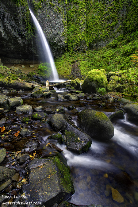
On the way back home, I did try to go hiking once in Oregon. I took my son and dog along with me in search of a winter waterfall. However, we came to a very narrow, snowy, and scary bridge. My dog Kaya would NOT cross it. She hates going across bridges to begin with, and this one was a bad one. I could not entice her to cross. So we had no other option but to turn back. And on the return hike, we came to the first bridge (which she crossed the first time without too much difficulty). But on the way back, she got scared and would not go across it. Oh great, now what do I do? I could not entice her back across this bridge, and there was no other way across the river and back to the car. My only option was to carry her across the bridge (she is a medium sized black lab, and not particularly light). Fortunately, she obliged this alternative, and let me carry her across the bridge without squirming or wiggling while I did so.

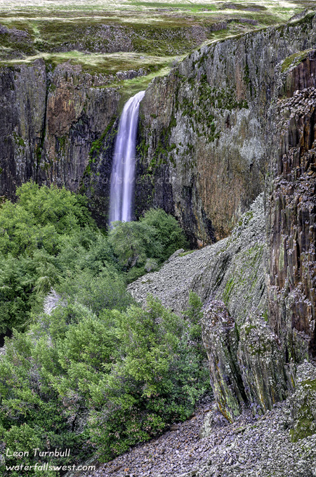
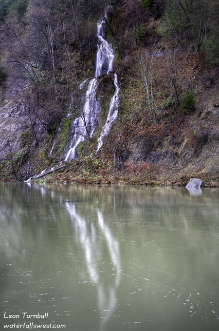
The only time I did go out hiking (successfully) while we were up in Red Bluff visiting my wife’s parents. I went out and saw three waterfalls in the Montgomery Creek area east of Redding. I had hoped to see more (there are still a few waterfalls in that area that I have not been to), but various circumstances prevented me from seeing more. On the first day I went out, it was raining. Hard. It was not even supposed to rain that day at all. The first waterfall I went to was on Hall Creek. It was actually a nice one, but I could not find any good vantage points to shoot the falls, as there was just too much trees and bushes in the way. It also took me MUCH longer to get to that one than I anticipated. Once I got back to the car, Kaya and I were pooped, and then it started raining. I waited quite a while for it to stop, but it just kept going and going. I drove up to Kinner Falls next (pictured here), and walked down to the river in the rain. It kinda let up a bit as I took this photo, but I think it was still raining, and this was the only decent shot I got that day. I was actually quite impressed with Kinner Falls. The only photo I had seen of this one made me think it was not very visible from across the Pit River (which is the only place you can see it). But it is really a very beautiful 139 ft. high falls.

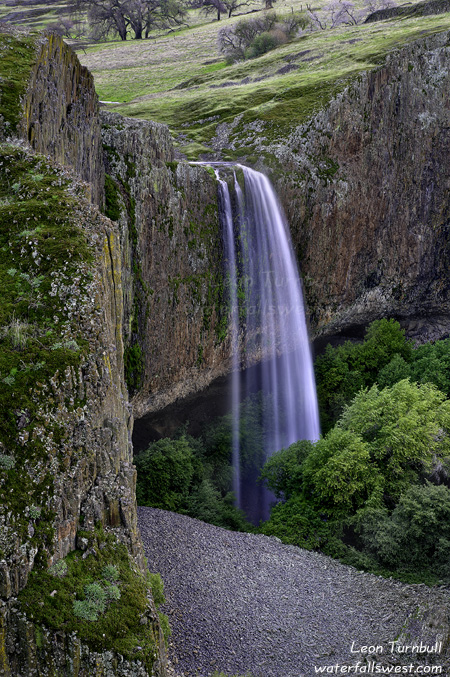
On a different day, I went back to the Montgomery Creek area, and went on a seriously crazy bushwhack along Marble Creek. Poison oak, thick brush, ravines, steep cliffs, you name it. It was only about a half mile, but it took a long time to get down to the falls.  In some spots, the brush was so thick it was almost impassable. I almost gave up a number of different times. But then it would open up again, and I even saw a trail. Was it a very old human trail? or a bear trail? I was not sure. Near the end, I saw a very well defined human trail which must have been made by loggers (it did not lead anywhere, but just sort of ended at a ravine). Anyway, the waterfall itself was a beauty, a 34 ft. plunge into a very narrow canyon. Unfortunately, all the photos I took of it were out of focus and crap. I have no idea why either, this has never happened before, but I’m sure it must be user error somehow. And I’m not sure I will ever want to go back to this one, as it was just too difficult. Sigh. Well, all these waterfalls (including a pic of the crappy out of focus one) are now posted on my website:

http://www.waterfallswest.com#recent

2 Comments

Flag Falls

    You are forgiven if you think this is Phantom Falls on Table Mountain (my previous post). It is not, but it does look eerily similar to its more famous neighbor. Flag Falls is about 1.5 miles further past Phantom Falls, and is not really too difficult to reach. The hard part was crossing the creek above Phantom Falls, which was flowing pretty well. I managed to cross without getting my feet wet though. After that, the terrain levels out and it is mostly flat cross country over to Flag Canyon. You can see Flag Falls from quite a distance away, and it is an easy jaunt up to this lookout close to the falls. I sat on a rock outcrop eating my lunch and enjoying the view. Flag Falls is a bit smaller (105 ft. high) than Phantom Falls, but it is another very beautiful plunging waterfall.

      For directions and more info on this waterfall, click here:

      http://www.waterfallswest.com/waterfall.php?id=957

        No Comments

        The Phantom

        On Wednesday, I headed up to Oroville to check out some waterfalls on north Table Mountain. It was “supposed” to be rainy in the morning, but cloudy with showers in the afternoon. Well, I arrived in Oroville in the late morning and it was sunny! Sun may be a very welcome thing for most people, but not for the photographer. I had a big hike planned to see multiple waterfalls, and I really needed it to be cloudy to get some decent shots. Well, I started my hike anyway, first heading straight to Phantom Falls, undoubtedly the prime jewel of the many waterfalls on Table Mountain.  It was sunny when I arrived there, but I did take a quick snap anyway. I have never seen so much water flowing over this waterfall. It was amazingly spectacular. If you look closely, you can see it dropping in three separate segments. Normally, this waterfall is just a thin ribbon of water plunging over the cliff in a single segment. But not right now. Wow, what an amazing sight to see this one at high flow.

        After stopping at the overlook for Phantom Falls, I continued on my 10 mile hike, past Phantom Falls. I was wondering how easy it was going to be to cross the creek above Phantom Falls. I was barely able to jump across the creeks for Hollow and Ravine Falls. I was sure I would need to get my feet wet at Phantom. And indeed, the creek was flowing wide and deep, a jump across would not be the wisest course of action on this day. However, after a little bit of scavenging upstream, I came to a fallen tree laying in the water. I managed to, with difficulty, hop onto a shaky log resting in the middle of the stream, then hop across to the other side, all without getting my feet too wet. It was interesting, but better than taking my boots off and wading across, and it was more fun this way as well.

        I continued on to the two other “new” waterfalls (for which I will post photos later). When I got to them, the clouds had rolled back in over the area. So thank the Lord, I had my overcast skies back, and I was able to get good shots of all these waterfalls. The overcastness lasted the rest of the day, and when I got back to Phantom Falls, I had good lighting. I wanted to try to get some shots from the other, non-standard, side of the canyon. This view is different and unique. Just don’t look down. Across the canyon, I could see some other people at the main viewpoint. I think I heard one of them whoop for joy when they first came into view of the waterfall (and as I found out later, he is one of my Facebook contacts – haha, small world).

        I really find this entire area incredibly fascinating. The canyons on Table Mountain are incredibly deep, the dropoffs are so sheer, and the landscape so very interesting. It is so neat how all the little gullies which start off as a gentle depression in the ground, then all of a sudden drop into a very steep canyon. They all have little streams flowing in them (in the rainy season), and many of them form large waterfalls, even the small streams. And interestingly, since the terrain is so similar, most of the waterfalls on Table Mountain have very similar form as well.  It is really a very amazing place.

        5 Comments

        A Bit Squirrelly

        Well we sure got dumped on this weekend. Lots of rain, and plenty of snow in the mountains (and it is still coming). I knew the waterfalls would be going crazy so I really wanted to get out. According to my weather reports, it looked like Monday might be the best day (it only said “showers”, not “rain”). That turned out to be quite wrong to say the least. It rained all morning long on Monday, and I got completely drenched hiking. Darn weather reports, anyway. You probably think I am a bit “squirrelly” to go out hiking in the rain, or if there is a possibility of rain. I suppose you would be right about that.

        Anyway, I had a few different thoughts on where to go, but I decided on trying out a couple new ones in the Grass Valley area. This one here is Squirrel Creek Falls. As you can see, the waterfall is flowing pretty crazily. For most of the year this creek is dry, but after a lot of rain it gets going. And we had a lot of rain. And it was sure going.

        The hike down to Squirrel Creek is pretty easy. It is actually private property, but it is open to the public for hikers and bikers (awesomeness). The road leads down to the bottom of the falls, where I found a lot of garbage (not so awesome). It is certainly a fabulous waterfall when it is flowing, and I measured it be 62 ft. high, but it was raining hard the entire time I was down there, and that makes it very difficult to take photos. I am not too happy with this one.  Oh well, perhaps I will just have to go back someday.

        After shooting this, I ventured downstream. There is another waterfall on this creek far downstream. I wasn’t planning to try to get all the way down to it, but I was curious if there was a trail. There was a trail and I followed it for awhile. But it led right to a house. It was a newly built house, but there was no one around, and it was seriously out in the middle of nowhere. I could see NO roads going down to it at all. It seemed that they would have to hike into their house to get to it.  It was very strange. Anyway, I turned around here, and I’m not sure if I could have followed the trail more downstream or not. It might be something to try another day.

        To see more information on this waterfall, including directions and maps, please see my website:
        http://www.waterfallswest.com#recent

        No Comments