THORN IN MY SIDE 

Is it possible to get excited about a 13 ft. high waterfall? Yes it certainly is, if it is as adventurous as this one. The North Fork of the North Fork of the American River is a thorn in my side, and has been, like forever. It still is.

I almost did not make this hike. I am sick with a cold this weekend. On Friday night, I went to bed and slept horribly. I even turned off my alarm. I was not going to get up early to hike. But then I woke up at 4AM, and was feeling a little better. Should I stay or should I go? I knew that I would regret it if I did not go. And I knew that I would regret it if I did go. What a dilemma. Well guess what? I got up.

The road to the trailhead was far worse this year than last year. There are a few spots that seriously require a high clearance vehicle. Last year, I made it over them without difficulty, but this year I found that someone had built up the dirt mound, so I actually bottomed out going over them. The first mound I got by, barely, but the second one I bottomed out. It was very close, but no cigar. Ugh! I turned my vehicle around, then drove back up past that first mound, which I found to be more difficult going up then down, but I got by it. So now what do I do? Go home and back to bed? That sounded like a very good plan. However, I was less than a mile from the trailhead, and I drove out here all this way, so why not just hike from here? That is precisely what I did, of course.

I have a new backpack for backpacking, and today I was taking it out on a test run. It passed with flying colors, and I cannot wait to try it out for realz next week. You would not think I would need a backpack to go on a day hike, but I actually did today. The trail descends down to the river, then you need to walk upstream to a certain magical place called the Pool of Cold Fire. If you are ever here when the light is just right, you can understand why it is called that. The very first time I was here, I had that amazing light, but not in the times I have been here since. The trouble is, the river goes through a very narrow channel here, with towering cliffs on each side. The waterfall (waterfalls) are on the far side of the channel, and just out of sight. There is absolutely no way to get to the waterfalls without going through this channel. It is impossible to scale up the cliffs on either side of the river. The only way is to swim. However, swimming with expensive camera equipment is not a good plan. Thus we proceedeth with option 2: Buy a raft and drag it (or carry it in my new backpack) all the way down to the river, inflate it, and paddle up the channel to the other side.

I was rather nervous about paddling up this channel. Could I really do it? Would the current be too strong to paddle up, or instead take me far downstream before I could exit to shore? Would I flip the raft and dump all my precious camera equipment to the bottom of the river? What if I got to the other side and punctured the raft, then how would I get back? What if a big rock fell on me as I paddled up the channel? So many horror stories went through my fragile mind.

As it turned out, paddling up the channel was very easy, and very fun, and I had no problems. Until … I got to the other side. There is a big huge rock in the middle of the river, and another big rock protruding from the side into the river. The two openings on each side of the rock were far too small to squeeze my raft through. The river was very deep here, and there were no footholds to climb up on the rock. I was stuck. I could not figure out how to get by this obstacle, and I was almost ready to turn around in defeat. However, I saw that there was a large flat submerged rock, and I was able to get out of the raft and stand on it, while holding onto one of the other big rocks. I had to be careful not to dump out my camera equipment or the paddle, or even worse, let go of the raft and have it float by itself back downstream. It was also a bit sketchy to stand on, and tough to find good footholds, but once I secured myself, I dragged the raft across the opening to the other side of the rocks, then I lunged with one of my feet across to another submerged rock, which I pulled myself up onto, then plopped myself back into the raft. All was good. I then proceeded to paddle up the rest of the way to the end. Going back across that obstacle was much easier. Thank the Lord.

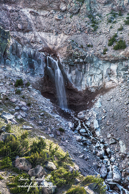
When I got to the end, I could see the waterfall around the corner. Not! It was hidden at the end of another deep pool, and around another corner. I dragged the raft through the deep river and up over some rapids and rocks, up to this other pool, then paddled across. At the end of this pool, I could see the waterfall, in fact it was awesome cool sitting there in my raft right up close to it. But there was no way I could take photos of it from the raft, and there was nowhere I could exit the raft here. So back I went, ditched the raft, and climbed up on the side of the sloping cliff. This was quite a bit sketchy, with dangerous dropoffs, but I was able to get in a position to photograph the falls, and back down safely afterwards.

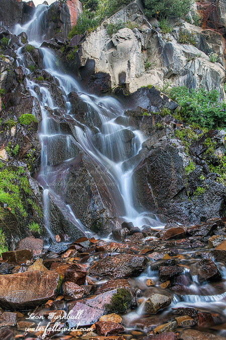
This 13 ft. drop is actually only the bottom section of Lower North Fork Falls. There is an upper tier around the corner, and another drop just above. I had high hopes that I could continue up river from here, but there was no doing that. Again, the cliffs on both sides of the river were massive, with no possible way to continue up past this little waterfall. The NFNFAR has skumped me again. Well at least I got to see this little beauty. It was not a big loss at all.

Rafting back downstream was much easier and more relaxing. The hike back up to the car was not precisely relaxing, however. It is a very steep climb, and the gnats were out in force, I ate more than my fair share of them. Wasn’t there supposed to be a nice wind today? Apparently not. It was tough carrying the raft and gear back up the mountain, but the backpack did well and I am pleased with it. All in all, a fantastic day on the NFNFAR.


3 Comments

THAT OTHER STATE

    I do not usually cross into Nevada to search for waterfalls, but when I do, I find one. Kidding. But seriously, if there are two waterfalls that I want to see that are the same distance from my home, one in CA and one in NV, I will choose to go to the CA waterfall. Why so, captain? Well it is because I want to be considered the guru of California waterfalls (or whatever you want to call me – pick a name – it doesn’t have to be a nice one), and there are just so many waterfalls still left to see in California, so I concentrate on going to see the CA waterfalls as much as I can, in order to continue to build up my bagged list in CA. But every so often, I feel like venturing into Nevada, and thus was the case this weekend.

      Waterfall season is done in California (and Nevada), but I thought perhaps this one in the Mt Rose Wilderness might still be suitable, since it is a high elevation waterfall. Not great, but at least decent. So after work on Friday, I took my son Jadon and drove up the hill, eventually crossing into that other state.

        I thought this was a very easy hike. It is only 2.5 miles with minimal elevation gain. Jadon did not feel the same way. He said it was a “moderate” hike. My family knows by now to always up the difficulty level from what I say it is, by one more level. They are not stupid. Easy is really moderate. Moderate is really strenuous. Strenuous is really just kill me now. I’m not sure, though, why Jadon thought this hike was “moderate”. Perhaps it was the high elevation. Pretty much the entire hike is above 9000 ft., so that could be a factor, but since it is mostly flat-ish, I did not think it to be an issue at all. Perhaps it was just his lazy, teenage mindset. That’s more likely. Anyhow, it was a good hike to the falls. It was definitely flowing “decent”, though I was hoping for a bit more water.

          My tripod head broke again, making it very difficult to take photos. I had said I fixed it, and that I was the man, and avoiding having to purchase a new $200 head. Well, I guess I am not the man any longer. I could not fix it again. The screws were still tight, and I could not tighten them any more, but it is still broken. So I am definitely going to need to buy a new one now. Bummer. I tried to take photos as best as I could.

            On the way down, we ran into not one but two large groups going up the mountain (to the top of Mt Rose). It was already almost sunset. It would be dark long before they got to the top. Usually I am always the last one off the mountain, but not today. At first I thought it was just a bunch of unprepared kids going up to have a party or something and not thinking about how they would come back down in the dark, but then a couple adults came trailing along behind them. They said they were going to the top to see the full moon rise, and hike down in the dark. Ok then, well that sounds like a very cool thing to do, however I’m pretty sure they did not make it to the top in time to see the moonrise. I would definitely like to go to the top sometime to be there at sunrise or sunset. That would be awesome, but not today. I was hoping to get a nice sunset view of Lake Tahoe from up on the ridge, but we could not even see the lake! It was so hazy in the valley from the fires in California, that you could not see anything down in the valley. There was a bit of nice color, and I did take a couple shots, but I don’t think I got anything very interesting. We arrived back at the car just after dark and made the long drive home. We had a good hike in the other state. 

              2 Comments

              IN SEARCH OF BOLAM

              I think this was the third hardest hike I’ve ever done, after Wabena Falls, and another hike I did in British Columbia a few years ago. It was all worth it.

              The elusive and mysterious waterfalls on the north side of Mount Shasta have had me pulling my hair out for awhile now. Whenever I drive by Whitney Creek on Hwy 97, it is always dry. It does not seem to matter when. Spring, Summer, Winter, whatever. In the spring it is dry. Why? You would think there would be some snow melt on this creek in a good year (which we had this year). It was dry this spring, but the actuality is that these waterfalls do flow in the summer, and when I drove by on our trip to Canada, I found that Whitney Creek had water in it. Finally. Three weeks later I came back.

              The plan was to hike up to Coquette Falls. It is 2300 ft. elevation gain in about 3 miles. Ugh. Cough. Phhttt. What was I thinking? I literally almost did not make it. There was not a trail the entire way, and I came to a very brushy area, which was so bad, I almost turned back. My legs got scratched up ridiculously, but I determined to persevere, and eventually came to a road, which got me up the rest of the way. The hike up was relentless. With about 300 ft. (in elevation) to go, I could not continue any further. I was done. But I could not stop now, I was too close. I kept going. Ten steps up, rest, and repeat. It took over 3 hours to get up this viewpoint of Bolam Creek Falls, 82 ft. high. It is a glorious spot, with incredible views of Shasta and Shastina, rarely seen from this angle, and far away down into the valley is Lake Shastina.

              When I arrived, the waterfall was in shade (as expected), but the rest of the area was not (as expected). I found a little tree that was blocking the sun, and I setup shop there to take photos. It would have been nice to have my big lens, but that would have been ridiculous to lug that heavy thing up the mountain. I most certainly would not have made it if I had been carrying it. There was not much in the way of clouds, but I waited until one little one passed in front of the sun, which helped manage the lighting on the scene. I waited quite a while more, but no other clouds presented themselves to help me (that was not very nice of them). I tried to eat food, but I could not eat much. I was too spent from the hike to even eat, except an apple, my pudding, and half of my sandwich.

              I could see that Coquette Falls was completely dry, so I did not go up any further. I seriously could not go any further anyway. My legs would rebel. Sadly, I think Coquette is dead. The glacier is not melting into that drainage any longer, there is not enough flow left from the glacier melt. I really wish I could have seen it when it was still going. Does anyone know Dr. Who’s phone number? The other waterfalls on this side of Shasta are dying as well. Bolam still has decent flow in the summer, however, but how long does it have left? I’d like to come back up here in the future and explore further, but that would be nuts. Of course, I said the same thing after I first went to Wabena Falls, then I went back to it. At least it was all downhill back to the car.

              No Comments

              FALLING 

              I got my daughter up early yet once again, she is a real trooper. We drove up the mountains in Bend to go on this very easy hike on Fall Creek.

              It was extremely cold up on the mountain that early in the morning. I even had to put on my long pants, the first time I have had to do that this summer.

              The waterfall is only 24 feet high, but it puts out a heck of a lot of mist. No joke. There was literally no place I could take a photo of this falls easily due to the mist. I tried my best, but I had to shoot from further back than I wanted to. It is definitely a fun little waterfall.

              My tripod ball head also broke. I do not understand what happened but it would not stay stable. That makes it difficult to take photos. I tried putting first aid tape around it (it was all I had!), but that did not work anyway. Well what can you do. Argh. Thankfully, I was able to fix it when I got back home (and not using tape!). I thought I might have to fork out $200 for a new one. I am the man. The waterfall madman.

              No Comments

              BULL-LONEY

              I managed to get most of the gang up at 5AM to go to this waterfall. My daughter, my mother, my brother-in-law Lynal, and even my niece Hannah. I was surprised they all wanted to come.

              This is a very easy waterfall to get to, right beside the road. It is a bit surprising that they had not been here before since they live so close to it. If I lived here, I would be going to this one and all the others in the area at least once a year. But my family? Why have they not been to any of these great waterfalls so close to them? I have failed them. Sigh.

              Along the way, we saw a bear and an elk. Elk are as common in Cranbrook as deer are in most other places.  The bear was cool. I find it interesting that my daughter saw zero bears in Alaska, but did see one in Canada. Canada wins! Canada also wins in hockey. Just saying.

              Bull River is dam controlled, but I knew that they were currently releasing water from the dam. However, the website said the current flow was 1200 ft.³ per second and this is definitely not 1200. It seems more like about half that amount, or less. The rest of it must be going into the powerhouse. Oh well. At least it is flowing decently well.

              The waterfall is right under the bridge pretty much, so that makes it a bit difficult to see. You can get right to the cliff edge, but no you can’t. It is very treacherous here, and although I inched my way out to the edge of the cliff, as close as I possibly dared to go, I still cannot see the bottom of the waterfall. From the bridge, however, I climbed up on the railing, and I was able to see the entire waterfall and take a photo of it. From this extreme angle, it makes the waterfall seem much smaller than it really is. It is actually 44 ft. high. That is your guaranteed measurement, and if you are in the area, why not come to see it? Don’t wait for 10 years to see it, like my family did. Sigh.


              2 Comments