LOOK MA, WATER!

Look ma, water! Is this Mars or is this California? What is your guess? If you said Mars, then I am sorry to say that you are incorrect (as unlikely as it seems that this would be California, and I can’t blame you for guessing Mars).

Of course, the big news from NASA a couple weeks ago was that they have apparently found tiny rivulets of water on Mars. I suppose that means Mars has more water than California right now. Sigh. But if they do have waterfalls like this one (or bigger), then I am wondering how can I get there to see them?

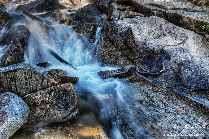
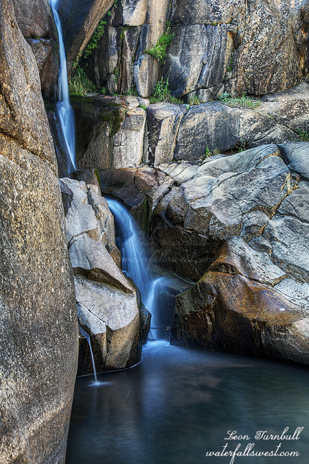
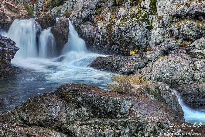
This is the South Fork Feather River and it is going right now at about 400 cfs. Obviously it is a controlled river, and every year they have a recreational release mainly for the kayakers. I really did not think they would have it this year, however, because of the drought. But surprise surprise, they did. I was here last year and despite the hecka long killer drive out to it and despite it being a small waterfall, I decided to come back again this year for a couple reasons: (1) I wanted to get down to it on the other side of the river where I would get a different (and possibly better) angle of the falls, and (2) There is nothing much else to see in California right now. (I’m serious: is there anyone that can take me to Mars?)

So it’s 4AM. Off we go … About 1800 hours later (give or take) I arrive at the dam and parking area. The water is flowing. That’s a relief. No kayakers in sight. I was a bit surprised about that but so much the better. I will have the waterfall all to myself today. I crossed the dam and scrambled up to the top of a ridge. I was thinking there would be a good trail traversing the ridge over to the falls. However, there really was not much of a trail and what there was was quite difficult to follow. Perhaps that is because I went off in the wrong direction, staying too high above the river. The route soon became far too brushy to continue. Dang. I was not expecting to have to do battle with the brush here. It was too late to try the other side of the river (where I went down last year). So, I backtracked my steps, and then tried a route further down closer the river, and fortunately I found a path through the brush and a slightly (only slightly) better trail too, which led all the way over to the waterfall. There was a big log blocking my way though. The only way past it was to go under it, and I had to shed my camera backpack to squeeze under, and as I did this I somehow managed to kick my backpack, which promptly started tumbling on its own downhill and towards the cliff, off of which it would promptly land in the river. It did not make it that far, fortunately, and stopped before it got to the cliff edge, but it did raise my anxiety level slightly. Needless to say, I was much more careful on the return trip, going back under that log. Once down near the falls, I found quite a lot of mist so I had to shoot from further back, but I had plenty of time before the sun arrived, and it was highly enjoyable. Such a long awful drive, but it was easily worth it to see some good water falling in California.

So what about El Nino and the big winter that is supposed to save us? I was really hoping we would have an early start to the winter this year, but it is October and we are still dry, and in fact was close to 100 degrees in late September and it still can’t seem to drop out of the 90’s (though maybe we are seeing signs finally that things will change in October). If we don’t get rain by December our reservoir will be dry (literally). It is currently 17 percent of capacity, and the 2nd lowest it has EVER been. And now for some more bad news: El Nino seems to be peaking already, or almost peaking. Remember what I said earlier about the two strong El Ninos that peaked early in summer/fall? Those two years of so-called strong El Ninos (1966, 1988) resulted in horrible winters in California. Now I am wondering if this so-called strong El Nino has peaked too early but hopefully it will still be ok, it has not quite peaked yet. Keep praying folks.

2 Comments

THE POSSIBLE?

I tried a new hike this weekend and it was almost really great. That is, to hike up above Horsetail Falls in the Desolation Wilderness without actually hiking up Horsetail Falls. That could be a challenge, yes? But I hate, really hate, the route up alongside Horsetail Falls. Of course I have done it before many times, but it freaks me out now in my old age. So how can I get up to the amazing area above Horsetail Falls without going up Horsetail Falls? The answer: Rocky Canyon.

Rocky Canyon is a steeper route and more difficult, but not so crazy treacherous and dangerous. In fact, it is not dangerous at all. The only problem is the brush, the awful brush. Indeed, I almost turned back, but persevered and found the way through, and after that the rest of the hike was easy smeasy.

However, I arrived at my destination, Ropi Lake, much too late. According to my calculations, the waterfall still should’ve been in shade, but it was clearly not. This is the second time in a row that the Photographers Ephemeris program screwed me over. Has anyone else found issues with this program recently? Well, I’m sure it was user error, and I will not be making this mistake again (he says so confidently). The sun still should have been behind the ridge, but it was well above it, for at least an hour or more, and I was not that late in arriving. Anyhow, I climbed out on the very slippery and dangerous logs to get in the middle of the creek, in order to get this shot of the lower part of the falls, which is certainly not a particularly good one.

On the way back, I passed through a campsite. The backpackers were gone off on a day hike, I saw them heading in the direction of Pyramid Peak. What amused me about their camp site, was the way they hung their food. It was horrendous! The food was strapped on a rope over a branch, only a couple feet off the ground. It would not have been able to prevent squirrels from getting into it, let alone bears. Seriously, you may as well just lay out all your food on a table cloth complete with napkins and utensils for the bears. A royal feast for them I would say.

I did hike back down along Horsetail Falls. I have never had trouble before going down that route, only going up. I knew there was one sketchy section but I was certain that I would have no troubles getting down. But alas, I was wrong again. There were a couple other sketchy sections that I did not remember even seeing before. One of them in particular was pretty crazy to get down safely. It was also darn hard on my old knees. Well, I did make it down and all in one piece. I’m definitely not too excited about trying that again. I would definitely do the Rocky Canyon route again though, if I can figure out a way to get around that awful brush.

2 Comments

THREADS

And this is exactly what God is going to do this winter all over California: weave this little thread together into a gigantic strand of waterfalls.

And I will be back to see it.

This was mainly a scouting hike today as I knew the creek would not be flowing much, in fact I wondered if it would be completely dry, but it turned into quite a fun little hike, even though I totally miscalculated the sun.

It was not exactly fun when I started the hike, and I was feeling quite unmotivated. Perhaps the warm weather had something to do with it, but I think it was mostly that I knew the creek would be just a trickle. The trail was easy going to start with, and thus boring, but after a couple miles or so I came to a very rocky section. At this point things started to become slightly interesting since it was a challenge to keep on the trail. But it was when I left the trail to go cross country, that’s when the fun started. Now what does that say about me, I wonder? It was a fairly easy jaunt through the forest down to the creek at the top of the falls, but there was no possible way to get down to the bottom on that side of the creek. The rocks were slick and treacherous, reminding me very much like at Horsetail Falls. So what to do? … I had to rock hop across, and then scramble around the cliffs to find a way down to the bottom. No problem.

Charity Valley Creek Falls is a cool vertical shot of 30 feet. Just a thread. The bottom of it was kind of in the shade, but my calculation said it would be completely in the shade by about 4 PM. Not so. The sun was still high in the sky and it would be one or two hours that I would have to wait. No thank you. Well I got a decent shot anyway. It was pretty cool being down here in the wilderness, with no other soul around within a 3 mile radius at least. This is what I love. And I will certainly be back here when this is a magnificent strand of waterfall. Next year.

For more info on this waterfall:
http://waterfallswest.com/waterfall.php?id=charity-valley-creek-falls-705

2 Comments

MINI ME

The planning was perfect. The execution was perfect. The result not so much.

It’s been awhile since I’ve been out hiking and waterfallin’. I normally do not hike much in the summer. The heat and the bugs do not agree with me, and eating too much ice cream  tends to mean I gain weight over the summer. It was 100 degrees on Friday, but dropping by over 10 degrees for Saturday. I thought it would be nice and cool in the mountains on Saturday morning. Yes waterfall madman, it is time to get back at it. This would be a perfect day to hike, and a perfect time to try to get to Mini Curtain Falls on the North Fork Stanislaus River.

Yes we are in a four year drought. Yes there is water flowing on the North Fork Stanislaus River. This river is a controlled river though, and it flows year round. Normally, however, it has about twice the flow at this time of year (give or take a little bit). So yes, the drought is affecting this river as well, but 110 cfs is still pretty good for waterfallin’.

I planned my route on Google Earth and I did an impeccable job of it (if I may say so). There is no trail down to the river. It is a 1300 ft. descent from the road, down through the forest, following bear trails and not much else. Lots of brush (but not too bad), and steep. Very very steep. This is my first waterfall hike in quite a while, and I guess I must be out of hiking shape. I almost did myself in on this one. I have been working out over the summer, but that is not the same as hiking up and down steep mountains. This one was a doozy.

I was quite certain that I would not be able to get up to the falls from along the river, due to the sheer cliffs on each side. I did go all the way down to take a gander, and yes I was correct. There was no way to get up close to it. That meant I had to climb up the cliff to where I could get a long distance view of the falls from a ridge. Google Earth shows a clear view of the falls from here, so I was fairly certain that IF I could get up there, then I would have a grand view of the falls. Wrong. I climbed up on the ridge without much difficulty (though it was not easy by any stretch of the imagination), and I got to the exact point that I had planned. I was even able to go further than I had planned. However, there was a big huge rock in the way. This rock is not showing any blockage of the falls on GE. It is a clear viewpoint. I even checked again when I got home. Nonetheless, the rock was there. I could only see the top half of the waterfall. I tried to find other vantage points. I made my darnedest effort, and everything I could do, but there was nothing doing. This shot was the best view I could find. The height of the falls is about 20 ft. (I suspect even a bit more than that), but the entire thing is not to be seen.

By this time I was quite tired from all the scrambling around. I still had to climb 1300 ft. out of the canyon. I took a rest (many rests), and eventually I made it back up to my car (barely, perhaps). I hope my body behaves a bit better on future hikes this winter. I have a ton of big hikes planned, and hopefully next time with better results.

No Comments

EL ANTICIPATION

The latest El Nino forecast has arrived and it continues to increase in strength. It hit the “strong” level in August for the first time. A key factor will be when it peaks. It not showing any sign of peaking yet, but is apparently forecast to max out in the December timeframe. If it peaks too early, it will not have the impact on our winter weather that we are hoping and praying for.

Despite what you may have heard from other forecasters, there have only been FOUR strong El Ninos since 1950. To clarify: four strong El Ninos “in the winter”; three of these had above average rain in California in the winter, and the fourth had “slightly above average” rain. Let me explain: The four strong El Ninos were: 1998, 1983, 1958, and 1973. As we all probably know, the first three had well above average precipitation for northern CA in the winter. No question about that. In 1973, however, I see about 103% of average precipitation for northern CA, noting that this strong El Nino peaked early in November (but still remained strong through the winter). Usually, forecasters referring to 1973 say it was an above average year for this strong El Nino, but I don’t think you can say 103% is “above average”, to me it is more “average”, but if you really want to then say “slightly above average”. The Southern Sierra may have been slightly higher that year.

There were two other strong El Ninos since 1950: 1966 and 1988. Both of these years had well below average winters for northern CA. However, it must be noted that both of these El Ninos were on the very low end of strong; the El Nino of 1988 peaked in the summer and was not strong when winter started; the El Nino of 1966 peaked in November/December and by January it was down to moderate strength. That is a very important distinction. Does it rain in the summer in California? No it doesn’t! So in the heart of winter, these strong El Ninos were not strong! Therefore, in my opinion, it is not appropriate to say El Nino was strong in those years if you are talking about predicting precipitation in the winter for California; they were moderate El Ninos during the winter of those years, not strong ones.

The other factor we have is the warm blob of water off the coast. In past strong events, this blob did not exist, and it also could be the reason we are currently in a four year drought. If it was not there, it is quite likely at least 2 of the 4 years we would have had average or above average precipitation. So will it affect the strong El Nino, and how? No one knows of course; personally I think it likely it will have some sort of negative effect, but the question is how much.

If we do have a big winter, I will be extremely excited of course. I was not living in California during the last big El Nino. I moved down here in 1999. I am already trying to map out where I will be hiking and what waterfalls I will be visiting this winter. Are you making your list yet? Pictured here is the Lower Middle Fork Tuolumne River Falls, 182 ft. high. Is this going to one of the waterfalls I will be visiting? Perhaps it will, though it is not specifically on my list (but nonetheless, I will be visiting this area for sure next year). If you have not seen it yet yourself, then you will certainly want to put it on your list. It is going to be amazing next year at high flows.

No Comments