MADNESS IN THE MIDDLE 

If the new falls on the North Fork American River was my number one destination to get to this spring, then this one was my number two: the Middle Fork American River. I suppose you didn’t know there was any waterfall on the Middle Fork American River, who did? But yes, not one waterfall but two waterfalls!

I actually tried to get to this one a couple weeks ago when I went to Picayune Valley Falls, but I failed and failed miserably. I bonked big time. It is only a mile up the canyon but a gain of 1000 feet in elevation, and terrible terrible brush. It is absolute madness to try to get up there. I was at first trying to get to Picayune Valley Falls (which is 4 1/2 miles), in time to get good lighting conditions, but I had a late start, so I was hoofing it the whole four and a half miles as fast as I could, and by the time I got there I was not a little bit tired. After that I tried to go up the Middle Fork Canyon, and I only got halfway, mostly because I went up the wrong side of the river which was just far too brushy and far too tiring.  Even after taking a rest and lunch, I could not take another step upwards. But no matter, I can always try again another day. And so I did.  And this time I would not bonk.

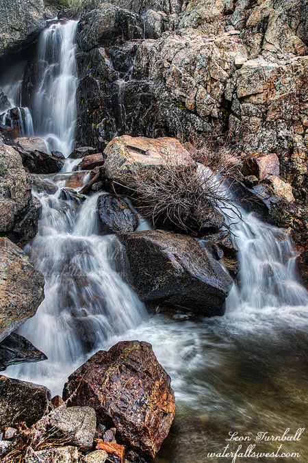
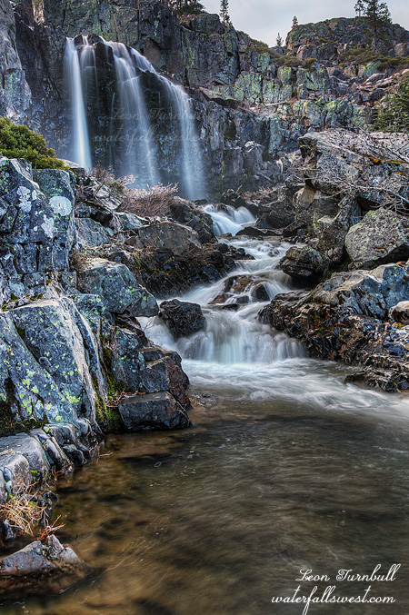
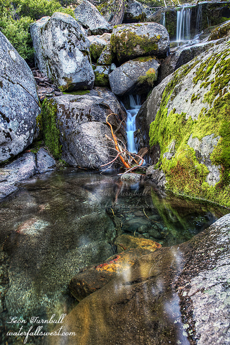
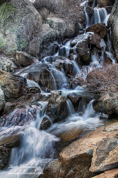
But that does not mean it was not ridiculous. I tried the other side of the river this time, and it started out much better, but as I ascended the 1000 feet it became more and more brushy. And when I say brushy, I mean crazy brush. Eventually I had to cross the river again back to the bad side. That’s how bad it was. It is perhaps a good thing we have a drought right now because otherwise this river would be raging and I could forget about crossing it. I do not mean that of course, the drought is just plain awful. It took me a full one and a half hours to hike the 1 mile up the canyon, but finally I got to the waterfall. It is a dandy one too, a lovely cascade 49 feet high. The sun was just starting to hit the falls when I got there, but I took some quick pictures before it was too late. I had no time to explore any further, because I had to get back to Auburn in time for my nephew’s birthday party. And as it was, I was late to that but it was worth it, I finally got to the Middle Fork American Falls. There is a smaller lower Falls on the river as well, and I took pictures of that and will post it soon. It was a great day in the Sierra, full of madness.

2 Comments

THE SOURCE

I am very pleased to present the ninth and final waterfall on the great North Fork of the American River. My favorite river in the world. It has been awhile in coming. Technically, it is the first waterfall on the river, but it is the last one found and documented. This was the number one destination on my list for this spring, when I first discovered this waterfall last summer, and once the snow started melting (what little we had), it was time to make the trip. Actually I was probably a couple weeks too early, I do not think this has reached peak flow yet this year.

The hike starts out at 6200 ft. elevation where of course this is no snow at all, and quickly and steadily climbs up to 8000 ft. elevation. A tough climb indeed, but it is steady gain, nothing horribly steep, and I made very good time. Nonetheless, it was sure nice coming back down the mountain later. Around 7800 ft. I hit the snow, and a lot of it. I expected perhaps 1 ft. of snow at the most and was thinking it would be quite easy to walk on. Instead, I found 3 ft. of snow. This made the walking quite difficult, and I sunk in plenty of times. I tried to follow on the coyote tracks which did not sink in, but apparently I am heavier than coyotes. I should have had my snowshoes, but I didn’t even consider it because I did not think I would need them (plus, I really would not have wanted to carry them up the mountain anyway). Up at 8000 ft. is where the North Fork of the American begins at a small, ordinary, and ice covered mountain lake. The river was just a trickle up here. It is funny how this little trickling stream can become a raging river a few miles down hill. I was fascinated in seeing the river at its true source. From the lake, the trail descends (though there was no trail seen under 3 ft. of snow), and the river slowly but surely picks up steam until I get to the river crossing at the top of the waterfall. It was simple enough to rock hop across the river, and the rocks looked completely dry. Until I stepped on one that is, and found out too late that it was not dry, but instead it was wet and very slippery. And indeed I slipped, smashing my shin on the rock. Oh the pain. I stood there for a good five seconds trying to recover, then realized my boot was still in the river and getting my foot quite wet, so I picked it up and hobbled across to the other side, and continued the recovery for another five minutes. No real damage other than a very bruised shin. It could have been worse.

On the other side, I made my way (much more carefully) down to the falls. There was a lot of brush to negotiate on this side, and it was a bit steep, but I got to the bottom where I found this little beauty. This waterfall has a total height of 107 ft., but it is in three separate tiers that can only be viewed one at a time. The nicest is the bottom tier shown here, which is 40 ft. high. It does not look 40 ft. high, but I measured it a couple times. So it must be true. That’s what I say, anyway. It would be nice to see this waterfall at full blast, and I am sure I will be back sometime in the future to the source of my favorite river. It was a magnificent day in the Sierra.

No Comments

LAST GASP ?

I took Monday off work and headed up into the mountains.This particular place was not where I wanted to go on this Monday morning, but it is where I ended up. There was more snow on the ground than I expected from the “small” storm. Well, it’s not like more snow fell than they were forecasting. There was only a couple inches, and that is not a problem for driving in, except the road I was going on was very steep, and as I drove higher and higher, it got steeper and steeper, and icier and icier, and that would mean it would be more and more harrowing to drive back down it later. So I gave up and went to Plan B.

Plan B was the Upper Truckee River, which of course I have been to before. This time, however, I would go much further than I had ever been before. Where no one has gone before. Not even Jean Luc Picard.

Well of course the weather forecasters were wrong again. It was supposed to snow more in the morning, and not break until the afternoon. That would give me all morning for hiking to multiple waterfalls in good light. Yeah right. The sun was already breaking before I even started my hike. I barely made it to this waterfall in time, and when I got to the upper falls, it was in full sun. I only took this one photo all day long.

From the upper falls, it would be another 1.5 miles of hiking to get to my planned destination. That should be easy. But it took forever! It seemed like I was in a time warp and not making any progress. My legs were moving, my body was getting tired, but I was not going anywhere. There was some brush, there was a marshy area I had to go around, and there was a decent sized lake I found that was not marked anywhere on my map, but it wasn’t really all that difficult and it should not have taken so long. I thought of turning back plenty of times before I finally got to the spot where I would need to cross the river. There were plenty (actually hundreds) of fallen logs in this area, and on some of them perhaps I could have crossed, but they all seemed to be either far too slippery or far too unstable, or both. I eventually decided to just get on my water shoes and wade across. On the other side I kept my water shoes on and continued trudging through the snow. You might think that I would get frostbite very quickly by doing that, but I had on my neoprene wet socks, and they kept my little toes quite warm. It was not too far up to the falls from there. Except that there was no waterfall! I was so certain there would be another waterfall up here on this river, but it was not to be, not even a small one. C’est la vie, as Jean Luc would say. You win some and you lose some. It was still a very fun hike through the fresh snow in the mountains, and exploring new places. Time to go down, cross the river, and back to the car. It was much quicker going back down, following my tracks in the snow. The big question is, will we get any more of it? Or was this the last gasp of winter? I sure hope not.

No Comments

THE QUICK MELT

The snow is melting! The waterfalls are flowing! Of course, the trouble is there is not very much snow to melt this year, less than 20 percent of average, possibly the worst year ever! So in other words, the waterfalls will certainly not be flowing for long this spring. Get up and at ’em now, folks!

I’ve had this one on my list for awhile, but I’ve always dismissed it because it seemed like such a long drive and such a long hike. Well, there is no time like the present, and I decided to go for it.

It is a very very long drive out to the trailhead for Picayune Valley, which is past French Meadows Reservoir (which, by the way, was only about a quarter full – really awful). Before I got there though, I discovered that my maps did not get loaded into my GPS. Ugh! If you remember, this happened before when I went to Middle Big Kimshew Falls. Well I realized at that time, the reason was that my memory card died. So I got a new memory card, and all was quite well after that. This time I am not sure what happened, though the problem seems a bit different. It might be my GPS that is dying now. I sure hope not because I really love my GPS. Anyway, no maps means great difficulty in knowing where to go. The waterfall is along a well maintained trail, though, and I was pretty sure I could get to the falls, “if” I could find the trailhead. That was a big “if”. If the trailhead was signed, then it would be no issue, but I did not know if it was signed, and if it was not, then I would be utterly lost. So good news, the trailhead was signed. All is well, and I began my hike.

Right at the trailhead is a creek crossing. Without a map, I was not sure if this was the river or not. The trail is supposed to follow along the river and I should not cross it here, but it did not look like the river. Yet it was sure flowing like a river! In fact, it was Talbot Creek, which I did need to cross, and it was flowing strong. Too strong to rock hop across, so I had to shed my boots and wade across. Well that is good news and it would mean the waterfalls would be really good as well, but I was already quite late starting, and I was concerned because Picayune Valley Falls would be in the sun early, and it was a 4.5 mile hike to get there. So I booted it. As fast as I could hike. About 3 miles in, there is a crossing of the Middle Fork American River, and it would have stronger flow then Talbot Creek of course, and I had been worried that I would not be able to cross it at all. Yet it was strange because I could just rock hop across the river. That is because there were some huge rocks in the river that I could get across on. No need to get the feet wet again.

When I finally arrived at the falls, I found it still in shade. I was very tired from the fast paced hike, but I made it! I worked my way down to the bottom of the falls, and it was absolutely gorgeous! Picayune Valley Falls is 41 ft. high, consisting of multiple segments. So very pretty, and I am glad I finally made it out here. It is certainly worth the long drive and hike! I was stuck with the single viewpoint shown here, the creek was flowing too strong to cross, and I could not get closer because the rocks were complete ice. It was a beautiful “spring” day in the Sierra.

3 Comments

PURDY THING

Well it’s not much, but this is what I got to this weekend. Yet I do think it would be very very pretty at higher flows, and I would not hesitate to return here in the future, if I know the creek is flowing well. This is East Panther Creek Falls, 25 ft. high.

The trip had a very shaky beginning to say the least. I was stopped for speeding. I was only going 15mph over the speed limit, and going down a hill. My big SUV picks up speed very quickly going down hills, and I do not like to press the brake so frequently. I had not been speeding on the drive thus far, but at this particular moment, I was not paying attention to my speed, and there he was waiting at the bottom of the hill. Dog-gone-it! When he took my license and registration back to his car, I started praying fervently. Please Lord, let this just be a warning, I cannot afford a big expense like this. Well in less than a minute, he came back to the car and told me he was just giving me a warning. Wow! How amazing is that! Thank you Lord, and thank you Officer! Now Lord, how about another miracle and please send us more rain next week! That was my next prayer. It is a bit interesting because two days ago, the weather forecasters were saying “increasing confidence” for us getting rain next week, and for the rest of the month as well. Then just yesterday I looked at the forecast and all the rain was completely gone from the forecast. Are you kidding me? I was totally depressed in seeing that Friday, and even more so as I headed out hiking Saturday morning. And yet, when I looked at the forecast Saturday afternoon? The rain is back in the forecast for next week! It doesn’t seem like it is going to be very much rain, but I hope this is another answer to prayer.

I anticipated there being quite a lot of snow at 6000 ft. when I started my hike. They had a foot or more of snow on the I-80 corridor last week, but down here the snow was all gone. It seemed like they got a lot less here, only about two inches or so, and most of it had melted. I should have checked this area before I came, but I did not think of doing so. Why would I think they had so much less snow in this area? Well I guess I wouldn’t need my snow shoes. As I hiked along, I first came to West Panther Creek, and it was barely a trickle. No snow to be found. East Panther Creek is about the same size drainage, so things were not looking very promising, yet when I arrived at that creek, I saw that it did have quite a bit more flow, and there was more snow around as well. It was not very great though, I was anticipating this creek to have a lot of snow melt happening today, and would be flowing quite well. Not even close.

I was not sure there was a waterfall on East Panther Creek, just hoping that I might find something. I started hiking up the canyon, and the going was very easy at first. Before long, however, the terrain got very brushy and much steeper, as the walls of the canyon closed in on me. I had to cross the creek multiple times, and climb up through the brush and through the creek to keep going forward. I somehow lost my bear spray along the way as I battled my way through the brush. I was going to look for it in earnest on the way back, but I decided to go a different route. Speaking of which … my wife just told me about a water bottle she forgot at a certain place and had a friend go pick it up for her, so she bought her flowers as a thank you. Really? A bouquet of flowers for a water bottle? The lady did not have to go out of her way at all to go get it. Geepers, that is too nice. Well … I guess what I am trying to say is that if you come up here and find my bear spray and return it to me then I will buy you a bouquet of flowers. Or if you’re a man, perhaps a case of beer would be a better option.

I finally made it up to where I thought there would be a waterfall, and voila, it’s a waterfall! It was 25 ft. high, just making it above my 20 ft. limit. And it was a pretty one. As I said, I really want to come back here when the flow is better, but coming up along the creek bed at high flows would not be do-able. I thought about it and decided it might be better to go back by climbing to the top of the ridge, hike back along the ridge, eventually getting back to where I started. No creek crossings necessary. And it worked pretty well. It did get a bit brushy, but all in all it was a much better route. I shall return.

2 Comments