RE-DO

So after my hike at Mile Hill Creek, I decided I just had to go see 144 ft. high Canyon Creek Falls after all. I am still looking for that monster flow at Canyon Creek. Would I finally get it?

It was wet and rainy, a perfect day for a hike. The rain was mostly light though, so I did not get too wet … until I slipped on a log while crossing over a stream, and ended up with both feet planted right in the water. Doh. Why I thought that flimsy log would hold my weight, I have no idea.

It is a pretty easy hike down to the overlook at Canyon Creek, and I made it in good time, picking up a couple ticks along the way – which I promptly sent along their way, over the cliff. I hope they had a nice flight.

It is a bit difficult to know exactly what the river flow was when I arrived because there is a delay in the water reaching the gauge at the North Fork Dam. The North Fork American River peaked at just over 10,000 cfs from the Rain-Ocalypse Part II, but that was in the middle of the night. By the time I got down here, I estimate it was around 6000 or 7000 cfs. We picked up 8.5 inches of rain in the Northern Sierra foothills, but it was all spread out. The river level was up and down all weekend. The river looked to be raging and much higher than when I was here in December (when it was around 4000 cfs), but Canyon Creek Falls looked exactly identical to how it looked in December. I could not even tell any difference from comparing my two photos. I guess I was hoping it would look a lot more impressive with higher flows, but it seems not. Nonetheless, I will still keep coming back here in the future. It is an amazing place. Unnamed waterfalls were streaming off the mountains. I could barely make out Lovers Leap in the distance through the fog. The Big Waterfall itself was almost in fog and I was fortunate that I was able to see it. It was an incredible day in the North Fork American River canyon.

No Comments

RAIN-OCALYPSE PART II

The rain-ocalypse returns for an encore. And a much needed one at that. After one and a half months of zero rain, we finally got our rain back. The forecast was for about 8 inches of rain in the Northern Sierra foothills over this weekend. We got four inches on Friday night, and there is another system coming in Sunday night. I am not sure if it will end up being quite 8 inches overall, nonetheless, it is a very welcome relief.

And it is a direct answer to all our prayers. It is interesting to note that the first blip of this storm on the radar came precisely on the day of our church’s fasting/prayer day. Co-incidence? At first I did not think very much of it because it was only about an inch of rain. Of course that is much better than zero the day before, but still, an inch is really nothing considering that we need so much. Then about four or five days afterwards, the forecast became clearer. It looked like we were going to get hit with a Pineapple Express big time. As the week progressed, the forecast kept getting better: 5 inches, 6 inches, 7 inches, 8 inches. Try not to get too excited, Leon. I know it has nothing to do specifically with our church, we are certainly not the only ones in California praying. Thousands of people have been praying in California, and we need to be, and I know it makes a difference. I suppose the atheist would say it is just a co-incidence, but the rest of us know better. Still though, this one storm is just a drop in the bucket of what we need in California, we are so deep in the hole, you might wonder if we will ever get out of it. I will do a more complete analysis of Rain-Ocalypse Part II when it is all over and have a post later in the week.

So where should I go hiking on Saturday, I pondered? It seemed that it would be a very rainy and wet day, and I did not feel like doing anything very hard or long, yet I also wanted to go somewhere new. Well that pretty much eliminates everything because I have already been to everything easy in the area. I thought about going back to Canyon Creek, thinking that it might be in monster mode but when I woke up on Saturday morning, the North Fork American was only at 500 cfs. It seemed that the rain had not picked up the river flow much at all. I should have gone however because only two or three hours later the river was at almost 6000 cfs. It would have been pretty awesome there. Hmmmm … I wonder …

Well I decided on an easy hike: Mile Hill Creek. I knew there was a waterfall on this creek because you can see it on Google Earth, but would it be flowing well enough? It did not seem so. The creek flows right beside the trailhead, and it looked pretty meager there. In fact, it was about the same flow when I was here a few weeks ago (on a different hike). This area did not get much rain, apparently. I was expecting the creek to have about twice this amount of water in it, and I was disappointed. Well, at least it was flowing. I figured since I was here, I would just do the hike anyway. Down at the bottom of the canyon, the creek would have a bit more water in it, and I still did not feel like driving up into the mountains today, though I am sure it would have been much better.

It is not a difficult hike down to Mile Hill Creek Falls. It is all on the road or trail, and the trail comes right to the base of the falls. It is really a beauty. I was expecting it to be more of a cascade and much smaller, but instead it is a gorgeous 91 ft. tiered vertical drop. How did I not ever come here before? Even though the trail comes right to the bottom of it, the angle is too severe there for taking photographs. I had to climb up on the side of the mountain. That was darn tricky. I may or may not have had one foot off the edge of a cliff and the other on a narrow crumbly ledge while I took this photo.

On the way back I came across a couple that were hiking along the trail. Actually, they were not hiking but examining my footprints in excruciating detail, apparently trying to determine from my prints if I was male or female. “Well, speak of the devil”, they said as I came up to them. “How far did you go?”, they asked. Just up to the waterfall, I said, thinking that they would have no idea in the world what waterfall I was talking about. But they surprised me: “Which waterfall? There is more than one”. For a couple seconds, my brain was going at 100 miles per hour, trying to determine if they knew of some waterfall that I did not know about. Then it dawned on me: No, I am talking about that big one, the 91 ft falls, not the piddly little 10 ft. cascade just up ahead. The other one I would not even consider to be a waterfall (which I definitely wouldn’t, though I admit it was somewhat interesting). “Ah, well did you see the bear poop just a bit back there?”, they said. Ummm, that is horse poop ma’am, not bear poop. I do know the difference between those two types of poopage. “Okay then, well enjoy your day”. Thank you, and you enjoy your little 10 ft. waterfall, and also try not to fall off the cliff while photographing that other one.

Well, that is sort of how the conversation went (in my head, at least).

I did see a bear coming down the road on the way back, however. Or it might have been a big dog. Whatever it was, it did not attack me and it seemed quite friendly.

And that was the beautiful morning I had in the midst of Rain-Ocalypse Part II.

No Comments

FEELING BLUE

My plan was to hike to Fantasy Falls on the North Fork Mokelumne River. I did not make it. But it was still a great day.

It is a long long long drive out to Salt Springs Reservoir. Along the way I saw two skunks and three raccoons in the road. That is a lot more wildlife than I usually see (not counting deer, squirrels, and birds). The first skunk was hilarious. As I drove up, he waddled off down the middle of the road with me following. He would not get off the road, even though there was plenty of opportunity for him. I could not pass him because the road was too narrow, so I followed him for a long time; finally he got off to the side so I could pass. The first raccoon did the same thing, except he took off at lightning speed. I did not think racoons could run so fast. According to the “internet” their top speed is 15mph, but I am certain this one was going quite a bit faster than that.

After all that adventure, it was time for an adventure of a different sort. I arrived at Salt Springs Reservoir in the dark, but I could not find where the picnic area was. There were no signs, except for one very unhelpful one. I even started walking down one path thinking it must be in that direction, but soon realized I was going on a very wrong path. By the time I finally found the correct trailhead, it was already getting light and I had wasted quite a bit of time. Argh. It is a very long 5 mile hike to the end of the reservoir. And mostly boring. How exciting is it to walk along a big reservoir, a reservoir that is incredibly low. How low was it, you ask? The reservoir is 5 miles long in length and quite wide of course, but right now it is only 3 miles long in length and probably only about 1/4 full in those three miles. Two miles from the end, there is no reservoir. There is just a river. The river was flowing pretty good, and actually too strong to cross (as I would find out later), but at this time of year, the reservoir should be mostly full, not so completely empty. Stupid drought. I’ve sure been saying that a lot lately.

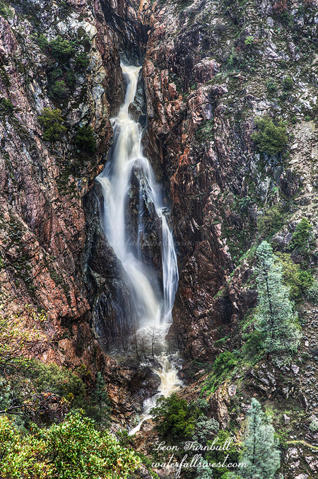
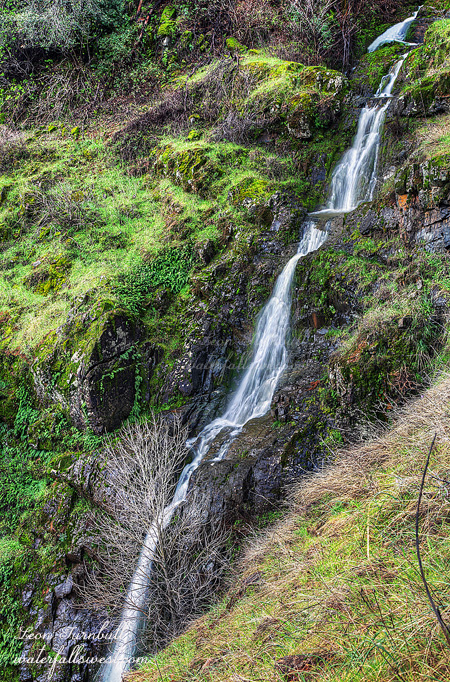
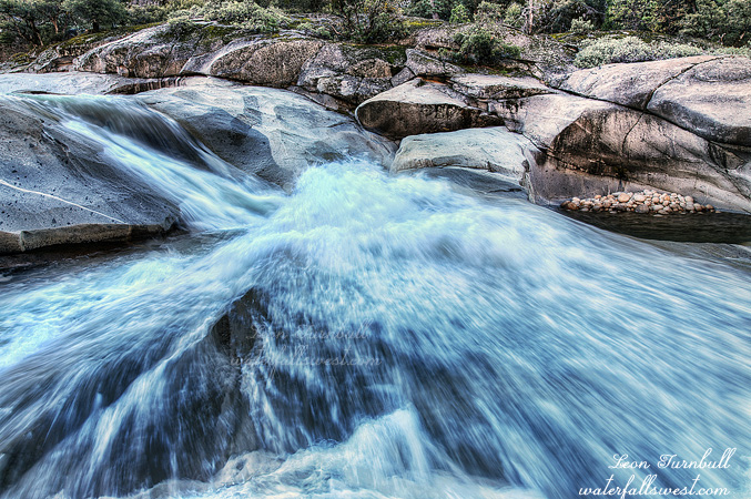
At the end of the boring five miles you will find the Blue Hole (pictured here). At first I was not going to take a photo of it, thinking that it was too small, but I decided to go down to look at it, and when I got up to it, I thought it was just so cool, the way it slides down and hits a big rock ledge in the middle, sending the spray straight at you. So I just had to take a picture. I also measured it and found it is 24 ft. high in total, so actually it qualifies for inclusion on my website.

From the Blue Hole, the boring hike along the reservoir ends and the real fun begins. There is no more trail and it is another two miles up to Fantasy Falls; I really had no idea if it was possible to get to it via hiking. I had heard and read nothing about anyone ever doing this before. As I examined it on Google Earth, it looked feasible except for one particular spot, which looked extremely iffy. Then a few weeks ago, I found an entry on the internet where one guy claimed he hiked 4 miles up from the Blue Hole. Yet he mentioned nothing about Fantasy Falls, which he must have passed. I even wrote to him about it, but his response made things even more unclear. He said that the picture on his website was of Fantasy Falls, but it was clearly not a picture of Fantasy Falls. I highly suspected that he did not hike 4 miles up the river, and that he never did make it as far as Fantasy Falls. And now, after hiking up there myself, I am pretty sure that is true.

Yet there is a trail from the Blue Hole. It is very faint in places, and I lost the trail many times, but always came back to it. I finally got to the extremely iffy spot, where the cliffs come right down to the river. There was no continuing on from here. There were two options: cross the river, or attempt to climb up above the cliffs. I tried the river crossing first. I made it halfway across, at first it was just up to my thighs, but then realized I would not be able to make it the rest of the way. The river became much deeper and swift to continue any further. It was darn cold too. Strike one. What about the cliffs? Well, I made a few attempts in different places, and continually had to turn back down. Finally, on the very last try, I found a way up to the top, and I could see all the way up river (Fantasy Falls was out of sight, around a corner). The view of the Mokelumne Wilderness from the top of this ridge was absolutely stunning. The beautiful valley stretched out before me, with snow covered mountains way off in the distance, and towering cliffs looming over me from across the valley. I was in awe and wonder, and in a very real way it reminded me of this awesome song by Geoff Moore:
Every mountain, every valley
Your creation, it surrounds me
Every breath I breathe, every heartbeat
Every sunrise that You give to me
These and so much more, tell a story we cannot ignore
The evidence of God

I could also see that it might be possible to continue on and I actually might make it all the way to Fantasy Falls. However, by this point I had reached my turning around time. You should always have a turning around time, the time that you absolutely must turn back if you have not reached your destination. It took a lot of extra time attempting to find the trailhead, crossing the river, trying to find a way up the cliffs, and now I had reached the time limit. The waterfall was still a long way away. I estimated that it would be at least 45 minutes more to reach it, if not more. If had continued on, I would most definitely be hiking back in the dark. I had no light with me, I would have run out of water, and I would certainly be bonked from the hike as I was already at my limit physically, and I would probably be stuck out in the dark all night with the mountain lions (and skunks and raccoons). It was time to hike back. As it is, I made it back to the car only an hour before dark. Another 45 minutes up to the falls and back, plus time to photograph it, you do the math. Anyway, the good news is that I think it is actually possible to hike to Fantasy Falls, and I will definitely try it again now that I know the correct way to go. It probably won’t be anytime soon, but I will be back someday.

No Comments

SHAKE, RATTLE, AND ROLL

After Donner Summit, I headed back quickly to Cisco Grove for my second hike (well, as quickly as I could without getting a speeding ticket of course). It was a 3 mile hike, but I estimated that I had plenty of time before the sun would be shining on the waterfall. Yet I was still worried about it. The sun was already high and seemingly already shining brightly in the canyon. Did I miscalculate?

There was a big no parking sign at the trailhead, so I had to drive back up the road a ways to a big turnout. Could I park here? There were no signs indicating not, but I was not sure. As I was contemplating this, a cop pulled up behind me. I was going to ask him if it was ok to park here, but he took off. I guess that means it is ok to park here? Well that is just what I did (crossing my fingers that it would be ok). As an aside, when I came back down afterwards, there were three cars parked where the signs said no parking. I wonder if I could have parked there as well? I’m not sure I would want to take that chance, though. Another strange thing I saw as I started up the road, which passes a campground. There were a ton of people tent camping there. This is winter, high elevation, and the temperatures are below freezing at night. You would think maybe one or two crazies might be camping at this time of year, but the campground was almost full. I think it was some kind of special event or something, but it was very strange to see it.

Anyway, the good news was that Rattlesnake Creek had quite a bit of water in it. I was even quite a bit surprised. I am pretty sure the creek is dam controlled, so I guess the lake above was full and spilling. I was not complaining about it, anyway. I made a quick stop at the lower falls and photographed it from the road. I didn’t take much time as I was worried I didn’t have any time. I also discovered another surprise waterfall further up the road. I did not stop at it on the way up. Again, no time. I should have stopped, but I’ll come back to it some other day. I finally made it to the upper falls. It is hidden in a canyon, blocked from the sun, and it turned out I had plenty of time to photograph it, but not an overabundance of time so it was good that I hurried up to it as I did. It is a pretty fantastic 46 ft. high waterfall, crashing over the rocks into the little canyon, and it is nice that you can pretty easily get right up close to it. I’d definitely like to come back here when the creek is going at full tilt. It would be amazing. I spent a bit of time here enjoying the falls, then made my way back down the road where I found my car still there and not towed. It was a great day in the Sierra Nevada.

No Comments

LONG OVERDUE

I have known about Donner Summit Falls for some time now of course, but had never been there before. You can see it as you whip by it at 80 miles per hour on I-80. Oops, I think you just rear-ended that slow moving car in front of you when you cast a glance over at the falls. Seriously though, why have I not been here before? Well … well … no good excuses really. Except that it is an awfully long drive up there, and all just to see a roadside waterfall? It is in the full sun pretty much the entire day and flows only in the spring, there’s nothing really else in the area, and just how big is it anyway? It didn’t really seem worth the effort. Plus I was not really sure how to get to it.

But … I had to do it sometime, right? And so I came up with a plan. I would go see Donner Summit Falls, arriving at sunrise, and then I would have time to go on a second hike to a second waterfall in good light as well. Now what about how to get there? There is no place to stop along the freeway. Well, maybe there is a way, but it seemed better to approach it from the other side. Perhaps I could hike down to it from the rest area. It would be quick and easy, and give me lots of time to get there by sunrise and get in that second hike as well. However, when I arrived at the rest area, I found a lot of signs, NO TRESPASSING signs. Doh. This would not work. Ok well what about from the Boreal ski resort? There is a trailhead there for the Pacific Crest Trail and that trail takes you close to Donner Summit Falls. So I drove all the way down to Donner Lake to get back on the freeway going the other way and back to Boreal, where I got to the PCT trailhead, still in the dark. I could not see where the darn trail started in the dark, however (even though I was right next to it). I guessed that with all the snow, it was not traveled in the winter. Well, I spent a lot of time trouncing through the snow in the forest, then finally got on the trail proper. It actually was quite well traveled, and now it was easy to follow. When I got over towards the waterfall, I got off trail, got on my snow shoes, and made my way down to the bottom of the falls. I didn’t quite go the right way, however, and it took longer than it should have. I finally got to the bottom of the falls, 10 minutes past sunrise, and the sun was already starting to hit the falls. With all that extra trouncing around, I was just a bit too late. But actually the photo turned out pretty nice. The comp was difficult. It would have been much better to shoot it from the other side, but it was too icy and I could not safely cross the creek. Still though, not too shabby. Donner Summit Falls is 34 ft. high, and if you can ignore the traffic whizzing by above you, it is a sweet one.

Speaking of long overdue, where is our snow and rain this year? Still much of nothing in the long term forecast. What little snow we have is melting quickly. The only reason Donner Summit Falls is flowing is because the little snow that is melting.

And here is another thing that I do not understand. At the PCT trailhead at Boreal is a mess of broken sleds. Not only at the trailhead, but scattered in various places along the trail. This is a popular area for sledding, but what the hey? If you break your sled you have to just litter it along the trail? Why are people such idiots that they cannot take their broken sled and dispose of it properly? Ugh! End rant.

2 Comments