DEJA VU

Does this winter weather seem familiar to you? It seems to me that it is shaping up to be exactly like last year, just like the last three awful years. Deja vu. We had a good start to the winter in December (just like last year in November), then completely nothing in January this year (just like last year), and the long range forecast now looks extremely bleak as well. El Nino was a bust. No show. We did not even get a weak one. With a weak El Nino, at least we would have a chance for more precipitation, at least somewhere closer to average. The neutral ENSO conditions we have now are exactly like we have had the last three years, for which our average precipitation has been well less than 60 percent of average. The news I just heard regarding the weather conditions for the rest of this winter was horrid. It was so horrible, I do not even want to share it with you. That is because it just cannot be true. I refuse to believe it.

I am tired of the awful weather we have had, four straight years of it. I am tired of waiting patiently for the weather to change for the better, but then it never does. I am especially tired of trying to figure out what waterfalls will be flowing and which ones will not be flowing. At this time of year, ALL the waterfalls should be flowing, and flowing very well.

Case in point, this weekend: Serena Creek. I had no idea if the creek would have water or not. The creek is dammed at the lake and goes dry in the summer. The creek will only have water in it if the lake is full, and I did not know if it was full yet or not. It should be full of course, but we are in a drought, and it seemed more likely that it would not be spilling. I had a backup plan of course. I always have a backup plan. Well, I arrived at the trailhead in the dark, and I could hear the water spilling over the dam. The creek had water, and the waterfall would be flowing. I was good to go on this hike.

Well, with the major potential issue now in the back pocket, I had more dilemmas to deal with. Should I wear my winter jacket or my lighter jacket? Should I wear my winter boots (which were warmer and waterproof) or my hiking boots (for more traction)? Should I take my snow shoes or not? Would I be able to even get down to the falls at this time of year, or would it be too icy and dangerous? First world problems, I guess, but I hate that term so I am not saying it (did I just say it?). I decided to wear my winter jacket because it was less than 30 degrees. Good choice. I decided to wear my winter boots and keep my little toes-ies warm. Good choice. I decided to take my snow shoes. Also a good choice as I ended up using them – I probably could have gotten by without them but it would have been much more difficult.

It was still dark when I started. I had just bought a new light for my bike, which is a very bright one. I needed it for biking to work in the mornings, but since it was so expensive, I wanted to see if it would work for hiking as well because it is much brighter than my hiking headlamp. I could not figure out any way to wear it on my head with a head mount. It just would not work, but I managed to use the mount and attach it to my hiking pole. It was a bit weird, hiking with the light on my pole, but it did work, and it was certainly much brighter than my regular headlamp. I think the experiment was a success.

The hike begins along the road which is popular in the winter with snow shoers and cross country skiers, and people just taking their dogs for a walk. I was surprised to see someone had driven down the road in the deep-ish snow. Seems pretty crazy to me, but I guess it made the hike for me a bit easier because I could walk in the tire tracks. It was also very icy. That could be a bad sign, as I figured it might be a bit cliffy when I got to the waterfall. Eventually, I had to get off the road and make my way down to the creek. This is when I put on my snow shoes, and it made for an easy trek down to the creek. The snow, however, disappeared when I got down to the cliffs above the falls. That was good, I suppose, because it allowed me to get down to the bottom of the falls without much difficulty or danger, but I was hoping to get photos of an icy waterfall.

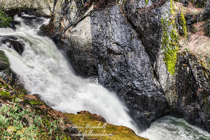
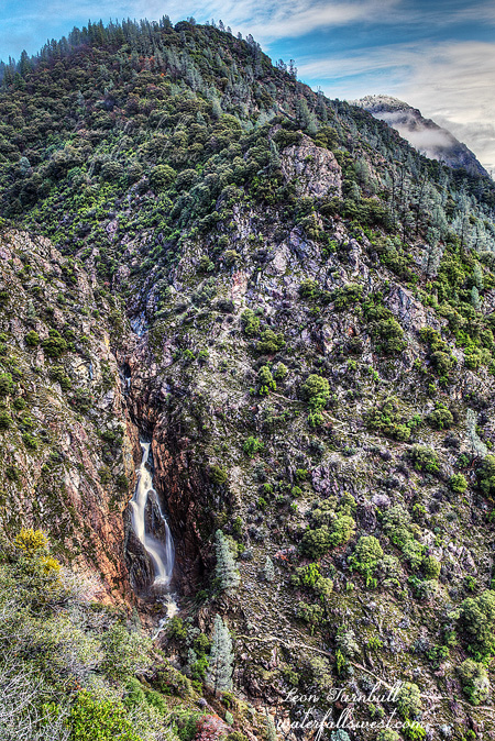
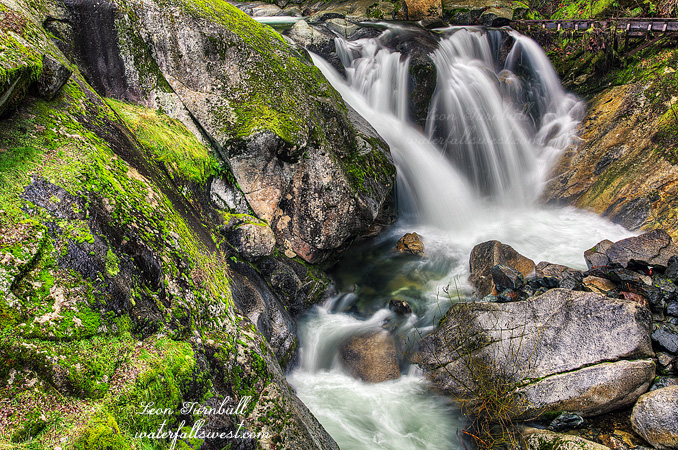
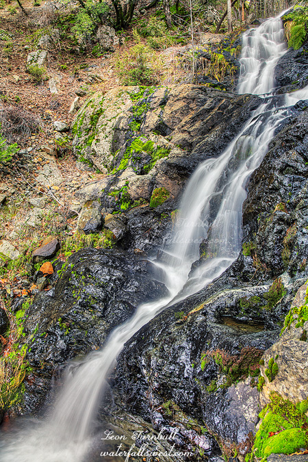
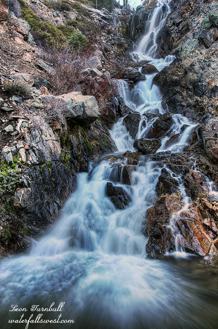
Serena Creek Falls is a gorgeous 80 ft. waterfall in multiple tiers. The surrounding landscape and rocky terrain and the waterfall itself were uncannily similar to Little Robinsons Valley Falls, which I was just at a month or so ago. There is a small upper falls, followed by a nice cascade, and then a gorgeous drop in a fan shaped falls. Exactly like Little Robinsons. Deja vu, again. It is obvious many people go down here, but it seems that only the locals know about this waterfall (before now). I had heard of Serena Creek Falls for the first time only last year. When I tried to come to it last spring, however, the creek was completely dry. It should have been fine, but the stupid drought nullified that. Well lets try again this January, and this time I had success. The big difference between this one and Little Robinsons however, is that there is a lower falls here. I did not know about this lower falls, and no one has previously documented this lower falls; I am the first to do so. I suspected there might be one, however, so after shooting the upper falls, I continued exploring downstream. Before long I came to the top of the lower falls, hidden behind the cliffs, but a path led down to the bottom where I found this beauty. I liked this one much better than the upper falls. It was completely gorgeous. Both waterfalls I measured to be exactly 80 ft. high. Go figure. It was an amazing and happy day at Soda Springs.

2 Comments

CRAZY

It’s a very very long drive out to Stirling City. I don’t often go there. Like I think maybe only once before. But I’ve been wanting to check out more waterfalls on Big Kimshew Creek and this seemed like a good weekend to do it. We’ve been dry for a few weeks now. Bad news. But I thought Big Kimshew would have water and it turned out to be more than I thought. The West Branch Feather River was hovering around 200 cfs all week (downstream of the confluence with Big Kimshew), so I estimated Big Kimshew might have about 50, but I think it was probably closer to 80 in actuality.

I had heard from the kayaking community that the road was now gated by Sierra Pacific. Permanently. If so, it would be illegal for them to do that, this is public forest land. Anyway I anticipated having to bike and was prepared to do that. Nine miles one way biking followed by a two mile hike. Total elevation gain would be around 3000 ft. It would not be pleasant.

I left my house at 4:30AM, and after the very very long drive (did I already say it was a long drive?), I arrived at the gated road at 7AM. By the way, when I stopped in Oroville at the gas station along the way, I saw a bunch of hunters all decked out in their gear getting ready to go out and shoot some things. One of them was Uncle Si. I’m not kidding you. He looked exactly like Uncle Si from Duck Dynasty. If he was not Uncle Si then he must have been a long lost twin. It was very weird. Anyway, onto my epic bike/hike.

I turned on my GPS when I got to Stirling City. Lo and behold, I realized that my map for this hike was not loaded into my GPS. This was an utter disaster! The waypoints for the waterfalls were loaded but my map did not get loaded. I distinctly and positively remember loading my map, so I have no idea how it did not get loaded into my GPS, but this was catastrophic. There is no way I could know where to go without a map, and yet, I could not just go home after that awful long drive (it was a horribly long drive to Stirling City, if you didn’t know). Hmmmm, well, upon much thought, I decided to continue. I had studied this route at home extensively, and I thought I would remember how and where I needed to go. It was worth a shot and better than going home with nada.

The sign at the gate seemed to indicate that the road was only closed during winter. I hope that is true because I am sure I will want to come back here, and not biking next time. The sign also seemed to indicate that the bridge over the West Branch Feather River was out. That could be a big problem, but fortunately it was not out. I did not want to be getting wet attempting to cross a raging river (well, not exactly raging but it would be wet). In nine miles, I gained 1300 ft. of elevation, and it was a tough climb. I was worried about my ribs, which I had injured hiking over the holidays. I have not been biking since then, and I was hoping the ribs would not complain about this big climb. Thankfully, they did not. Everything seemed to be going well as far as finding the correct route to take. I did miss one turnoff near the end and ended up biking an extra 100 ft. in elevation over a quarter mile, but I determined my error before too long, and went back to the correct turnoff, where I parked my bike. Now the hiking would begin. I had a total descent of 1200 ft. down to the waterfall. The first part was easy enough, along a logging road, but I had to eventually get off trail and hike down through the forest to the falls. Without a map, it was tricky to know exactly where to go. I came to an open area where I could see the falls in the distance. I had to traverse across the mountain side over to a ridge. I felt very odd. My knees were wobbly and the terrain was making me dizzy. It was not awfully steep, I have hiked steeper stuff, but it was steep enough that a fall could definitely cause serious injury, and I did not like it one bit. The terrain was freaking me out. Most of it was due to the bike ride, being that I was very tired from that big climb. But I think the wide open and steep terrain was also contributing to my state of being. Well, fortunately there was a lot of brush and stuff to hold onto, so I was able to make it over to the ridge. (on my way back up, I bypassed that traverse – I did not want to do that again). Things got a lot more brushy as I descended the ridge. I could not see the waterfall any longer, and without a map, I was not sure where exactly to go. When I thought I saw it through the trees, I exited the ridge and made my way down the steep terrain to the creek.

And there was the waterfall. Except that something was horribly amiss. The kayakers claim this waterfall is 50 ft. high. Well, I know they exaggerate heights and I was not expecting to find a 50 ft. falls, but this one was too small. It was less than 20 ft. high (17 ft. to be precise). Surely I was in the right location and this had to be the right waterfall. There was no other waterfall to be found. But then I looked closer. The main waterfall was actually above this little 17 footer, and hidden out of view behind a cliff, with no way to get over to it. I came down at the wrong spot! I was already completely spent and I still had a huge climb back out of the canyon but I could not leave without at least trying to get down to the main falls, so I had to climb all the way back up to the ridge, and then continue along the ridge and try to get back down at the proper spot. It was very tricky to find any view of Middle Big Kimshew Falls, but finally I was able to traverse along the cliff, and this is the best spot I could find. There was no way to get any better view of it, and even this spot was very scary to stand while I took this photo. Fortunately, my knees had stopped wobbling by now. I measured Middle Big Kimshew Falls to be 35 ft. high, much less than the 50 ft. the kayakers claim, but much better than 17 ft. also.

The hike down to the waterfall and back up the ridge took much longer than I expected it to take. I initially hoped to continue hiking down river, but I was already at my limit physically, and even if I wasn’t, I would have risked having to hike back in the dark if I were to continue any further. The bike ride back down the mountain was fast and awesome. The dirt road was very smooth and I was able to go very fast. When I got back to the bridge over the West Branch Feather, I still had 3.5 miles to go uphill (but thankfully, a very gentle uphill). Yet, as soon as I crossed the bridge and started back up hill, I got a severe leg cramp. I was in agony, I dropped the bike and laid down on the road for five minutes. This happens to me from time to time after huge hikes. Eating bananas help with the cramps, but I had no bananas with me. Well, after walking it off, I was able to get back on the bike, and continue up the hill without further incident. It was an awesome day in the wilds of Stirling City.

2 Comments

BUST

So some of you may wonder why I almost always hike alone. Well there are many reasons but here is one … Often I strike out on my hikes and do not find any waterfalls. It happens fairly often because I am usually hiking in places where people rarely (if ever) hike, and trying to find new waterfalls that very few people (if any) have ever been to before. I run into countless obstacles: confounding brush, raging rivers, impassable snow, death defying cliffs, crazy sasquatches, you name it. I would hate taking anyone on a hike and end up not getting to any waterfall for whatever reason. If they told me they didn’t mind I wouldn’t believe them. Even if I knew them and that they really didn’t mind I still would feel bad dragging someone out on a difficult hike and not finding any falls (and that has happened more than once). It’s better if I go by myself and do all the dirty work for you.

Take this past weekend as a good example: my initial plan was to go on a new hike somewhere up Foresthill Rd. The Tahoe NF website does not keep up with their road condition status very well at all but I thought maybe I’d be able to drive up there since there has not been all that much snow yet. I did not even make it to Mumford Bar before I encountered too much snow to continue. The big problem was that the road was completely ice, the temperature was about 20 degrees. There was no chance I’d get anywhere near I hoped to. Plan B was to try hiking down into Humbug Canyon where I thought there might be a waterfall. I was not certain but I figured there’d be at least a small one. I actually did not think I’d get even anywhere close to the creek. It just looked far too brushy on Google Earth. Worth a try though. As it turned out getting down to the creek was easy (well, as easy as a 1500 ft descent can be). I found a very old trail which pretty much went all the way down to the bottom. Was it an old mining trail? I think it must’ve been. At the bottom, however, all I found was a big cliff dropoff  and no waterfall. Not even a small one. There was perhaps a ten footer and a couple smaller cascades. That’s it. No way to get down all the way to the creek either without killing myself. No photos taken. It was definitely not worth killing oneself for a 10 foot waterfall.

Here is another shot of Canyon Creek Falls from last month. She’s a beauty.

1 Comment

BACK TO DRY

So you think we had a lot of precipitation in December, do you? I know the media was saying this before Christmas. Well, the official December tally from the NOAA indicates the truth: we are only at 45% of normal for our snowpack in the Southern/Central Sierra, and 55% for the northern Sierra. That is WAY BELOW average. We did have warmer precipitation earlier in December which did not add to the snow pack, but the overall precipitation was also below average and the rain did not do much of anything for our reservoirs. Folsom is currently at about 45% capacity, and Shasta/Oroville are 40% capacity, and this is also way below average. The worst part of all this is that we have been mostly dry for a couple weeks now and from what I have read the long range forecast for the rest of January is looking extremely bleak, barring a miracle (which I’m still hoping for). This will make it 8 out of the last 9 Januarys being dry months, and now we are seriously looking at the possibility of a fourth year in a row of far below average snow pack. But we still have February and March. Don’t give up hope yet.

This is 18 ft. high Fiddle Creek Falls, and it was still flowing quite strongly when I was here. A nice little falls right alongside the road. I would not have gone out of my way to stop here since I have been here before, but it was not out of my way, so thus I stopped! The flume at the top is interesting. When I was first here years ago, I thought it was just an ugly thing that needed to go away. Now I am torn. On the one hand, I wish it was not here, but the more I see of this waterfall, the more I think the flume is very much part of its character. It’s like the log across Lion Slide Falls or the ones at Russian Gulch Falls. Fiddle Creek Falls would just be naked without the flume there.

Comments Off on BACK TO DRY

SURPRISE

So here is my tally for the Christmas holidays of 2014: 5 hikes, 8 waterfalls (6 new ones, 1 old one, 1 sort-of-new one), 30 miles of hiking, 4000 ft. elevation of climbing (at least), one very bad case of poison oak, one injured rib cartilage. Not too shabby. The worst thing was the oak (ugh!). The best thing was Cherokee Creek Falls (see my last post).

This one, however, was a very pleasant surprise: Wet Ravine Falls, 33 ft. high. I found it right alongside the road as I was driving back down the hill from Cherokee Creek. I had no idea there was a waterfall here beforehand, but there it was, and for such a small creek, it was flowing quite nicely. Easy to get up close to, but a bit difficult to photograph.

I found it quite strange that some creeks in the Downieville area were flowing very strong, and others nearby had hardly any water in them at all. That was disappointing in some respects because I had hoped to get to see some more falls in the area that day. Wet Ravine was a nice surprise though, as I wouldn’t have thought this would be flowing at all. Sweet.

2 Comments