SILVER

I was so tired, I was not initially planning to stop here at the lower waterfall on South Silver Creek. I passed right by it, then 10 seconds later turned around and said “oh heck, I have to go down there”. It is not too difficult to get down, but I was just very tired, and I already had decent shots of this little 22 ft. high waterfall. Now I have another one.

When I was down there getting my camera ready to take pics, I dropped my polarizer, and I watched it ROLL about 20 ft. all the way down the granite slope and plop right into the creek. I just watched it roll. I could not run after it because the slope was extremely slippery. I thought it was a goner because the creek was rushing pretty fast, but it landed in a small hole in the creek. I made my way down the rocks carefully, as I did not want to be a goner myself. I got down on my stomach, and reached into the creek. I just barely had enough arm length to reach the filter. Whew. Another maddening adventure in the life of the waterfall madman.


No Comments

THE NEW BASSI

I have been trying to get to Upper Bassi Falls for three years now. I finally got it. It is a tough one indeed! But I now bring you this exclusive new waterfall that has never been documented before by anyone else.

How do I even know about all these waterfalls anyway, you ask? I study topo maps. I study Google Earth. I find likely candidates. I search them out. More often than not, unsuccessfully. You cannot see anything on Google Earth for this location, but the topo map indicates a substantial drop here. It was going to be an epic waterfall. But could I even get to it? Finding an upper waterfall on Bassi Creek has been my dream for some time. It is almost as though I willed this waterfall to exist.

Two years ago, I made my first attempt. It seemed logical to me to make an attempt at this waterfall from the side or from above, since there is a well traveled trail. From there you are pretty close to Bassi Creek. And yet so far. However, the trail up to the top was much more difficult than I imagined, and took a very long time. There was also too much snow, so I did not venture over to Bassi Creek. Last year, I tried again. I biked as far as I could, in order to save time and make the hike quicker. Biking did not really save too much time (though coming back down was a bit quicker). I climbed up a ridge  to make my way down to Bassi Creek from above. However, the manzanita brush there is incredible. It is about two stories tall. No way to get through that stuff. I tried a second time that year, thinking I could come over to Bassi Creek from the side. Again, far too much manzanita.

This year rolls around, and I decide to make one last attempt at Upper Bassi Falls. This time I will hike in from below, following Bassi Creek up to the waterfall. I did not really have much hope. It seemed pretty darn brushy on Google Earth, in particular the last half mile or so. Well I thought, maybe if I could get within a half mile, I can just pound my way through that brush. And so I did.

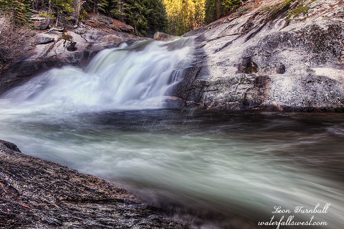
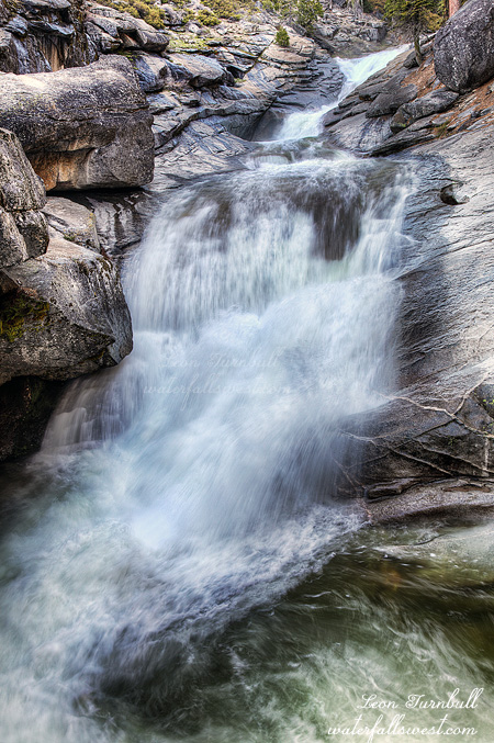
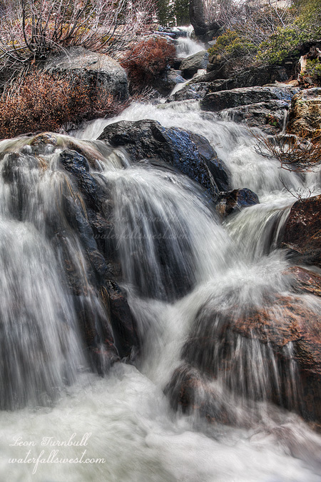
The trailhead starts out at 6500 ft. I thought there might still be too much snow at 6500 ft., and in fact I wondered if I could even drive to the trailhead, but there was no snow at all. Indeed, there was hardly any snow on the entire hike up to the falls. This is very sad when you think about it. It is only May 10. The trail starts out very nicely. Most of the hike was actually quite fun. I was having a grand old time. Until I came to that darn brush. Then it was NOT FUN. It was pretty easy to follow along Bassi Creek at first. Like I said, I was having balls of fun. About 0.5 to 0.75 miles before the falls, however, it starts to get steeper, and then the brush comes at you. You can try to duck, it will smack you. You can try to jump, it will smack you. You can try to deke your way around it, but it will smack you. Seriously though, there was just one small section with this incredibly thick manzanita, near the bottom of a small waterfall. I thought if I can get through this brush to the top of this section, then the terrain will level out and it might open up. It was close. So close. The manzanita almost claimed victory, but I found a way through that brush and up to the top of that small waterfall. And voila, the terrain did open up. I was able to continue following the creek up to the waterfall without too much difficulty. Where there should be a massive waterfall. But alas, where I only found this 47 ft. high cascade. It was not the epic waterfall that I envisioned being here. C’est la vie. There is a large drop in elevation here, perhaps 150 to 200 feet in total, however, there are no substantial falls. The creek just cascades very uninterestingly down this part. This 47 ft. section was the only one that I would consider to be an actual waterfall. But still, it is a nice little cascade for sure.

The sun was a killer for me. According to my calculations, I had until 11:30AM before the sun would be on the waterfall. I figured I had plenty of time to get up here and thus I did not rush. However, when I arrived at about 8AM, it was already in the sun. What? How did I miscalculate that one? The sun was shining right in my face and right on the falls. Not a good thing for photography! The weather forecast had indicated it would be all sunny in the morning, and the clouds would not come in until the afternoon. Well, God is good and He provided a miracle for me, bringing in some clouds to cover the sun so I could take some decent photos of this waterfall. Thank you Lord. Awesome!

I continued to the very top of the waterfall and then upstream for another half mile. I thought there might be another waterfall possibility further upstream, and even though I was tired, I knew I will likely never be back here so I just had to check it out now. At the top of the falls, I finally hit the snow, and it was flatter, so hiking that half mile over the snow was pretty easy. However, there was no other waterfall up there. Ah well, at least I tried.


6 Comments

ICE HOUSE

I am finding it more and more difficult to find new waterfalls. This past weekend saw my fourth strikeout in a row. There is a good reason for this: if it is a new waterfall that no one knows about or has been to, then by definition it will be almost impossible if not impossible to get to; otherwise, many people will have been there before!

This weekend the hike started out pretty good, but soon ended in a mass of steepness and brush. It was supposed to be an easy 2 hour hike to the waterfall, but after two hours had passed I was still at least a mile, a few hundred feet in elevation, and a tough river crossing away from the destination. I had to turn back. The nice thing is I was not too far away from Ice House Reservoir and South Silver Creek, and there was still enough time left in the day to get there.

As I drove to the end of Ice House Reservoir, I encountered an enormous mud puddle. I debated about proceeding through it with my SUV, but it looked just a tad too big for my beast to handle. I was planning to walk the rest of the way, but there was another guy there and he encouraged me enough to go for it. It is rather interesting that he decided to NOT proceed through the mud with his truck (which seemed more up to the task than my SUV), but he was certain that I could make it (or he just wanted some entertainment to see me get stuck). Well, I decided to take his advice to heart and I went for it. As it turned out, it was fairly easy to make it through the mud, and I continued to drive to the end of the road without any more major obstacles.

I ate my dinner sandwich, and then started up the trail to South Silver Creek Falls. It is only a half mile and a pretty easy hike, but I was extremely tired from the first hike, and I struggled. Nonetheless, I was determined to make it to a waterfall today. The creek was flowing quite well from snow melt, but for how much longer? Peak water flow is long gone, most snow has already melted, and I suspect that in 2 or 3 weeks, this creek and many others will be reduced to summer time flows. I was a little braver this time at South Silver Creek Falls, setting up my tripod on the very edge of the rock ledge, and so this time I got a clear camera angle and view of the magnificent waterfall, and one that I have not shot before. I suspect that I was braver this time because the rocks were all dry and the footing was firm. The last couple times I was here I think the rocks have been wet, which makes the precipice extremely dicey and slippery. You certainly would not want to fall from here.

Well it was getting late by now, and time to get back to the car, through that giant mud puddle, and drive back home. It was a very pleasant afternoon in the Northern Sierra.

No Comments

O-FER

This past weekend was quite a disappointment. I ended up being zero for four in search of new waterfalls. I went first up Foresthill Rd and ran into too much snow to continue. I tried a second location and also came across too much snow. I then went back to Foresthill and up Mosquito Ridge Rd, trying a different route to Peavine Creek Falls. This time I ran into too much brush to continue on. I went to Grouse Falls next, which is easy and does not count (it is not a new waterfall anyway). After that I tried to find another new one in the area, and again ran into too much brush. So all in all, it was an ofer weekend, and rather disappointing.

On the plus side, this last little storm we just had at the end of April was pretty sweet, dumping a couple feet of snow in the Sierra. Maybe it will extend waterfall season a couple weeks, but most of the snow had already melted before this storm, so it is still not going to be a very good spring. Will we get any more rain in May? Pretty please.

Grouse Falls was definitely flowing pretty nice this weekend, and the road was all clear from any snow, since it is at a lower elevation. Grouse Falls is always a great waterfall to visit in the spring, but it is such a long drive out there. I don’t think I will be back on Mosquito Ridge Rd this year.

Here’s the newest vid from Waterfall Madman – from Lassen Volcanic National Park, West Sulphur Crk Falls. Please watch in HD. Thanks!

No Comments

MAD

I found this 25 ft. waterfall in Mad Canyon right beside the road. Getting up close to it was completely maddening! The poison oak was absolutely nightmarish! It was so bad I decided to come back the following week with my clippers, and tried to clip away all the oak as I scrambled up through the brush to the falls. I don’t think it worked because I still got the itch afterwards.

It was not even worth all that trouble anyway, the waterfall is not very photogenic and not very big. It looked a lot bigger from the road.

9 Comments