HIDDEN

Many years ago someone told me about a waterfall on the North Fork Cosumnes River, but he was extremely vague about its location. Nonetheless, at that time, I went down to explore the area where he had told me to go, and searched the river up and down and found nothing, except for a 5 foot high falls. I figured that was all she wrote, as has happened often before when people tell me about waterfalls which are not waterfalls at all. A 5 foot drop is not a waterfall people! Indeed, my wife just recently showed me a picture of a little so-called waterfall where she took a photo of our daughter. It is a beautiful photo, but it is not a waterfall! Yet she insisted it was.

Well, fast forward to this summer. As I explored Google Earth during the off season, as I always do, I discovered what seemed to be a potentially big waterfall drop on the same river. I decided to check it out. This would be a scouting mission for the spring, because I was not expecting the waterfall to be flowing too much in mid October. As it happens, it was very close to where my friend had told me about many years before. Could this be what he was referring to after all? I suppose it is possible, but I am thinking not. This waterfall was extremely well hidden, with very difficult and cliffy access. It was no cakewalk, and I saw no evidence that people were ever down here before. I only saw a bear trail along the cliff side (and why they would be going down here, I have absolutely no idea).

I tried to get here last week but failed miserably. It was pretty easy to get to the top of the waterfall, but you cannot view the falls from there. I tried to get to the bottom, but there was no way. There was a cliff ledge on the other side of the river across from the falls. If I could get there, then maybe, just maybe, I could view the waterfall, but crossing the river at the top of the falls was not an option. It was not because of the flow in the river, but because of the cliffs on the other side. This is one crazy location. The waterfall is tucked in between these cliffs on both sides of the river, and it was not going to give up its views very easily. The only possibility I saw was to approach it from the top, on the other side. I would have to come back another day to try that, but I did not have much hope. It looked extremely steep and cliffy.

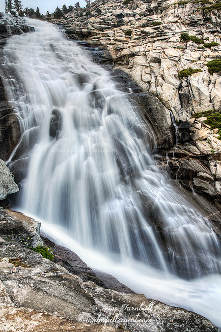
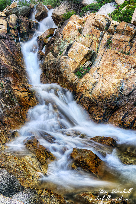
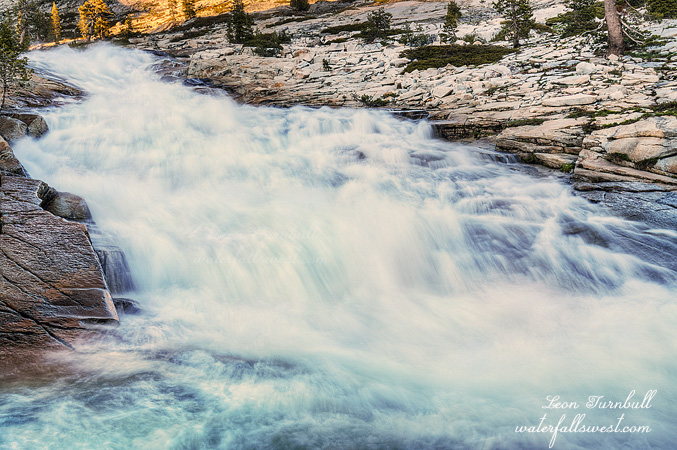
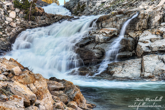
I tried again the next week. No surprise, the descent from the other side was crazy steep. The drop-offs were severe. The waterfall, as I said, is extremely well hidden, especially from this other side. You cannot see the falls, or even see where it is located. I could not see the cliff ledge that I wanted to get to either, as it is also hidden. I definitely did not want to approach the river above or below the waterfall because I would be cliffed out and then have to backtrack. As I got closer to the river, I finally saw some clues to where I should be, and then finally got a view of that hidden ledge. I used my rope to be safe, and lo and behold, and shockingly, I found a way down onto that cliff ledge. From there, I was looking down on the waterfall, and I could see the entire drop, a beautiful 47 ft. high falls in two tiers. I was standing on the very edge of the cliff to get this view. What a sweet view. Now THIS is a waterfall. I will definitely be returning here in the spring when the river is much higher.


No Comments

OVERCOME

It is summer. Hot, muggy, mosquitoes, and now smoke from fires. It must be California.

It also means it is time for my annual trip to Horsetail Falls. Horsetail is the only waterfall around here that flows well late in the summer. There are not many mosquitoes here either. And it was warm but not overly hot up in the mountains. That just leaves the smoke, but surprisingly, when I arrived at the trail head it was not that smoky at all. There was a bit of haze but not too bad at all.

It was Friday. I left after work. The traffic was horrendous. There was a truck along the highway that was completely incinerated. Traffic was backed up for miles. Fortunately, the firefighters got the fire out. This is somewhat similar to how the Carr fire got started. I almost turned back because of the traffic but I continued on.

So I arrived at the trail head later than I hoped, but I did not rush on the hike because I was taking a video along the way. There was no one on the trail, which is the nice thing about coming on Friday evening. I got up to the bottom of the lower Falls at about 6:45. The waterfall was flowing quite a bit better than I expected it to be. I took some quick photos and decided how I would accomplish my next feat.

I have been up to the top of Horsetail Falls a number of times of course, but the last two or three times I have had to turn back. There is one very steep and slick section just above the lower waterfall. It is freaky. I think that in my old age it has just psyched me out too much. All you young bucks have no trouble I’m sure. Anyhow, this time around I managed to squeeze and squeeze and wedge myself up through a crack to get on top of the ledge above the slick granite. I made it! I was in shock because I was not expecting to make it up. I wondered what I should do next. This was a big major mental obstacle for me to overcome. Now I am confident I can do the same thing again in the future. I was feeling ecstatic.

The thing I wanted to do next is get over to the bottom of the upper tier of Horsetail Falls. I have never been to the spot before and have wanted to do it for quite a while. Once above that slick ledge, it was pretty easy-going. There were a few big rocks to walk over and some brush to go through but I made it over to the base of the huge cascade. So Awesome!

It was now very late in the day. I had very little time to take photos and video and get back down the mountain, and I did not want to go back down that ledge in the dark. Thus I did not spend much time here at the upper tier, not nearly as much as I wanted to, but I took my photos and left. Going down that ledge is much easier than going up.

It was after sunset when I got to the bottom of the lower Falls. I still had to hike down to the trail head which is another 45 minutes. The entire hike was in the dark. But I did not mind, I had my headlamp, and it was an awesome experience at the Falls today.

Even with my headlamp, it was very difficult to make out the trail because there were particles in the air making it hard to see. I don’t know if it was just dust, or smoke particles. I think it was the latter, but as I said the smoke was not bad at all. Thus it was not surprising when I tripped over a root (or ruut as Americans “think” that Canadians say) and landed in the dirt. No harm done, just a dirty leg. All in all, totally worth it for this short hike to Horsetail Falls in the Desolation Wilderness.


No Comments

MARMOTS AND MOUNTAIN TOPS

I am not one who normally likes to climb mountain peaks. Before this past week, I can only think of one mountain I have climbed in the past few years. I will climb up mountains, with or without a trail, with or without cliffs, in order to get to a waterfall. But waterfalls do not exist at the very top of mountains. Right? So what is the point in climbing a mountain? It is too much hard work!

Nonetheless, on July 4, I had a stupendously great idea: climb to the top of Pyramid Peak. At 9983 ft., it is the highest mountain in the Desolation Wilderness, and third highest in the Lake Tahoe area. Along the way, I would stop at a new waterfall that I had not seen before. It was going to be an epic day!

It is not an easy hike to the top of Pyramid Peak. There is no defined trail, and I would be going the long way up. There are three main “routes” to the top (no “trails”). The one I chose was the longest route, 6.1 miles, but also the easiest (supposedly), with the least amount of elevation gain (3300 ft. in total). The main reason I chose this route was because of the waterfall.

I started hiking before sunrise. I wanted to get to that waterfall first, before the sun. It was almost five miles to the falls. I hiked quickly. Thankfully, these five miles are somewhat tame in elevation gain (and this first 5 miles was also on a defined trail). The hard part would come later.

Along the way, I came across a bear. It was the first bear I have seen this year! Considering that I have backpacked in a number of wilderness areas this year, including the bear haven of Yosemite National Park, it is surprising I have not seen any bears yet. Technically, I was not even in the wilderness yet when I saw this one. But I was happy! A great start to my epic day. I got within 20 feet of the bear before either of us saw each other. Then he took off like a scalded cat. I only saw his big brown behind.

I came to the waterfall just a little before the sun. Not really a great waterfall but it was pretty and it was over the minimum 20 ft. high. I took some photos then psyched myself up for the upcoming tough part of the hike. I still had 2000 more feet to climb in about a mile. In case you are wondering, that is a lot!

From Lake Sylvia, there is, supposedly, an obvious notch that you need to climb up to get up on the ridge leading up to Pyramid Peak. It is, supposedly, not very difficult to climb up. I could see the notch. It looked horrifically steep and cliffy! Well, I worked my way over to the bottom of it. I could see a path going up a secondary notch. This must be the correct way. People have obviously gone up here before. The other notch would be far too cliffy. I started up. Before long, however, the path became incredibly steep, crumbly, and dangerous. But this must be the correct way! I hemmed and hawed for a long time, then decided to turn around and go back. It was too steep. A fall here could easily result in broken bones, if nothing worse. So now what? Do I go back home?

Before doing that, I decided to go over to the other notch, although I was sure it would be far worse. However, when I got over to it, I saw a well defined path going up the mountain. This was the proper trail! It was not too steep or dangerous. It was pretty easy (except that you are climbing up a mountain with lots of elevation gain). I got up to the ridge in short order. Now I just to climb up the ridge to the top. There was still 1400 ft. of elevation gain to go, now much less than a mile. It was very slow and took a long time. The last section was a jumble of huge rocks that you needed to climb up. I found it very fascinating, obviously volcanic in origin, but it was not easy to climb up (or down). However, the marmots sure must love all these rocks. There were a lot of them around, especially at the top. I got lots of video of them ( so watch for my upcoming video of this hike).

I was not the first one to the peak. In fact, there were a lot of other people climbing up Pyramid Peak on July 4. No doubt because it was a holiday, this was the reason. I would have liked to have some alone time on the peak for a while. If I had not messed around for 45 minutes trying to climb up that other notch, I would have been the first to the top. Ugh. Oh well. I took my time at the top, had my lunch with the marmots, and of course took some photos. There was a lot of haze from the fires in California (one big fire, anyway). I could see Lake Tahoe, barely, off in the distance through the haze.

A trio of East Indian guys came up while I was eating. It was a bit funny because they totally freaked out when they saw the marmots. They thought they were skunks, or some other dangerous animal. I reassured them that marmots were harmless, but just keep an eye on their food. Ha! After saying that, one of the marmots jumped on one of the guys’ head. Kidding! But seriously, did I ever tell you about the marmot that tried to kill my daughter when she was a baby? A story for another time. (ok, it did not actually try to “kill” her, exactly).

Well, time to go back down the mountain. It was a long 6 miles back to the car. The steep part down to Lake Sylvia I found to be very hard on my knees, but after that it  was a nice gentle downhill. Except that I ran out of water three miles from the car. I had brought 3 liters, but it was all gone. I could have filled up in the creek in an emergency, but decided to just get back to the car as soon as possible, where I had plenty of water waiting for me. I was very tired when I got back to the car. Hopefully, I would sleep well that night, but it would be difficult with all the fireworks going off on our street. I still had to go to work the next day too, but it was an epic day in the Desolation Wilderness.


No Comments

DAY 3. WELCOME TO THE JUNGLE

We had no mosquitoes (or very few) in West Cherry Creek Canyon. I think we hit this area at the perfect time. Everything was about to change.

We woke up fairly early, had our breakfast, and packed up camp. We had about 9 miles to hike. The temperature had skyrocketed. It would be a hot day hiking back to the trailhead, and it was best to do it in the morning.

We had one visitor at our campsite in the morning, a marmot. He was hanging out on a log by our tent, not paying much attention to us, and drinking my pee. Well actually, I think he was eating ants on the log, but it was the same place where I had been peeing. Flavored protein?

In the two days we were there, we saw no one else in West Cherry Creek Canyon. We had it all to ourselves. That is another reason it was so awesome. Being all alone in the wilderness, with no other human being within miles of you, I find that so refreshing. All that would change on the hike back, however. We saw tons of other day hikers and backpackers on the trail, on the last half of the hike especially. It was ridiculous. Most of them were not going to West Cherry Creek, likely, but still it was crazy busy.

Another thing: mosquitoes! We came to the Piute Creek crossing and all of a sudden, the mosquitoes were a force to be reckoned with. Up to that point, none. Piute Creek and from there to the end of the hike, they were all over the place. There was one backpacker we saw at Piute Creek, who said he had camped there that night, and was eaten alive. Half his arm was missing. I told him to go to West Cherry Creek. There were no buggers there. I think he was going to do it. After he applied the necessary first aid to re-attach what was left of his arm.

Five hours after we started, we arrived at the trailhead. It was hot. We were tired. But we made it. We had a glorious 3 days in West Cherry Creek Canyon. (I did, anyway).

No Comments

DAY 2. CHERRY ON TOP

There was no sun at our camp in the morning. It would take awhile for the sun to penetrate those granite walls. Thus, it was very cold in the morning. We took our time eating breakfast, and packing up our camp.

It would be an easy day. We only had to hike 3 miles back to the top of the canyon. Jadon should have been much happier today. He was not. Not that he complained, but he was not enjoying himself. He was probably bored too. We got to camp before noon, then had nothing to do all afternoon, so we napped and played cards.

At around noon, I tried crossing West Cherry Creek (while Jadon waited in camp). You would think it would be utterly impossible. The inflow to Cherry Lake was about 700 cfs. West Cherry gets about half that flow, so 350 cfs. That is certainly not crossable, but right at the trail crossing, the creek splits into five separate channels, so about 70 each? But at noon, it is much less than that as well. So in other words, I crossed the creek easily. It was up to my knees, and there was a strong pull, and it was freezing cold, but it was crossable. I explored the other side of the creek, and I came up with a plan for the evening. It was a darn good plan, but sometimes plans go awry.

You see, I was 90 percent sure that we could not get to the upper falls on the near side of the creek (where we were camped). There is a granite cliff that comes down from Piute Lake right to the creek, and the main part of the waterfall is around the corner, out of sight. I was certain we would not be able to get around that corner. However, on the other side of the creek, as I explored, I could see the upper falls, and it looked easy to get up to see it. So the plan was to cross the creek in the evening, and go up to the falls on the other side.

However, one problem: in the five hours since I crossed the creek at noon, the creek level had now risen by about one foot (perhaps a bit less) due to snow melt from the heat of the day, and it was now uncrossable! It was crazy how much it had risen, and it was far too risky to cross it now. I figured I could just try it again in the morning. We decided to climb up the creek on this side and see how far we could get. Well as it turned out, this was a better plan anyway! Getting around the corner was actually very easy, and we came up to the main section of the falls, a majestic two tiered waterfall about 70 ft. high. It was a glorious spot (and much better than it would have been on the other side of the creek). I was very happy, and I would not have to cross the creek in the morning. Sleeping in was a much better option now. Yeah, now that is a good plan.

No Comments