DAY 3. WHERE THE BEARS ROAM

It was a very cold night, much colder than the first night. I’m sure it was below 32 degrees. The little streams and puddles were all frozen in the morning. I survived. I was wrapped up in all the clothes I brought with me and snuggled deep in my bag.

After breakfast I packed up and headed up the mountain. I thought I made great time. I was following my tracks in the snow from the previous day and it was quite easy. Yet it still took two hours to climb to the top (3 miles, and only about 800 feet ). Really!?!? It should not have taken so long. Where did the time go? I wondered how long did it take me to go down to the bottom the day before because surely it was much longer.

I saw many animal tracks in the snow. All fresh. Coyote. Deer. Mountain Lion. On Styx pass, I saw a lot of big cat tracks . He must live up there. It figures that is where the Lion would live. In Hell. I did not see him though.

I did see a truckload of bear tracks, more so than any other animal. They were all over the place, even at my campsite (not a place you want to see bear tracks). I wondered if I would see one. They can’t be too far off, some of these tracks are very fresh. Indeed, as I descended down the gully (off trail) to my next campsite, in fact I did see one. A big brown colored bear. A grizzly bear. No, not a grizzly bear. There are none of those in California, but it was a big brown one. He was right in my path just wandering about in the middle of the day. I gave him a wide berth and thus ended up going through more brush than I desired, but better that than bumping into the big guy.

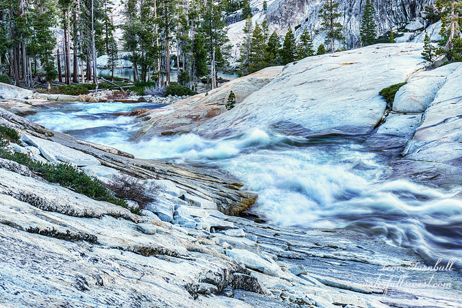
There is a lot of brush on this big 1500 ft descent, especially in one particular cliffy area. It was not anything short of awful. I came close to turning around but kept on. After getting through the brush, I had to descend straight down a creek bed at one point, going down steep scary granite at another. I finally got to the bottom.

Spectacular!

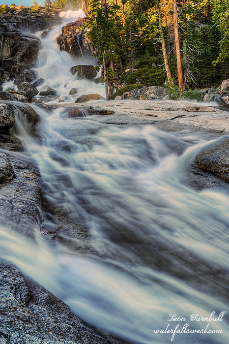
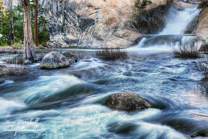
The campsite is right at the bottom of a stunning 50 ft waterfall. It doesn’t get any better than this.
I think the site is called the Flintstones due to rock tables and chairs in the camping area supposedly, but I did not see this. I was not impressed by the reasoning around the name of the place but anyway, it is an awesome spot.

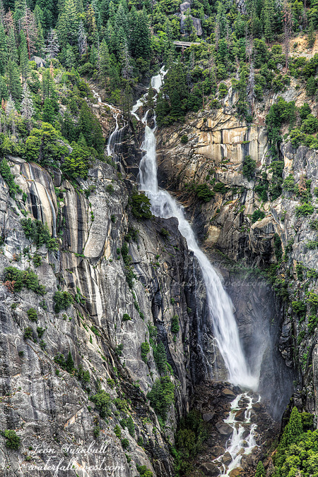
After dinner I tried to get up to Cherry Bomb Falls but I could not do it. I thought it would be easy, but I could see no way to get up above the ridge in order to get to the Cherry Bomb Falls. Others have done it but how? Did they cross the river? It would seem to be the only possible way to get up, and I do think the proper route is to cross the river, but clearly that was not possible on this day.  I was bummed. This was the main reason I came down here, to see this particular waterfall.

Will I try another year? Perhaps but I just don’t know at this point. It is a bit beyond my comfort zone. At least I found a couple nice waterfalls down here, including this beauty at the campsite. It was not a big loss at all.


No Comments

DAY 2. THE ROAD TO PARADISE

The road at Cherry Lake dam was closed due to storm damage from the winter. This would add 4.5 miles to my hike one way, and not a very easy four miles either. I heard one of the workers say they were all done with the road fixes, so if I had come a week later it would probably be open and I’d save myself 9 miles of tough hiking. One problem with that: it was supposed to be 100 degrees the next weekend. Not this day though. It would be close to freezing temperatures that night, and indeed it got down to 35 degrees as I slept in my vehicle at the trail head. It was cold. It would be even colder the second night. I just hoped I had brought enough warm clothes for the backpacking trip.

It was so cold in the morning that my phone battery was dead as well as the battery in my solar charger. I could not send any signals to my wife letting her know I was ok. This was a disaster! I thought I’d have to turn back before I even got anywhere. She would be totally freaked out if I was not sending any signals to her for three days. I decided to continue on for an hour and try again after warming the phone and charger against my body. It worked. I told her not to worry if she was not getting any signals from me. I felt relieved and she would now be relieved (well, somewhat relieved).

It was not supposed to rain in the morning. It was raining. As I climbed higher it turned to snow.
I didn’t think it would get any better all day. In fact, the weather was supposed to get worse in the afternoon. I needed to stay dry, it was going to be a cold night.

My goal was Lord Meadow, a 16 mile hike one way. It’s nice that the Lord has some cool place named after him. It seems the Devil has more such places. It should not be that way. I did have to hike through an area called Styx Pass, however. There is no river running through it (as you might think from the name), but it sure was hell hiking through it. It took forever! Swamps, fallen trees, brush, snow. I could not find the trail most of the time due to snow cover. There was snow from 7600 feet all the way to the top (7900) , then all the way down the other side right to Cherry Creek. It was especially hard with the fresh snow on top of the old. I could not see what I was walking on, and if it was stable or not. There was one very treacherous descent on the snow on the other side. In a normal situation I might have balked, but I couldn’t turn back now. I was so close! Fortunately the snow was hard packed and I got down it safely.

Lord Meadow was incredibly beautiful. Cherry Creek was big and wide. It was 4pm when I arrived and I was dog tired. Styx Pass took a lot out of me. Hasn’t someone said before that you must go through Hell before you can get to Paradise?

After setting up camp by the Creek I hiked up stream a ways to a waterfall on the East Fork Cherry Creek. By now the sun was out. I waited a long time but did not get any decent light so I had to hike back. Then I went down stream to Upper Cherry Creek Falls. I could not get down to the bottom of it (as I expected). It is too treacherous on the south side and impossible to cross to the north side of the creek. I did manage to get a shot from above the Falls looking down on it. Not too bad (I did not think I’d get any shot of it). It’s a very nice 50 ft slide. I suppose you might think it is a stretch to call this a waterfall. Perhaps, but the angle from above makes it look less than it is. It certainly would have been nicer to get to the bottom of it. To do that would have been pure stupidity.

A couple people asked me about crossing Cherry Creek as if it is obvious I’d do that. I’ve heard of hikers making very dangerous crossings at various places this year already. Such as one guy crossing a swift river above a 60 ft waterfall on the PCT, and losing all his gear (and almost his life) when he slipped. What? I don’t understand stuff like that. You’d have to be nuts to cross Cherry Creek. It was huge. The water would be up to my neck (most likely) or worse, and swift flowing. Why risk dying? I had no intention of crossing even before I started the hike. I knew it would be uncross-able. It’s not worth it to get a better photo of a waterfall. And anyway, I like this photo. Stay alive. It’s a good motto.


No Comments

DAY 1. ZOO STATION

My latest 3 day backpacking trip would take me to Yosemite, just outside the park actually, but the first day it was supposed to rain all day so I just wanted to do one fairly easy hike in the morning before it all started. I went into the zoo, I mean the park. At the trailhead, I went to put my food in the bear lockers, but they were absolutely disgusting. Garbage totally reeking inside them. It seemed like they hadn’t been cleaned out in years (I’m not exaggerating). Seriously, park officials? You want us to secure our food from bears, but you do not provide any decent clean place for us to do this. Well, I just left my food in the car in my cooler and hoped for the best. It was not going to be a long hike. My hike was a bust, I got to the top of a waterfall but could not get down for a view of it. No wonder I’ve never seen any good photos of this one before, I thought for sure I’d get something here. I was bummed.

I went over to The Cascades. Someone recently shared a good photo of this one from a view point I hadn’t known about before and I wanted to check it out myself. You can actually get down right across from The Cascades, it is an amazing view of this waterfall, and you can see the entire section of the Falls below the bridge. It might be a bit tricky and slick if it’s raining though (did I say it was raining?). Nonetheless, despite the wetness, I did get right down to it.

Interestingly, as I was photographing the waterfall I saw some kids coming back up. One of them was telling his friend to jump across this certain gap. He jumped and he missed and he fell into a hole. From my vantage I could not tell if it was a five foot hole or a fifty foot hole. I just saw him completely disappear and heard his friend shout an expletive. Was he dead? It turned out to be less than five feet and he was not hurt (too much anyway, I guess). Dang people. Be careful out there.

After this I went into the valley but it was a zoo and I could not find any place to park, and then it started pouring rain. I did not take any photos except one of Bridalveil Falls. I drove out of the valley and back to Groveland for lunch trying to get some carbs in me for tomorrow. Then the sun came out. It was supposed to be raining all day! I didn’t know if this was a good or bad sign for my trip starting the next day.

We shall find out soon….


No Comments

THE LADY AND THE TRAMP

I was hoping to drive up to Robinsons Flat and camp on Friday evening. Remember, the guy I talked to last week said that they had gone up there the back way via Mosquito Ridge road. It seemed unlikely to me, that road is higher elevation. Yet they said there was only a few snow patches that way. It seemed promising, so I had to try it. Well I hit 6200 feet, and ran into a big huge snow patch, an impassable one, not a small one for sure. What? How could anyone drive by this? I saw no evidence that anyone had driven any further. Perhaps they had a big jeep and got by, but there is no way I could drive by in my SUV. Even if I could, there would still be another 700 feet to climb with more and bigger snow patches. I had to turn around.

Well, I had back up plans and other ideas in place, but I really really really had my heart set on hiking from Robinsons Flat and I did not feel like doing anything else. So I started to drive back to Foresthill, still pondering if I should drive home or drive somewhere else.

That is when I came across the lady. Perhaps I will call her the tramp for the sake of this story. It was almost dark, she was walking down Mosquito Ridge Rd by herself, out in the middle of nowhere. She was walking all the way to Foresthill, essentially from near Grouse Falls. That is a 20 mile hike, and she had only walked about 5 miles or less thus far, and don’t forget the last 10 miles is a steep uphill and she would be hiking up this in the dark. She was a scary looking lady, dressed like a vagabond, tattoos, playing horrendous rap music on her phone, carrying a spear (to ward off animals she said), and also carrying a hatchet (I did not see this, and I think I’m grateful). I rolled down my window and asked her if she needed help. She said she would be very grateful for a ride into town. She was actually a very nice tramp (er … lady),  despite the attire, obviously not wealthy, and she said her truck had been repossessed and she had to go back to Foresthill to claim it again. She lived up on the mountain.  A hermit, though she called herself a hippy. Well of course when I told the story to my wife later, she was aghast. She could have been an axe murderer! Or just escaped from prison! She did not believe that the lady could be telling the truth about walking back to Foresthill to get her truck. But for me, I had a good feeling that she was legit and really needed help, so I was not apprehensive about giving her a ride. It was certainly an interesting encounter on the wild side.

Anyhow, fast forward to Saturday afternoon. My wife, who is working as a pet sitter in Folsom (do you need someone to pet sit your animal? Call Tara Turnbull! 916-337-4695), she had a few hours with one of her dogs to spend. She wanted to take the dog somewhere cool, not hot, and not have to pay $100 (or something) for parking at the lake. She wanted suggestions from me, and she wanted me to come with her. Well if you want me to come with you, then we must go to a waterfall. She said OK. I said how about Bassi Falls? She said OK again.

So we picked up the dog, and drove up the hill. It is a very easy 2 mile hike to the waterfall. We only had the little car, so we could not drive to the normal trailhead. The dog had a blast. It was her (the dog’s, not Tara’s!) first time seeing a waterfall and a rushing creek. Getting into the creek was not an option, despite how much the dog may have wanted to do so. Bassi Falls, she was raging! Now Bassi is a true lady, and today the lady was in fullest form, at her absolute best.

I have heard some people say recently that peak snowmelt has still not yet happened at this creek and others in Northern California (Bassi Falls in particular). I assure you, however, that peak snow melt is long past at Bassi Creek and in the Northern Sierra , and that happened about a month ago on May 5). That may not be the case in the central and southern Sierra, it usually happens later there, and some of those rivers have not reached peak yet. However, in the Northern Sierra peak is well passed. There are two big differences this year, however. First, there is still a large snow pack, and the strong flow is continuing this year for a much longer period of time, and will continue for another month if not longer. Second, the peak flow this year (and also the current flow), is much higher than the peak flow of the last five years.

I have been to Bassi Falls many times. I am 99% certain that I have never seen it flowing this strong before. A full month after the peak flow! I know this because I could not get up as close to the Falls as I usually can (certainly not without much difficulty anyway). The little streams you can usually easily wade across had a very strong pull, I had to be extremely careful getting in the water this time. One slip and I would be gone. Back to Folsom Lake the fast way. Also, I was able to find new compositions that I have never seen before. For instance, I have never seen water flowing down this little channel before, and it was such a good little stream, it made for a great foreground. It was quite fascinating.

We stayed for the good light. Then we hiked back, arriving at the car just before dark. It was great to see the lady again, especially after missing out Friday night on what I had wanted to do.


No Comments

DAY 3. THE LITTLE ONE

It may be little compared to its neighbors but it is no inconsequential waterfall.

I wanted to get up early and go on another hike but I could not sleep at all. I was not even tired. I should have been tired! It was well after midnight and I still could not sleep. I don’t have any idea why. I was comfortable in my tent. I had a good hike the previous day. Why can’t I sleep! I turned off the alarm and slept in as much as I could. Then I just relaxed at the campsite in the morning, with coffee and breakfast. It was a beautiful morning down in New York Canyon.

I did find this one new surprise waterfall. It is in close proximity to massive New York Canyon Falls and the other big Falls on this Creek, so you might think this one should be left out and dismissed. It should not be dismissed! It is a very lovely 25 ft high waterfall. I could not get down to it but I did manage to find a view from the edge of the freaky cliff. I am calling this one Little New York Canyon Falls.

I was curious about hiking back out on Macklin Ridge. Would the brush be overwhelming there also? I wanted to know. However, there is no water on Macklin Ridge (you need to do something about that Rob Macklin!). I only carry one water bottle when backpacking, and climbing up 2000 ft I would definitely need more than one bottle to drink. Thus I decided to go back up via Oak Flat, the same way I came down. There was more water up that way. So that is what I did. I made good time climbing up that 2000 ft to the top of Canada Hill and I felt great even with the weight I was carrying (which was only about 30 pounds). I rested at the top, sending text messages to my wife (it’s the only place I can get cell service around there). Meanwhile some speed hiker walked by while I was sitting there. Where did he come from? He went by so fast I did not even have a chance to talk to him. He was the only animal (human or wild) I saw all weekend (not counting squirrels and birds). It was a short, but an excellent weekend down in New York Canyon.


No Comments