ALL GUNS BLAZING

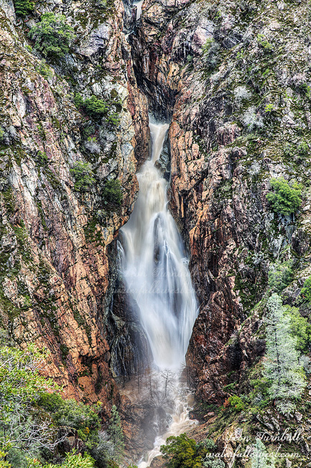
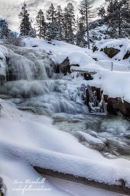
    I have always wanted to visit Canyon Creek Falls when it is at crazy flow. All guns blazing. Off the charts bonkers. Check one off the bucket list now.

      On Friday the big Pineapple Express rolled on through northern California, whetting all our appetites (literally). We received 5.6 inches of rain in the Sierra foothills. Unfortunately, the snow levels were really high this time, so that means the snow was melting on top of the rain. That raises the river levels exponentially. On Friday night, the North Fork American River peaked at a whopping 20,000 cubic feet per second (in other words, a lot) – it was under 1000 before the rain started. When I woke up on Saturday, it was still at 19,000 but dropping fast. I scooted on up the hill as fast as allowed by the law, and arrived at the trailhead by sunrise.

        It is a fairly easy hike, but there are some steep parts. With the ground saturated and wet, it was very slippery and muddy. I fell one time, getting my clothes thoroughly mud baked. After that, I was extra careful on the steep parts. I did not want to put my back out again. Also, I did not want to slide right off a cliff. That would not be out of the question, if I was not paying attention. I paid attention.

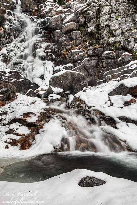
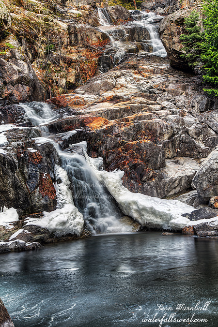
          Arriving at the viewpoint … and WOW. This is the absolute best I have ever seen the Big Waterfall, which is 144 ft. high. The view of the North Fork American River was stunning, the river was roaring below me, unnamed waterfalls cascading down every mountain. It is difficult to know exactly what the river level was at because there is a delay from the time it takes for the water to reach the gauge at the North Fork Dam, but I believe it was in the range 16,000 to 18,000 cfs. Last time I was here, it was around 6000 to 7000 cfs, so that means Canyon Creek had about 2 to 3 times the flow as last time. Absolutely amazing. If you have never been to this viewpoint before, you need to add it onto your list too.

            So now … what about the rain and snow situation and El Nino? It is the end of January and we are halfway done with winter. After this latest storm we finished January at 122% of average rainfall. The snowpack is 117%of average for Central Sierra, 120% for the North, and 107% of average for the Southern Sierra. Folsom Lake is at 54% capacity (average for this time of year), Shasta is 52% and Oroville is 43% – and these will rise more this week from the rest of the rain runoff. So that is all good, right? Or is it?

              Certainly it is good when compared to the last four years. I’m not going to complain. However, everyone is talking about El Nino this and El Nino that, but what are the facts? The fact is we have only had 1 or 2 El Nino storms all this winter. Almost all the storms we have had have come from the Pacific Northwest. Not that it is a bad thing, but southern California has been very dry thus far and I certainly would have expected (and hoped) that by the end of January this super strong El Nino would have had a much bigger impact than it has, and we would have even more rain than we have had up to now. What about February? That nasty old ridge is building in this week, and the long range forecast is indicating that we are going to have a dry February, at least for the first couple of weeks. So even though we are above average for now, by the middle of February we will probably be back below average. They are already talking about releasing water from Folsom reservoir. That would be a huge mistake if they do that now. Bottom line … we need to keep praying for rain and an end to this ugly drought.


                3 Comments

                SNOW PLAY

                I did not get to anything new on this day, but it was a fun day to play in the snow.

                Actually, I was hoping to get to one new waterfall but as soon as I arrived I knew it would be impossible. There was too much snow on the ground, the waterfall would be completely covered, but I knew Rattlesnake Creek would be flowing.

                There was about 9-10 inches of snow on the ground at Cisco Grove. That was a bit less than expected from the last storm, but still too much to hike in. Unless you have snowshoes, which of course I did, and which of course I used. I trudged through the snow for a half mile, without too much difficulty, but it was tough sledding. After that, I came across snowmobile tracks from the previous day, going up the mountain. That made things a lot easier for me to just walk in the already laid out tracks. How far would they go? Not far enough, apparently. The snowmobiles had turned around about a half mile from the Middle Falls, and so I continued trudging on through the almost but not quite one foot of snow. I arrived at the Middle Falls, and it looked pretty, but how to get up close to it? That was definitely a challenge, but a fun challenge. I got off the main road, and worked my way over to the creek. It was much deeper snow through here, and I had to descend a steep bank, over a few logs, cross a mini creek, over some more logs, not knowing what exactly is under my feet (in other words, am I going to fall through and into the freezing cold and deep creek?), carefully, ever so carefully, and finally I arrived at the base of the Middle Falls. I got out my camera, had to climb over some more logs, this time I could see the huge hole under my feet, but I kept my snowshoes placed carefully on secure logs (I hope they are secure!) in order to not fall through into the freezing creek (and henceforth die), then finally got in front of the falls, I set up my tripod, planting it through the snow and into the creek, while I sat down on a snow covered rock, with my snowshoes still securely planted on the logs. Does that sound like an adventure to you?

                Anyhow, all that done, I turned around and did everything in reverse, finally getting back to the main road in one piece. I decided to skip the upper falls, as that would have been a heckuva lot more effort, another four miles of snow hiking. I still had time to get back to the Lower Falls before it got in sun, so that’s what I did, making it down there just in time. With the increased amount of snow, I found it a lot harder to get up close to the Lower Falls, and even had to (literally) climb straight up the lower cascade in the creek, in order to get up to it this time. That was rather hair raising. I also fell through a huge hole climbing down to the creek. As I fell, my mind was racing, wondering just how far I was going to fall through, and if I would ever see the light of day again. I only fell through to my waist and no injuries, but I suppose it could have been worse. I will share that photo later.

                The storms we have had this year so far, including these last two big ones, are still not El Nino related. The storms this year so far have been pounding the Pacific NW, and California has just been getting the last remnants of their stuffings. As usual, that always seems to be the case for us. We are still well below average for the year thus far. In an El Nino pattern, the Pacific NW will be dry, and southern California will be hit hard. I am still anxiously waiting for us to get into that El Nino storm pattern, but now it looks like that may not happen until mid January, which is very late for such a strong El Nino. Sigh. I saw one news article saying that El Nino is destroying the Polar Vortex this year. It is true that the Polar Vortex is nowhere to be seen in the east this year, and the east has been very dry thus far, but I am not sure that El Nino has anything to do with it. Nonetheless, for all you easterners, I say too bad so sad. You have had four good years in a row, while we have been suffering in a horrendous drought. It is our turn this year, so deal with it (and hopefully, much more than just one year too). Can I hear an Amen?

                1 Comment

                NOBODY ON THE ROAD

                This was my favorite of the five waterfalls I found on Grayhorse Creek last weekend. It looks drop dead gorgeous in the snow, and is 66 feet high.

                From the lower falls it is a steep and tough climb up the canyon, and the further I gained in elevation the more snow I found. By the time I got to the upper waterfalls, there was quite a lot of snow and ice in the creek, making for some gorgeous scenery. Strangely, I found an old sign on a tree near the upper Falls which said “State game refuge”. It is hard to imagine that anyone had ever been up so far in this remote canyon before, let alone would put a sign up here on a tree. Yet I did see an old Trail up here, following it here and there, so obviously people have been up here before at some point in the distant past, but it is not one that anyone likely knows about these days.

                This beauty is not the biggest waterfall on the creek however. Just above this 66 foot falls is a massive waterfall, perhaps 400 feet high, not far off the magnitude of Horsetail Falls. The lower section is easily seen, but it gets very steep very quickly, and viewing this monster is going to be a challenge. It is one that is going to look a lot more impressive in the spring time and I will be back here then for sure, but I am not sure what kind of views I will get of it.

                Well it was getting late in the day, the sun was out now, and I had to make my way back down the canyon and then back up to the car. I saw no one, absolutely no one the entire day. Even back at Hell Hole reservoir I saw no one, and no cars on the road either. It was not until I got back on the main highway to Georgetown, and hearing the song that came on, the first words of which Don Henley sings “nobody on the road”. Ironically, immediately after he says those words, I see the first car on the road. If you know which song that is without looking it up, then you are awesome and you get 10,000 points.

                1 Comment

                IN THE HOLE

                When I discovered this waterfall on Grayhorse Creek at Hell Hole Reservoir last spring, I could not get down to it because I was backpacking and did not have a rope with me. I thought it might be possible to get to it with a rope, so it was high on my list to return here. I made it just in time. One more storm and this area will be closed for the winter.

                The forecast for the last storm was 4-8 inches at this elevation. I was definitely thinking it a good possibility that I would not make it there. Eight inches is about the limit for my SUV. My next vehicle is going to have much more clearance for sure, but it’ll be a few years before I can afford another one. I had hoped to be at the trailhead by 6AM, but the drive was very slow going due to the snow on the road, not to mention that it was very icy. Ending up in the ditch would not be a good idea. Or even worse, off a cliff. As it turned out, other cars had driven the road the day before, and there was only 4-5 inches of snow. So it was on the very low end of the forecast, which in a way is disappointing because we need that snow, but I might not have made it there if there was more than 8 inches of new snow. I arrived at the trailhead at 6:30AM, 30 minutes late. It was going to be a stretch to make it to the waterfall before the sun got to it. Well I had to try.

                Off I trampled through 4 inches of snow, following deer tracks and coyote tracks. Those coyote tracks looked pretty darn fresh, I wondered if I was going to catch up to him or not. But alas, I saw nothing but a friendly squirrel (at least, I assume he was a friendly squirrel). It was a beautiful crisp morning, perfect for a snowy hike, and a pretty nice sunrise overlooking Hell Hole Reservoir with fresh snow on the mountains (I did stop to take a photo). Unfortunately, Hell Hole Reservoir is looking pretty sad, but we are still praying that will change this spring.

                I reached the creek above the falls a bit after 8AM. It seemed to still be in shade, but not for much longer. I got out my rope to begin the descent, but it was snowy and icy, and felt much too dangerous, a lot more dangerous than my recent trip to Patterson Creek. Uh, what should I do. Well I thought, what if I went further downstream, and then came back to the falls along the creek bed. The water flow was much lower than in the spring, indeed I had thought it would be flowing a lot better after this recent storm. It was easy enough to get down to the creek downstream, no rope required, and then it was very simple to walk up the creek bed. I did not even get my feet wet. I got up to the waterfall, and it was spectacular, a lot bigger than I had previously estimated: 69 ft. high, just falling a foot short from the 70 ft. marker. The flow was low, but it was still gorgeous. It would certainly be amazing in the spring if you can get down to it. I was ecstatic to make it here, but it was still early, and I was hoping to find even more waterfalls on this creek. And indeed, I did. And they were even more amazing than this one. Come back soon to find out.


                No Comments

                ON THE EDGE

                I know this is not a good photo, but it is the best I could muster up today.

                I went back to the East Fork of the North Fork of the North Fork American River (EFNFNFAR) again this weekend, trying to get to that mischievous and elusive upper falls. I found it, however it was not exactly what I hoped for.

                I left the dirt road and headed straight down to the river. I was pretty certain I could come out right at the base of the waterfall, and have a perfect view of this crazy thing. Not quite. The descent was very brushy, in particular near the top, but I persevered and got through the worst of it. Continuing on down down down, 700 ft. down. It was not too steep or cliffy, and I soon began to think my grandiose plan was going to be perfection again. Then I came to the last 100 ft. of the descent. Cliff. Cliff. Everywhere a cliff. I made my way a bit further downstream, and found a non cliffy descent, it was steep, but I made it all the way down to the river. When I got down to the river, I saw a tripod head laying there. Gee, I thought, someone was down here before and dropped their tripod head. That is not very good at all. I looked a bit closer … that sure looks very similar to mine. Umm, wait that is mine! Crashing through the trees down that steep terrain, it must have come off the tripod and rolled on down ahead of me. Dang, I could have easily lost this and not even had a clue.

                All righty then. I scooped it up and screwed it back on the tripod (securely). Now I just needed to work my way upriver to the falls, I really thought I was going to make it without any difficulty. I was almost there. I came around a corner, face to face with a deep and large pool, followed by a 15 ft. cascade, cliffs on both side, and no way to get up past it. The main waterfall was just out of sight, above this little cascade and around the next corner. I was skumped. And I was so darn close.

                Well I went back, and then climbed up the mountain the way I came. I tried to get over closer to the waterfall above it. Maybe I could at least get a good view of it. Well here it is, I found a view. I was literally hanging on the edge of the cliff, looking down at the falls. I could not find any good place (or any place at all) to put my tripod, so I had to take the photo hand held. Not very good, but what can you do. It does not look very big from the photo, but the waterfall is really 30 ft. high or even more (I could not get an official measurement either).

                It is a nice one, but man oh man is it so darn elusive. And absolutely impossible to get to, unless you are going to rapel down the river from above the falls. As you can see, it looks like someone has actually done this, and they left their rope hanging beside the falls. That quite annoys me and is very irresponsible to leave your rope out in a pristine canyon, so that the next person to come here (ie. me) has to look at your ugly rope beside a beautiful waterfall. Leave no trace, people! End rant. End story.


                4 Comments