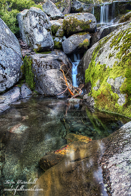
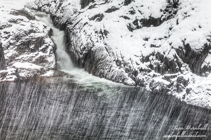
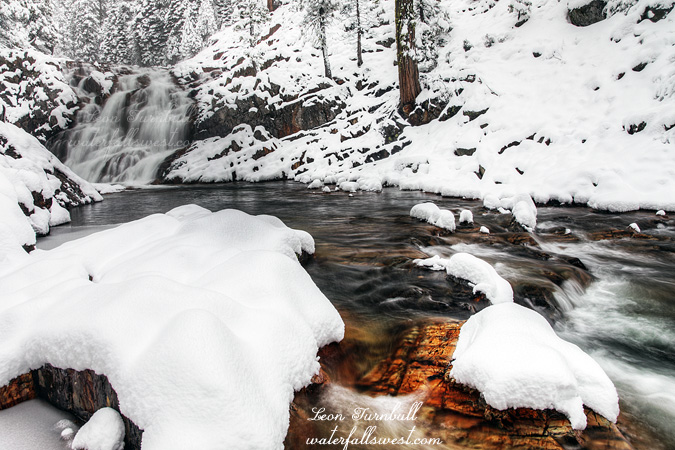
LONG OVERDUE

I have known about Donner Summit Falls for some time now of course, but had never been there before. You can see it as you whip by it at 80 miles per hour on I-80. Oops, I think you just rear-ended that slow moving car in front of you when you cast a glance over at the falls. Seriously though, why have I not been here before? Well … well … no good excuses really. Except that it is an awfully long drive up there, and all just to see a roadside waterfall? It is in the full sun pretty much the entire day and flows only in the spring, there’s nothing really else in the area, and just how big is it anyway? It didn’t really seem worth the effort. Plus I was not really sure how to get to it.

But … I had to do it sometime, right? And so I came up with a plan. I would go see Donner Summit Falls, arriving at sunrise, and then I would have time to go on a second hike to a second waterfall in good light as well. Now what about how to get there? There is no place to stop along the freeway. Well, maybe there is a way, but it seemed better to approach it from the other side. Perhaps I could hike down to it from the rest area. It would be quick and easy, and give me lots of time to get there by sunrise and get in that second hike as well. However, when I arrived at the rest area, I found a lot of signs, NO TRESPASSING signs. Doh. This would not work. Ok well what about from the Boreal ski resort? There is a trailhead there for the Pacific Crest Trail and that trail takes you close to Donner Summit Falls. So I drove all the way down to Donner Lake to get back on the freeway going the other way and back to Boreal, where I got to the PCT trailhead, still in the dark. I could not see where the darn trail started in the dark, however (even though I was right next to it). I guessed that with all the snow, it was not traveled in the winter. Well, I spent a lot of time trouncing through the snow in the forest, then finally got on the trail proper. It actually was quite well traveled, and now it was easy to follow. When I got over towards the waterfall, I got off trail, got on my snow shoes, and made my way down to the bottom of the falls. I didn’t quite go the right way, however, and it took longer than it should have. I finally got to the bottom of the falls, 10 minutes past sunrise, and the sun was already starting to hit the falls. With all that extra trouncing around, I was just a bit too late. But actually the photo turned out pretty nice. The comp was difficult. It would have been much better to shoot it from the other side, but it was too icy and I could not safely cross the creek. Still though, not too shabby. Donner Summit Falls is 34 ft. high, and if you can ignore the traffic whizzing by above you, it is a sweet one.

Speaking of long overdue, where is our snow and rain this year? Still much of nothing in the long term forecast. What little snow we have is melting quickly. The only reason Donner Summit Falls is flowing is because the little snow that is melting.

And here is another thing that I do not understand. At the PCT trailhead at Boreal is a mess of broken sleds. Not only at the trailhead, but scattered in various places along the trail. This is a popular area for sledding, but what the hey? If you break your sled you have to just litter it along the trail? Why are people such idiots that they cannot take their broken sled and dispose of it properly? Ugh! End rant.

2 Comments

DEJA VU

Does this winter weather seem familiar to you? It seems to me that it is shaping up to be exactly like last year, just like the last three awful years. Deja vu. We had a good start to the winter in December (just like last year in November), then completely nothing in January this year (just like last year), and the long range forecast now looks extremely bleak as well. El Nino was a bust. No show. We did not even get a weak one. With a weak El Nino, at least we would have a chance for more precipitation, at least somewhere closer to average. The neutral ENSO conditions we have now are exactly like we have had the last three years, for which our average precipitation has been well less than 60 percent of average. The news I just heard regarding the weather conditions for the rest of this winter was horrid. It was so horrible, I do not even want to share it with you. That is because it just cannot be true. I refuse to believe it.

I am tired of the awful weather we have had, four straight years of it. I am tired of waiting patiently for the weather to change for the better, but then it never does. I am especially tired of trying to figure out what waterfalls will be flowing and which ones will not be flowing. At this time of year, ALL the waterfalls should be flowing, and flowing very well.

Case in point, this weekend: Serena Creek. I had no idea if the creek would have water or not. The creek is dammed at the lake and goes dry in the summer. The creek will only have water in it if the lake is full, and I did not know if it was full yet or not. It should be full of course, but we are in a drought, and it seemed more likely that it would not be spilling. I had a backup plan of course. I always have a backup plan. Well, I arrived at the trailhead in the dark, and I could hear the water spilling over the dam. The creek had water, and the waterfall would be flowing. I was good to go on this hike.

Well, with the major potential issue now in the back pocket, I had more dilemmas to deal with. Should I wear my winter jacket or my lighter jacket? Should I wear my winter boots (which were warmer and waterproof) or my hiking boots (for more traction)? Should I take my snow shoes or not? Would I be able to even get down to the falls at this time of year, or would it be too icy and dangerous? First world problems, I guess, but I hate that term so I am not saying it (did I just say it?). I decided to wear my winter jacket because it was less than 30 degrees. Good choice. I decided to wear my winter boots and keep my little toes-ies warm. Good choice. I decided to take my snow shoes. Also a good choice as I ended up using them – I probably could have gotten by without them but it would have been much more difficult.

It was still dark when I started. I had just bought a new light for my bike, which is a very bright one. I needed it for biking to work in the mornings, but since it was so expensive, I wanted to see if it would work for hiking as well because it is much brighter than my hiking headlamp. I could not figure out any way to wear it on my head with a head mount. It just would not work, but I managed to use the mount and attach it to my hiking pole. It was a bit weird, hiking with the light on my pole, but it did work, and it was certainly much brighter than my regular headlamp. I think the experiment was a success.

The hike begins along the road which is popular in the winter with snow shoers and cross country skiers, and people just taking their dogs for a walk. I was surprised to see someone had driven down the road in the deep-ish snow. Seems pretty crazy to me, but I guess it made the hike for me a bit easier because I could walk in the tire tracks. It was also very icy. That could be a bad sign, as I figured it might be a bit cliffy when I got to the waterfall. Eventually, I had to get off the road and make my way down to the creek. This is when I put on my snow shoes, and it made for an easy trek down to the creek. The snow, however, disappeared when I got down to the cliffs above the falls. That was good, I suppose, because it allowed me to get down to the bottom of the falls without much difficulty or danger, but I was hoping to get photos of an icy waterfall.

Serena Creek Falls is a gorgeous 80 ft. waterfall in multiple tiers. The surrounding landscape and rocky terrain and the waterfall itself were uncannily similar to Little Robinsons Valley Falls, which I was just at a month or so ago. There is a small upper falls, followed by a nice cascade, and then a gorgeous drop in a fan shaped falls. Exactly like Little Robinsons. Deja vu, again. It is obvious many people go down here, but it seems that only the locals know about this waterfall (before now). I had heard of Serena Creek Falls for the first time only last year. When I tried to come to it last spring, however, the creek was completely dry. It should have been fine, but the stupid drought nullified that. Well lets try again this January, and this time I had success. The big difference between this one and Little Robinsons however, is that there is a lower falls here. I did not know about this lower falls, and no one has previously documented this lower falls; I am the first to do so. I suspected there might be one, however, so after shooting the upper falls, I continued exploring downstream. Before long I came to the top of the lower falls, hidden behind the cliffs, but a path led down to the bottom where I found this beauty. I liked this one much better than the upper falls. It was completely gorgeous. Both waterfalls I measured to be exactly 80 ft. high. Go figure. It was an amazing and happy day at Soda Springs.

2 Comments

BACK TO DRY

So you think we had a lot of precipitation in December, do you? I know the media was saying this before Christmas. Well, the official December tally from the NOAA indicates the truth: we are only at 45% of normal for our snowpack in the Southern/Central Sierra, and 55% for the northern Sierra. That is WAY BELOW average. We did have warmer precipitation earlier in December which did not add to the snow pack, but the overall precipitation was also below average and the rain did not do much of anything for our reservoirs. Folsom is currently at about 45% capacity, and Shasta/Oroville are 40% capacity, and this is also way below average. The worst part of all this is that we have been mostly dry for a couple weeks now and from what I have read the long range forecast for the rest of January is looking extremely bleak, barring a miracle (which I’m still hoping for). This will make it 8 out of the last 9 Januarys being dry months, and now we are seriously looking at the possibility of a fourth year in a row of far below average snow pack. But we still have February and March. Don’t give up hope yet.

This is 18 ft. high Fiddle Creek Falls, and it was still flowing quite strongly when I was here. A nice little falls right alongside the road. I would not have gone out of my way to stop here since I have been here before, but it was not out of my way, so thus I stopped! The flume at the top is interesting. When I was first here years ago, I thought it was just an ugly thing that needed to go away. Now I am torn. On the one hand, I wish it was not here, but the more I see of this waterfall, the more I think the flume is very much part of its character. It’s like the log across Lion Slide Falls or the ones at Russian Gulch Falls. Fiddle Creek Falls would just be naked without the flume there.

Comments Off on BACK TO DRY

SURPRISE

So here is my tally for the Christmas holidays of 2014: 5 hikes, 8 waterfalls (6 new ones, 1 old one, 1 sort-of-new one), 30 miles of hiking, 4000 ft. elevation of climbing (at least), one very bad case of poison oak, one injured rib cartilage. Not too shabby. The worst thing was the oak (ugh!). The best thing was Cherokee Creek Falls (see my last post).

This one, however, was a very pleasant surprise: Wet Ravine Falls, 33 ft. high. I found it right alongside the road as I was driving back down the hill from Cherokee Creek. I had no idea there was a waterfall here beforehand, but there it was, and for such a small creek, it was flowing quite nicely. Easy to get up close to, but a bit difficult to photograph.

I found it quite strange that some creeks in the Downieville area were flowing very strong, and others nearby had hardly any water in them at all. That was disappointing in some respects because I had hoped to get to see some more falls in the area that day. Wet Ravine was a nice surprise though, as I wouldn’t have thought this would be flowing at all. Sweet.

2 Comments

FOGGY CHRISTMAS EVE

On Christmas Eve I headed up to Downieville. My goal: Attempt to get down to the monster waterfall on Cherokee Creek.

I had little hope for success. On Google Earth, it looked incredibly steep, cliffy, brushy, and it did not look like there were any open views to the waterfall. It was worth a shot though, of course. 😉

I arrived at first light. It was steep but not cliffy or brushy (yet). There was a lot of poison oak on the descent, however. Once again though, I seemed to have managed to avoid getting the big itch. I’ve been doing well at that lately (knock on wood). I continued the descent, deftly avoiding touching anything of the oak variety. I came to the spot where I hoped I could get a view of the thing, on top of a cliff overlook. Oh, but there were just too many trees in the way. It was so close. It would have been a magnificent view point if it were completely open. If I hung my body out over the cliff, whilst holding onto a flimsy tree branch, then I could get a pretty clear view (but uh, no thank you on that one). I thought I was done for, and there would be no further entry down the mountain. But then I saw that I could continue down further without any death defying maneuvers necessary. Just a little further down and I came to this spot with a clear view of Cherokee Creek Falls. This plunge shown here is 79 ft. high. Just as I got here the fog rolled in, completely obscuring my view of the waterfall. But I absolutely could not leave here without a good decent photo. So I waited. And I waited. And I waited. Finally, the fog cleared slightly. Just enough to take a decent photo.

There is a lower tier of this waterfall, about the same height as the upper tier. I was able to continue further down the mountain, but I could not find any clear spots to photograph the lower tier. The terrain got too cliffy to go much further, so I headed back up the mountain. I still had more waterfalls I wanted to visit this morning and I had already taken much longer than I wanted at Cherokee Creek, but it was worth it. What a magnificent waterfall.

7 Comments