So you think we had a lot of precipitation in December, do you? I know the media was saying this before Christmas. Well, the official December tally from the NOAA indicates the truth: we are only at 45% of normal for our snowpack in the Southern/Central Sierra, and 55% for the northern Sierra. That is WAY BELOW average. We did have warmer precipitation earlier in December which did not add to the snow pack, but the overall precipitation was also below average and the rain did not do much of anything for our reservoirs. Folsom is currently at about 45% capacity, and Shasta/Oroville are 40% capacity, and this is also way below average. The worst part of all this is that we have been mostly dry for a couple weeks now and from what I have read the long range forecast for the rest of January is looking extremely bleak, barring a miracle (which I’m still hoping for). This will make it 8 out of the last 9 Januarys being dry months, and now we are seriously looking at the possibility of a fourth year in a row of far below average snow pack. But we still have February and March. Don’t give up hope yet.
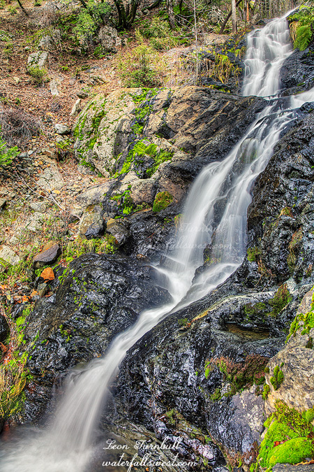
This is 18 ft. high Fiddle Creek Falls, and it was still flowing quite strongly when I was here. A nice little falls right alongside the road. I would not have gone out of my way to stop here since I have been here before, but it was not out of my way, so thus I stopped! The flume at the top is interesting. When I was first here years ago, I thought it was just an ugly thing that needed to go away. Now I am torn. On the one hand, I wish it was not here, but the more I see of this waterfall, the more I think the flume is very much part of its character. It’s like the log across Lion Slide Falls or the ones at Russian Gulch Falls. Fiddle Creek Falls would just be naked without the flume there.
Posted in Northern Sierra, Waterfalls by leapin26: January 2, 2015
So here is my tally for the Christmas holidays of 2014: 5 hikes, 8 waterfalls (6 new ones, 1 old one, 1 sort-of-new one), 30 miles of hiking, 4000 ft. elevation of climbing (at least), one very bad case of poison oak, one injured rib cartilage. Not too shabby. The worst thing was the oak (ugh!). The best thing was Cherokee Creek Falls (see my last post).
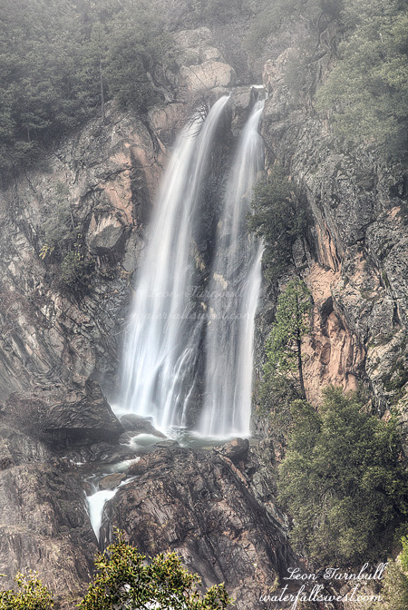
This one, however, was a very pleasant surprise: Wet Ravine Falls, 33 ft. high. I found it right alongside the road as I was driving back down the hill from Cherokee Creek. I had no idea there was a waterfall here beforehand, but there it was, and for such a small creek, it was flowing quite nicely. Easy to get up close to, but a bit difficult to photograph.
I found it quite strange that some creeks in the Downieville area were flowing very strong, and others nearby had hardly any water in them at all. That was disappointing in some respects because I had hoped to get to see some more falls in the area that day. Wet Ravine was a nice surprise though, as I wouldn’t have thought this would be flowing at all. Sweet.
Posted in Northern Sierra, Waterfalls by leapin26: December 30, 2014
On Christmas Eve I headed up to Downieville. My goal: Attempt to get down to the monster waterfall on Cherokee Creek.
I had little hope for success. On Google Earth, it looked incredibly steep, cliffy, brushy, and it did not look like there were any open views to the waterfall. It was worth a shot though, of course. 😉
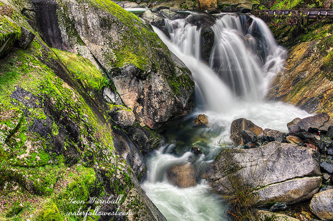
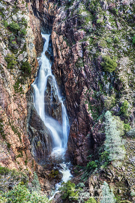
I arrived at first light. It was steep but not cliffy or brushy (yet). There was a lot of poison oak on the descent, however. Once again though, I seemed to have managed to avoid getting the big itch. I’ve been doing well at that lately (knock on wood). I continued the descent, deftly avoiding touching anything of the oak variety. I came to the spot where I hoped I could get a view of the thing, on top of a cliff overlook. Oh, but there were just too many trees in the way. It was so close. It would have been a magnificent view point if it were completely open. If I hung my body out over the cliff, whilst holding onto a flimsy tree branch, then I could get a pretty clear view (but uh, no thank you on that one). I thought I was done for, and there would be no further entry down the mountain. But then I saw that I could continue down further without any death defying maneuvers necessary. Just a little further down and I came to this spot with a clear view of Cherokee Creek Falls. This plunge shown here is 79 ft. high. Just as I got here the fog rolled in, completely obscuring my view of the waterfall. But I absolutely could not leave here without a good decent photo. So I waited. And I waited. And I waited. Finally, the fog cleared slightly. Just enough to take a decent photo.
There is a lower tier of this waterfall, about the same height as the upper tier. I was able to continue further down the mountain, but I could not find any clear spots to photograph the lower tier. The terrain got too cliffy to go much further, so I headed back up the mountain. I still had more waterfalls I wanted to visit this morning and I had already taken much longer than I wanted at Cherokee Creek, but it was worth it. What a magnificent waterfall.
Posted in Northern Sierra, Waterfalls by leapin26: December 27, 2014
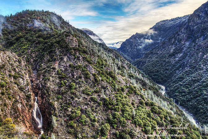
Here is some perspective for you of 144 ft. high Canyon Creek Falls. The North Fork American River is below right. You can see Bogus Point straight ahead and Lovers Leap peaking out behind it with a nice bit of fresh snow on it and the surrounding mountains. I have never seen the waterfalls on unmarked streams flowing off the distant mountains before.
This photo is just for my sister in law. She’s always asking me why I never show any sky in my waterfall photos. Well it’s not like I hate the sky. What she doesn’t understand is that sky normally does not work in waterfall images. It is usually detrimental to the image and intrusive. Plain blue sky is boring and overcast sky is ugly. Either one or other of these are almost always present when I go hiking, or else more likely the sky is non existent deep inside the canyon where the waterfall is. It is better to focus on the waterfall itself and usually it is the only option. But sometimes sky works very well and this was such a case. The light clouds and fog added a lot of interest in this scene to the surrounding mountains, and a superb sense of scale for the waterfall. It is an amazing spot.
Posted in Northern Sierra, Sacramento, Waterfalls by leapin26: December 17, 2014
Some of you were wondering where I would go after a huge rainstorm, like the one we just had (or more accurately, supposedly had). There is only one answer to that question: Canyon Creek Falls.
The so-called storm of the year, hugely over-hyped by the media. The biggest storm in six years. Storm-aggedon. Rain-ocalypse (as I called it). Binky (as a friend of mine was calling it). I think not. Okay okay, well I think they did get quite a bit of rain in the Bay area, and also in northern California. But it seemed to bypass the northern foothills and Tahoe area. We were supposed to get 5-7 inches in the northern foothills, and we only received about half that amount. We did get much needed precipitation, but in fact, the storm last week was bigger than the one this week, for our area at least.
I was anticipating waking up to see the North Fork American River with at least 8000 cubic feet per second flowing, and hoping for even twice that flow. It would have been the case if the rain forecast had been true. However, it was only at 4000 cfs, and that is the amount it peaked at for this storm. It was only half the amount that I expected it to be.
I have been wanting to see Canyon Creek (which flows into the North Fork) at monster flow for many years now. It is gnawing at my insides. Driving me to insanity. Yet, Canyon Creek Falls continues to be an elusive beast for me. Oh yes, it would be flowing very well, fantastically well. But it would not be the monster flow that I want to see before I die. That I must see before I die. So … I drove up the hill and hiked in to Canyon Creek Falls anyway.
The flow was almost identical to the time I was here last. I compared photos from last time, and I could tell it was just slightly more this time around. Not monster. But still awesome. The rain was done for the time being. The sun was trying to come out. The view was astounding. I could see waterfalls flowing off the distant mountains on unmarked streams. I had never seen that before. The North Fork American River was remarkable, flowing strong far below me. Light clouds and fog were enveloping Lovers Leap and other mountains. It is an incredible spot and I was happy to be there.
Enjoy the present. We can thank the Lord for every drop of rain we get, it is all so much needed. Perhaps next time I’ll see that monster flow. Bring on the next rain-ocalypse.
Posted in Northern Sierra, Waterfalls by leapin26: December 14, 2014
