MORE WATER!

This is the upper tier of Little Robinsons Valley Falls, 61 ft high. To get to this ledge I had to very carefully traverse a slick wet ledge with a big dropoff into the raging creek below, at the top of another big waterfall. Fun times. Seriously though it wasn’t that bad. The last sentence is for my wife, in case she is reading this. LOL.

Starting tonight they say we are going to get slammed with our biggest storm in six years. Awesome! We should get at least five inches of rain in the foothills and multiple feet of snow on the mountains. Bring it on, I say. We so need this. There will be much more water flowing after this storm. Thank the Lord. Saturday will be an amazing amazing amazing waterfall day. I’m supposed to be at my daughter’s dance studio all day on Saturday. Humph.

No Comments

WATER!

Well from the last two storms we had 9.5 inches of rain in the Northern Sierra Nevada foothills. The snow levels were high, however. Bad news for skiers but good news for waterfall hunters. It is unfortunate though, because we desperately need that snow pack. Nonetheless, an interesting window opened this weekend. In particular for me, Foresthill Rd would have no snow on it.

I thought long and hard about one waterfall in particular: 462 ft. high New York Canyon Falls, my all-time favourite waterfall. I would love to see that one up close at full blast. This could be a unique and very rare opportunity. Since the rain fell on Wednesday, Thursday would have been the best day for waterfallin’. However, I just could not take a day off work this week. That left Saturday. By that time, the North Fork American River was down to under 1000 cfs. I was really hoping that another inch of rain Friday night would fall, bringing up the river again but the river was down even more when I woke up on Saturday. It seemed as though it did not rain an inch overnight as it was supposed to do.

So I made the executive decision to try a different hike: Little Robinsons Valley. I have wanted to check this one out as well and it seemed like a good opportunity. It was cold and blustery and foggy and still raining when I started my hike early in the morning from Robinson Flat. Sounds like a perfect day to be out hiking. And it was. A short hike down the trail, then head off through the mud and brush towards the creek. There was lots of water everywhere. In the creek, on the trail, off the trail. The creek was running hard when I arrived. Could I get down safely to the bottom of the falls? It was surprisingly not difficult, though definitely a bit tricky because of the slick wet rocks. I was careful though, and I made it right to the base of the falls. I am very surprised (yet again) that no one seems to have known about this waterfall, especially since it is so close to Robinson Flat campground and really quite easy to get to. Of course, in the summer the creek will be dry. But right now it was awesome. There are three waterfalls here, though I would consider them all as a single tiered waterfall 109 ft. high. This final drop is 48 ft. I have more pictures of this one to come. It is an amazingly beautiful area, and there were waterfalls coming off the mountain from unnamed and unmarked side streams. It was magnificent.

As it turned out, I think New York Canyon would have been awesome after all. I suppose I should have gone there instead, but Little Robinsons Valley was pretty darn incredible too. Anyway, I have other “secret” plans for NYC later. Wink wink.

1 Comment

BRUSHY

Nine. Nine new waterfalls I have found so far this season (in the last two months). And the season has not really even begun yet (but it will very soon – our first big storm of the year is on its way). Anyway I think that is a huge accomplishment. Nine new waterfalls that most people had no idea even existed. And much more is on its way in the coming months. Of course, some waterfalls are better than others. And this one I suppose is on the lesser side of things.

At least it lived up to its name: Brushy Canyon Falls. I did not think it would. In fact, I anticipated this would be an easy hike (or fairly easy hike), and I would be able to see the waterfall from the main road. Upon Google Earth examination, it seemed the terrain was quite open, and there would be a pretty good view from the road. It was a 2 mile hike down to the supposed viewpoint, and even though you lose 1000 ft. in elevation on the road, I was up for that hike. The hike down was mostly uneventful, but when I arrived, I could see no waterfall from the road. There was much more brush than anticipated, and it was blocking all views of the waterfall. Well time to go down, then.

The problem, however, was there was a cliff in the way between me and the waterfall. It was steep, darn steep, scary steep. I did not want to go down, but I had no other choice. I descended carefully and slowly. I had to get out my rope to help me get down safely. I finally came to a little knob with this view of the waterfall. But again, there was brush and trees in the way, and a clear view of the entire waterfall was not possible. Only the top part could be seen from here. I had run out of rope by the time I got down to the knob, and it was still rather cliffy. Too cliffy to continue down any further. I may or may not have been able to get a better view further down, but there was nothing else to do but turn and go back up the mountain. Another day I suppose I will come back with more rope to try it again.

This was taken on Thanksgiving Day. Normally I like to go out hiking on Black Friday, but Thanksgiving Day is good too, and it worked out better this year to do it on TD. Surprisingly, there were a heckuva lot of cars out on the road so early in the morning. Why so many people out and about? Fortunately, I did not see anyone out on the trails. Of course, no one would have been on this trail anyway since no one knows about it. I had also thought this creek would have a lot more flow which is one of the main reasons I picked this one. But it was already on the low side, even after an inch or more of rain in the past week. Well, a lot more is on the way. Five inches perhaps, next week. Sweet galoshes. About time.


2 Comments

LA LA LA, NEW WATERFALL

Yeah this one would be awesome if there was more water in the river, but I was still really really pleased to find it. Actually, I thought there would be a lot more water flowing in the river. Indeed, I was sure of it. Last weekend, the river was flowing very well, and we had some more rain during the week, so I was sure it would still be flowing. I’m really not sure what happened, but the flow was way down.

This is Emigrant Gap again, and it is the third weekend in a row I went here. The road will be snowed in for good pretty soon, probably even by next weekend, so I do like to get up in this area when I can. There were no hunters this weekend. In fact, I did not see anyone at all (just one truck, and that is all for the entire morning). This time my goal was the East Fork of the North Fork American River, specifically the upper reaches of this river.

I was not sure there would be any waterfall up there at all, but after thoroughly examining my topo maps and Google Earth, I thought there would be a possibility of a small waterfall, and it certainly was worth trying, especially if the river was flowing, which of course I figured it must be, based on how it looked last week. I also figured it would be a very easy hike, which also sounded good to me after the killer one last weekend.

Well you know me, the Waterfall Madman does not end up doing anything easy, and this was no exception. The hike started off easy enough, a simple 1 mile jaunt on a logging road over towards the East Fork. It was cold too, 32 degrees when I started out. And the wind was crazy wind. It was very brisk and cold, but it felt terrific. It made me feel alive. It was a splendid day to be out in the beautiful creation, and I needed to be out there this day. I absolutely needed to be out in the wilderness. Then the road ended.

So what do I do now? Do I cut down to the river and try to work my way upstream? Or do I attempt to traverse the ridge, and then hopefully find a way down the cliff when I get to the waterfall (if there even is a waterfall). I chose the latter, and it was a good choice. At first, though, it did not seem so. The manzanita brush was thick along the ridge, much thicker than I expected. It seemed so open on Google Earth. This brush could be a show stopper for sure, but I continued on, hoping for a path through it, and indeed I found one. It was tough going but finally the terrain became more open, more like what I saw on GE. I saw no trace that any human had ever been up this way before. That’s the way I like it. The only thing I found was a bear path leading me through that brush. They are good at trampling through that stuff. Thank you, bears. I love you.

The ridge came to an end at the start of the gorge, and fortunately not too cliffy. I made my way down to the river, and there it was: a beautiful 34 ft. high waterfall dropping over a rock ledge into an icy pool. The Madman was very happy, the first to find and document this waterfall. It was quite a lot bigger than I expected to find (actually I didn’t think I’d find anything), and all in all, it really was not all that difficult to get here. I love it when a plan comes together. I will certainly come back when I know the river is flowing well (which will probably not be until the spring), and it will be awesome.

2 Comments

THORNS

I headed back up to Emigrant Gap this weekend with much determination on the agenda. The snow was gone of course, and traffic was less on Emigrant Gap road in the early morning hours but there were still other drivers out and about. This is crazy, I thought. Only I am this crazy! I even saw a couple hunters, but since deer hunting season is over, they should not have been out here. I was a little annoyed about that. Where are the deer police when you need them?

Well I ran into a mud pile before I got to my selected trailhead. I decided to walk the rest of the way instead of getting myself stuck in a bucket. This added four miles to my hike and about 1000 ft. of elevation. Oh boy. I already knew that my hike was going to be a tough one. From the trailhead, I would drop 1000 ft. down to the river. Now I would have to climb back up 2000 ft. instead of 1000 ft. I was not exactly prepared for that.

I also decided to carry my big heavy lens on this hike, bad back and all. I did not want to, believe you me, but I knew that most likely the only view of this waterfall I would get would be from far across the canyon, and I would need it. I did need it, after all, as expected, but my back sure did not thank me for it.

The North Fork of the North Fork of the American River Canyon has been a thorn in my side more times than I can count. There are multiple waterfalls in this canyon, and some dandy big ones too, but getting to most of them is ridiculous. Impossible. Deadly. Just give up already, madman. No sir, I cannot give up. But I have been turned back on multiple occasions. (last week, for instance was one such occassion).

This week, I was hoping to get a good solid view of Middle North Fork Falls from across the canyon. I Google Earthed this potential route. Getting down to the bottom of it is totally out of the question, but all I really wanted was a good viewpoint. However, it did not look promising on Google Earth, due to the forest tree cover. I could not see a good potential unobstructed viewpoint. But I hoped for one anyway. Surely there would be.

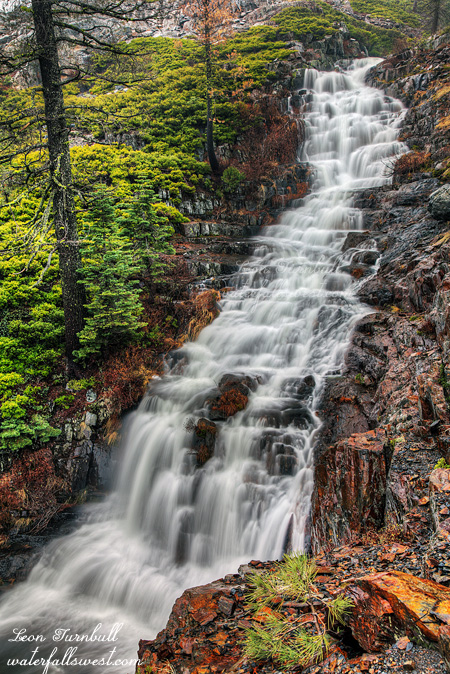
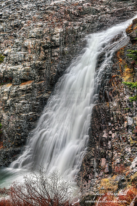
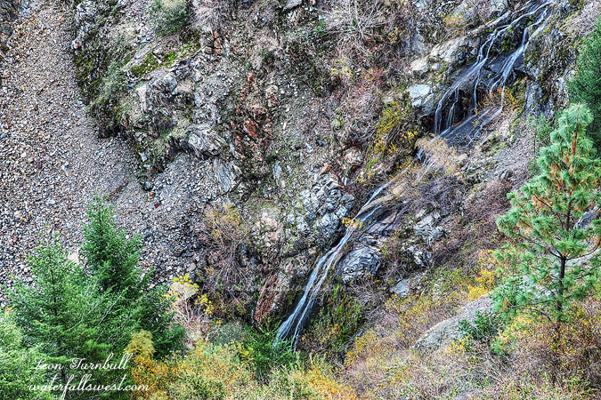
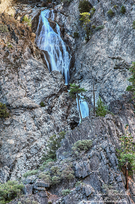
From the “trailhead” at the end of the road (where I would have parked if there had been no mud piles), I descended into the forest. Down down down. 1000 ft. down. From time to time, I caught glimpses of the big waterfall across the canyon, but no viewpoint materialized. There were a couple spots where I would have had an amazing view of it, except for one or two trees in the way. If I could just cut those trees down, I thought. Huh. I kept going down. I was getting close to the cliff. The point of no return if I was not careful. Maybe from the edge of the cliff, there would be an unobstructed view. I came to a particularly steep section and the ground was rather crumbly, and sat down wondering how I could get down. Do I need to get out my rope here? Then I looked beside me and there was a rope. It was as though it magically appeared. I don’t think the bears put that there. Obviously someone had been down here before, but the rope ended and did not go all the way to the bottom. Then I saw it. There was a rock outcrop directly across from the falls, and it looked open. Could I get to it? I made my way over, climbed up onto the rock, and voila, I had my viewpoint. The sun was starting to get into my scene, unfortunately, since it took so long for me to get down there. But I had my viewpoint. It was indeed, basically, right on the edge of the cliff, directly across from the top of Middle North Fork Falls. The picture here is only the top part of the waterfall. The total height of the falls is 231 ft., and the top section shown here is about 100 ft. It continues for another 131 ft out of view. I did find a viewpoint of the entire waterfall, but it was a partially obstructed one. This was the best I could do for this waterfall but this was a sweet sweet place, and even though I couldn’t see the entire falls from here, I was a happy camper. I also got a long distance view of Burnett Canyon Falls, another waterfall in this crazy drainage that is impossible to get to.

Well enough of all that, it was time to head back up the mountain. My back was killing me when I got back to the car, but I survived. I wish I had brought my lunch though, it was noon and I was starving. I was not expecting this hike to take so long. It was an hour drive back to Auburn, where I re-fueled with a triple Western bacon cheeseburger. Yes, you heard that right. Triple. It was a very good day.

No Comments