THE HUNTSMAN

So for Halloween, my daughter Nekoda dressed up as “The Huntsman”, carrying a bow that was much larger than her. Really though she was more of a “huntress”, but she wanted to be called “Huntsman”. Ok, whatever. What does that have to do with waterfalls, you say? Well, let me tell you!

Our first big winter storm of the year came on Halloween, starting right at around trick or treat time. This seemed to upset a lot of people, especially about the timing of it all, and I heard a lot of whining about it. I could possibly understand such thinking in normal times , but we are in the midst of a three year drought, people. The reservoirs are at 30% capacity. If we have another bad winter (and we just might), we will be in a world of hurt next summer. What is more important here, Halloween or rain? It seems rather obvious to me. I was very proud of Nekoda, however, because a couple days before Halloween she prayed for rain to come, even though she knew the storm was coming on Halloween Day. It was a very unselfish prayer (unfortunately, I can’t say my son did the same – haha), but she also had no intention of letting any amount of rain ruin Halloween for her, and she didn’t. Both kids went out trick or treating in the rain, and had a great time.

Anyway on to my story. Saturday morning, I got up early and headed up into the mountains to Emigrant Gap. There was quite a bit more snow up there, more than I expected to see, and it was still snowing, but the road was clear. Many tire tracks had already headed down the road that morning. I was shocked. Normally, I never see many cars on this road. What is going on? Is everyone going to my waterfall? Then it became very clear to me: hunters! It was grand central in Emigrant Gap, filled with hunters, because it was the last weekend of deer hunting season. Ugh. Well, they did clear the road for me, but I was not happy to see so many people out this morning. Especially hunters.

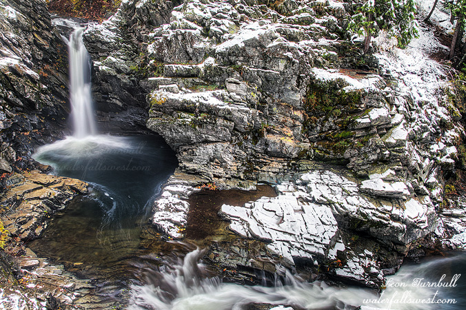
I decided to go down to North Fork Falls first. And a good thing too. I’ve been here in the snow before, but it is a pretty waterfall when there is fresh snow, if you can get there, and the river was quite high, much higher than I expected (and quite a bit more flow than when I was here last year in the snow). Certainly a great start to the day.

My second hike was much more difficult, and unfortunately did not pan out in any new waterfalls. There was just too much snow, and the terrain was too dangerous and slippery with all the snow on the ground. By the time I got back, I was freezing cold, and soaking wet, from my feet up to my hands, but even though I did not get any more photos, it was still a great hike in the snow. About a half mile before I got back to the car, I see a hunter walking up the road. He asked me if I had seen his buddy. I said no. He was very surprised at this. No? Nope, haven’t seen anyone. There was only one set of tracks heading up the road as well, which were mine from earlier that morning, and I pointed this out to him. But isn’t the main road back that way? he said, pointing behind me. Uh no, it is the other way. You are going in the wrong direction, bub. Now, I thought he was going to have a heart attack right there. He was in shock. What? he said. He did not believe me, so I had to show him my GPS and show him where we were and where the main road was. I guess he was off in the bushes trying to find some deer and when he got back to the road he headed in the wrong direction, thinking he was following his buddy’s tracks back to the car, but instead he was following mine from that morning. He said if I had not showed up, he would have continued on forever. Or until he became lion chow. Or whichever came first. Well we walked back to the cars together (his buddy was waiting for him there), chatting about hunting, deer, and waterfalls. It was a fun day in the snow.

5 Comments

THERE BE WATER, BATMAN!

What is this? Water flowing in California in October? In the midst of a 3 year drought? Impossible, you say? Not so Batman!

This is the South Fork Feather River with a flow of 400 cfs. Yes, it is a dam controlled river. And yes, for a short period of time in the summer, there is a recreational release of water from the dam, mostly for the kayakers I guess (but also for waterfall hunters!). Blink and you will miss it, especially in this drought year. I heard about this release from the kayaking community. This is a popular run for them, as there are quite a few rapids and small falls, and then there is this waterfall as well. I decided to make the long drive up here and see if I could get down to this waterfall, which I had never been to before.

It is a very long drive. I remember last year when I went to Deadwood Creek Falls at Clipper Mills, I thought that was a very long drive. Well this was even longer, another 25 miles or so past Clipper Mills, along a very winding road. Ugh, no wonder I had not been out to this waterfall before. But you gotta do everything once, right?

I arrived at the dam at 6:30am, right on schedule. There were already kayakers here, camping overnight, I guess so they can get going on the river bright and early, or something or other. I tried not to wake them, but I think I did wake at least one. According to my calculations, I did not have much time to make it down to the waterfall because it would be in the sun already by 7:30am. And I wasn’t sure exactly how or if I could get down to it. I almost did not make it. My planned route took me to the river a bit downstream from the waterfall. It was rather cliffy down there, however, and I was blocked out from being able to continue upstream to the falls. Hum buggers! I was screwed. It was already almost 7:30am. I would have to climb all the way back up to the top to get around the cliff, then try to work my way back down again right at the waterfall. I did not have much hope of doing that, because I figured it would be far too cliffy there (which is why I did not try that way first!), and by the time I got back down, it would surely be well in the sun. Nonetheless, this is what I attempted to do. When I got to the top and at a location right above the falls, I followed a ridge back down. Surprisingly, very surprisingly, there was a possible route down which would not end up being certain death for me. In other words, it was not as cliffy as I anticipated. I was able to make my way all the way back down to the river, right to the base of the waterfall. And lo and behold, thank the good Lord, it was still in shade. I did not have a lot of time to take photos before the sun arrived on the scene, but it was enough. Awesomeness.

Now about the waterfall itself, I admit I was disappointed in its height. I was expecting it to be bigger. The kayakers claim this waterfall is 30 ft. high. Umm, yeah, not even close, guys. Why is it that kayakers always seem to grossly exaggerate waterfall heights? I wonder. Anyway, this waterfall is not 30 ft. high. I measured it a few different ways, and the most accurate measurement I came up with was 19 ft. That is the best I can do, guys. I cannot even give it another foot to make it an even 20. It might not even quite be 19 ft, but I think I got it right. Certainly, it is not any more than that.

Well I waited around to see if any kayakers were going to grace me with their presence, by dropping over this waterfall. I waited quite a while, but they never showed. Sleeping in? The sun was well up, so I finally headed back up the mountain. When I got back to my car, the sleeping kayakers were all gone, and so were their cars. I guess they were probably on the river yesterday, and not going back down today. I would have been waiting a long time had I stayed down at the falls. There were others that looked to be getting ready but had not started yet. Anyway, I had enough, and I still had that long long long drive back home. It was a fun day on the South Fork Feather River.

2 Comments

GO TO THE FLOW, JOE

I bet you thought there were no waterfalls left flowing in California due to this nasty drought. Right? Well, besides a very select few such as Burney, Mossbrae, and McWay Falls that flow year round, most everything else is pretty much dry no doubt. But not this one.

The North Fork Stanislaus River is a controlled river flow, so I knew that it would be flowing well. The keepers of the water usually have this river flowing all summer long. So when the drought leaves everything else dry as a bone, coming here in the summer is a good option.

I had never been here before, however, and I had been putting it off for three years now. There were a multitude of reasons why I had not tried it before. Number one reason is the very long drive and the fact that I would have to get up at 3AM in order to be able to get down to the river in good lighting conditions. It is SOOOOOO DIFFICULT getting up that early in the summer time and I did not think I would make it this time either. In fact, I had turned off my alarm in the middle of the night, thinking I would skip it yet again. But at around 2:50AM, I was wakened due to my wife snoring. She is not a loud snorer (and she will tell you she does NOT snore – yeah right) but I need perfect quiet in order to fall to sleep. Well, I may as well get up and go, I thought.

I had known about the waterfalls on the North Fork Stanislaus River from the kayakers. The Devils Kitchen run is a popular one for them, so I am certainly not the first to document/discover these waterfalls. I had thought, though, that I might be the first to hike down to them. I certainly have never heard of anyone hiking down there before. So in a way this was another drawback for me. I was not sure if it would even be possible to hike down to the waterfall due to very steep terrain or thick brush. Even if I could get down to the river, would I be able to get any view of the waterfall? Also, I did not know exactly where the waterfall was on the river, though I had a good idea, and I also thought it might not even be 20 ft. high. A huge long drive and a big difficult hike for a 15 ft. waterfall? Not exactly something at the top of my list of things to do. But alas the stupid drought does not leave many other good options, so this one still seemed like a good plan to me.

There actually was a trail down to the river, so I suspect I am not the first to hike down there. Well, it is an extremely old trail, and very faint, too faint to even follow in a lot of places. It has certainly fallen into disrepute and probably not been used in a great many years. Except it IS still used … by bears. There was a very large amount of bear poop along the trail, and some of it was HUGE. Like so huge I think there must be grizzly bears down there or something. I cannot confirm that though. I did not see any. I did not see any black bears either. Just a heckuva lot of poopage.

Even though the trail was too faint to follow, the terrain was not too steep and not too brushy, so I was able to make it down to the river. From there I worked my way upstream and found this waterfall. The kayakers call it Portage 24, and I measured it to be 34 ft. high. I was very pleasantly surprised to find this beauty and to be able to get down to it without too much difficulty, and especially that it was bigger than 20 ft. high. There is another 25 footer shortly above this one, though not as nice, but I will share that photo later. The lighting was not very good for photos, however. Even though everything was in shade, the sun was getting ready to come up over the ridge in the distance, making everything a bit too bright. In another month or so, the sun would be at a much better orientation for morning photography, however, I am not sure it will be flowing in a month, as the water gurus will likely turn the tap off by then. It is a beautiful place, and I would like to go back someday, but the hike back up the mountain was killer, climbing 1500 ft. elevation back to the car. And then that long drive home. Whew!

2 Comments

ONE LEFT

Horsetail Falls is THE waterfall I love to visit in the summer. This 790 ft. monster waterfall always has good strong flow in the summer, and this year, it is pretty much the only waterfall left around here that is still flowing at all.

As I drove up Hwy 50 on Friday evening after work, I saw that the South Fork American River looked pretty pitiful. It seemed much lower than just a week ago when we drove up to Tahoe. This was bad news. Since Horsetail Falls flows into this river, I had no doubt the waterfall would be pitiful also. Well, not so, actually. In fact, it seemed that Horsetail Falls had quite a strong flow still. I don’t really understand how it could be that Pyramid Creek had a bigger flow than the American River. Makes no sense, but perhaps it was just my imagination. Anyhow, I paid my parking fee and marched up to the falls.

When I arrived, I found a couple different people enjoying the view at the base of the falls. This is not allowed. I am the only one that is allowed to be here on a Friday evening. Just kidding folks. But it is surprising because usually I am always alone when I come here in the evenings. Well, I explored a bit further up the mountain this time, but did not find any interesting photo spots, then came back down, and by that time, the others had left, so I had my favorite spot to myself (actually, I have a few favorite spots at Horsetail Falls). This is definitely not a new composition for me but it is all I got this time around. It seems that I stupidly left my image stabilization ON, and I did not realize this until I got home. When you do this combined with using a tripod, your images are ALL blurry. Well, I managed to scavenge this one photo which is not too horrible, but it would have been much sharper had I not been so stupid. Anyway, at least I only did it at this easy to reach waterfall, which I have already been to a hundred times, and will return again many more times. The only other time I left the I.S. on was at a waterfall in which I will likely never return to again because it was so difficult, and I did not get any good pictures of that one.

I will probably be back to Horsetail Falls again very soon. I have one more idea for a new composition of this waterfall (IF I can get to this one particular spot which I was eyeing on Friday – and not kill myself in the process). The flow is definitely on its way out. In another couple weeks, you will be able to cross the creek easily at the base of the falls; I could have almost done it this time, but decided to play it safe. That’s a good thing.

No Comments

MORE BLUES

The more I look at this photo, the more I like it. This is the upper tier of Upper Blue Canyon Falls at Sonora Pass. It is 36 ft. high. The total height of the falls is 77 ft.

I came to the bottom of the beautiful falls, but there is not a good view of the entire waterfall, at least I did not see a good one. After shooting the lower tier, I climbed up beside the waterfall to the upper tier. It is a wonderful place to be. The entire canyon is beautiful, and I think I will want to come back here sometime and explore some more.

No Comments