I’ve been slow in sharing my Sonora Pass images on purpose. I have to make them last all summer. It is going to be three more months before we get rain (hopefully less though!), and I have not many photos left to share this summer. Ah well, do not worry, I will not make you wait three months before all of these Sonora Pass images are shared. In the meantime, I am getting excited for next season. I have been busy mapping out new hikes and searching out new waterfall possibilities, and I have some epic ones lined up to go find. I just pray God will oblige me this year. Or rather, that He will oblige ALL OF US. Another year of drought will be a nightmare for everyone in California.
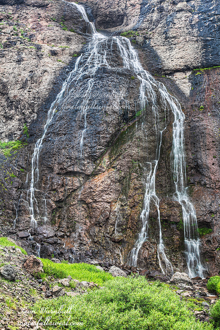
Speaking of epic waterfalls, this is one I definitely hope to get back to next spring when it is flowing well. Even at low flow this was an awesome 120 ft. high falls. In fact, I think this might be my best waterfall find of the entire year. I thank my Flickr friend Philip for first alerting me quite a while ago to this waterfall on North Fork McKay Creek, right beside the popular Sardine Falls. If I had known how awesome the waterfall is, I would have made it out here much sooner. I wasn’t actually planning to come here this time either, as I figured the creek would be completely dry. However, the rain picked up all the streams in the area, and I thought I should try it. I am so glad I did.
After my Blue Canyon adventure, I drove up to the Sardine Falls trailhead. Someone had forgotten their car keys at the trailhead, and they were hanging on a post there. And you thought I was bad by forgetting my water on my hike at Blue Canyon! I just wonder how they drove their car away without their car keys? Hmm, well anyway, it is a simple little hike up to Sardine Falls. I could see it flowing decently well in the distance. When I got to North Fork McKay Creek, I found that there was flow in that smaller creek as well. I found a trail (or more like a path) on the far side of the creek and up I climbed. It is a 650 ft. climb in elevation from the trailhead. Nothing too difficult. Except for that darn elevation. The base of the waterfall is at 9400 ft. elevation, and it really killed me getting to it. It is probably twice as difficult to make a 650 ft. climb at 9400 ft., then say at 5400 ft. elevation. That is my highly unscientific analysis. But I am sure it is true.
Since it was taking quite a while to hike up the creek, I was wondering if it was such a good idea to continue. I wasn’t sure anymore if I had time to make it up there and back before dark. I also had to photograph Sardine Falls, and I was hoping to get to Leavitt Falls as well before dark. It seemed that I still had a long way to go up the canyon, and I wasn’t getting closer fast. Not to mention that I was dying from the elevation. But I persevered. Finally, I came around the last corner and let out a humungous WHOOP! Wow! North Fork McKay Creek Falls is an utterly spectacular 120 ft. fan shaped falls, and at this location you are up so close and personal. You can even get right up to the base of the falls if you desire. It is a tremendous beauty, and I definitely want to come back here again.
Posted in Northern Sierra, Waterfalls by leapin26: July 30, 2014
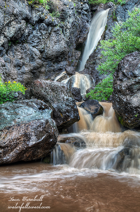
The storm was clearing out when I finished photographing the lower muddy Blue Canyon Falls. What should I do next? It was still early in the afternoon so I decided to climb back up into Blue Canyon. I had my tripod with me this time, but instead of that I forgot three more items back in the car: water (again), my hiking boots, and my GPS. I’m not sure what my problem was today! The high elevation must be getting into my brain! Well, I did not feel like climbing back up the hill to the car to get any of those things, and I figured I would not need any of them, so off I went up the mountain. It was actually nice to just wear my water shoes, because I had to cross the creek a few times on the way up and back down.
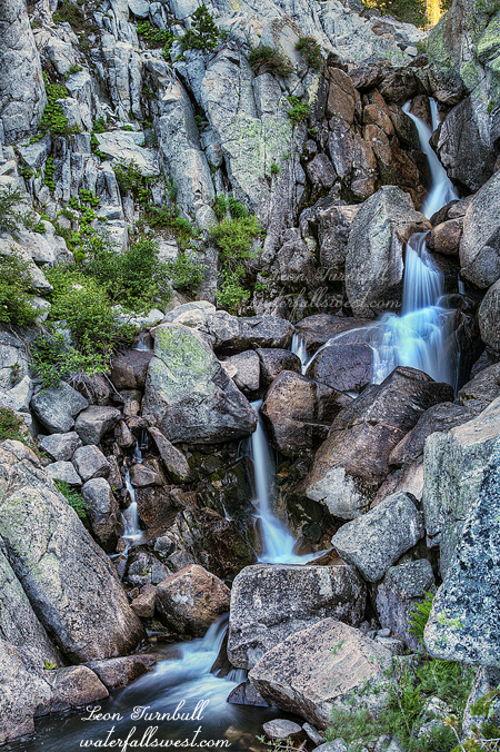
I shortly came to the first waterfall (again), this time armed with my tripod and ready to photograph it properly. This one is a brand new waterfall and not one I expected to find here. I like surprises! It is possible that I even might have missed it had I hiked on the other side of the creek (where the “official” trail is). It is tucked away in a small gorge, but it is a little beauty, 33 ft. high. I am calling it Middle Blue Canyon Falls, and I think it is by far the prettiest of the three waterfalls on this creek.
The birds were chirping away, and I figured that must mean the storm was all done (I’m sure they know the weather better than humans), so I continued upwards and onwards to the next waterfall in Blue Canyon.
Posted in Northern Sierra, Waterfalls by leapin26: July 23, 2014
In a desperate search for water, I sought out Sonora Pass this weekend. Most everything in California is dry now. The mountains in the Tahoe area are devoid of snow; they usually carry snow until late in the summer. The Sonora Pass mountains are quite a bit higher, so perhaps maybe they still had some snow. They did not. But I definitely picked the right day to go there.
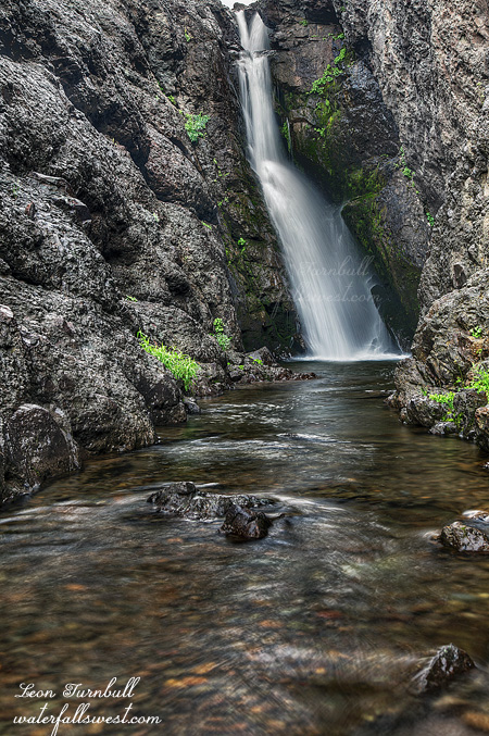
When I arrived at Blue Canyon I found the creek was flowing high and muddy from the day’s thunder storms. Flash flood? More like flash mud. It was kinda weird actually. All the muddy water was coming down from a small side stream that was no doubt completely dry yesterday but was raging with muddiness today. Blue Canyon creek proper was clear and flowing nicely. I was unsure if Blue Canyon creek was also up because of the rain or was this a normal flow? If it was up due to the rain then why wasn’t it muddy also? So many questions. I had wanted to climb up into Blue Canyon but I wasn’t planning to do it until the next morning. With the flow up though, I decided to change the plan. Who knows what it would be like tomorrow.
I crossed the muddy stream below the lower falls and climbed up into the canyon. I felt something was wrong, that I had forgotten something back at the car but I could not think what I had forgotten. Oh well, it can’t be that important. I quickly realized one thing: I forgot to bring water. That didn’t seem like that was it though. Water is important but it was a short hike so I was not concerned about that. When I arrived at the beautiful upper falls (which was not really the upper falls – more to come about that), I realized the other thing I forgot: my tripod! Doh! Now that is important! I tried taking some shots hand held but it was no good.
By this time I heard the thunder. Another storm was rolling in. I don’t care about rain but I sure did not want to be caught up on the mountain in a lightning storm. Yet I did not see any lightning anywhere. How could there be thunder and not lightning? That makes no sense. It is not even possible! Well, I decided to go back down the mountain. It was pointless to continue up the mountain without a tripod anyway, and I’m sure it would have been stupid in the storm. By the time I got back down to the car it was pouring rain. Still no lightning. I did not leave yet though because I wanted to get a shot of that muddy falls. However, by the time the rain had dissipated, the waterfall was much less muddy than it was when I arrived. That side stream was now almost dry again. Well, I went back down to the creek, crossed the muddy stream again and took some shots (with my tripod!). It was quite nice, and only slightly muddy. Now what should I do next? Stay tuned to find out.
Posted in Northern Sierra, Waterfalls by leapin26: July 18, 2014
I continued upstream from Upper Cascade Falls. Surprisingly, there was a pretty decent trail. It was hard to follow in places, but overall quite decent. Considering that this section looked rather brushy on Google Earth, I was pleased. The trail took me right through all the brush easily. It did, however, meander all over the place, weaving in and out of the brush, across streams, and through the forest. Yes, the forest was interesting. It was late in the afternoon now, and the light in the forest was getting dark. Gloomy dark. Menacingly dark. The trail was quite overgrown through the forest. I was afraid I would be ambushed by a Sasquatch. There were only mosquitoes.
Finally out of the forest, and I could see the waterfall ahead, dropping down from Azure Lake. It took much longer than anticipated to get up here. And now time was my enemy. Sunset was approaching rapidly. I made my way over to the base of the falls. The waterfall is 46 ft. high but it is difficult to view it from the bottom. The angle is wonky and extreme. I looked around but I could see no other viewpoint available, so I did what I could, but I was not happy with this one. I decided to try to climb up to the top of the falls. I estimated that I had two minutes to climb up, get a photo, and start hiking back to the car. Otherwise, I would be hiking back through that forest in the pitch dark. Sasquatches abound in the Desolation Wilderness (and mountain lions). The trail continues from here up to Azure Lake, so there was a good path. Once up there, I found a huge rock that you can walk out on where I found an excellent viewpoint of the upper tier of the waterfall. I was out of time, but the view was worth it, so I quickly got out my camera, and walked out to the end of the huge rock with deadly drop-offs on either side of me. It is such a very pretty view and waterfall. I will definitely be back up here someday. I was about 10 minutes late starting back down, but I made it back to the car just as it was getting dark. The timing was perfect.
Posted in Lake Tahoe, Northern Sierra, Waterfalls by leapin26: July 2, 2014
After running out of daylight last week, you know I was going to be back here again the next weekend. I was anxious to get to the upper tier of this waterfall while it was still flowing. I think it would have been better last week, though. I estimated the flow in Cascade Creek was about 3/4 of the flow from the previous week. It was still ok, but this upper section especially would look much more impressive with more water flowing in the creek.
I had a big agenda again for my hike this week, and the timing would be paramount. I hiked straight to the upper falls. I made nary a glance at Cascade Falls as I hiked by it, continuing on to the Upper Cascade Falls, and completely bypassing the lower tier. I crossed the creek, and climbed up the granite slope and back over to the upper tier, where I found a great viewpoint as I expected, though it was slightly tricky to get over to it. You don’t want to be sliding down the slick slope to the bottom, if you can help it. That might hurt. I measured the upper tier to be 37 ft. high, exactly the same as the lower tier. Go figure. As I said, it would look pretty amazing at higher flows, but will I be able to cross the creek (twice) at higher flows in order to get here? I will definitely be trying it someday in the future. Not this year, obviously.
After shooting the upper falls, I continued my hike up into the wilderness where I found yet another waterfall. It was a pretty one indeed, and I will be sharing that post next. You won’t want to miss it. It did take a bit more of an effort than I expected, so it was a good thing I was quick getting to Upper Cascade Falls. I made it back to my car just as it got dark. Perfect timing. It was a great hike into the Desolation Wilderness.
Posted in Lake Tahoe, Northern Sierra, Waterfalls by leapin26: June 28, 2014
