Wake up 3:30am. Drive to Feather Falls trailhead. Arrive in dark. Start heading out to the waterfall.
Sound crazy? Nuts? Insane? Wait til you hear the rest of the story.
First off, this may be TMI but when I arrived at the trailhead I had to use the outhouse facilities there. I noticed a rat crawling around down in the hole. I’m not kidding you. Needless to say I went very quickly.
That was the freakiest thing I saw this day. Which is probably good because I was biking in the dark. Not hiking. I was hoping to be at the falls by sunrise and since it is about 5 miles one way, biking is the quickest option. It is actually a very nice trail to bike, going out is mostly downhill, but fairly gentle, so coming back afterwards is tough but not killer. It is easier to hike out and back but much quicker to bike.
I was also trying out the new camera I just bought. A GoPro Hero head cam. Why would I get such a thing? Well, I have a grand idea of documenting my hikes for the public to view and follow me along. This one is going to be really good I think and definitely not boring, so be watching for it soon.
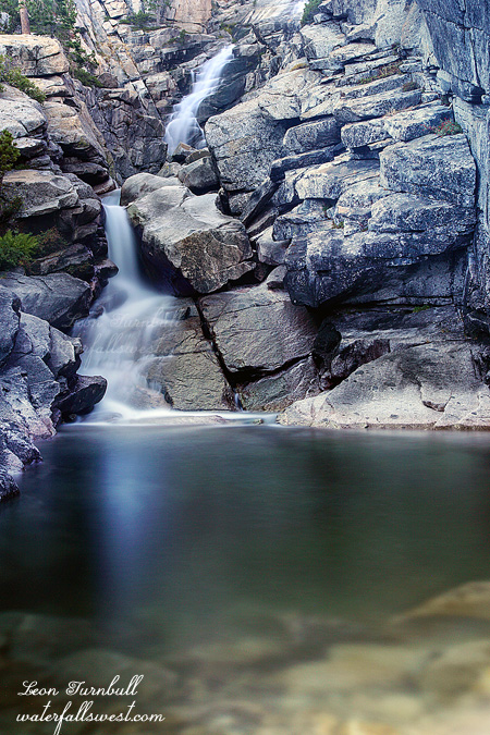
I arrived at Feather Falls a bit later than I wanted. I first went down to the viewpoint. The falls was flowing really quite well, much better than I expected. This late in the year and after two years of drought I thought it would be as low as I have ever seen it. Not so. It was exquisite.
After photographing from the viewpoint it was time for part two of my adventure: crossing the river above the waterfall and try to find a spot on the other side to photograph it. I have never seen a photo of Feather Falls from the other side. Now I know why. (actually I lied – I have seen one very very old photo, but that is it).
I figured the worst part by far would be crossing the river and with the falls flowing higher than I expected, I thought it might be impossible. People have died here including one last year. It is kinda freaky crossing a river above a 410 ft high waterfall but actually it was very easy (don’t try it in the spring though).
Next up was to climb the ridge on the other side and make my way down to a point where I could see the falls. After studying Google Earth I really expected this to be a piece of cake. It looked so open and non brushy. Not quite. It was extremely brushy. I found a trail going in the right direction and thought I would be in luck. At first I thought it was a human trail but after awhile (and after passing a number of bear droppings) I realized it must be a bear trail. Eventually I was stopped by the brush. I could go no farther but I did get to a point where I could see the waterfall. It was too obscured to take a picture but you will see it in the video. So it was not a huge success but at least I got a view of the waterfall (albeit somewhat obscured).
The bike ride back to my car was quite tiring (it didn’t help that I did all that scrambling on the other side of the river). All uphill and 5 miles, but I made it all the way. It is a good thing I am in shape right now from biking to work every day. Otherwise I might still be out there on the trail somewhere.
Posted in Northern Sierra, Waterfalls by leapin26: October 27, 2013

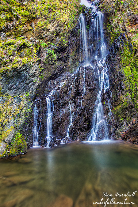
This is yet another of the many marvelous waterfalls in the Rainbow Pool area that was recently ravaged by the Rim Fire. This is the third waterfall on the South Fork Tuolumne River, plus the one on the Middle Fork makes four waterfalls in this one location. Such an amazing place. And hopefully it still will be. I measured this falls to be 26 ft high, though it seems a bit smaller to the eye when you look at it. The first time I was here last year, I missed this one because the road was blocked by a huge landslide. The landslide was happily cleared away this year and I could get down to this little dude. Sweetness.
Posted in Northern Sierra, Waterfalls by leapin26: September 3, 2013
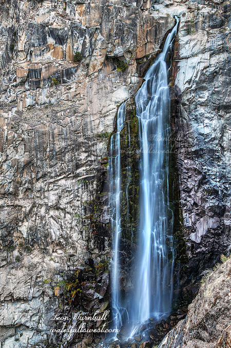
If you know this location and if you are looking closely you may be wondering how this image was taken. You should be wondering. It is an impossibility. Well, not really. I guess that is obvious. But in reality, for most of the year it *is* an impossibility.
My goal was singular. Cross Pyramid Creek at the bottom of Horsetail Falls and photograph the waterfall from the other side. I have been thinking about doing this for a long time now. For such a long time, that my brain began to hurt. As far as I know, no one has done this before. At least, I have never seen any images from the other side before. For most of the year, Pyramid Creek is rushing too swiftly. It is simply impossible to cross the creek here. If you want to live, that is. When I was here three weeks ago, the creek was still just a tad too swift to cross. I think I could have done it, however I decided to wait just a tad longer. I should have done it earlier.
Fast forward three weeks, and I decided to try it again. The difference was astounding. During those three weeks, Pyramid Creek lost more than 50 percent of its flow. No exaggeration. What happened? How could it have dropped so much flow in such a short time? I was shocked. Indeed, as I hiked up to the waterfall, I anticipated that I might not even need to get my feet wet crossing the creek. And as it turned out, I did not need to. I arrived at the base of the falls and saw that I could rock hop across to the other side. There is no way I could even come close to doing this three weeks ago, but today it was easy. The waterfall flow clearly was not very exciting, so I decided to do more experimenting with another really long exposure – this one is 120 seconds. If I had been able to cross three weeks ago, the waterfall image would have been much more impressive. I just waited a bit too long to try this but now, I will have to wait until next year to try it again. I will not be back to Horsetail Falls this year.
Speaking of next year, the early reports are not looking too promising. It seems we might be looking at another weak El Nino, the same as last year. That could mean another dry winter for us. It is too early to know of course, so let us hope this is not the case. Start praying now.
Posted in Northern Sierra, Sacramento, Waterfalls by leapin26: September 1, 2013
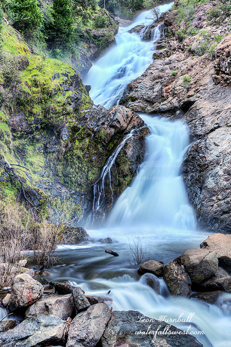
This is the Lower Middle Fork Tuolumne River Falls. An incredibly stunning 182 ft. high waterfall (and before last year, was almost completely unknown). This image was taken back in the spring though I had not posted it before now. It is located in a spectacularly beautiful area with three amazing waterfalls practically side by side. At least it was a spectacularly beautiful area. Is it still? Of course it is! Nevertheless, this area has been hit hard by the Rim Fire, one of the largest fires in the history of California. It will certainly be interesting to go back here after the fire is done, and see how the area has changed. It will undoubtedly be significant.
It seems that a lot of people are upset by this fire. So much more so than any other fire I remember. Yes this area will be different now. For better or worse I don’t know. Fire is a natural and necessary part of the ecosystem. Fire is not a bad thing, but yes there will be a lot of damage. The fire is much bigger than it should be, and there are many factors why. Nonetheless, the waterfalls will still be there. The lakes and rivers will still be there. It will still be beautiful. As for myself, I’m looking forward to going back to this area.
Posted in Northern Sierra, Waterfalls, Yosemite by leapin26: August 27, 2013
Well this was certainly a fine and pleasant surprise. And not exactly what I had planned either. Or rather not at all what I had planned.
My objective for Friday evening was to go back to Fordyce Falls. PG&E still has Fordyce Creek cranking out at 450 cfs. I’m sure any day they will turn off the faucet, so I wanted to get out there before that happens. Unfortunately there just happens to be a little forest fire in the area. A big one, actually. The American Fire is raging in the North Fork American River Canyon near Foresthill. Fordyce Creek is up near the top of the pass at Yuba Gap, so it is not exactly in the same area but the smoke is hovering over the pass. It was really quite a sight to see driving up I-80. There is a huge mushroom cloud ominously stretching out across the sky. The light is strange, and the color is remarkable. The hike to Fordyce Creek begins at Fuller Lake which is on the edge of the cloud, so I would be hiking right into that looming disaster. I really felt it would be unwise to make an 8 mile hike through all that smoke. It did not seem too bad at Fuller Lake, but to hike 8 miles through the midst of it would be extremely unhealthy. It would probably be like smoking 10 packs of cigarettes all at once. I’m not a smoker, not even for a waterfall. I decided to go back.
But I wanted to do something. After all, I drove all the way up here. I thought maybe I could go for a hike back in the Colfax area. I remembered this waterfall I had heard about on Osita Creek, so I looked up the directions on my iPhone. It is an easy hike, the weather was very warm, and the bugs were obnoxious. I had absolutely zero thoughts of seeing a waterfall here. I was certain the creek would be bone dry, I was only wanting to scout it out for the winter. Essentially, wasting time because I needed to go on at least one short hike.
I had read that this waterfall was only 20 ft. high and that it was man-made. This is the main reason I had never been here before. I had no desires to see any small, man-made waterfall. Boring. Well, I had three fine surprises in one: the creek was flowing half decently of all things, it is much more than 20 ft. high, and it is *not* a man-made waterfall. I did not bring my measuring stick so I am not sure exactly how high it is. Normally I always carry my tape measure (I mean, laser rangefinder) but this time I was not planning to go to any new waterfall and I was trying to save as much weight as possible for a 8 mile hike to Fordyce Creek. Bummer. I estimate though that this waterfall is at least 35 ft. high, perhaps closer to 40 ft. That is about twice the height I had read. Usually when someone says a waterfall is 20 ft. high, it is much less than that. This time it was the opposite. Weirdness indeed. Also, I was happy to find it is not man-made at all. It does flow through a man-made tunnel under the canal at the top of the falls which is unfortunate and detracts from the beauty, but it is still a natural waterfall. As for the flow, I was just shocked to see it so decent in this dry year. Still though, it will be much better to see it in the winter, and I for one will surely be back here.
Posted in Northern Sierra, Waterfalls by leapin26: August 17, 2013
