Big Mosquito

It is coming. Maybe. I hope. Perhaps. I’m talking about snow of course. We are still waiting for winter to start here in northern California. The last report I heard is that it is on its way. Mid January things will start to look up. I hope.

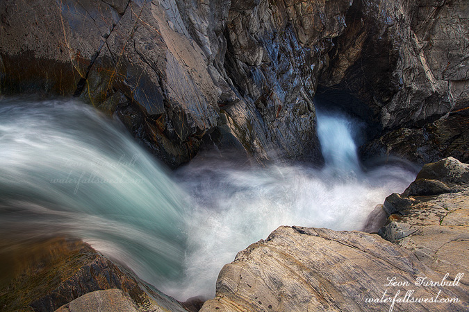
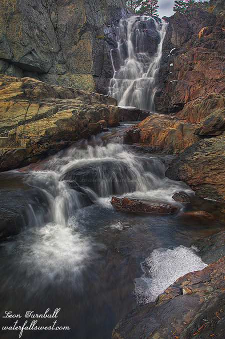
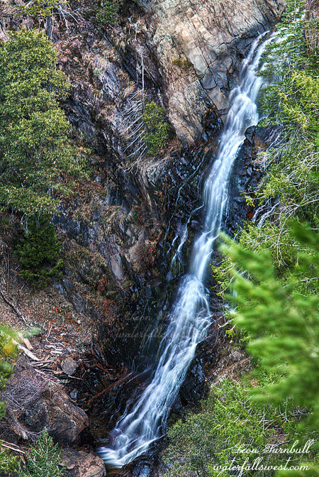
In the meantime, I ventured out to Foresthill looking for a new waterfall on Big Mosquito Creek. With an ominous name like this, I don’t think I would want to come here in the summer. I did not think it would be flowing greatly, but it was more of a scouting trip to return to in the spring (before mosquito season, hopefully). I found the waterfall pretty easily, the viewpoint is just off the main road. Getting down to it is another matter entirely. I did not try this time due to sore ankle and lack of water flow, but I think it is possible, and when I return back in the spring I will definitely give it a go. Another reason I must return is that I am not very happy with this photo. I did not get it in good focus for some reason. Was my I.S. switched on unawares? I did not think so. Ugh. Well, if we do get some snow, then this creek should have great flow in the spring, and the waterfall will be rockin.

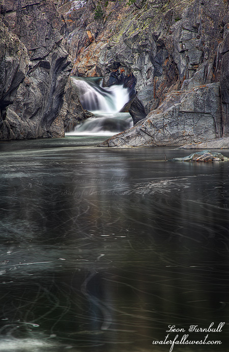
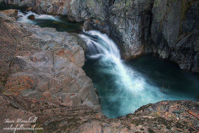
Waterfalls, actually. Yes, there is almost certainly a second, much larger waterfall on this same creek downstream. Unfortunately, I think it might not be possible to get down to it. It is about 2 or 3 miles downstream from the upper falls, and after taking a gander at this upper falls, I ventured downstream seeing how close I could get to it. With my ankle still being sore, I did not really want to go too far. Indeed, I went further than I should have, but the going was actually pretty easy and the forest was pretty open, as I think there was a fire that went through here many many years ago. But further down it starts to get very cliffy and that is where I turned around, still a good two miles from the waterfall. From where I turned around, it would have still been possible to continue. But for how long, I do not know. On the way back up, I came to a strange open, flat area. It seemed there was a lot of old bear poop scattered throughout the area, and bear trails going off in different directions. Was this where all the bears in the area hung out? Or slept? Then I heard a strange sound, like a horse. (but obviously, it was not a horse). I do not know what it was, if anything. Maybe a bird. But maybe it was a bear turning over in its sleep. I did not see anything. But I sure did not want to wake up a sleeping bear, so I scooted back up the hill as fast as my sore ankle could take me.

No Comments

How Close Do You Dare To Go?

Emerald Pools Take Three.

This weekend they were still releasing water from Lake Spaulding into the South Yuba River so I took one last trip up to see the Emerald Pools on Sunday afternoon after church. (and as it turned out, on Monday morning the faucet was turned off; I got to see it on the last day the river was still running).

I wanted to get down to the lower Emerald Pools on the north side of the river this time and try to get a decent shot of the falls from there.

Along the way I stopped off at the Upper Emerald Pools to attempt to locate my sunglasses where I think I must have dropped them. Could not find them. Bummer.

Continuing on, I made it down to the brink of the lower falls in short order. My goal was to photograph the lower tier of the falls from the north side cliffs (which I did) but what I found much more intriguing was the view looking down the falls from the brink of the upper tier. Incredibly cool. It was actually easy to get right down beside the falls. I got over as close to the edge as I dared (which was pretty close), sat down on the rock, and setup my tripod. The biggest thing I was worried about was dropping my tripod/camera over the brink, but I kept a very tight rein on them. It was quite an exciting location. After this I went along the cliffs to get a good view of the lower tier, then took a shortcut back to my car on Bowman Rd., making it back home by dinner time. It was a great Sunday afternoon.

3 Comments

Emerald Again

I took a lot longer photographing the lunar eclipse than I anticipated or wanted. My plan was to leave by 6:30AM and drive on up I-80 right afterwards to Yuba Gap, and back to the Emerald Pools. I ended up leaving 30 minutes later than that, and that was after stopping at Starbucks to refuel. I thought about just going back to bed, but according to my calculations, the sun would not be hitting the Emerald Pools until 9AM or 9:30AM, and so I figured that would still give me plenty of time to get there. And it did.

If you remember my last photo of Emerald Pools, you will recall I could not in any way get down to the bottom to photograph the waterfall from below. My intent this time was to approach the falls from the other side of the river. It looked quite steep from the other side, but do-able. As it turned out, it was actually fairly easy to get down, though it did take longer than I expected. I ended up following what appeared to be a mountain biking trail in recluse, abandoned to the elements, or at least to only the occasional summer hiker. It followed the river downstream for awhile, then turned away from it, and seemed to end along Bowman Rd. At that point I went cross country, making my way back to the river, and then down the steep hillside to the river. I ended up exactly where I wanted to, at the bottom of the Emerald Pools, with a great view of the two tiered waterfall that I could not get from the other side. I got two super nice photos of this place, and I could not decide which one I liked better. I’ll probably share the other one later, but this one is more of a closeup of the falls. It perhaps looks a bit bigger than it really is, but it is precisely 20 ft. high, the upper tier 15 ft, and the lower 5 ft.

After shooting Emerald Pools, I went down river a ways more and found a really interesting 30 ft. high waterfall, but with too much sun, and no way to get in position to photograph the waterfall in any respect, due to the cliffy terrain. I know there are even more waterfalls on the river below this one, but the gorge gets crazy steep in very short order. Only kayakers can get down there. Or maybe not.

2 Comments

Emerald

This last Saturday I went to check out Emerald Pools on the South Fork Yuba River. Finally. It has been on my list for a long time, but rather low on the list, and I just had not found the time to get out there. But here in December, I learned that the river was flowing right now, as they are letting water out of Spaulding Lake for some reason or other. How did I know this? By checking dreamflows.com, an excellent resource, used mostly by kayakers, but quite useful for waterfallers as well.

I had planned to go in the morning, but with getting zero sleep the night before, I decided in the middle of the night to skip that plan, and go in the afternoon instead. I arrived about 2pm, and with sunset being so early, that did not leave a lot of time for exploring. Fortunately, I found the river already in shade. Perfect for photography purposes. There is a bit of a trail following the river downstream, and so I followed it, weaving this way and that way, over and around rocks and cliffy sections, until I made my way down to the location of the Emerald Pools. It would have been much quicker to cut straight across instead of following the river path, and that is how I went back. Easy smeasy.

At the Emerald Pools, I came to somewhat of a deadend. There was no way down to the bottom. I was a bit surprised, as it is a popular place for swimming in the summer. How do people get down there? The only way I figured possible would be to go quite a ways downstream, past the cliffy section, work your way down to the river and then back upstream to the pools. It would also be necessary to cross the river in order to see the falls (or swim up to them), and that might be easy in the summer, but it was flowing a bit too swiftly for me to cross today.

Instead of doing that, I tried to make my way down the cliff to get in a position to see the waterfall. It was very tricky. The slope was on the steep side, and very crumbly. I thought I might just slip and slide all the way down the cliff and into the river. There was also one big step down that I needed to make, it was definitely on the edge of my comfort zone, but I carefully carefully made it down to a viewpoint where I could see the upper falls. There are two waterfalls here, and the total height is about 25 ft. The first one is 15 ft. high (measured), though it may not look like it from this angle. The second one immediately below this is about 10 ft high, but I could in no way, shape, or manner, get to any place to view it (and I did try). But as I said, you’d have to go way downstream, cross the river, and back up on the other side, where I think you could view the falls from there, but you’d only be able to do this in the summer when the river flow is much lower. It was getting late though, and I had to get back to my car. By the way, if you see any yellow sunglasses down here, they are yours truly.

No Comments

Upper Glen Alpine

This is Upper Glen Alpine Falls, 32 ft. high. In the spring, it is a little spitfire, roaring down the canyon. But in the Fall, it is actually still quite a pretty little waterfall. Since it is pretty much a straight drop, it does not need a lot of water to look good, so even with very little flow in the creek, it is still lovely to visit. Compare that to Lower Glen Alpine Falls, which was not even worth seeing (on the same creek with the same amount of water flow). It is also quite easy in the Fall to get right down in front of the waterfall in the middle of the creek; I would not be able to shoot from here in the Spring, that is a certainty.

No Comments