
Although I had initially hoped on doing this hike Fri evening, I could not as I arrived too late. But since this was my primary goal for the weekend, I thus had to stay around until Sat evening to do this hike.
There were tons of people at Kennedy Meadows. I could not even find a parking space near the resort and trailhead. I went back to the ” trail” parking area (which is nowhere near the trailhead) and parked. It was early and I was very tired so I tried to take a nap, but it was far too warm to do that. I went out to a picnic table where it was cooler and lay down for about three hours, listening to the nearby campers playing Yahtzee. It was a boring afternoon but still far too early to start hiking. Finally I ate my dinner and drove back down to the resort where there was one (and only one) parking place.
There were many people on the trail and lots of people fishing. I never knew this was such a popular place. But the worst thing by far was all the horse crap on the trail. This is my number two pet peeve (number one is why horses can go on trails in parks but dogs cannot). Horses are far worse than dogs. And why can’t horse owners pick up their crap? Dog owners do. I really really do NOT appreciate having to walk through horse crap on my hike. And this trail was by far the worst I have ever seen. It was constant crap the entire hike (not kidding). Despite this annoyance it was certainly a gorgeous hike along the Middle Fork Stanislaus River. It had an incredible glacier blue color that I have only seen before in British Columbia. It was so beautiful I had an overwhelming urge to jump in for a swim. Of course it would have been far too terribly cold for doing that.
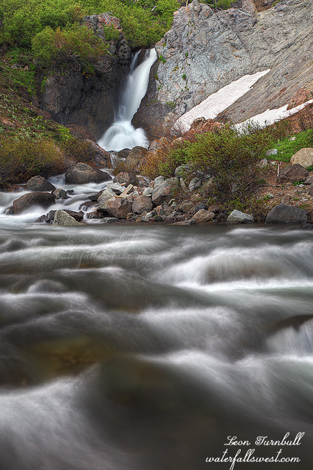
The trail climbs easily up to the confluence of Kennedy and Summit creeks where we find two waterfalls. I went first to Summit Creek Falls which was in shade and flowing beautifully (shown above). Unfortunately I was not alone. Another photographer came by taking pictures of the waterfall. I must say I do prefer having my waterfalls all to myself and usually I plan it so this is the case but this trail is just too popular for that.
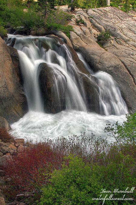
I zipped on back to Kennedy Creek Falls but it was still in sun. I estimated that I would have to wait at least one perhaps one and a half hours until it came into shade, and I would be hiking back to the car in the dark. Normally, I would have done this, but I was far too tired to wait and I still had a very long drive home. I did wait around for awhile though and I think I got lucky as some clouds passed in front of the sun, so I may have gotten a decent shot of that falls after all.
More info on Summit Creek Falls:
http://waterfallswest.com/waterfall.php?id=715
Posted in Northern Sierra, Waterfalls by leapin26: July 31, 2011
I pulled off the highway onto an unmarked road near where I would be hiking the next day. As usual I slept awful. Of course, I had to get up at the crack of dawn. Ugh.
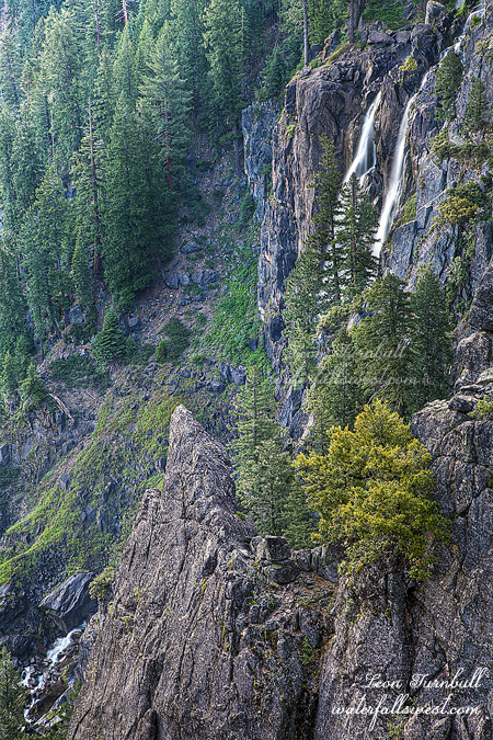
In the morning I drove a bit more down the road to its end and started hiking. No mosquitoes. That was a good surprise at least. I was looking for a great viewpoint of Niagara Creek Falls, a spectacular 700 ft high waterfall dropping into Donnell Lake but it is extremely difficult to get a good view of it. I had seen a photo that was taken from a certain ridge where it seemed a great view of the falls was a possibility so that was my goal for the morning. The hike was much more difficult than I imagined and it did not help that I went the wrong way, first climbing up two faux ridges that had no view of the waterfall. I could see the ridge that I wanted to get up on but it looked too steep to scale, nonetheless I made my way over to it and actually found a perfect little path leading up the cliff. I now had a very good feeling and thought I was going to make it, but then I came to a dead end with only about 100 ft to go to the end of the ridge. There was a 10 foot dropoff followed by a deadly and narrow knife edged path to the end that was blocked by a tree and bushes. Oh crap! I came so close but it was just not close enough. I know that at least one person has made it through here before, but how? It looked impossible. And of course, as you no doubt know, I abhor those deadly dropoffs, so I decided to play safe and just shoot the partially visible falls from this location. It was a “smart” decision but I was totally bummed and depressed about this for the rest of the day. But how could I have continued?
After this I went on a second hike on the far side of Donnell Lake looking for another waterfall. I struck out on that as well but I could see Niagara Creek Falls from the other side of the lake. It was a bit too far away from where I was but it did seem possible to perhaps get much closer to it. It would be a tough hike though and it will have to wait for another year. I certainly did not have the energy on this day. I was getting ready to hike back, but as I was stepping down off a rock I stepped into a hidden hole. It could have been much worse and I suppose I could have a broken leg from it but all I got was a scraped up leg and a severe cramp. I had to lay down on the ground for about five minutes until the cramp went away though it continued to hurt somewhat for the rest of the day. It is a good reminder to be careful out there folks.
Posted in Northern Sierra, Waterfalls by leapin26: July 28, 2011
Another person almost dies going over a waterfall. The report indicates he was trying to cross the river above Corlieu Falls and fell down a 30 ft waterfall. Corlieu Falls is much bigger than 30 ft high, so I guess he just fell down one of the tiers of the waterfall.
http://www.sacbee.com/2011/07/24/3791270/volunteer-firefighter-rescues.html
In other news … It is a bit late to tell you this but if you are heading to the CA state fair this weekend, my photo “Pool of Cold Fire” is featured in the Placer County display. Be sure to check it out if you can.
Also, I have several photos printed in Ann Marie Brown’s newest edition of her California Waterfalls book. I was quite excited to be a part of her latest edition. Her book is still the ultimate (printed) source for CA waterfalls.
Posted in Landscapes, Northern Sierra, Waterfalls by leapin26: July 27, 2011
On up to Blue Canyon in Sonora Pass. Another roadside waterfall, this one 32 ft high, dropping quite impressively into Deadman Creek. It was not too difficult to get down to creek level and it is certainly much more intimate than shooting this falls from the road. I had initially wanted to come back here the next day, cross the creek, and work my way up Blue Canyon to try to find more waterfalls up there. But I had second thoughts when I examined how swiftly the creek was flowing here, it did not look easily crossable, not to mention numb freezing cold. Perhaps I should not try that tomorrow after all. After shooting Blue Canyon I drove back down the pass where I would be sleeping in my vehicle. Or I should say trying to sleep.
Posted in Northern Sierra, Waterfalls by leapin26: July 25, 2011
I took a quick trip to Sonora Pass last weekend. I left work a bit early and zipped on down the freeway. Zip is a relative term of course. Traffic was awful. I had hoped to get to Sonora Pass by 6pm in order to hike Kennedy Meadows Friday evening but by the time I got down there it was much later than anticipated and I didn’t think I’d have time to do that hike before dark. Instead, I drove up the pass to shoot a couple roadside waterfalls that I had been to before but wanted to get better pictures of. This first one was Deadman Creek Falls. It is just a small 18 footer, but with a lot of flow in the creek there was a lot of mist at the base of the falls. I had to shoot this one from higher up, at the side of the highway. It was a good start to the weekend. But would it last? Stay tuned to find out.
Posted in Northern Sierra, Waterfalls by leapin26: July 21, 2011
