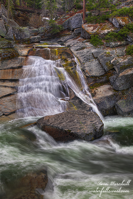
This is just a small 20 foot waterfall I found dropping into the Silver Fork American River. Girard Creek Falls. It is kinda pretty, but nothing too exciting.
I have hopefully a big July 4 weekend planned with lots of waterfall adventures. And family adventures as well. I’m not sure how I’ll do all of it in one long weekend, but I’m gonna try.
Posted in Northern Sierra, Waterfalls by leapin26: June 28, 2011
On Friday night I took off from work early and headed up to Foresthill again. This time to the Beacroft trailhead. But not to go down that crazy steep trail to the river. I was in search of new waterfalls and a new (old) trail.
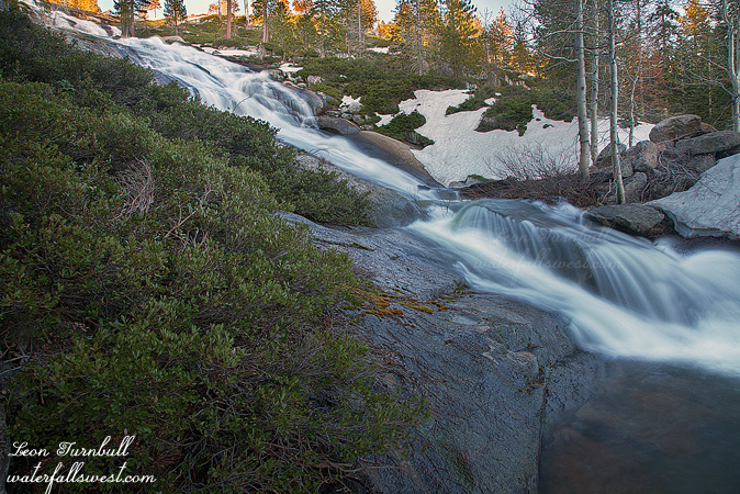
The Iowa Hill Ditch to be exact, and over to Tadpole Canyon Creek. This old old canal was built a long time ago, but never completed (thankfully!). You can still see (and follow) the ditch along the incredibly steep cliff side of the North Fork American River canyon. In some places, it is easy to follow. But in others, the trail has slid away, it is very narrow, the footing is very loose, and there are huge deadly dropoffs. I am not one for deadly dropoffs. They freak me out to no end. I debated about continuing. It looked ok. But if those loose rocks slipped from under my feet, I would be a goner. No thank you. Instead, I looked for a way up and around this section. It was a hard hard climb up the ridge, but once I got to the top of it, it was easy to traverse the ridge across the canyon, over to Tadpole Canyon Creek, and back down to the old ditch. It was more difficult, but much safer.
It also took me a lot longer to do this route, as I was anticipating an easy jaunt along the old canal over to the creek. I was hoping to get across the creek, and down the cliff on the other side to a huge waterfall on Tadpole Canyon Creek. But I had run out of time. Instead, I settled for this 20 footer. There were actually three small waterfalls here, as the creek tumbled down the hillside, and before it dropped off the cliffs below me. I did not have time to get down to the big one, but I will be back. The creek looked easily cross-able, and the cliff on the other side did not look difficult to get down. We shall see. Stay tuned.
On another note, after my hike, I drove up a few miles to Sailor Flat. The road is now clear to Sailor Flat, but there is a ton of snow up there still. Unbelievable really. The Sailor Flat Road is not drivable, and probably will not be for a few weeks yet. But one could walk from Foresthill Rd if one was interested in getting down to, say, New York Canyon. Count me in for that one.
Posted in Northern Sierra, Waterfalls by leapin26: June 25, 2011
I called the Foresthill ranger station and they told me the Foresthill Rd was now open to Sailor Flat. That means one thing and one thing only to me. Time to go to New York Canyon. I called up my friend Rob and met up with him out in Foresthill and off we drove to Sailor Flat.
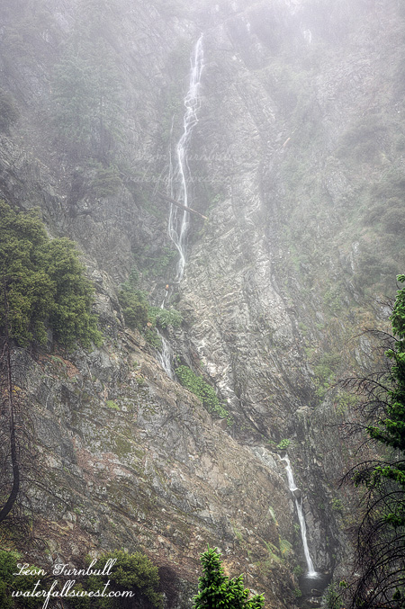
Placer County has been plowing this road which is quite odd as it is not normally ever plowed. I think I have an idea why. When we got out to the area of Canada Hill we found an absolutely unbelievable amount of snow still on the ground. About four feet of hard packed snow, and not patchy snow. Solid packed snow everywhere. Are you kidding me? Last week I was at the same elevation over on Ice House Rd and though there was some snow there, it was not much and quite patchy. Not only this but the ranger station lied. The road was only clear to Canada Hill not to Sailor Flat. This is a HUGE difference. It is a 1000 ft elevation difference by driving a mile down Sailor Flat Rd. I cannot believe we would even consider hiking down to the big waterfall from Canada Hill but off we went hiking along the hard packed snow. We saw many fresh bear tracks in the snow as we hiked along. There were at least 3 separate sets of prints. (mama, papa, and baby?) I came up with a grand idea of taking a short cut so we would not have to go down to Sailor Flat and cross the creek above the waterfall. This way did involve scaling down a steep ridge, and it especially did not help we ended up going down the wrong drainage and on top of a cliff. Rob the mountain goat found a way down that worked for him. But not so much for me. My legs were shaking as I made my way carefully down but then it got a heckuva lot steeper. Too steep for me to continue. Rob wanted to continue down so we split up as I decided it would be better to go back up and down the proper ridge. Fortunately I told him not to wait for me. I climbed to the top of the ridge. It was a very tough climb and it took a lot out of me. I started back down the proper ridge until it became steep. I realized it was still more than 1000 ft down to the big waterfall. It was getting late, and I was already quite bagged. I might be able to make it down but I knew I would not make it back up. I decided to head back up and wait for Rob at the car. On the way I made a pit stop and went down to a different waterfall on New York Creek. That was probably not smart as it was a steep descent and I was already very tired. Nonetheless, I did go down to it anyway and I was glad I did, and although it is not a great waterfall, it is still a nice one. I tried to get to it last year from Sailor Flat but it was not possible from that side. From this side, it was much easier.
It was a tough climb back out of the canyon. I had an hour until sunset, and it should have been easy to get back to the car in that time, but I was dead tired. I have only bonked once in my life before, being so completely tired and spent that one literally cannot take one more step. I was about as close to bonking as I could have been. I needed to lay down and rest for a good half hour, but darkness was approaching, and I needed to keep moving. I tried eating some of my sandwich, but I could not keep it down. I could hardly drink water without feeling like puking it up. My legs were cramping. Essentially, I could only take about 10 steps, then rest. 10 more steps, then rest some more. Eventually, I made it up the hill and back to the car. It was a little past dark when I got back. Rob was not there. I thought he might have gone back the normal way from Sailor Flat, a longer route, but easier. There was nothing to do but wait. Fortunately, I had cell service at the car, so I was able to call my wife and tell her the situation. Finally, at 10PM, Rob arrived at the car. It took him 3 hours to climb out of the canyon, and he was as tired and beat as I was on the hike back out, if not more so. I had been a bit worried that something may have happened since it took him so long, but thankfully he made it back all right. It was certainly quite a day in New York Canyon.
Posted in Northern Sierra, Waterfalls by leapin26: June 19, 2011
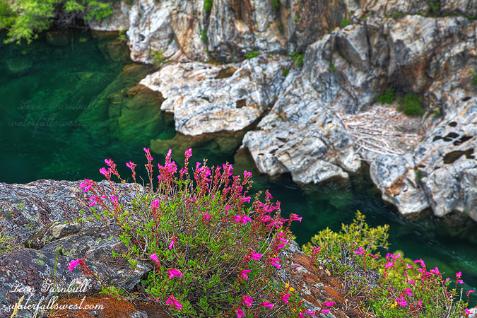
Last week my friend Rob and I went on a walk along the Rubicon River in search of a waterfall. We were not able to get to the waterfall, but we did find these pretty flowers overlooking the river so we just had to stop and scramble down to shoot them. No waterfalls perhaps, but at least the evening wasn’t a total loss.
Posted in Northern Sierra, Wildflowers by leapin26: June 16, 2011
After work on Thursday I headed back up yet again to Ice House Rd. I knew it would mean getting home late (which is difficult since I need to get up early for work) but I couldn’t go out Friday (hockey game) and I had other hiking plans for the weekend, so Thursday was my best option.
I brought my bike with me. When I was up here two weeks ago the road was still snowed in. Even though the elevation is lower than Bassi Falls (which was open) snow seems to really linger on this road. I figured if it was still snowed in I could bike the rest of the way to the trailhead. I thought it might be as there was still a lot of snow along the side of Ice House Rd as I drove up, but the road to the trailhead was thankfully clear (but I am sure if I came the prior week it would not be – I timed this one perfectly).
Even though I could have hiked all the way I decided to bike the first part (and I’m so glad I did). It is a three mile one way hike, the first two are along a dirt road. It is uphill all the way but it is very gradual so it is quite do-able on a bike. Nonetheless it is a tough climb on a bike and would have been much easier hiking (but a lot longer, and coming back down on the bike was so fast and quick).
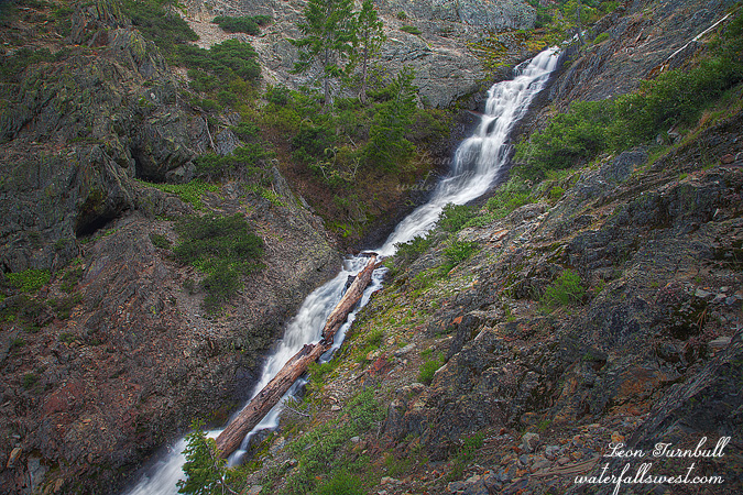
At the end of two miles you need to get off the bike and hike through the forest the rest of the way to the waterfall. At first the going was very easy but then the manzanita brush got a lot thicker. There was a bit of a path through the brush so I kept going. There was also quite a bit of snow still around, so I was able to walk on the snow over the brush (much easier than going “through” the brush). It took an hour to hike this mile through the forest and I arrived at the waterfall a bit later than anticipated. It was a beautiful and large cascade which I measured 251 ft high. Finding a good point of view to photograph it was difficult. Ideally I should have crossed the creek but I was not prepared for that. Plus I was out of time. It was 8pm, sunset was in half an hour. I quickly took some shots than literally ran back down through the forest, arriving back at my bike by 8:30. The bike ride back down the mountain was a breeze and I got back to my car just before it got dark. It was a great evening adventure (but I was sure tired the next day at work).
More info on North Fork Big Silver Creek Falls:
http://waterfallswest.com/waterfall.php?id=655
Posted in Northern Sierra, Waterfalls by leapin26: June 10, 2011
