I had not gone on a big hike since I ruined my back before Christmas. Well it was time to get back at it. One 11 and a half mile hike coming up. That would sure be a good test. Well long story short, the test was successful, and my back survived the big hike. The destination was Table Mountain in Oroville.
There was a lot of water on the mountain (or should I say, the table) and the waterfalls were flowing. Most of them were looking good, but not all were flowing greatly, and some were not doing too well at all. More water is still needed. It was supposed to rain in the night, that did not happen. It seemed more rain would be coming during the morning, but hopefully I could get to some waterfalls before I got drenched.
The killer cows seem to be getting bolder. They do not even move now when you approach them. They used to run away but not any longer. They just stand there looking at you. At least they didn’t come after me. Perhaps that will be some horrid event in my future.
Crossing the stream at the top of Phantom Falls, I managed to get across without getting my feet wet. A bit of an adventure, as the flow was strong, and I needed to jump (another good back test). Trepidation ensued, however, when I saw a bunch of cow bones beside the stream that had been thoroughly gnawed on by the local mountain lion. I wonder where the beast is today? The section from Hidden to Flag Falls is particularly frightening as you have to walk through a heavily wooded area, which is perfect for mountain lions to hide. And with my bright green raincoat, the lion would see me coming from a mile away and have plenty of time to find the perfect hiding spot to wait and pounce on me. Alas, I did not see the beast. But did he see me? I wonder.
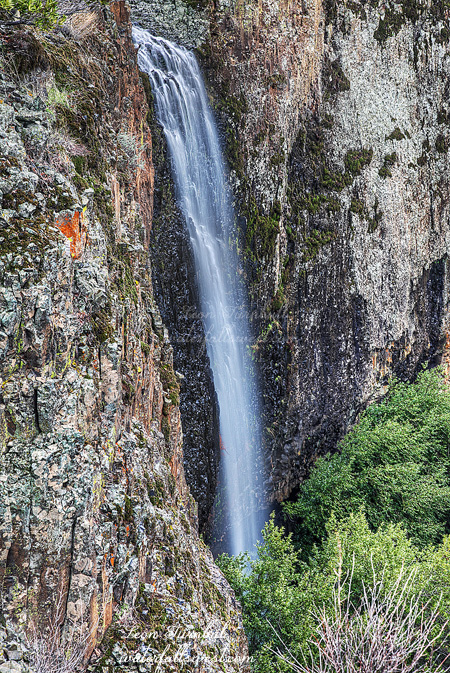
I went all the way to Flag Falls (pictured here). By the time I got back to Ravine Falls, I was very tired, and my back was starting to complain. I wanted to get down to the bottom, to find a new waterfall. There was a ton of poison oak down there and it was just a small falls and flow was minimal, but then I went over to the base of Ravine Falls and Ravine Twin Falls. Wow it is an amazing spot down there. It feels like another world. You are in a jungle. The falls are loud and intimidating. The basalt cliffs tower above you, and you wonder if any of that rock is going to fall on your head. It did not.
I was very tired and hungry by the time I got to the car. Big bad burger at Jakes. Enough said.
Posted in Northern CA, Waterfalls by leapin26: January 15, 2016
I took Monday off work to go hiking after the latest storm. Now I’ll probably have to take more days off work. And it won’t be for hiking.
I went up to Hwy 70 north of Oroville with big ideas in my head. Those waterfalls should be flowing nicely after the rain, ya think? Well so I was actually going to go on a bike ride first off, but there was a big huge rock in the middle of the road, and I was not able to drive as far as I wanted to, and then I had troubles getting my bike ready to go, so by the time I was ready it was getting very late and I decided I did not want to go on a much longer bike ride now, so I decided to skip it and go to a different location.
This hike was supposed to be very easy and short, so I did not bother to transfer my camera gear to my normal and proper backpack from the backpack that I would use for biking. I did not think it mattered. Big mistake. It was not such a short and easy hike. Indeed, it was incredibly steep, and I ended up climbing a mountain that was steep and quite icy. It soon became clear this was not going to work out, and I decided to turn around to try a different path. One missed step on the way down, and there goes my back. Ooh the pain. I am sure that this would not have happened if I had been wearing my proper backpack, which had proper support for my back. So there I was laying down on the side of a mountain in pain, in the middle of poison oak, and unable to get up. Ten minutes later, I figured I should do something to get off this mountain. I stood up, gingerly, slowly. I was on my feet. I still had to get down. I could not wear the backpack, so I dragged it down the mountain, through the poison oak, and slowly made progress, finally getting back to the car. It must have been a miracle that I was able to get down.
Okay so I still had a long drive home, and so far no waterfalls to show for it. I was able to walk a bit still, so I went to two roadside waterfalls, then I went to this one: Bear Ranch Creek Falls. It is an easy half mile hike to this waterfall, but it was tough for me with my back in so much pain, and by the time I got back to the car I was quite worn out. I probably should not have done that little hike, but I am glad I did because it would have been such a waste to drive all the way out there and have nothing to show for it. Of course I stopped at Jakes in Oroville for lunch on the way back and after that it was a very long and uncomfortable drive home.
So what now? I am definitely going to be out of commission for awhile. And I see now there is a lot of rain in the forecast through Christmas. You can thank me for that, since I will be in bed at home and not able to go out and enjoy it.
Posted in Northern CA, Waterfalls by leapin26: December 16, 2015
I guess you can say I was 2 out of 5 for the long weekend. That is a pretty lousy score if you want to keep score.
My hope was to get to two brand new waterfalls on this day. It started off well. In the dark. It was very dark. Walking down that logging road in the dark. With lots of spooky things around me making noises in the bushes. Some of those things sounded pretty big. And they sounded like they were stalking me. In the dark. But all I saw were a couple bunny rabbits. And they were not of unusual size if you know what I mean.
Things were all good until I hit the poison oak. The road ended. The brush began. I was not expecting that brush, I thought it would be an easy walk down to the bottom of the canyon. But that poison oak was monstrous. It was all over the place. I did not, I repeat did not, want to pound my way through all that. It was still a long way to the bottom, and no end in sight to the brush or oak. I decided to call it and hike back up the mountain. Even so, I think I got in a bit too much of the oak. Indeed, I did get a bit of the rash, but fortunately only a small bit.
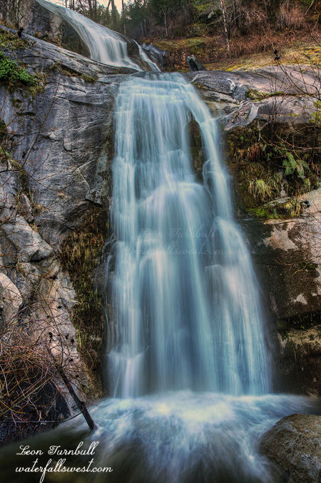
Well, I was really bummed about missing out on getting to these new waterfalls. I will have to re-plan and hopefully try again at Christmas time. But all was not lost. It was still early enough, that I thought perhaps, possibly, maybe, potentially, I might have time to hop down to Montgomery Creek Falls before it got in the sun. Whenever I want to go to that one, it always seems too late in the day, and too sunny, but today it was earlier since I ended my hike early. I scrambled down to the bottom of the canyon, and just barely, by the skin of my teeth, it was still in shade. I just had enough time to take a couple decent shots. It salvaged a disappointing day.
This is a fairly popular place, and easy to get to, and thus that means a lot of stupid people will come down here and leave their trash. I saw quite a bit and so picked it up on my way back up the hill. There was one old plastic bag that broke apart in my hands, getting plastic pieces all over me. It must have been down there a couple years, it was so old. I find it hard to believe that so many people could walk right by this trash for two years or so and not bother to pick it up (it was right beside the trail). Really, people? Why do we have to trash such beautiful places? Is it really so hard to pick up your litter and take it back to your vehicle? It seems to be the thing now for people to litter. The other day we were walking through a parking lot, and some guy on a bicycle came by and threw his bike light on the ground and kept going. I thought he just dropped it, so I said hey, you dropped your light. But he said he knew and just kept right on going. What??? You don’t want your light so you just throw it anywhere? You can’t go 1 minute out of your way to the trash can? Oh man, it just makes me so angry. Thus ends another rant. Have a nice day everyone.
Posted in Northern CA, Waterfalls by leapin26: December 2, 2015
REI thinks they are leading some sort of innovation with their #optoutside and not opening on Black Friday. Well I have news for them, they are not. I have been hiking on Black Friday for years. It has always been my favorite day of the year to hike. I know many of you also already opt outside on this day.
I don’t get why they are doing this anyway. They’re just losing money. I personally don’t care if people like to shop on Black Friday. In fact I prefer it. Then I won’t see anyone on the trails.
But either way I knew I wouldn’t see anyone on the trail where I was going on this Black Friday (and I didn’t).
Last time I was up in this area I was hiking with a bad back. That was not cool. I also saw a fisher. That was very cool. Neither of those things were true today. It was, however, only 10 degrees outside. Too cool (literally). It was so cold I put on an extra sweater for the hike. I knew I would be shedding it and have to carry it. Not cool. Sure enough less than a mile in I was sweating and I had to take it off. Oh well. At least I was warm for that first mile.
It occurred to me (after I had driven 150 miles to get here) that the creek might be completely frozen, which would mean no waterfall. That would most certainly suck. Fortunately though, it was not and it did have decent (but not great) flow.
After three miles or so my road ended at a creek crossing. The road actually continued on the other side but there was a huge dropoff. The ground was very icy and I just could not climb up the other side in a safe manner. I spent a lot of time trying but finally gave up. Not to be deterred though, I backtracked a half mile and crossed where it was less steep, then climbed up the other side eventually getting back to the road. Now I was worried about the inevitable descent back down to the creek, which would undoubtedly be icy and steep. Plus I was worried about the sun. I only had til 9:30 before the sun would be on the falls. Time was running out.
I came to the descent. It didn’t look too bad. Down I went … until the very last section I came to a cliff right above the falls. Seriously? All this way for nothing? I contemplated about what to do, and I almost gave up.
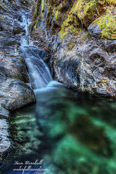
But again I was not deterred. I got out my rope and descended down to the creek. Not down the cliff! There was a slope down, it was very steep and as I said the ground was hard and icy but I carefully made it down. I could not have done it without the rope. Once down I realized I had to cross the creek to get the best view of the falls. You do understand that the water was freezing! It was very slippery too, but I made it across safely. Such a gorgeous 25 ft cascade in this remote canyon, and a stunning emerald green pool it dropped into. It was a fantastic Black Friday for me! And I saw absolutely no one all day.
Posted in Northern CA, Waterfalls by leapin26: November 30, 2015

I was quite excited to finally get to this 29 ft high charmer on the Little North Fork of the Middle Fork Feather River. It’s my first “new” waterfall of the season and I’m hoping for much more this winter and spring. Come on rain!
Now I knew there was a 30 footer on this river “somewhere” because I read about it from some kayakers but where it was exactly was a complete mystery and how to get there was even harder. It took three tries and much pondering of GE and topo maps until success finally presented itself.
The first time I had a vague idea where it might be but it turned out to be quite wrong. After that I realized where it was so I tried again and indeed I found it but I could not see it. In order to see it, it is necessary to cross the river and at that time the flow was much too high. Now I would try one last time. This time the river was lower but I was a bit worried it was still too high, especially after the recent rain that just happened. That rain would sure be nice for the waterfall but I somehow would need to cross that river. Well here I go.
It is a steep and difficult hike to get down to the falls. Much poison oak. Much steep cliffy terrain. When I finally got down to the river I could see it was flowing quite strong. I didn’t think I’d be able to cross it. Was this all a big wasted effort again? I had to try it. There were three steps I would need to make across the narrow torrent and avoid falling and being swept downstream, and probably over a few more waterfalls before I found myself in Lake Oroville. Well, it turned out to be not as bad as it looked. I was able to hold onto one rock, step out into the middle of the river, reach out and grab onto a rock on the other side, hold onto it for dear life and drag my other foot across through the torrent. Made it. I sure hoped I would be able to get back across though. Once on the other side I easily made my way up closer to the falls for a very sweet view and shot. It’s not a huge one, but sure is a beauty.
I took my shots and then hurried back across the river before it decided to rain any more and thus increase the flow in the river. That would certainly suck. I would probably be stuck down there until next summer. Bear meat and such.
My GPS was having troubles working down in that canyon, thus making it difficult to find my way back home. So I just went up. Up the mountain, back to the main trail which I was able to find with minimal GPS help. I got back to the car and as I was putting my bear spray away somehow the safety lock came off and I sprayed it all over my hands! I strongly suggest you not ever do this. I washed my hands off with the water in my water bottle as best I could, but I could not get it all off, especially under the fingernails. That stuff lingers on forever. And if you just happen to touch any other part of your body such as your face or eyes or any other certain parts, then it stings for a long time. Not that I did any of that, but just trust me, it stings. I can definitely see why the bears do not like it. Well I did make it home all right and got cleaned up, but now I just hope that I don’t get that dreaded poison oak itch.
Posted in Northern CA, Waterfalls by leapin26: October 18, 2015
