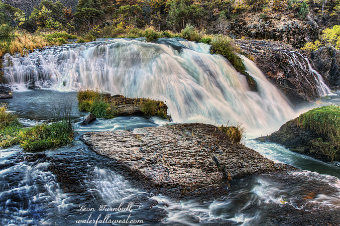
It’s a very very long drive out to Stirling City. I don’t often go there. Like I think maybe only once before. But I’ve been wanting to check out more waterfalls on Big Kimshew Creek and this seemed like a good weekend to do it. We’ve been dry for a few weeks now. Bad news. But I thought Big Kimshew would have water and it turned out to be more than I thought. The West Branch Feather River was hovering around 200 cfs all week (downstream of the confluence with Big Kimshew), so I estimated Big Kimshew might have about 50, but I think it was probably closer to 80 in actuality.
I had heard from the kayaking community that the road was now gated by Sierra Pacific. Permanently. If so, it would be illegal for them to do that, this is public forest land. Anyway I anticipated having to bike and was prepared to do that. Nine miles one way biking followed by a two mile hike. Total elevation gain would be around 3000 ft. It would not be pleasant.
I left my house at 4:30AM, and after the very very long drive (did I already say it was a long drive?), I arrived at the gated road at 7AM. By the way, when I stopped in Oroville at the gas station along the way, I saw a bunch of hunters all decked out in their gear getting ready to go out and shoot some things. One of them was Uncle Si. I’m not kidding you. He looked exactly like Uncle Si from Duck Dynasty. If he was not Uncle Si then he must have been a long lost twin. It was very weird. Anyway, onto my epic bike/hike.
I turned on my GPS when I got to Stirling City. Lo and behold, I realized that my map for this hike was not loaded into my GPS. This was an utter disaster! The waypoints for the waterfalls were loaded but my map did not get loaded. I distinctly and positively remember loading my map, so I have no idea how it did not get loaded into my GPS, but this was catastrophic. There is no way I could know where to go without a map, and yet, I could not just go home after that awful long drive (it was a horribly long drive to Stirling City, if you didn’t know). Hmmmm, well, upon much thought, I decided to continue. I had studied this route at home extensively, and I thought I would remember how and where I needed to go. It was worth a shot and better than going home with nada.
The sign at the gate seemed to indicate that the road was only closed during winter. I hope that is true because I am sure I will want to come back here, and not biking next time. The sign also seemed to indicate that the bridge over the West Branch Feather River was out. That could be a big problem, but fortunately it was not out. I did not want to be getting wet attempting to cross a raging river (well, not exactly raging but it would be wet). In nine miles, I gained 1300 ft. of elevation, and it was a tough climb. I was worried about my ribs, which I had injured hiking over the holidays. I have not been biking since then, and I was hoping the ribs would not complain about this big climb. Thankfully, they did not. Everything seemed to be going well as far as finding the correct route to take. I did miss one turnoff near the end and ended up biking an extra 100 ft. in elevation over a quarter mile, but I determined my error before too long, and went back to the correct turnoff, where I parked my bike. Now the hiking would begin. I had a total descent of 1200 ft. down to the waterfall. The first part was easy enough, along a logging road, but I had to eventually get off trail and hike down through the forest to the falls. Without a map, it was tricky to know exactly where to go. I came to an open area where I could see the falls in the distance. I had to traverse across the mountain side over to a ridge. I felt very odd. My knees were wobbly and the terrain was making me dizzy. It was not awfully steep, I have hiked steeper stuff, but it was steep enough that a fall could definitely cause serious injury, and I did not like it one bit. The terrain was freaking me out. Most of it was due to the bike ride, being that I was very tired from that big climb. But I think the wide open and steep terrain was also contributing to my state of being. Well, fortunately there was a lot of brush and stuff to hold onto, so I was able to make it over to the ridge. (on my way back up, I bypassed that traverse – I did not want to do that again). Things got a lot more brushy as I descended the ridge. I could not see the waterfall any longer, and without a map, I was not sure where exactly to go. When I thought I saw it through the trees, I exited the ridge and made my way down the steep terrain to the creek.
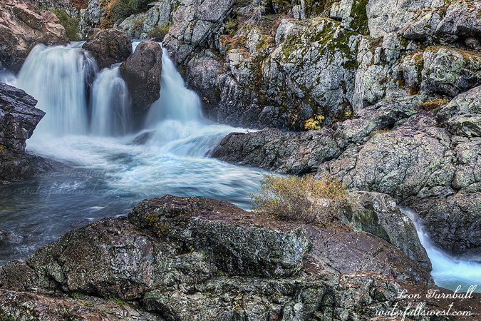
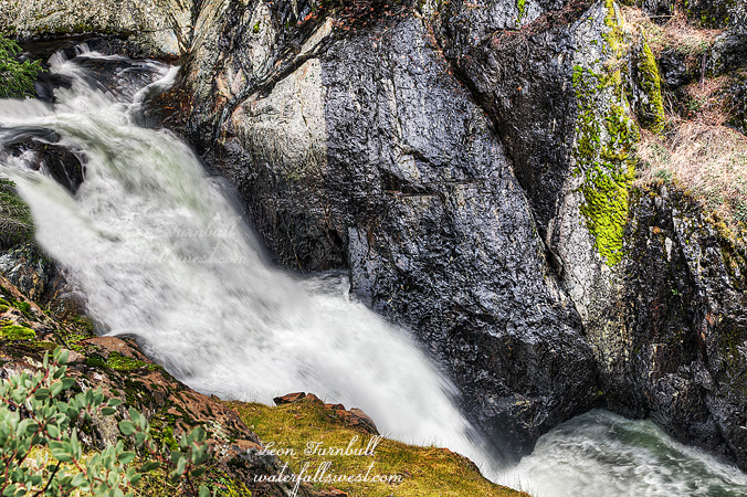
And there was the waterfall. Except that something was horribly amiss. The kayakers claim this waterfall is 50 ft. high. Well, I know they exaggerate heights and I was not expecting to find a 50 ft. falls, but this one was too small. It was less than 20 ft. high (17 ft. to be precise). Surely I was in the right location and this had to be the right waterfall. There was no other waterfall to be found. But then I looked closer. The main waterfall was actually above this little 17 footer, and hidden out of view behind a cliff, with no way to get over to it. I came down at the wrong spot! I was already completely spent and I still had a huge climb back out of the canyon but I could not leave without at least trying to get down to the main falls, so I had to climb all the way back up to the ridge, and then continue along the ridge and try to get back down at the proper spot. It was very tricky to find any view of Middle Big Kimshew Falls, but finally I was able to traverse along the cliff, and this is the best spot I could find. There was no way to get any better view of it, and even this spot was very scary to stand while I took this photo. Fortunately, my knees had stopped wobbling by now. I measured Middle Big Kimshew Falls to be 35 ft. high, much less than the 50 ft. the kayakers claim, but much better than 17 ft. also.
The hike down to the waterfall and back up the ridge took much longer than I expected it to take. I initially hoped to continue hiking down river, but I was already at my limit physically, and even if I wasn’t, I would have risked having to hike back in the dark if I were to continue any further. The bike ride back down the mountain was fast and awesome. The dirt road was very smooth and I was able to go very fast. When I got back to the bridge over the West Branch Feather, I still had 3.5 miles to go uphill (but thankfully, a very gentle uphill). Yet, as soon as I crossed the bridge and started back up hill, I got a severe leg cramp. I was in agony, I dropped the bike and laid down on the road for five minutes. This happens to me from time to time after huge hikes. Eating bananas help with the cramps, but I had no bananas with me. Well, after walking it off, I was able to get back on the bike, and continue up the hill without further incident. It was an awesome day in the wilds of Stirling City.