Another 2 inches of rain on Thursday/Friday, and that means Saturday is a waterfall day. Of course on Friday night I have to get sick. Our whole family is in the dumpsters now. I caught my wife’s bad cold (as did my two kids), and I slept awful on Friday night. Well, I could not let that deter me. If it was not a waterfall day, I surely would have slept in, but we have had so precious few of these days in the past 14 months, I had to get out even if I was puking every half mile. Fortunately, that was not the case. It was just a cold. Of course, I feel worse on Sunday because of it, but that is besides the point.
Another place I have not been to in a long while because of the drought: Table Mountain. In a normal winter, I come here multiple times. There are still places I have not explored here. I did come here once last year, but I cannot even count that time, because the flow was very low, and we only went to Phantom Falls, which was just barely a trickle. This weekend would be a different story. All the waterfalls would be flowing quite well, and they were indeed. It has been so long, and I am so grateful to God for the rain we have had in February – and yet we need so much more. This last little bit of rain pushed Folsom Lake up to 32 percent from 30 percent capacity. It will probably go a point or two higher from the runoff over the course of this week, but average capacity at this time of year is 55 percent. We are all praying for a miracle in March.
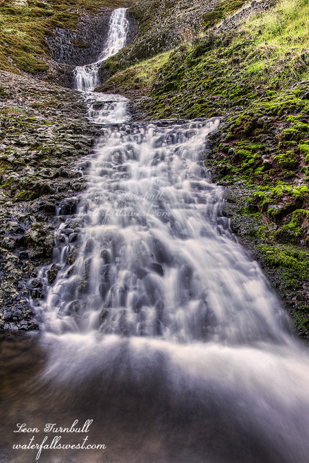
My plan of action was to go to Phantom Falls, Flag Falls, and beyond. First up, however, was Hollow Falls and Lower Hollow Falls (aka Catamount Falls). I had never been to the lower falls there before, though it is a very easy hike. Normally I leave Hollow Falls to the end, after my main hike, and by that time it is sunny out and pointless to go down to Hollow Falls. This time I decided to go to Hollow Falls first. A wise decision, madman. The lower falls is a really nice looking 45 ft. high cascade. That one is on a different stream with a very small drainage, and I was happy to see it flowing well. Hollow Falls was rocking. All in all a very good sign. I will be sharing all these other photos soon.
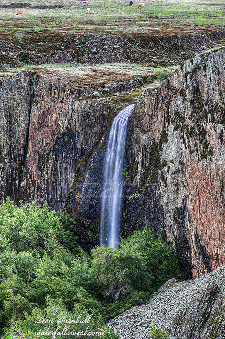
After this it was off to Phantom Falls. The sun was trying to come through, and I thought it would break before I got to Phantom Falls. Thankfully, however, the clouds rolled back in, and we got a couple more showers before the end of the hike, so I was worried about the sun for nothing. I have seen Phantom Falls at bigger flows before, but it was still flowing quite strong, and looking good today.
I crossed the stream at the top of Phantom Falls and continued on to Flag Falls. Why, you ask? I have been to Flag Falls before. Why would I want to go back there? It is such a long hike out that way. Well, I did not actually want to go to Flag Falls, but I wanted to go beyond it. There are a couple other waterfalls out that way on very small drainage streams. One of them looked like it was actually a very good size. However, you cannot see them! I could only get a glimpse of the first one, the very top of the waterfall, before the trees obscured it completely from view. If there were no trees there, it would be a great looking waterfall. The other one I could not see at all. This was such a bummer! They would have been awesome new finds. Someone needs to go cut down those trees beside that waterfall. It would require someone to repel down the cliff, however. Any takers? Ha ha, I’m just kidding of course.
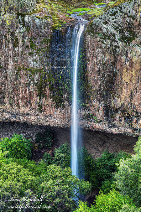
Anyway, after this I did not dawdle. I wanted to get back to Hidden Falls quickly. It is a bit freaky way out that far past Phantom Falls. I’m not kidding. When you continue past Hidden Falls on the way to Flag Falls, there is an area that is somewhat wooded, lots of trees, lots of places for mountain lions to hide. There are a ton of cattle bones around this area. They were scattered all over, I am not kidding. In other words, it is a high activity area for mountain lions, and I was very wary, looking constantly about me. It is a freaky place. Then I saw a big animal off in the distance. I looked closer, and saw it was a coyote! Well, that is much better than seeing a mountain lion. When it saw me, it took off. I think I got video of it, but it was a bit far away, so I’m not sure. Anyway, I got out of the wooded area, crossed over the stream at the top of Hidden Falls, had my lunch at the falls viewpoint there, at which point it started raining again, making for a wet lunch, then I made the long slow journey back to the car. It was certainly a great day on Table Mountain.