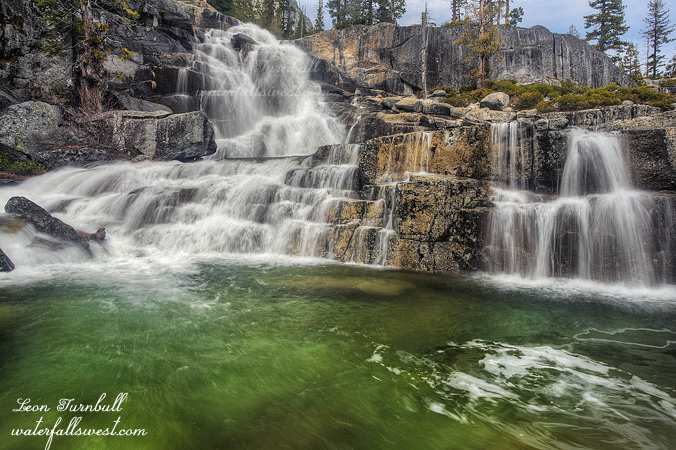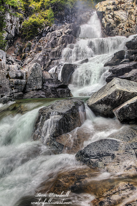
It is very early into waterfall season but without a doubt this monster waterfall on Canyon Creek in the Trinity Alps has taken an early and huge lead on being the most spectacular waterfall I have seen this year. Lower Canyon Creek Falls is an incredible cataract, an amazing 142 ft high, and ripe with full snow melt. Wow. Like I said it is early and I’ll probably be going to Yosemite sometime. But still.
Ok so you may be wondering (or maybe not) why I have not visited this popular hiking area in the Trinity Alps before now. There are waterfalls! I must be foolish! Well it’s not like I haven’t tried. The first time I was planning to go years ago I forgot my hiking boots back in Sacramento. Doh. Another time there was a forest fire in progress and the road was closed. Peachy. Other times since then the conditions just have never been right when I’ve been up north. You know me, I like to photograph waterfalls, and this hike is seven miles one way with multiple waterfalls, all of which all get early sun, so it is impossible to get to them in good lighting conditions … unless it is a cloudy day. Finally this Easter weekend the conditions looked right. The forecast was calling for “mostly cloudy” skies with showers in the afternoon. Time to get my boots on. Now just make sure I don’t forget them this time!
I don’t know about you but to me “mostly cloudy” means “almost all clouds” in the sky and very little clear sky … NOT … light scattered clouds with mostly clear blue sky. Humph. Well I started out hiking anyway with trust in God that those clouds would soon come. It reminded me a lot of the Tuolumne River hike I did last year under much the same conditions, and much the same kind of terrain, with the big difference being this hike started off going uphill and finished downhill (which is SO much better then the other way around).
I arrived first at Lower Canyon Creek Falls expecting to find a well traveled trail down to the falls. Surely there must be one, this is a popular waterfall is it not? I searched and searched but could not find anything and now I was well past the waterfall. This was rather weird I thought and did not figure out why there was no trail until much later in the day. I decided to keep plugging on up the trail and attempt to get to this lower falls on my way back down.
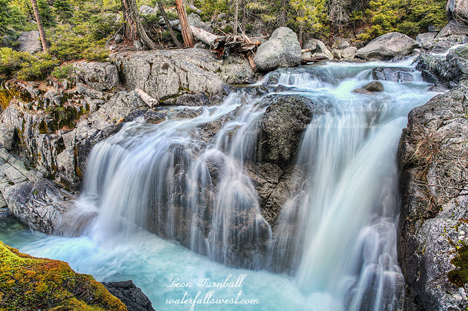
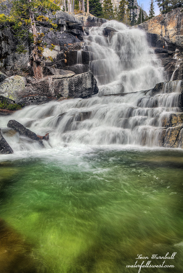
I arrived shortly at a surprise waterfall, a 30 footer and stopped to take some photos. After this the trail got much more difficult. Once I hit 4600 ft elevation I was hiking through snow. I had brought my snow shoes but did not need them, nonetheless hiking through snow is tough slogging and this section really wore me down. By the time I arrived at Middle Falls the sun was already out. Where were those clouds? I continued all the way up to the first lake. I had initially wanted to hike much further but I literally could not take any more steps up hill. I was worn out from the hike, most of it through snow, 2500 ft elevation gain, 7 miles one way, and a very heavy pack to boot (carrying those snow shoes all the way and I did not even use them!) Not to mention I still had to stop and photograph all the waterfalls on my way back down the mountain.
There are four major waterfalls on Canyon Creek plus numerous smaller falls including the 30 foot one I mentioned above. If you read Ann Marie Brown you will be very confused. She mentions only three waterfalls in her CA waterfall book. In earlier editions of her book, she completely missed the Lower Falls and thus describes the three uppermost falls as Lower, Middle, Upper. In her latest edition, she does now mention the Lower Falls properly, but she still ends up being very wrong, now she forgets to mention one of the other three waterfalls on the trail (and she still does not describe the true Lower Falls at all). As for that other CA waterfall guidebook, whose authors have clearly not even been to Canyon Creek, they just plainly copied Brown’s information (from her earlier edition), and also missed the boat, not getting the Lower Falls mentioned at all. (Gee I wonder who I’m referring to?) Both books completely neglect the most spectacular waterfall on Canyon Creek. It is really not hard to figure out. The USGS clearly labels the three biggest falls on the creek in the correct locations. The uppermost falls (65 ft high) is not labelled by USGS (though it should be, and it was my second favorite out of the four). So you want the correct info? Go to waterfallswest.com (the site will be updated very soon). I think this is why no good trail exists to the real Lower Falls. No one knew it existed. The vast majority of people hiking this trail are oblivious as they pass by such an amazing waterfall.
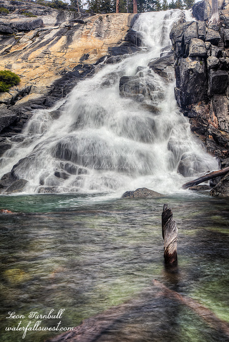
By the time I got back down to the Lower Falls I was dead tired. I figured I would have to descend from the main trail about 200 ft off trail down to the falls. I did not think I’d have the energy to get back up. I would be stuck down there forever. I did not want to go down. But I had to. So I did. As I descended I did not get too far before I almost gave up. It was very brushy and I was down on all fours crawling through it. I persevered however and got out into a more open area. I could see the waterfall now and it looked like a dandy. I was going to make it. When I finally got down to the bottom I was in awe. Sheer magnificence. Oh yeah, and by this time in the day the clouds had finally moved in (thanks again, God). It’s sure a darn good thing I decided to go down there. Immediately below this main section is another 30 ft drop. In order to take this photo I was standing at the brink of this lower waterfall. It was just a bit freaky, and it seemed much higher than 30 ft. Two steps to the left and I’d be writing this blog to you from my grave.
Before heading back up I filled my water from the creek. I don’t usually do this but it was an emergency. I was not worried about getting sick. The water was pure snow melt, flowing fast and clear. I was rejuvenated, and I made it back up to the main trail without difficulty (or dying). I still had four miles to hike before I was back at my car. These last miles were not hard but very slow going since I was so tired. Then my knee started hurting, most likely due to the heavy pack I was carrying. My knee was revolting, trying to wrench itself out of my body. That would be just perfect. Only one mile from the trailhead and my knee gives out. I’d have to crawl the last mile. I made it however, and I did not have to crawl. I was sure glad to be done, and then even more glad to get to Weaverville for dinner at Round Table Pizza. It was a great day in the Trinity Alps.