
It is not a waterfall. But it does roar.
This was from a family outing to the Sacramento Zoo a couple weekends ago. The kids (along with their cousin) had a fun time there seeing all the animals. And daddy had fun taking photos. I think this one was my favorite cuz the lion is looking right at me. 🙂
Posted in Sacramento, Wildlife by leapin26: February 7, 2011
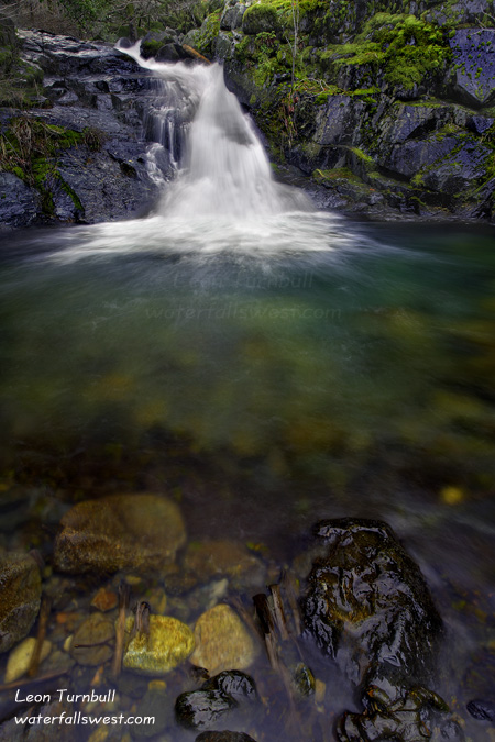
This is a little 12 ft. waterfall I found on Humbug Creek near Downieville, all part of my most recent grand adventure. I was looking for a big waterfall on Humbug Creek, and indeed I thought I had. But not exactly.
My adventure started off on the easy and beautifully maintained North Yuba Trail, following the North Yuba River up river. But shortly, we come to the Humbug Creek confluence, and that is where things get interesting. My goal is to work my way up Humbug Creek to the waterfall, which is hidden way back in the steep narrow canyon. There is no trail up Humbug Creek. Indeed there is no way to get up Humbug Creek, from creek level. I had to go off trail, straight up the mountain. Poison oak was very plentiful through here. As I climbed, I noticed a trail heading off to the right, traversing the cliffs along Humbug Creek. Obviously, other people had been up here before. I decided to follow this trail. I guess you could say that was a mistake. Though not totally, because it led to this small 12 ft. high waterfall on Humbug Creek. From the trail looking down on the waterfall, it seemed that it was much bigger than 12 ft. Because of this, I decided to try to get down to it, even though it was not my primary destination for the morning. It was a treacherous descent to say the least. But I made it, and once I got down I realized how small the waterfall was. It was a pretty one, but I was hoping for something bigger, so I took my photos and went back up to the trail (it was much easier going back up). The trail continued on, up Humbug Creek, so I decided to keep following it. This was my biggest mistake of the day. Eventually, the trail came to a dead end. The only way out? Straight up the mountain. About 1000 ft. up to the top. It was a tough climb to say the least, but fortunately it was not a sheer cliff, and it was climbable, though there were a couple tricky spots. It took me quite awhile to get up to the top. At the top, and after a good rest, I was able to continue going up to where I had initially planned to go. I was still going up the mountain, but the going was easier now, and there was a trail as well. I came to a rocky area, and I could see the very top of the mountain, which was straight up the rock. But I did not need to go up that section, as I came to a viewpoint of a towering waterfall across the canyon. It was about 450 ft. high, dropping in many tiers, tumbling this way and that down the mountain on the other side. The flow in the creek was fairly high, and it was a magnificent waterfall. I thought this was Humbug Creek and that this was my waterfall that I was searching for. Only when I got home did I realize it was Little Humbug Creek, not Humbug Creek. There was still another waterfall on Humbug Creek that I missed. If I had tried to continue, it would have been another 1000 ft. descent to the bottom of the canyon (and then back up), and the terrain was a lot steeper here, so I am not sure it would have even been possible. Nonetheless, you know I will return here someday and see if it can be done. I must find Humbug Creek Falls.
It was somewhat sunny, but I do have pictures of the waterfall on Little Humbug Creek:
http://www.waterfallswest.com/waterfall.php?id=1642
Posted in Northern Sierra, Waterfalls by leapin26: February 5, 2011
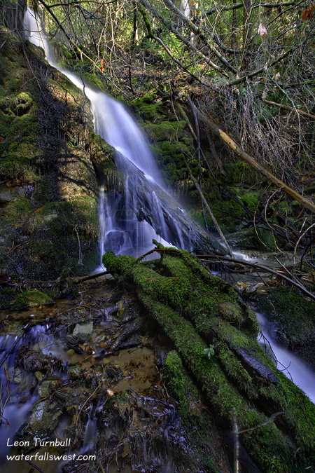
You may think I was lost out in the middle of nowhere getting to this small waterfall in a remote area of Eldorado National Forest. The name of this creek is appropriately Lost Canyon Creek. I was not lost, though maybe a bit crazy being out here. Actually, I was trying to find a waterfall on a different creek (Slab Creek). I did not find a waterfall on that creek, however I do still think there are waterfalls on Slab Creek, and someday I will get back out here and find them.
It is a very long drive out to this area. It is probably less than 60 miles from where I live in Folsom, but it is a slow, winding road, and it took a lot longer than I anticipated. In addition, the road had a large number of potholes, and there were a lot of fallen trees in the road. This made for very slow going as I constantly had to slow right down to drive around all the obstacles. And after striking out in my search along Slab Creek, I really did not want to go home empty handed. And fortunately, I just happened to see this small waterfall on Lost Canyon Creek as I was hiking up Slab Creek. Admittedly, it is not much of a waterfall, and not very photogenic with all the fallen logs and branches in the way. But it was still better than going home empty handed.
http://www.waterfallswest.com/waterfall.php?id=1641
Posted in Northern Sierra, Sacramento, Waterfalls by leapin26: February 2, 2011
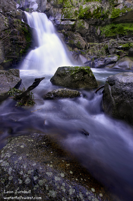
Happy birthday to me! I ventured out on my birthday to try to find a new waterfall and I found one! I must say that made for a great day. What better way to spend your birthday than scrambling through brush and poison oak, down steep mountainsides, and ending up at a fabulous hidden waterfall!
I definitely was surprised though, that I found anything at all. I was not sure if there was even a waterfall on Tiger Creek. Well, I knew there was one somewhere, but I did not know exactly where. And I thought it would be just a small one in the 20 ft. range, if there was one at all. The biggest thing though, was that on Google Earth the terrain looked very brushy and steep. I did not think I would even get down to Tiger Creek at all. As it turned out though, it was not really too steep or too brushy. Certainly I have done much worse in my days. I made it down to the creek where I thought the waterfall might be without too much difficulty. But there was no waterfall there. Just a very small little drop, maybe 10 ft. or so in height. That was not what I was hoping for. Maybe there was not any waterfall on Tiger Creek at all. Well, I thought, it might be upstream. I had marked a secondary location possibility on my GPS, about a half mile up the creek, so I headed up in that direction. And when I got there, I found a very nice little 20 ft. falls. It made me very happy that I had found a decent waterfall on this creek. I had to photograph it from the other side of the creek, so I put on my water shoes and went across. It was EXTREMELY COLD. While photographing the waterfall on the other side, I saw that there was an upper (and larger) waterfall above it. This made me even happier! I took my photos, went back across, tried to warm my numb feet, put on my hiking boots, then went on to this upper falls. It was really a beauty, a 2 tier drop totaling 43 ft. in height. It would have been perfect if it were not for a large tree that was blocking the view. The only way, again, to photograph it would be from the other side of the creek, but this time, it was not possible to get across. It was flowing too fast up here and too deep. With a little less flow, it could have been crossed quite easily I think. But I didn’t really want to fall and go over that 20 footer below. So I tried to photograph it as best I could from this side. The photo pictured here is the middle tier (the upper tier is immediately above and out of the picture). I will definitely be returning to this one someday.
http://www.waterfallswest.com/waterfall.php?id=599
Posted in Northern Sierra, Sacramento, Waterfalls by leapin26: January 26, 2011
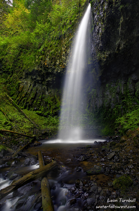
I have been to the Columbia River Gorge many times over the years, but I never made it up to Upper Latourell Falls. There are just SO many great waterfalls to see in the Gorge, and time is usually very limited. It is impossible to see them all in one trip, and decisions have to be made. Upper Latourell Falls was always the one that was cut out. Not this time.
But actually, Upper Latourell Falls was not on my list “again” this year. I was not planning to go here. Again, too little time and too many waterfalls to see. On my last morning here, I had plans to see some different waterfalls. But this time, circumstances changed and I updated my plan. Mostly it was because I was too tired, and the ones I had initially planned to see would be tough ones, so instead, I decided to go to a couple closer and somewhat easier waterfalls (namely, Triple Falls and Oneonta Falls, and then Upper Latourell Falls).
Upper Latourell was the last one I saw on this trip. It is a nice one, dropping 122 ft., but is not particularly easy to photograph the entire waterfall. This is the lower section, and it looks quite like Oneonta Falls, which I had just visited an hour earlier. You can also get up in behind this waterfall as well. I finished the hike about noon, and fortunately it was overcast so I had good lighting. Then after lunch, I made the long drive back to California. It so happened that it was a Saturday, and both the Beavers and Ducks had home games this day. I-5 was totally clogged up with traffic, by fans from these teams driving down from Portland to see their teams. All the cars on the freeway had their Beavers or Ducks flags waving from their cars. It was crazy. And it did not make me happy, trying to make decent time back to California. Well, it took awhile, but I finally got by them all and made it back to California. Geesh.
http://www.waterfallswest.com/waterfall.php?id=1571
Posted in Columbia River Gorge, Oregon, Waterfalls by leapin26: January 23, 2011