2 out of 6 waterfalls. Epic fail. Due to circumstances beyond my control I could only see two of the six waterfalls I had planned to see. I was probably lucky to even see two. I will get to all the things that went wrong in this post and some in the next post.
This was supposed to be my big fall October trip that I do every year where I see many waterfalls. Initially I had planned a 9 day trip but unfortunately had to cut it back to 4 days instead. I had an ambitious schedule but I should be able to see at least 6 waterfalls. Huh.
I only gained 2.5 pounds over the summer. Not too bad at all. But I knew I had a big hike upcoming. For the prior six weeks I worked out extremely hard and lost that 2.5 pounds plus an additional 2 pounds. I feel as though I am in the best shape I have been in 24 years. My wife thinks I am too thin. I guess she likes a chubby man, but what she does not understand is that 10 pounds makes a huge difference in backpacking. I feel I am ready to tackle anything now. I remember many years ago when I was out of shape, my friend and I went up Brokeoff mountain for sunset. He had along a couple young friends in their early 30’s who zipped up the mountain like there was no tomorrow. I made it up to the top but there was no way I could come even remotely close to keeping up with those young’uns. Now 15 years later, although I am much older, I feel like I could actually keep up with them. Or very close anyway. And this trip would be a tough one: 17 miles. 11 miles (with big elevation gain). 12 miles (with big elevation gain). 16 miles. Something like that.
It is a long drive to the trailhead at Courtright Reservoir. I arrived at 9 and started my hike at 9:15am. A bit later than I hoped but it was all right. There were no bugs at the trailhead but I decided to take my bug spray anyway. I would not regret this decision. (I almost left it). There are not supposed to be mosquitoes in October. That is why I like hiking at this time of year.
It is a 17 mile hike to my first campsite on the North Fork Kings River. It is a gentle climb with 1600 ft. elevation gain. The trail is mostly very good. I saw just one couple on the first day and one guy on the last day. No one else for the entire 4 days. I felt good on the hike. The last hour with the final uphill push to the camp was a bit rough (fatigued) but otherwise it was very good. I arrived at camp ahead of schedule even with the late start.
There were mosquitoes. Strike one. How the heck can there be mosquitoes? There was a winter storm last weekend. There was a hard freeze here at this elevation. All the mosquitoes should be good and dead. There should not be any! It was actually very frustrating to me. I hike at this time of year because it is very pleasant and there are no bugs. It is not pleasant when there are mosquitoes. They are so annoying. Argh!
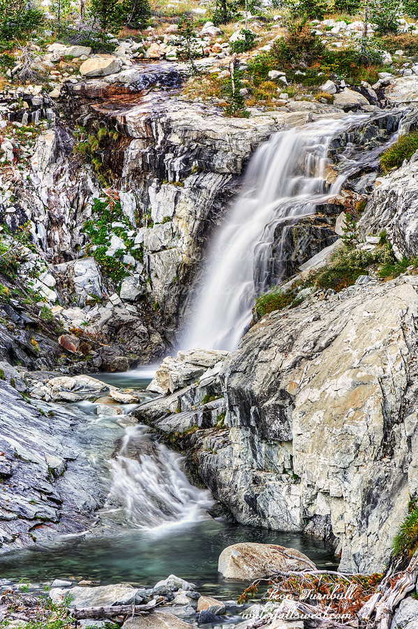
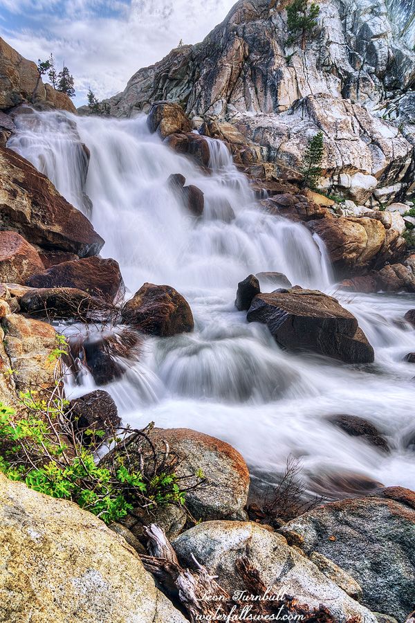
I went down to see the waterfall. Strike two. It was very disappointing. The North Fork Kings River had a good flow, but this particular waterfall needs a lot of water to look decent. It probably needs to be at flood stage for it to look very good. At medium flows it is not even worth taking a photo. I would not really even call it a waterfall. I guess I should come back at high flow and see if it makes a difference. I’m not sure I will ever be back but who knows.
Now for the other things that went wrong on this trip … let’s see … my watch strap broke. Not a problem. One of the zippers on my day pack broke. Not a problem. My first aid scissors broke. A bit of a problem but I was able to use my knife to cut the moleskin. My sleeping pad failed. A huge problem. It had a very small leak and I could not figure out where it was coming from. The ground was too cold (and hard) to sleep on without a pad. This was a major issue. I put my backpack down and slept on it. This was very uncomfortable as you can imagine but I actually slept quite well the first two nights. The third night not quite so well. I should have just gone home after the first night and I thought about it considerably but I decided to continue on. I really really really did not want to go home. That would have been horrible. Instead, I would just suck it up and sleep on my backpack each night.
There was one other major thing that went wrong. We’ll talk about it in the next post.
In the morning I got up early, had my breakfast and coffee, and continued up the trail. Almost immediately the trail deteriorated. Up to this point it was great, very easy to follow, smooth, no blowdowns. Now it was very difficult. There were a ton of blown down trees to negotiate. The trail was very indistinguishable at times. I persevered and it got a bit better up to Portal Lake. It took longer than I hoped getting this far.
From here on there was no trail. The rest of the hike over Mantle Pass and down into Blue Canyon would be cross country but I was not expecting it to be too difficult. It was horribly difficult. It is 1000 ft. up to the top of the pass. Straight up. This part was tough but not unexpectedly tough. Does that make sense? I knew it would be a tough climb but it was straight forward. The pass is just under 11,000 ft. elevation. (about 10, 970 ft.). Once over the pass you have now crossed into Kings Canyon National Park. There are no signs. The other side down into Blue Canyon was absolutely brutal beyond brutal. I actually thought it would be a fairly easy descent. Wrong. Wrong. Wrong. The descent is about 900 ft. off trail and then another 800 ft. on trail. It was extremely rocky the entire way. The rocks were big. It was very tricky walking on them. It was tremendously slow going. It was maddening. Was it ever going to end?
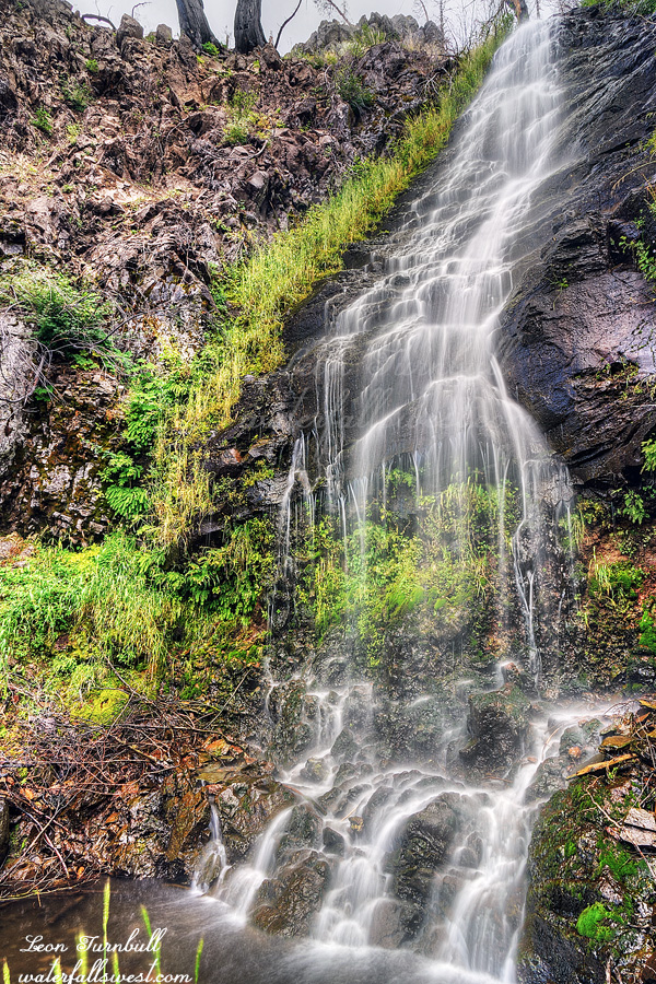
I finally made it down to Blue Canyon Creek and found a campsite. It was quite late now. Much later than planned. I had wanted to go down to the waterfalls in the evening but I did not have time. I only had time to go down to the upper falls (shown here). Upper Blue Canyon Falls is a gorgeous 40 ft. drop. It was a lovely evening at Blue Canyon in Kings Canyon National Park (except for the mosquitoes).
On Sunday afternoon I decided to go back to Lassen again. There was still some lingering rain hanging around but I managed to avoid it on the hike.
It is not too difficult getting down to this waterfall. It is steep but not cliffy. It is not easy though and there are many loose rocks for breaking your ankle upon. It is also very well hidden. So well hidden that no one else knows it is here. I mean no one. Almost no one. I know of just one person that has been to this waterfall and he used the data on my website to find it.
It is a beauty though, if you can find it. Lower Bluff Falls is 47 ft. high. A lovely little hidden gem. It is also well named (I named it, thank you very much) because, just like the upper Bluff Falls, there is a bluff here at the lower falls as well.
Going back up the mountain is a tough climb but I felt much better on this hike (even though it was harder than Paradise Meadows). I guess I was just too tired the previous day. It was another beautiful discovery in Lassen Volcanic National Park.
We went up to visit my wife’s mom on the September long weekend. It had been awhile since I have hiked at Lassen Volcanic National Park and I wanted to get back there. I had new waterfalls to discover.
The rain was off and on again all day. When I arrived at the Hat Creek trailhead it was raining quite heavily but by the time I got my gear all ready to go it had let up. Off I went up the trail.
This is an easy hike but I really struggled on it. I don’t know why. I have worked out over the summer and I feel that I am in good shape. I have a huge hike scheduled later this month which will be very difficult with lots of elevation gain and at high elevation as well. This one only has about 600 ft. elevation gain and is not at high elevation. Am I just not in hiking shape? Or is it just because I felt tired on this day for some reason?
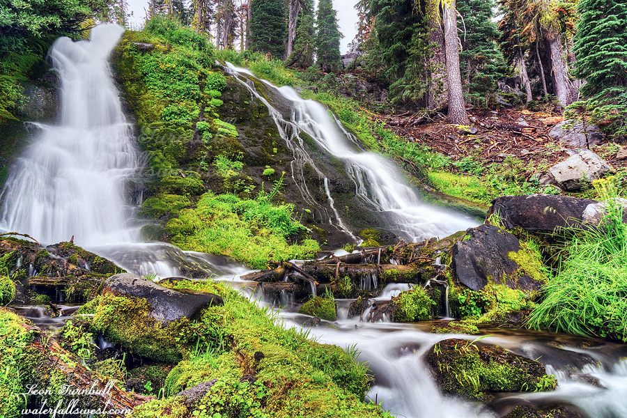
I made it up to Paradise Meadow and continued cross country. It was easy going. I saw a couple deer. I saw no evidence that any human had ever been over this way. I arrived at the creek and went downstream a bit, and voila! New waterfall discovery! This is a very gorgeous 33 ft. high segmented waterfall. Thank you very much, Madman. Or should I say, Rain Man.
It started to rain heavily again as I finished up photographing the waterfall. I hid under some trees and ate my dinner. By the time I got back to Hat Creek the rain had stopped so I photographed a couple of those waterfalls as well. When I got back to the car I could see about 3/4 of the mountain (I could not see any of it earlier), so I took a time lapse of the clouds rolling over the peak. It was a fabulous rainy day in Lassen Volcanic National Park.
(Who recognizes this quote? – Disclaimer: I did change the spelling of the name)
Although there were no mosquitoes at my camp the previous evening, they came out to feast in the morning. It was a terrible nightmare at Lewis Lakes Creek. I should go back to sleep. Argh.
When I arrived at camp at 2PM the previous day I found the crossing of Summit Creek to be very easy and mellow. I would have to cross it to see the waterfall. By evening, the creek had risen at least one foot and now it was flowing very swift and strong. The water was up to my thighs and had a strong pull. I crossed it, but just barely. However, in order to see the Lewis Lakes Falls you need to cross that stream as well. That creek was completely uncrossable in the evening. I would have to try again in the morning. Hopefully it would be down enough by then.
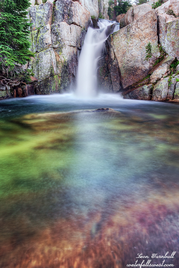
In the morning both creeks were down, although not as much as I hoped. It was enough. I was able to cross the Lewis Lakes creek (not easily) and made it up to the waterfall. Lewis Lakes Falls is 20 ft. high and it is incredibly pretty. It is located in a gorgeous setting with a stunning green pool and rising cliffs above. It was a short but fun adventure to reach it.
I returned to camp, packed up, and headed back down the trail. It was about 8 miles and took me 3.5 hours, most of it downhill. I forgot to mention earlier that this trail is absolutely horrible. Much of it is very rocky and has awful built in rock steps. I hate this. It is 3 times as hard lifting your legs over these rock steps. Some of the steps were huge. Not to mention that I almost tripped on the rocks and twisted my ankle many times. I think some of these rocky steps may be necessary on a trail like this but much of it is pointless. Why couldn’t they just build the trail properly? Anyhow, I arrived back at the car at 10:30am and drove home. It was a very grand but buggy adventure in the Emigrant Wilderness.
It did not take long for the mosquitoes to find me after I got up and out of my tent. Maybe one minute. They were horrendous. Swarming around me. Ugh!
I was not sure what I wanted to do this day. I could hike back on the trail about half way and camp another night, beside another waterfall that I still wanted to see. Or I could hike back the entire 17 miles and drive home. There were pluses and minuses to both options. Obviously I would miss the other waterfall if I hiked back the entire way and also I did not think I would have the energy to do a second 17 mile day in a row. On the other hand, the mosquitoes! I did not really want to camp a second night if the mosquitoes were so bad and I might even consider giving up the chance to see a waterfall. I decided to play it by ear and make a decision once I got to the second campsite.
First things first. I had two waterfalls to see this morning on North Fork Cherry Creek below Emigrant Lake. It was a short hike from my camp to the waterfalls, about a half mile or so, and it was easy getting down to them. They were both just over 30 ft. high and both outstanding. There was a bonus 19 ft. waterfall as well (I love bonus waterfalls). I ate my breakfast at the bonus waterfall where the mosquitoes had left me alone for a moment.
The picture shown here is the upper of the two main waterfalls on North Fork Cherry Creek. It is 34 ft. high. It is a bit smaller than expected but I think I must have included the bonus waterfall just above it in my calculations, which turned out to be a separate waterfall. Either way it is spectacular.
I returned to camp and started my hike back. Along the way I dropped my GPS on the rocks and it broke. Ugh. I feel that it should not have broken on a short drop like this but it did nonetheless. This is a good lesson for everyone and something I have said many times before: ALWAYS HAVE A BACKUP NAVIGATION DEVICE. I did have a backup although I did not need it because this entire hike is on-trail and easy to follow. However, that may not have been the case if it was a different hike.
There is a 600 ft. climb from Emigrant Lake up Mosquito Pass and then the rest of the hike is downhill. It wasn’t easy but it wasn’t too hard and I made good time. I arrived at camp at 2PM. It was clear to me well before I arrived that I did not have the energy to continue my hike all the way back to the trailhead. It was still another 4 hours. I needed to camp another night. Fortunately, there were no mosquitoes here but would they come out in the evening?
I had a lovely afternoon at camp, trying to hide in the shade from the sun. I saw quite a few people that came by on the trail (in both directions). These were people mostly going to either Sheep camp (a couple miles up the trail) or to Emigrant Lake (where I had just been). I was actually kinda surprised there were so many people this far up in the wilderness. I thought I would see very few, if any. I also saw some people on pack horses going up to Emigrant Lake. I wondered how the horses would do going over the snow on Mosquito Pass. I don’t know anything about horses (I should ask my sister), but wouldn’t it be very dangerous for them? It seems to me (since they are much heavier than me) that they are going to posthole and potentially break their leg. In addition there were a couple possible dangerous sections on steep slopes that were not difficult for me, but for a horse? I hope those people knew what they were doing. Anyhow, I had to figure out a way to make my dinner without my pan that I stupidly left at home. I melted the cheese in my pot and made a sandwich. It burned the bottom of my pot but it worked well enough. It was now late in the day and still no mosquitoes. A few came out at sunset but not many. I climbed into my tent and went to bed. I would have to see the waterfall in the morning (see next post for the reason).